Author: Rick Harrison

  • Car Wars: Should Autos Rule The Road? Part II

    We have a severe drug problem, we’ve been told, that mostly affects suburbanites. The dangerous drug is not taken by mouth, nor by injection, yet it is used daily by every family member and must be stopped before we, as a nation, are utterly destroyed. According to many experts, our “dependence” on cars must stop.

    Internet rumors abound that we are about to be legislated out of our stupor, and be taxed into high density, inner core cities. Should this rumor become fact, let’s look at what effect it will have on our economy, and, quite frankly, on the American Dream of home ownership.

    Today, the housing market is still dealing with the disaster of plummeted prices. Since 80% of the new home market this past decade has been suburban, it would be safe to say that 80% of Americans that bought in this century are the hardest hit, because these new homes have dropped to pre-boom pricing. It has been young families, generally, that have driven out to the suburbs to find new homes, the promise of lower density, and newer safe schools. In addition, many (most) of these families believed that their homes were a source of income; after all, values were increasing 10% or more annually, and that equity could be tapped in loans, (both suburban and urban).

    While many think of the suburbs as pure white, that is no longer true. The suburbs today, in general, are intermixed with all races. But the new race being ridiculed by many is the “suburbanite”. The suburbanite yearning for his or her daily fix of the car, consuming our fuel, and spewing carbon into our atmosphere must be eradicated at all costs.

    So how do we eradicate this vermin? There are rumors of a carbon tax that will place a financial burden on those vehicular junkies. Who cares that this major portion of America’s population is under the most financial pressure since the depression. If we tax these infidels, that will surely bring them to their senses , and we can cure their dependence on Chevys, Fords, and Mini-vans. Let’s break their backs once and for all, so that these families will abandon what is left of the suburbs and be forced back to the inner core. If reason does not work, we can just legislate it.

    Let’s imagine this new future filled with promise of a new America. In this fantasy, we visit the Smith family, who moved from their 10,000 foot suburban lot into the urban core. Adam Smith, the father, now must take the bus to the train station for the new light rail line that goes to Edenville, his job out in the suburb as a plant manager (it seems that his place of employment did not make the move). With connections, he can make it to work within an hour, whereas his 10 mile commute from suburb to suburb took 20 minutes.

    Lilly Smith (his new wife, as the old one refused to move into a 20 story inner city high-rise) works at Bester Buy on the edge of the city. She needs two bus connections to get there Having a car is not an option, since parking costs are prohibitive in the city. Luckily, the kids are old enough to be left alone; Josh is 8 years old, Jane is 12, and Joey, who is 15, watches over the siblings. Today is a holiday and they are home from school, but the cold rainy day keeps them inside, along with hundreds of other kids who play in the vast corridors.

    Lilly arrives at work, only to remember that Jane had a dentist appointment which she forgot about. She shivers, thinking about the old days, and the warm comfort of the Mini-van she once relied on to take her kids to appointments. She breaks out into a sweat and falls into a stupor. Her fellow workers recognize the symptoms, as they too have been weaned of their dependence upon personal vehicles. Her manager, Ralph, lets her take a week of sick leave to get help.

    Ralph is lucky. He lives in a single family neighborhood on the edge of the city. He has his own large lot, a spacious 35 feet wide and 90 feet long. He and his wife each posses a car. His luxury two story home, setback five feet from the sidewalk, is 25 feet wide and 50 feet deep; the house itself is a massive 2,500 square feet, over twice as large as the Smiths inner city apartment. He also has three children who enjoy the privacy of their back yard. The garage adjacent to the 12 foot wide alley consumes 440 square feet of their remaining 1,200 square foot rear yard. Still, with 760 square feet of green space, the kids are lucky.

    Ralph and his wife, Mary, both drive electric cars. Mary has the larger vehicle, with a 50 mile range per charge on a warm day. Their daughter wants to play with a cousin who still lives in the suburbs, 20 miles away. This is a cold day, which reduces the range of the vehicle to 35 miles, and their cousins do not have a charging station, so their 11 years old daughter is driven to the Light Rail station, a mile away.

    A week later, back at the Smith apartment, an argument starts between Adam and Lilly about her desire to get out of the city. Even if they did move out to near Adam’s plant, they would need Lilly’s paycheck to make ends meet, so she would need the light rail and two bus connections to get to work. Lilly begins to sweat and shake again… When Josh asks what is wrong with Mommy, Adam explains about the days when Americans were drugged out on their cars, the days when people were free to go when and where they wanted. As he describes those terrible times, he too yearns for those days. Adam and Lilly dream of moving out to a place with space, if only the carbon tax on moving out of the city could allow it, but alas, it’s only a dream that only the wealthy can now afford.

    A fantasy? Here is what I’m experiencing as a planner. When I met with a city official a few weeks ago I was admonished for a proposal that included attached garages. I explained that attaching the garage reduces 40 feet of exterior wall to be built, and here in Minnesota, an attached garage means you do not have to shovel snow between the home and the garage, nor slip on the ice. Why would I detach a garage, I asked? The city official explained that according to his planning staff, the space between the garage and the home is a social gathering spot where neighbors can stop and talk about their day. I had thought that’s what that large front porch we are proposing on the homes was for.

    There is a movement to prevent the toxic drug — the car — from infecting our lives. For me, no way you are taking me off my ERPT — Extremely Rapid Personal Transport — dependence.

    This is the second of a two-part series in which different authors examined the centrality of the autombile in urban and suburban life.

    Photo by Rick Harrison of the author’s ERPT — his Porsche.

    Rick Harrison is President of Rick Harrison Site Design Studio and Neighborhood Innovations, LLC. He is author of Prefurbia: Reinventing The Suburbs From Disdainable To Sustainable and creator of Performance Planning System. His websites are rhsdplanning.com and performanceplanningsystem.com.

  • The EPA: Leading Into A Rain Garden?

    Newly-installed solar Panels on the White House are an obvious signal that this administration wants to lead by example. Conservatives will no doubt find ways to ridicule the panels, and liberals will praise them as a display to the world that we are a green nation. About one year ago, on Oct. 5, 2009, the President signed Executive Order (EO) 13514, “Federal Leadership in Environmental, Energy, and Economic Performance.” Like the white house solar panels, this EO also is intended to urge federal agencies to lead by example. It sets as policy that federal agencies shall “…conserve and protect water resources through efficiency, reuse, and storm water management.”

    How far have we come… and how far are we likely to be able to go in achieving these goals?

    For federal facilities, the EPA’s green infrastructure solutions , biological systems and engineered systems include, but are not necessarily limited to:

    • Rain gardens, bioretention, and infiltration planters
    • Porous pavements
    • Vegetated swales and bioswales
    • Green roofs
    • Trees and tree boxes
    • Pocket wetlands
    • Reforestation/revegetation
    • Protection and enhancement of riparian buffers and floodplains
    • Rainwater harvesting for use (e.g., irrigation, HVAC make‐up, non‐potable indoor uses)

    For new facilities, these would be good moves. For many years, our design firm has been planning new developments with very low environmental impacts, using approaches that have been either volunteered by the developer or mandated by the local regulations. We accomplish low impact designs by reducing the infrastructure needed for new development, which reduces both economic and environmental impact. Land development can be more efficient, when designed properly, than conventional or Smart Growth design methods; it can allow lower development costs while still complying with EPA mandates. It can be done by harnessing new design methods made possible by the development of new technologies. While “green” brings an image to builders’ minds of expensive, problematic development, being “green” can be less expensive if done right.

    Speaking from my experience in designing 700 neighborhoods in 46 States (and 13 countries), all with innovative design methods, and building a Net-Zero home in 1983, as well as a dual-certified Green home in 2009, here’s how I evaluate the likelihood of success of the current EPA options:

    Rain gardens, bioretention, and infiltration planters: These organic methods are possibly the most economically viable, but they do come with constant maintenance costs that the building facility owner must be aware of. A bio-retention that is not designed properly or maintained constantly will quickly fail. Unlike concrete pipes and iron sewer grates along curbs which can be left alone for decades, an organic solution to storm water must be installed by an experienced expert with a proven track record, and maintained by personnel that know what they are doing. If built correctly and maintained constantly, this can be the lowest cost solution IF there is enough land area and proper topography (flow of the land) to design the system properly in the first place. Typically, these systems rely on surface flow with no curbing or special curbing to allow drainage off paved areas. On newly developed sites, this could mean a significant cost saving. On existing development, replacing curb may be expensive.

    Porous pavements: Sounds simple – install a pavement that allows rain to flow through to the ground. The big problem and huge expense comes from making sure that the ground under the pavement also porous. In other words, if you were to remove an asphalt parking lot and replace it with porous asphalt, the environmental impact would not change. Why? Because under the original asphalt is likely a non-porous class 5 (or similar) base. In a genuinely porous paved surface, the storm water moving through the pavement must continue through the ground below. This means a base that allows storm water to be held and filtered slowly to the ground below, or directed elsewhere. Sounds expensive? You betcha! Two other major problems: heavy vehicles used at federal facilities could damage these systems, and, if the ground freezes, expansion could be a problem. Long term lifespan of porous pavements may be less than that of solid surfaces.

    Vegetated swales and bioswales: See rain gardens, above.

    Green roofs: Retrofit Green Roofs on to buildings not originally designed for them? Green roofs did not work well in 1983 when I built my Net-Zero home during the first (failed, somehow forgotten) green movement, so I’m not sure what has changed to make them feasible. Green roofs can absorb the sun’s energy to solve the heat island problem of large facilities, but simply coating a dark roof with a light or white color solves the heat island problem with little expense.

    Trees and tree boxes: Trees and tree boxes will have little impact on reducing storm water impacts. Of course there are other benefits for planting trees, so, while a good thing, this does little to comply with the mandate.

    Pocket wetlands: See rain gardens, above.

    Reforestation/revegetation: Assumes the federal facility has plenty of space to allow such a thing.

    Protection and enhancement of riparian buffers and floodplains: Assumes there are riparian buffers and flood plains on the site, or adjacent to the site, that can be altered.

    Rainwater harvesting for use (e.g., irrigation, HVAC make‐up, non‐potable indoor uses): Also a good solution when possible. For example, when 90% of the surface is paving and rooftop, the resulting storage of rainfall could be tremendous, depending upon where in the country the facilities are located, and ample to irrigate the remaining small surface.

    Nobody is an expert on all issues, so there may be new factors that I’m not aware of that would make a method more feasible than what we have experienced.

    What is completely missing from the EPA options here are ways to make an existing facility more efficient by removing excessive paved areas. When an existing facility was originally designed, was it efficient in the first place? Keep in mind that being efficient is not necessarily profitable. If the original consulting engineer and architectural firm fees were based upon a percentage of construction costs, then creating excessive construction costs meant larger fees. Paving contractors maximize profit by covering the most land possible with asphalt or concrete.

    The EPA order can be an opportunity to help design solutions that are cost effective to comply with the mandate. For my firm, the mandate could leverage our low impact software system sales, a technology that can be used to reduce wasteful construction while in redevelopment, so we may directly benefit from this mandate. But before that can happen — and before we can know how successful the EPA directives will be — many questions remain to be answered.

    Photo: Pigeons in front of the EPA building by benchilada

    Rick Harrison is President of Rick Harrison Site Design Studio and Neighborhood Innovations, LLC. He is author of Prefurbia: Reinventing The Suburbs From Disdainable To Sustainable and creator of Performance Planning System. His websites are rhsdplanning.com and performanceplanningsystem.com.

  • Light Rail & Left Turns

    Imagine that you own a service station that supplies fuel to the surrounding community, and you specialize in automotive repair. You’re proud that your reputation for service attracts vintage Corvette owners. You worked hard all of your life, and your shop is your equity for retirement. Your business is entirely dependent on customers who enter via a left turn from Boone Avenue, a low traffic street, because drivers cannot get direct access to you from Highway 55, just south of your business.

    One fateful day, a traffic engineer decides that the street serving as access to your station is to be cut off with a concrete median. This leaves no convenient access to your business; no left turn for your customers. Perhaps it was not intentional, but a lower level draftsman at a highway department, or an engineering consultant who never met you and only saw your business from a MapQuest image, decided that this concrete barrier was needed for some unknown-to-you reason. In what seemed like a blink of an eye, the business that you worked so hard all of your life to build was cut off.

    Your income, as well as the value of your business, plummets. Traffic engineers who have never met you have essentially destroyed your life’s earnings, as they drew a squiggle on a plan. Meanwhile the BP Station across the street is maintaining convenient access and flourishing.
    This is a true story. The barrier was installed, and what has remained for years since the business failed and was bull-dozed. It’s a vacant field in what would have otherwise been considered prime real estate.

    This video is an extremely well done representation of the new light rail that connects downtown Minneapolis with downtown St. Paul, right in the center of University Avenue, which is currently lined with hundreds of small businesses, including many small restaurants that are easily accessible from University Avenue by a left turn from half of the passing vehicles. While watching the video, did you notice that the light-rail in the street center eliminates left turns into businesses that are not at the few major intersections between Minneapolis and St. Paul?

    I admit that I’m no traffic engineer, and perhaps I’m not seeing the big picture, so please bear with my opinions, which I hope are based on common sense; you be the judge.

    Opinion #1: Build the light-rail and people will walk instead of driving their cars? Yes, in theory, people may use this new light-rail (based on old technology), and those people will surely choose walking over driving. But theory often conflicts with common sense. This “walkable” theory might work well in San Diego where every day has heaven sent weather. But in this region, there could be a month where 10 degrees below zero is the normal high temperature. Anyone ready for a leisurely stroll in that weather? Yes, there are many Minnesotans who do weather the weather, but many cannot. Going from a warm cozy home to the garage and leaving in the comfort of a car that heats up to toasty within minutes, and then parking close to a destination (in the cold winter or the sweltering summer) is hard to compete with.

    Opinion #2: Building a barrier down the center of a street cannot be good for business. When driving, the only way to access the vast majority of the businesses on the opposite side of the street is to drive a distance to the next major intersection, then make a (probably illegal) u-turn and drive all the way back. Given this choice, most potential customers will bypass the business, and some may choose to stop at the competition on the convenient side of the street.

    Opinion #3: The light rail will result in a considerable increase in fuel usage. Let’s not touch on the logic, argued by some, that the light rail saves energy because people are not in their cars, but instead concentrate just on how residents will get to and from their homes when they are driving. Assuming that the route by car will use University Avenue, which is based in a tight old urbanist (just like new urbanist) grid pattern, it is quite easy and convenient to get home, which is possibly a reason that so many like to live in these areas. Alas, no more of that convenience after the light rail bisects University Avenue. The likely scenario is that you make the left turn and then continue on the high density grid streets to your home. If you live closer to the next intersection, you are likely to continue at a higher speed along University Avenue and then make two left turns to get home. Ultimately, in both cases you will encounter more intersections, which means more accelerate-slow-stop cycles that consume energy and time, and increased distances, which also mean more time and energy. Whatever savings result from the light-rail in the middle of the street are not close to the extra energy consumed by the newly inconvenient vehicle routes.

    Opinion #4: Pedestrians are more endangered by the newly-complex train and traffic scenario. Do all drivers on busy streets stop for the pedestrian in the cross-walk? This one comes close to home. We have a cross-walk between our home in St. Louis Park the coffee shop on Minnetonka Boulevard, a street with much less traffic than University Avenue. My wife insists that we should simply walk across when cars are zooming past, telling me that it’s the law, they must stop. Well, they don’t always. Sometimes a driver in a left lane stops, but the right lane drivers do not see the pedestrian until it’s too late. The video (linked above), shows cars slowing down and stopping at the cross-walks for pedestrians to enter the train station. I’m not so sure that will work out as well on a busy street that’s been made slightly more complex by the light-rail smack in the middle.

    Opinion #5: Pedestrians are about to have a much longer walk. Let’s say you live south of the Light Rail line, between two major intersections, and want to walk across University Avenue to a restaurant on the north side for that delicious Pad Thai you have enjoyed so much for the past 15 years, just a block away. It is a typical January evening, dark, and 25 degrees BELOW zero. Huh, that Light Rail line does not allow you to cross the street, so you go that one block to University, and just 150 feet away is the restaurant – you can taste the Pad Thai! You venture ¼ mile to the next cross walk, cross University, and tread another ¼ mile back to the restaurant. You stop shivering about the time dinner is served. After the meal the wind picks up and the wind chill is 40 below zero. By the time you get home, you cross your favorite restaurant off your list of regular visits. You no longer even think about that side of the street if it is icy; one slip and brittle bones shatter. While this can happen anywhere, creating longer walking distances instead of shorter ones will surely increase the risk.

    A related problem: If you Google Map University Avenue today you will notice parallel parking along both sides of University Avenue in much of its business district. In the video, those spaces are eliminated. This means that all drivers will become pedestrians, trekking longer distances to the businesses. The driving customers must park somewhere… how does that work?

    Opinion #6: Eliminate the light-rail and replace it with a PRT (Personal Rapid Transit) or elevated rail. An elevated PRT or rail system would not require the current vehicular system to change much, it might be able to be built with little interruption to businesses, and certainly the business along both sides of University Avenue will continue apace. Snow? No problem with an elevated system . Of course an elevated system does not interfere with vehicular traffic, and as such would still promote driving. Was the “driving” force behind the ground-based design for the light-rail intended to disrupt cars? Logic suggests that this might be the case.
    Why do we still, in 2010, continue to build transportation systems that have their basis in century old technology? If Dr. Spock from StarTrek was in charge at the DOT, he would certainly find this illogical. And Captain Kirk would surely want elevated systems to zip us off to our destinations at warp speed – don’t you think?

    I’m not convinced that our traffic engineers are as dedicated to a roundabout (see http://www.rhsdplanning.com/roundabout/roundabouts.swf) and light- rail path as our politicians are. I have talked to many engineers over the years that do not seem to be “all on board”.

    If the vision in the video is an accurate representation of how our future will look, Ford Motor Company will be the major winner in this deal. Check it out: It sure looks like the vast majority of cars driving along University Avenue in the future will be new Silver Mustangs – better buy yours today!

    Photo: ‘Go West Young Man’ by TheeErin

    Rick Harrison is President of Rick Harrison Site Design Studio and Neighborhood Innovations, LLC. He is author of Prefurbia: Reinventing The Suburbs From Disdainable To Sustainable and creator of Performance Planning System. His websites are rhsdplanning.com and performanceplanningsystem.com.

  • Year 1959

    Get a glass of wine. Then click on this link, which plays a video called Community Growth, created in 1959.

    Once you’ve seen the video, read on…

    You’re probably sitting with a puzzled look – 1959? Aren’t these the exact same issues that are plaguing us today? Don’t those 1959 developments look like many of today’s latest developments? Even the way they bulldozed through the land and stick-built the homes looks just like the methods used today!

    When I was 7 year old, my mother bought a new white 1959 Chevrolet Impala convertible with a red vinyl interior. This was one of the best designs with those wonderful curved wing-like fins and oblong tail lights. I remember sitting in the front when my mother slammed on the brakes as a child ran in front of the car. Since they did not have seat belts back then, my head flew into the steel dashboard (your probably thinking; ah ha! so that’s why he writes for New Geography). That beautiful Chevy was a coffin in a crash, as witnessed by the following video showing 50 years of safety advances between the 1959 Chevy vs. 2009 Chevy.

    Back then, a 1959 Chevy with 50,000 miles on it was on its last legs, just about broken down, whereas today, a 2009 Chevy with 50,000 miles would be considered just about broken in.

    If a 1959 land development subdivision layout were to crash into (OK, be overlayed upon) a 2009 land development subdivision layout there would be little difference.

    We have written about this in the past, but it bears repeating: Designers look to the ordinances for guidance, and these regulations have been stagnant for about 5 decades (1959. Developers hire designers assuming they will get the best possible layout. Designers look to the six decade old ordinances and assume the minimum dimensions are the optimum ones to maximize density (their clients profits). The layout by minimums will result in cookie cutter monotonous designs. The council and planning commissions admonish the developer for submitting plans that lack character and imagination, yet the developer just followed the regulations that promote such development. And the cycle repeats, and repeats, and repeats for generations upon generations.

    You are reading this article on a computer that is more powerful than any that existed in 1959, or 1969, or possibly even in 1979. If you are older than 60 years old, chances are if this was 1959, you would be dead by now. Advances in health as well as an awareness of what we eat and how we live allow us to live longer happier and more productive lives.

    Technological advancements have touched virtually every product and aspect of our lives – except the neighborhoods we live, work and play within.

    There is something very wrong with this situation, and solving these problems through over densification and forcing a nation into public transportation is taking giant leaps backwards, not towards 1959, but more towards 1859. We posses innovation and technology for the design and building of sustainable future cities without sacrificing the desire for space and personal transportation freedom. This however takes more effort. But isn’t about time we leave 1959 behind?

  • Follow The Money On Development Deals

    “Follow the money” became a household phrase after the 1976 movie that told the story of Watergate, All the Presidents Men. Personal experiences over four decades in the consulting industry, working to create sustainable developments, often bring the phrase to mind.

    In a meeting a few weeks ago concerning a potential collaboration between our planning company and large engineering consulting firm, I was coached to tone down the fact that the design methods we invented and utilize reduce infrastructure. You might ask, why would reduced infrastructure (one key to a more sustainable world) be a negative condition for an engineering firm whose main purpose is to design the infrastructure that society must rely upon?

    Follow the money… Large engineering projects, as well as many architectural structures, are often quoted as a percentage of construction costs. The incentive is to increase, not decrease construction costs. We have the ability today to reduce the world’s infrastructure possibly up to 30%, which would be a major step towards reducing initial costs of commercial building and residential housing. It would have massive environmental benefits, and reduce the continual maintenance costs to the governmental authorities (forever) up to 30%.

    Follow the money… If the income of consulting firms is based upon construction costs, the consultants’ gross dollar billings would also be reduced by 30%. Firms that supply concrete, steel, pipes, etc would also have their gross income slashed by 30%. Does our world have a chance of becoming sustainable? Dream on!

    Follow the money… A decade ago I met with the president of one of the largest engineering firms in Minnesota. He wanted to know how our firm can produce so much work with so few people (I personally design all of the developments and had a drafting staff of two people). In ten minutes I designed a development of about 15 lots that showed homes, driveways, and all the final geometry, using the commercially available technology we had developed. “Oh my,” he said, and paused. I thought he would say, “We could reduce our staff by half,” but instead said , “You must put the plans on the shelf a few weeks, to justify the billing hours”. Then the enlightenment came to me. I had developed a software technology used in my own consulting business to produce engineering-accurate layouts in a fraction of the time of a CAD (Computer Aided Drafting)-based technology, but started to understand that this might be a hard sell.

    Follow the money… Large consultants often look at the floor of employees as a multiplier, meaning that each workstation will bring some multiple of profit. Suppose a technician costs $50,000 a year, and the multiplier is 3.5. After overhead, that technician represents $100,000 in potential profit. At a 150 person company, replacing one third of the staff by using more efficient technology and methods in the above example reduces the potential consulting income by five million dollars!

    Follow the money… Liability is another roadblock to sustainability. Why try something new when the old tried and true has worked for decades or centuries? In the consulting industry, licensed professionals risk their careers if a new concept causes a major failure, so they’re more likely to discourage anything without a proven history. The loss of a license to certify plans would have a devastating effect on a consultant’s personal finances. It is far safer to claim that the new method cannot work and talk the developer or municipality out of the idea.

    Follow the money… Today, few consultants are making any. Most are either hanging on (barely) or have shut their doors. The unemployment rate among architects, engineers, draftsmen, technicians, planners, and related occupations is very high. The exceptions are those lucky few that have won lucrative government contracts and are holding their own, or even thriving.

    Follow the money… The market reacts to design, innovation and value. The first Toyota Prius was an ugly miniscule car based upon the Echo, but it was highly efficient. Gas was cheap when it was first introduced, and sales were dismal. The first generation Prius had innovation, but lacked design. The next generation Prius came out as gas prices soared. When an attractive interior and exterior design was combined with innovation, it quickly became a symbol for a new era of green thinkers. Rising fuel prices turned the hybrid technology into an increasing value which fueled — so to speak — its success. Before the I-Pod there were many digital music players that were innovative. When players were combined with an attractive package design and the ability to download from the same vendor, the overall value created its success. Like the Prius and the I-Pod, land development itself is a “product”.

    Follow the money… The housing market crashed and many believe the commercial real estate crash to come will also be devastating. Funding for infrastructure keeps many consultants employed when the private development and building industry flounder.

    Those of us in the consulting industry must make some significant foundational changes if we are going to have a sustainable future, and claiming “Sustainability!” on the corporate web site is not enough. Unlike building construction, where being “green” typically increases costs, in land development, environmentally sound design and construction can cost significantly less if done right. That said, it does require more design effort with a greater attention to detail. It is possible to decrease both construction costs and environmental impacts say, 30%, but it could mean the consultant doubling his or her design efforts to do so. Not only does the firm lose 30% of its gross income if billing is based upon a percentage of construction costs, it must make a huge increase in effort to do so.

    Follow the money… In this new age of engineering and designing sustainable development, it is no longer possible to get the best result by simply using an off-the-shelf software to calculate the hydrology of the site (the drainage) within sewer pipes. Using surface flow along with natural materials that can filter pollutants from the run-off before drainage leaves the site requires a botanical engineering solution that blends knowledge of natural and manmade engineering. This requires a specialist, and the complexity that’s required to successfully design these systems with fail-safe methods goes far beyond pressing a software button. Small errors could have devastating results, and the consultant will be liable.

    For example, I installed a no-mow – low watering – fescue lawn, instead of sod, when my home was built last year. This landscaping worked great during the first year, giving us the look of a lawn look without having to mow it. We were told to water twice daily to get it established by the landscaping firm that claimed to be experts on this exciting new low impact landscaping. Well, watering fescue twice daily, it turns out, is the worst thing you can do, according to the prairie restoration consultants. We inadvertently turned our lawn into a fast growing prairie that needs more mowing than sod! But this is just one example of what can go wrong in this new era of sustainability. I was willing to invest, and I believe mistakes can be corrected and documented to reduce future errors. My landscape contractor installed something quite new in the industry, and took on a risk compared to suggesting safe sod. After the bugs are worked out the company will have a market edge and an example to show (but maybe not this year).

    So how can we force an industry to change?

    Lead with Money… Cities and developers hire firms assuming that they are going to use the latest techniques available to get the most efficient design possible. If the bidding process changed from seeking the lowest bidder to looking for the most advanced and efficient bidder, the industry would be rewarding innovation, competition, great design, and risk. Give priority to solutions that exceed the specifications. Contractors and consultants could be rewarded for coming up with revolutionary solutions.

    Lead with Money… The reward could be in the form of a bonus for innovation: For example if a plan saves 100 million in right-of-way purchasing, give half of the savings to the winning contractor and consultant. If the consultant is being paid a percentage of the construction costs (lets use 5% as an example) on a 100 million dollar project, then he or she would gross five million dollars. If they could win the consulting (engineering) contract by demonstrating the most efficient design instead of being the lowest bidder (or the most politically connected), and be paid a percentage of the demonstrated benefit, they would be making more for providing a higher degree of effort and perhaps taking on more risk. In the above example, if 30 million dollars is demonstrated to be a savings or increase in functionality, and 20% of the savings is rewarded back to the consultant, then the consultant would make 5% on the 70 million dollars (3.5 million dollars) and 20% on the 30 million in savings (6 million dollars). The gross revenue to the consultant would almost double.

    Lead with Money… Our military often awards bids for those projects that exceed the specifications. Vendors should compete not just on price, but to demonstrate how they exceeded the specifications. Governments as well as private developers could pick and choose based upon innovation, design, and value. Those taking the extra effort would flourish, and eventually the new higher standards would become the norm.

    How about forcing change through regulations? Regulations can only control minimum standards, pretty much guaranteeing monotony and stagnation. Instead, follow the money: To create a sustainable world, we need to exceed minimums, and foster innovation by rewarding risk, effort, and investment.

    Flickr photo, “George Is Keeping An Eye On You,” by We Love Costa Rica

    Rick Harrison is President of Rick Harrison Site Design Studio and Neighborhood Innovations, LLC. He is author of Prefurbia: Reinventing The Suburbs From Disdainable To Sustainable and creator of Performance Planning System. His websites are rhsdplanning.com and performanceplanningsystem.com.

  • Subdivisions: The Lots-Per-Minute Race

    When you get that morning cup of Java, do you desire the minimal flavor? How about your career, do you desire the most minimal pay check or profits or the most mundane of positions? Let’s assume for some reason that you said ‘No, you would always want to strive for something better than the minimum’.

    You now have three hats in front of you, one says “planner” on it, one says “engineer,” and the last one says “developer”. When you put on the “planner” hat, your job is to develop and enforce a set of rules that will guide the development of a city. You suggest to the council a set of standards that recommend the minimum dimensions and areas for residential or commercial projects that are brought in for approvals. Council and planning commission members will argue a bit, but eventually they will decide on what the minimum controls will be within the regulations you will be writing…

    Under the “developer” hat, you just bought 100 acres from the bank at a steal, yet it still cost over two million dollars, and that monthly interest payment is going to be painful. You cannot begin to sell any lots until you get preliminary plat approval, so until then, money bleeds out, not in. You cannot form a business plan until someone lays out your site. You look at the local engineering firm and see they offer “land planning” as one of their areas of expertise. They have a large impressive office with lots of computer screens flickering away. Obviously, they must be experts on land planning who can deliver a unique land development that will provide a market edge that makes your development as successful as possible. So you just sign here on their contract for services…

    Wearing that “engineer” hat, you look over your production floor. It was once bustling with activity, but now those screens are flickering with employees trying to look busy in fear that a layoff is coming. Luckily, you have a developer coming in with that 100 acre project. You really like laying out subdivisions, and you look forward to using that new software you just bought to automate the process. Next week, you’re scheduled to meet with the developer, who is going to present a sketch plan on the site. You’re ready, with your new software that promises an LPM (lots per minute) ratio of up to 250 lots per minute. With this new tool you can easily lay out that new development in just an hour. Since this is only a sketch plan meeting, you just need a quick picture to get things started.

    To make sure you are up to date on the latest regulations, you check the web site of the city for the latest minimums to enter into the software. You use Google Earth to trace in the boundary of the site, because you do not have the time to survey the land, nor does the developer want to spend any money at this point until he knows the city will give him sketch plan approvals. Besides, you threw the initial planning in for free to lure in the developer and get those lucrative engineering fees.

    After obtaining a rough estimation of the site from Google Earth, you use your latest technology to generate streets and lots almost as fast as you can move the mouse across the screen. Something that used to take days is now virtually instant. Each lot appears at the exact minimum setback, with the exact minimum side yard, and at the exact minimum square footage. Wow! You are quite happy to tell the developer that he’s got 400 lots on his site.

    Slapping on the developer’s hat you use the sketch plan to create your financial projections, cautiously of course, because you have not been given sketch plan approval yet. But clearly you are about to make a ton of money.

    Wearing the planner’s hat, at the planning commission meeting you present “Oak Ridge”, the proposal for the 100 acres. After hearing complaints about the monotonous design, you explain that Oak Ridge follows the regulations that the planning commission had agreed upon: every minimum has been met. Reluctantly they approve the sketch plan for Oak Ridge.

    Wearing the developer hat you could not be more pleased. Imagine the profits that the lot sales will bring, especially because you got the land so cheap! Never in your wildest dreams had you thought you could get 400 lots approved. The next day you put down a deposit to order that Bentley you always dreamed about.

    A few weeks later— wearing the engineer’s hat — you sit down with the actual boundary survey, which is much more accurate than the Google Earth data you used for the sketch plan. You find that the boundary was not even close to what you traced. The surveyor points out the wetlands that will take up about a quarter of the land. He also explains that there is evidence of the pipeline easement. What the ^%$#… ? What pipeline easement? Oh, yes, you remember that Google Earth does not show easements, an honest mistake.

    You explain to your staff that the developer wants to explore a low impact development with surface flow. They tell you that the software only automates pipe networks; surface flow calculations are not automated. You direct them to forget the low impact stuff, too much liability and it will add too much manual labor time.

    Wearing the developer’s hat you sit down, ready to be presented with the preliminary plat of Oak Ridge. It is a wise choice to be sitting down, because the 240 lot preliminary plat comes as a bit of a shock! What happened to the 160 extra lots we got approved? The engineer explains that was just a quick sketch. By the time the actual boundary was provided, and what with the wetlands and the steep slopes, well, it just had to be made to work.

    The engineers explain to you they held every lot to the absolute allowed minimum and that 240 lots is not bad at all. Your vision of the plan blurs and an image of your financial partners and lenders appear, along with thoughts how you are going to pay for that Bentley you picked up last week.

    No more need of hats. You now have a picture of a scenario that repeats itself all too often in the land development process. We live in a world dictated solely by minimums. The new buzz-phrase is “a forms based regulatory process”. Is this not just another way to assure that there is a minimum relationship between manmade structures? Notice how architecture did not enter this story… That will not be a factor until later on, as the lots are sold – why worry at the onset of the development?

    There are a variety of software packages that automate land development and are used by virtually every engineer in the world. These packages have been developed by firms whose main purpose is to automate engineering. It is so simple to throw in automation for lot geometry. Some of the firms that provide this automation are quite large – billion dollar corporations, that earn profits by using those minimum dimensions allowed by regulations and providing tools that cut the process of producing land developments and engineering drawings from months to minutes.

    In this process of progress, we got lost. To have the concept of an LPM ratio of 250 lots per minute is like saying we will layout 250 homes at $200,000 each in 60 seconds. This equates to $833,333 in housing for each second. The development is likely to sit for a few centuries or more, and each home is likely to have 3 people living in it. The average home sells every 6 years, so the living standards of 25,000 people will be set in those 60 precious seconds. How much thought do you think someone laying out 4.16 homes per second will give towards reducing housing costs, eliminating monotony, views from the homes, curb appeal, low impact drainage, long term values, ecology, preserving natural contours and vegetation?

    If you want to speed towards a completely unsustainable world, join virtually everyone involved in the land development process. They are already doing that quite well, thank you. We need a complete overhaul of the land development process. Smart Growth is a solution for a limited envelope of development. It will make an impact, but the impact will only be a small ripple in a very large pond. A prescribed set of stringent rules cannot apply to every development situation, thus a monolithic strict set of rules is not a fix for both urban and suburban living.

    If you do not seek minimum taste, nor minimum income potential or a minimum position in life, then why would you be remotely satisfied living in the minimal development pattern that creates a minimal city?

    When we lay out and build new cities and rebuild existing ones, let’s take the time, thought, and consideration to maximize living standards and assure the successful placement of all businesses that will thrive in the developed future. Perhaps then, we could call this maximized future “sustainable”.

    Rick Harrison is President of Rick Harrison Site Design Studio and Neighborhood Innovations, LLC. He is author of Prefurbia: Reinventing The Suburbs From Disdainable To Sustainable and creator of Performance Planning System. His websites are rhsdplanning.com and performanceplanningsystem.com.

  • The New E.D. — Environmental Density

    Developers often have an E.D. problem and are not even aware of it. No, not the type of E.D. temporarily cured with Viagra. Environmental Density — E.D. — is the measurement of the impact of man made construction on a site. In simple terms, E.D. is the average per acre volume of impervious surface due to land development construction. It has two very important impacts, one environmental, and one financial. One acre of land is 43,560 square feet. The lower the E.D. — square foot of impervious surface area divided by 43,560 — the lower the surface area of manmade structures that divert rain run-off, and the less environmental damage.

    Some municipalities have impervious surface limitations in their regulations. These limitations can be counter to human benefits. For example, a developer faced with the limits of allowed impervious surface area would rather not propose a walking system; the regulations could mean a choice between walkways and homes. E.D., on the other hand, is not an imposed limit, but a way to measure the efficiency of the neighborhood design.

    Don’t bother searching the internet for opposing articles on E.D., because we invented the term’s use in relationship to modern land development right here at www.newgeography.com.

    From a financial perspective, the lower the volume of manmade stuff, the lower the development cost. The savings translate into more money that can be spent on higher quality development and/or a drop in the cost of housing and commercial construction. In other words higher quality development at more affordable prices. This affects everyone, worldwide.

    It doesn’t matter if the site is a New Urban “Smart Growth” design, a subdivision in “Garage Grove Acres”, or a Prefurbia neighborhood. E.D. is the number that can easily indicate the direct environmental impact of land development. The E.D. is essentially the Efficiency of Development.

    Assuming that New Geography readers are not all engineers, I’ll use some simple examples of E.D.:

    If the design is wasteful (eliminating waste in design is NOT a subject taught in land planning schools – but it should be), then costs and environmental impacts increase. Nobody but the paving and earthwork contractors being paid to build excessive infrastructure gain from wasteful development. The developer’s profit decreases and the city’s maintenance cost escalates from having to maintain excessive infrastructure… forever. We all pay for this!

    In an urban high density development which has a very large ratio of hard surface area to organic ground (sometimes the E.D. reaches 100%), there are often opportunities to lower the inorganic percentage. Green roofs (landscaped rooftops) have an impact on E.D. because, in theory, the rainfall is held in soils that water landscaping. However, this assumes existing building structures can handle the additional weight and can be modified to properly maintain an organic area. Organic space on ground level benefits 100% of the population, as opposed to a green roof many stories above the pedestrian ways. So for the purposes of this article we will define all rooftops (urban or suburban) as negative impact square footage. Walks, streets, and driveways are all hard surface areas that divert rain. Organic areas absorb rain. Run-off from hard surface area negatively affects the environment.

    Velocity is another problem. Run-off travels on hard surfaces at a much higher rate than it does on landscaped ground. The worst rates are found where there are long runs of straight street with rain traveling along gutters; curved design slows it a bit . Velocity builds momentum as more rain collects in gutters, inlets and sewer pipes. Eventually this wall of water reaches the end of developed land and spills into a natural system, carrying pollutants into major bodies of water. That oil slick on your driveway can be carried to environmentally sensitive areas hundreds or thousands of miles away in a heavy downpour.

    Lower the E.D. ratio and some magnificent things happen.

    A gain in organic space can reduce the disruption of the earth — the moving of dirt — which can significantly lower development costs, as well as provide surface run-off conduits which cost much less than sewer pipe. The designer must learn how to identify waste, and then take the steps to reduce it. This adds an additional element in the initial planning stages, but an extra day or two in design could reduce development costs by hundreds of thousands of dollars.
    Rooftop surface can be reduced by building up, not out. The trend to build single level housing for the empty-nester market results in sprawling homes with terrible E.D. ratios, and it adds to the costs of the structures; roofs and foundations certainly are not cheap. Sprawling homes require longer streets to be reached, another increase in costs and environmental damage. A residential elevator is about $14,000 (installed) for a two story home, and $22,000 for three floors . By using them, builders can construct compact structures and plummet the E.D. ratio.

    Paved areas can be reduced by changing regulations to allow vast, commercial parking areas, shared. by users that have different peak times. Some cities use progressive thinking, and allow this simple technique to lower the E.D. ratio of a region. Paved areas built to municipal standards are incredibly expensive, making the E.D. ratio even more critical.

    When we developed Performance Planning Systems we wanted to create the tools to easily determine E.D. while still in the initial design phases, as well as to provide the education to recognize waste and teach how it can be reduced. E.D. relies on this new technology; tracing accurate space for the calculations would have been too tedious and time consuming in the past. Environmental Density, unlike impervious surface limits, does not impede efforts to create great neighborhoods. It’s not a restriction on what can be built, but a measure of a design’s efficiency that can benefit builders, developers, and environmentalists.

    Rick Harrison is President of Rick Harrison Site Design Studio and Neighborhood Innovations, LLC. He is author of Prefurbia: Reinventing The Suburbs From Disdainable To Sustainable and creator of Performance Planning System. His websites are rhsdplanning.com and performanceplanningsystem.com.

  • New Urbanism, Smart Growth, & Andres Duany: A Critique From Suburbia

    In 1998 Hollywood introduced us to a new star when it released The Truman Show, shot on location at Seaside in Florida. No I’m not talking about Jim Carrey, Laura Linney or Ed Harris. I’m talking about none other than Andres Duany.

    A few months ago, I stayed at the magnificent WaterColor Inn, which is in the neighborhood adjacent to Seaside. Watercolor is closer in feel to a suburban development’s sense of space (more open), but WaterColor’s Town Center doesn’t offer a large choice of restaurants, so Seaside serves as a destination. Other than a sign marking the border, one does not immediately feel as if Seaside and WaterColor are two very different developments.

    While both Duany and Peter Calthorpe seem to make claims to be the founders of the New Urbanism, Duany gets more attention. I’ve only met him once, at a conference. I was impressed with his presentation as honest and straightforward, even though I’m not a New Urbanist — quite the opposite, in fact. He spoke of his disdain for the suburbs, but agreed that 80% of the housing market preferred them, and then went on to speak of the benefits of New Urbanism.

    What I experienced in Seaside was much different than what I expected from watching The Truman Show. When the film was released, the main feature of a typical cookie-cutter suburban home was… well, uh, hmm… I guess you could describe it as quite featureless. But some developers and builders ventured forth into New Urbanism, or an emulation of the look. The home buyer was now faced with a choice: the requisite aluminum, white, three car garage door with the home hidden somewhere behind it, or a home with a front porch instead. Buyers became smitten. They may have still bought the garage snout home, but the writing was on the wall. The days of the vinyl clad / garage forward / featureless home were numbered, and if builders were smart, then they had to increase their architectural character. Many suburban homes gained a porch, some architectural detail, and a somewhat less prominent garage. Buyers started demanding walks and other amenities… and builders and developers responded until the housing market crashed.

    This evolution can be attributed more to the efforts of Duany than of anyone else. The Duany developments stand apart from some other New Urbanist development partly because of their detail and character, and partly because of their high price point. I’ve been to the Kentlands, I’on, Celebration, and now Seaside. The architectural and landscape detailing is outstanding. When I went to Kentlands, a decade ago, I got lost; it breaks from the Smart Growth grid theory. There was nobody sitting on the porches, and I saw only one person walking. To be fair it was during the workday. I was really looking forward to a stroll to the local coffee shop, but instead, the K-Mart strip center defined the entrance with no apparent internal commercial development. I understand that today there are more walkable services.

    On my I’on visit (on a nice weekend) I saw very large homes with only single car garages or no garages at all. Again, nobody was sitting on any of the porches (which were spacious and beautiful), but there were people strolling. I’on is a very large development, and the only one I visited that seemed to be planned on a grid. The only local businesses (at the time) were a chocolate shop, a hair stylist, and the I’on sales office. For anything else you would probably need to drive.

    Upon entering Celebration we were greeted by massive, majestic homes that align the main street. Very cool. This gives a feeling of arrival, as opposed to a suburban development that would typically showcase the highest density and cheapest product at the front entrance (blame Levittown transitional zoning for that). On a Sunday morning my wife and I had a coffee in the Celebration town center. We were alone, other than one other table where a real estate salesman was trying to sell one of the homes. The stores were open, but either people aren’t shopping before 11:00AM on Sunday mornings, or they simply get tired of frequenting that same shop that sells all items with “Celebration” logos. Again, not a soul on the front porches, and only a few on the walks.

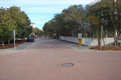
    I distinctly remember Seaside from The Truman Show as well coiffed and manicured. Homes all behind picket fences. When we strolled the streets, the landscaping between each home and white picket fence was overgrown, making it difficult to see the homes and closing up space along the streets. There were no walks along the streets. There were natural trails in a straight pedestrian system behind each home along the rear yards, with paths so narrow (about 4’ between picket fences) that I needed to follow behind my wife as we strolled through the blocks (these paths were not in the movie).

    Many of the homes had observation towers hovering over the rooftops, cool architectural features that would allow a view of the shoreline. A decade after the development’s premiere, that open view was closed up by a wall of very large ocean view homes, blocking all those great views that the towers would have provided. There’s now little tie from the community to the shore other than a single bar elevated above the shops allowing a good view.

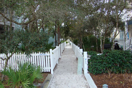
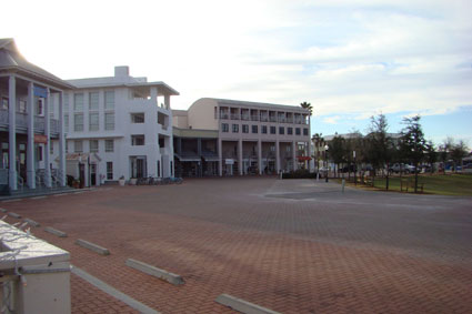
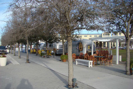
    In general, much of Seaside is overgrown with landscape that blocks the feeling of space. We were told by a few sources that only about twenty residences have full time owners, with the rest rented. There were a few restaurants and bars, and the same grocery store that was in The Truman Show, but the feel of the development was much different than what I expected after seeing the movie. The main street has rows of Airstream trailers with street vendors selling various food items, something I found distracting from the image of New Urbansim; very touristy. The general pattern of Seaside is quite maze-like, requiring us to carry a map as we took a stroll.

    By contrast, WaterColor has similar architectural character, but is much more diverse in its open spaces and provides the look of Seaside with a more suburban sense of space. Seaside homes generally lacked vehicle storage or protection from the elements; WaterColor homes had the convenience of garages — mostly, but not all, in alleys — and some carports. Garages are an indication of permanent residence, not a weekend jaunt. They keep many of the cars off the street and out of sight. Unlike a standard New Urbanism design that separates the garage from the home (as if a car contained some negative aura that could take control of our lives), the WaterColor homes had the garages attached. WaterColor is a place you can live in, not just rent for a week.

    If the nation’s suburban architectural character has improved, I think much of it is due to the effort that Duany has taken to showcase New Urbanism, which has had a positive influence in the overall character of land development. Whether New Urbanism thrives or it fails, he has left us this lasting gift. Duany developments I’ve visited are beautiful, even with their flaws and their high priced entry.

    But architecture and landscaping are NOT planning. And here lies the problem. You can take the worst planned neighborhood and showcase it with the Duany style of high quality elements —- his eye for architecture and landscaping —- and it will look great. In a well-planned suburban neighborhood, on the other hand, the display of repetitive garage-grove facades with plain vinyl siding, void of landscaping other than the requisite sod, will look awful. As people drive or stroll through the Duany development, they will naturally say it’s well planned, even if it’s dysfunctional, inefficient, and has a high environmental impact. This is not to say that it necessarily is, but you can’t feel those things from street level. The plain subdivision will be identified as terribly planned, even if the plan is functional and efficient with low environmental impacts.

    I’m not a follower of Duany and disagree with much of his ideology. But I do thank him for making the real world, suburban and urban —- not just the make-believe world of The Truman Show —- a better place.

    Rick Harrison is President of Rick Harrison Site Design Studio and Neighborhood Innovations, LLC. He is author of Prefurbia: Reinventing The Suburbs From Disdainable To Sustainable and creator of Performance Planning System. His websites are rhsdplanning.com and performanceplanningsystem.com.

    Photo: Seaside, Florida’s Post Office — Where they filmed ‘The Truman Show’

  • Green Wash: The Church of Sustainability

    The term green-wash is used to describe something that has been promoted as ‘green’, but is not. Has the term ‘sustainability’ worn out its welcome as well?

    I am a long time adviser to the board of Sustainable Land Development International. Like many other organizations, they market themselves as producing sustainable land developments through new technologies and methods in design. We often use the term “sustainable” in relation to a concept called the “Triple Bottom Line”: People, Planet, and Profit, endorsed by the United Nations in 2007 for urban and community accounting.

    On March 11th, I will have the honor to be the keynote speaker at the California League of Cities conference in Anaheim. When I speak, it is typically on the topic of sustainable solutions. This time, I was astonished to learn that the term sustainability had become green-wash and that I should avoid using it!

    Individual perspectives (or goals or agendas) can easily color the meaning of sustainability. For example, an environmental engineer might want to promote elements of land development that makes his or her career more important and personally satisfying. All of us have personal agendas that make our brief existence on this planet more meaningful, sometimes at the expense of others or even the very thing we are trying to promote. Often we unwittingly become our own worst enemy.

    At one time our firm began a relationship with one of the largest environmental engineering firms. When we spoke to their engineers about reducing pollutants from rain run-off caused by development it became clear that their only agenda was to eliminate, not to reduce, pollutants. Eliminating pollutants on a land development certainly is possible, but would not be in any way financially feasible. This firm had built a reputation and won over some very large non-profit organizations that fueled their success. Surely the engineers had their self-esteem (egos) inflated. If the developments they designed had to be financially viable without huge non-profit subsidies, they surely would have failed — spectacularly. They were artificially sustainable. Our goal was to use their expertise to create methods that would not add a penny to land development costs compared to conventional construction. We believed pollutants could have been reduced somewhere between 10% and 30%, which would have a significant international impact. As we began to work together it became quite apparent that our agendas were much different, and the relationship withered. Their all-or- nothing approach was not a balanced one, nor was it sustainable.

    Nearly two decades ago when I developed “Coving” as a method to design projects, my own ego got in the way of progress. At the time, the New Urban momentum had begun to grow. I aggressively compared the advantages of Coving to the grid form of traditional development as well as to conventional subdivision design. Reducing streets — “Coving” — by 20% to 50% without reducing density in comparison to a traditional grid certainly had benefits, but the attempt to push an agenda by reducing the importance of others agendas does not win friends, and New Urbanism had already won many converts.

    Coving by itself is only a streetscape design method, nothing else. The efficiency of coving opened up new opportunities to create more functional and financially viable development. . Both coving and the traditional grid pattern rely solely on the performance of the developer and builders to construct to a high level of architectural and landscape standards. The New Urbanism expanded upon the traditional grid to include a strict standard that included many details. Coving remained only a streetscape design method, void of these details. In the hands of a substandard developer with builders who cut corners, both Coving and New Urbanism have resulted in some embarrassingly awful land developments, tarnishing both movements reputations. Coving, particularly because of its financial advantages, seemed to attract some of the worst culprits. Unfortunately, in land development the time from concept plan to enough of a built environment to see the “finished” product can be between two and five years. We had become our own worst enemy by focusing too much on the financial benefits of a design method and not enough on other aspects.

    There were still some spectacular developments that resulted, but there was no mechanism in place to assure great neighborhoods. By the end of the 1990’s it was clear that “our agenda” needed to be modified. In an attempt to achieve a more sustainable world, we had concentrated on a singular goal, not a balanced approach. This meant we needed to step back and look at all the elements of land development to create a balanced approach where no one agenda held the others hostage. Ultimately this led to the creation of a comprehensive approach to land development we coined as Prefurbia.

    Land planning today has become like a religion that requires unwavering devotion. But those who embrace only one approach as the ultimate utopian mega-metropolis design to solve all social ills are fools: There is no singular solution for land development. Not the New Urbanism, not Smart Growth, not Prefurbia. Good planning is not about pointing fingers. It is easy to blame the automobile, blame developers, and blame government. But it is up to those people responsible for growth — stakeholders such as the developer, builders, city staff and council — to determine the best possible path that will result in a legacy for future generations instead of a blighted project that served to fill the bank account of the developer.

    It is also up to the stakeholders to investigate and learn the various options available for growth. If a city planning commission or council member does not have the time to learn the different land development options available today, well, they should step down and be replaced by someone who cares.

    All of this brings us back to the term ‘sustainability’. The dictionary defines it as ‘Capable of being continued with minimal long-term effect on the environment’. Here is the problem: The dictionary does not include the long term affect on economics (affordability) and living standards. Did we create something great for the ducks, but an eventual blighted neighborhood, or a gentrified one exclusively for the wealthy?

    My view of how to be sustainable is simple: Do our best to create places that will still be wonderful, livable, affordable, and environmentally responsible for future generations. If we do, we will have created places that will be sustainable, no matter what planning religion we worship.

    Rick Harrison is President of Rick Harrison Site Design Studio and Neighborhood Innovations, LLC. He is author of Prefurbia: Reinventing The Suburbs From Disdainable To Sustainable and creator of Performance Planning System. His websites are rhsdplanning.com and performanceplanningsystem.com.

  • Suburban Design: Square Peg In A Round Hole

    Remember that Fisher Price toy – “Baby’s First Blocks”? It was supposed to teach us one of life’s first lessons: Place a square shape in a square hole, and a round shape in a round hole. We’re supposed to understand this idea before we learn to say our first words, or to walk. Yet in the development of our neighborhoods, we have put that square shape into every hole, no matter what the shape of that hole.

    In past centuries land was primarily developed with one pattern – the grid — because it was simple to calculate the geometry and stake out in the field. No matter what you have read about the “town square” and the advantages of the “grid pattern”, the reason for the grid was simply that it sidestepped the painstaking task of manually calculating the land development plat when curves were involved. Forested areas were routinely clear-cut, and swamps (today’s wetlands) were filled in. Those were the days during which development was straight-forward and simple: develop land while destroying what nature provided on the soil. Natural topography, which is certainly not based upon the grid, was bulldozed into oblivion.

    In the 1960’s, newer forms of site design became commonplace, primarily in the exploding suburban landscape that rose after urban-core riots fueled what was then known as “White Flight”. This newer form of design introduced more curved patterns. Unlike the grid, the occasional curve broke up the monotony, and submitted site plans began to look more interesting. These new patterns were the start of a desire to follow the natural shape of the terrain.

    But in the 1960s we did not have an awareness of the environmental damage of development that we posses today. As automation in computations, drafting, and land surveying technology began to reduce the workload of non-gridded designs, the curved pattern became more commonplace. This transition is easily seen by visiting any city’s land records and looking at the changes in land development patterns of recorded plats since World War II.

    For decades, the curved patterns were designed by individuals who concentrated on density goals by squeezing every hundredth of a foot allowed by ordinance. Curved streets conform to the random contours of nature much better than the grid, and the curved pattern, if correctly designed, can be extremely efficient while delivering connectivity for vehicles and pedestrians. That is, if the land planner knows how to design these systems. But patterns that would harness any delivered vehicular and pedestrian connectivity were not part of the plan. Without concentrating on harnessing the curved patterns to create functional traffic systems, so-called “land planners” — and anyone can still become a land planner simply by adding the term ‘land planning’ to their business card — provided plenty of ammunition to the New Urbanism movement’s attacks on curved design.

    In any case, with the use of curved patterns land development broke away from sole use of the monolithic square shape, and introduced two new primary shapes: An inner pie shaped lot and an outer pie shaped lot. For more than a half century, these three basic shapes have defined the majority of the growth pattern for American development.

    These three basic shapes have been the foundation on which we have built millions upon millions of new homes. We have been placing that square shaped home in the triangular hole as if one of the first lessons we were taught was meaningless. Those toy blocks were supposed to teach us to take advantage of the shapes in life that we are offered. Apparently the architectural community, as well as the building industry, ignored this opportunity, until now.

    Home builders large and small have used the same basic shape, as if all lots were only rectangular. Even homes that have garage snouts and are often anything but rectangular in shape are set by civil engineers with a house “pad” that is based on the square. I’m pretty sure most of these engineers were brought up with the Baby’s First Blocks, or something similar. Forcing a square shape into a triangle shape results in a bigger triangle than need be, or making the square much smaller than necessary. In other words, we have built a quite inefficient world for over half a century.

    In an effort to create a more sustainable world, we are developing new methods to design neighborhoods. Part of the effort to eliminate the tremendous waste in land development has been to reassess architecture as part of the overall function of the neighborhood. This became much more critical as we developed Performance Planning System, which was created to teach sustainable development design methods. It quickly became apparent that there was a tremendous void in the opportunities to incorporate new forms of architecture, especially in developments with curved patterns.

    The square home that fits on the square lot does not offer much real opportunity for change. But the other two basic shapes invite new efficiency and value to the home buyer, critical in this down housing market. Homes that are shaped to fit on the inside of the curve can be wider in the front…much wider. This results in a home that does not have to be as deep, essentially making the rear area useable as well because of extra rear yard depth, while providing the same useable square footage. The extra width makes the garage less prominent, and creates much more viewable area from within the home that looks out on the larger rear yard and the streetscape. The home that’s wider in the front allows a bigger porch area and greater opportunity to tie living areas to the street. Less of the side of the home is exposed, and the streetscape becomes more attractive, enhancing that all-important curb appeal.

    The outer side of a curved shape is the opposite pie shape. In this case we can create a stronger tie to the larger rear yard (the outer curves have larger rear yards than a rectangular lot). Like the inner pie, there is more width opportunity to create a home that maintains a target square footage, yet is less deep, again creating an ever larger useable rear yard.

    Perhaps even more important is that we can use these new patterns either to make larger homes, to create larger, more useable yards, or to create non-rectangular pad shapes that adhere to the letter of the law (ordinance regulations) while gaining density and reducing neighborhood sprawl. Actually we can easily accomplish all three!

    So what do the home builders think? In this down economy there is little opportunity to for trends to develop, but in almost all cases where we have promoted this idea builders have embraced it. These developers have included one of the largest home builders in North America, and one of the most respected in Texas.

    The amount of waste we can eliminate by using the lessons that were supposed to be taught with our First Blocks is enormous. And it comes just in time to give builders that extra edge in today’s tough market.

    Rick Harrison is President of Rick Harrison Site Design Studio and Neighborhood Innovations, LLC. He is author of Prefurbia: Reinventing The Suburbs From Disdainable To Sustainable and creator of Performance Planning System. His websites are rhsdplanning.com and performanceplanningsystem.com.