Author: Wendell Cox

  • Avoiding Housing Bubbles: Regulating the (Land Use) Regulators

    Federal Reserve Chairman Ben Bernacke called for stronger regulation to avoid future asset bubbles, such as the housing bubble that precipitated the international financial crisis (the Great Recession) in an Atlanta speech.

    The Chairman appears to miss the fact that regulation itself was a principal cause of the Great Recession. The culprit, however, was not financial regulation, but rather land use regulation, which drove house prices so high in highly regulated markets. When households that could not afford their mortgages defaulted, the losses were far too intense for the mortgage industry to sustain, and thus the Great Recession.

    This is not to ignore the role of Congress and others, which fueled more liberal mortgage credit, and created the excess and credit-unworthy
    additional demand for home ownership.

    This higher demand, however, was only a necessary, but not a sufficient condition for creating the bubble, which when burst, precipitated the worst economic crisis since the Great Depression. In many markets, there was relatively little increase in house prices relative to incomes, as prices remained at or below the historic Median Multiple (median house price divided by median household income) standard of 3.0. In other markets, however, prices reached from 5 to 11 times incomes.

    Already, a new bubble may be on the way to developing. Even after the huge losses, house prices in California were only beginning to return to sustainable historic levels (3.0 Median Multiple). Since bottoming out, however, prices in California have risen 20%, at an annualized rate greater than that of any bubble year.

    Perhaps the first principle of regulation is understanding what to regulate. In the case of the housing bubble, it was land use regulations themselves that needed to be regulated.
    To avoid future housing bubbles, no more effective action could be taken than to repeal the restrictive land use regulations, without which the last bubble would have been, at most, only slight compared to the destructive reality that ensued.

  • The Decade of the South: The New State Population Estimates

    Much has been made – particularly in the Northeastern press – of the slowing down of migration to the South and West as a result of the recession. But in many ways this has obfuscated the longer term realities that will continue to drive American demographics for the coming decade.

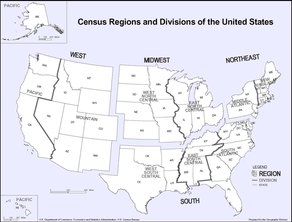
    Americans have been moving from the Northeast and Midwest to the West and South for decades (see US region map). In the first four decades after the Second World War, the warm, dry climates of coastal California were a significant factor. As the nation became more mobile – aided by such things as inexpensive air travel and the interstate highway system and the spread of air conditioning – the larger migration pattern went towards the South. There were, of course, other factors. Business costs, particularly the costs of labor, were often lower in the West and especially the South. Personal taxes in some states were lower than in the Northeast and Midwest. Surely the period from the end of World War II to 2000 could be called the demographic “half-century” of the West and South.

    The New State Census Estimates: The latest (July 1, 2009) Bureau of the Census release of state population estimates indicates a fundamental shift in migration patterns. Yes, even at recession-depressed rates, the Northeast and Midwest continue to export domestic migrants, but they are almost exclusively going to the South now, and not the West (See Table).

    Net Domestic Migration by State
    2009 Rank Net Domestic Migration Rank 2000-2009
    State 2009 2000-2009
    1 Texas    143,423       838,126 2
    2 North Carolina      59,108       663,892 4
    3 Washington      38,201       239,037 9
    4 Colorado      35,591       202,735 10
    5 South Carolina      31,480       306,045 7
    6 Georgia      26,604       550,369 5
    7 Tennessee      20,605       259,711 8
    8 Oklahoma      18,345         42,284 19
    9 Virginia      18,238       164,930 12
    10 Oregon      16,173       177,375 11
    11 Arizona      15,111       696,793 3
    12 Louisiana      14,647      (311,368) 45
    13 Alabama      11,044         87,199 14
    14 Utah        8,623         53,390 17
    15 Wyoming        7,192         22,883 25
    16 Kentucky        6,268         81,711 15
    17 Arkansas        5,298         75,163 16
    18 West Virginia        4,510         17,727 26
    19 District of Columbia        4,454        (39,814) 37
    20 Massachusetts        3,614      (274,722) 44
    21 New Mexico        3,366         26,383 24
    22 Delaware        2,580         45,424 18
    23 Montana        2,410         39,853 21
    24 South Dakota        1,619            7,182 27
    25 Idaho        1,555       110,279 13
    26 North Dakota        1,375        (18,071) 31
    27 Pennsylvania        1,346        (33,119) 34
    28 Alaska           979          (7,360) 29
    29 Missouri          (124)         41,278 20
    30 Nebraska          (956)        (39,275) 36
    31 Vermont          (975)          (1,505) 28
    32 Kansas       (1,242)        (67,762) 41
    33 Iowa       (2,135)        (49,589) 40
    34 New Hampshire       (2,602)         32,588 22
    35 Maine       (2,937)         29,260 23
    36 Nevada       (3,801)       361,512 6
    37 Hawaii       (5,298)        (29,022) 33
    38 Mississippi       (5,529)        (36,061) 35
    39 Wisconsin       (5,672)        (11,981) 30
    40 Rhode Island       (6,172)        (45,159) 38
    41 Indiana       (6,805)        (21,467) 32
    42 Connecticut       (7,824)        (94,376) 42
    43 Minnesota       (8,813)        (46,635) 39
    44 Maryland    (11,163)        (95,775) 43
    45 Florida    (31,179)    1,154,213 1
    46 New Jersey    (31,690)      (451,407) 47
    47 Ohio    (36,278)      (361,038) 46
    48 Illinois    (48,249)      (614,616) 49
    49 Michigan    (87,339)      (537,471) 48
    50 New York    (98,178)  (1,649,644) 51
    51 California    (98,798)  (1,490,105) 50
    Derived from US Bureau of the Census data.

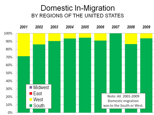
    Moving to the South: Between 2000 and 2009, the South attracted 90% of domestic migrants from other states, with the West accounting for only 10% (see chart below). In 2001, the South attracted 71% of domestic migration but its share rose to 86% in 2002 and accounted for virtually all net migration by 2007. In that year, not only did the Northeast and Midwest lose domestic migrants, but also the West. By 2009, the South’s share of inbound domestic migration fell back to 94%.

    Throughout the decade, the small share of domestic migration that did not go to the South went to the West, while the Northeast and Midwest continued to lose residents. The 2000s are best characterized as the demographic “decade of the South” because the vast majority of Americans moving between states moved South.

    Nearly all states in the South gained domestic migrants during the decade. Only Mississippi, Maryland and Louisiana, along with the District of Columbia, lost domestic migrants. Even before Hurricanes Katrina and Rita, Louisiana was losing domestic migrants. Perhaps the big surprise is Florida, which has led the nation in domestic in-migration for years and has attracted 1.1 million from other states during the 2000s.

    Florida’s peak came in 2004 and 2005, when more than a net 260,000 domestic migrants moved to Florida from other states. Things have changed markedly, however, with Florida rapidly losing domestic migrants in 2008 and 2009, very likely due to the impact of the housing bubble and an overreliance on inbound retirees to drive its economy.

    However, Florida’s recent decline does not weaken the near-monopoly position of the South as the dominant destination of movers. Florida’s rapidly declining domestic migration has been largely replaced by a new domestic migration champion: Texas. In the early 2000s, Texas generally attracted from 30,000 to 50,000 net domestic migrants. Migration from Louisiana from Rita and Katrina propelled Texas to the top in 2006 and the state appears to have consolidated its position as the leader in domestic migration. In 2009, with domestic migration at more modest levels nationally, the Texas gain was more than any year except for 2006 with Hurricanes Katrina and Rita. But it’s not just a Lone Star story. Seven of the top ten states in domestic migration remained in the South in 2009. Throughout the entire decade, 6 of the top 10 states were from the South and 4 from the West. However, most of the gains in the West were simply from moving around (and from California); there was relatively little inter-regional domestic migration.

    Moving Around the West (and Away from California): Most states in the West have also gained domestic migrants in the 2000s, with the exceptions of Alaska, Hawaii and California. California is the real story in the West, having lost nearly 1.5 million domestic migrants, a population greater than that of the city of San Diego. In 2000, California lost nearly 100,000 domestic migrants and for the fourth year in a row led the nation in net domestic out-migration. This includes 2006, when not even Louisiana’s catastrophic hurricanes could drive as many people away as California. During the first year of the decade, California lost only 45,000 net domestic migrants. By 2007, as the center of the worldwide housing bubble, California’s losses were 7 times that amount. In 2009, even with depressed migration rates associated with the recession, out migration more than doubled between 2001 and 2009.

    California is simply not the draw that it used to be. There was a time, in the late 1930s, that the state tried to bar “Okies” from moving to the state, legislation wisely declared unconstitutional by the Supreme Court. Things have certainly changed. The latest Internal Revenue Service data indicates that every year during the 2000s, Oklahoma gained net domestic migrants from California.

    Outside California, there has been healthy domestic in-migration in the West. However, California’s losses cancelled out more than 80% of the West’s gains during the decade. Much of the movement within the region was internal, with Californians shifting to markets where housing was less expensive (but still expensive), such as Arizona, Nevada, Washington and Oregon. More recently the movement to the housing bubble ground zero states of Arizona and Nevada, have all but disappeared, with far smaller gains in Arizona and a small net loss in Nevada in 2009.

    In one year (2007), California lost more domestic migrants than all of the other states of the West gained. Domestic migration in the West remains largely about households moving around within the region: from California to other states, with a far smaller number arriving from elsewhere in the nation.

    Escape from New York (and the Northeast): Domestic migrants continue to leave the Northeast, just as they have for decades. In the Northeast, only New Hampshire and Maine gained domestic migrants in the 2000s. However, it was a bit different in 2009. Both New Hampshire and Maine lost, while Massachusetts and Pennsylvania gained.

    Pennsylvania has been the subject of more than one “what’s wrong with Pennsylvania” report as analysts inside and out decry its competitive position. In fact, by the ultimate measure of competitiveness, where people choose to move to or from, Pennsylvania has done relatively well in the 2000s. Pennsylvania’s modest loss of 33,000 domestic migrants pales by comparison to the net 2.5 million people who have moved away from neighboring New York, New Jersey, Maryland and Ohio. Like Texas, Georgia and many other states, Pennsylvania largely missed the housing bubble, which probably accounts for some of this surprising phenomenon.

    But the relative success of Pennsylvania should not be touted, as the mainstream media would tend to, as a sign of general Northeastern resurgence. New York alone lost 1.65 million over the 2000-2009 period. This is, in absolute numbers, more than California and a larger percentage loss than Louisiana with Katrina and Rita. Critically, data through 2008 shows that most of the domestic migration losses came from New York City and to a lesser extent its suburbs. Upstate New York, which also missed the housing bubble, experienced comparatively modest domestic migration losses, as Ed McMahon and I showed in an Empire Center policy report earlier this year.

    Hollowing out the Heartland: Domestic migrants are also deserting the Midwest, though in somewhat smaller numbers than in the Northeast. Only Missouri and South Dakota gained domestic migrants in the 2000s, although in 2009, Missouri experienced a small loss and was replaced by North Dakota as a gainer. But it is not a region-wide phenomena. Nearly 90% of the loss in the Midwest was in Illinois and the economic basket case states of Michigan and Ohio.

    Slowing Migration: One of the principal stories out of this year’s Census release is that interstate domestic migration declined markedly in 2009. Indeed, domestic migration was lower than in any other year in the decade, but not by that much. In 2009, 500,000 people migrated between the states, compared to between 570,000 and 620,000 annually from 2001 to 2003. Then, from 2003 to 2007, interstate domestic migration was up to 1.25 million and averaged more than 900,000. The anomaly is not so much that domestic migration is down, but rather that domestic migration got so high in the middle part of the decade, at the very same time that house price differences reached unprecedented heights. It’s no wonder people were moving.

    The Future? What comes next after the chaotic decade of the 2000s? As is suggested above, much of the variation in domestic migration is explained by differences housing prices and trends. Indeed, the price of housing may be a surrogate for the cost of living, which varies principally between areas based upon housing cost differences. This is likely to continue. In coastal California, house prices remained above historic norms, even at the largest “bubble burst” losses,” and there are recent indications that unhealthy price escalation has resumed. Much of the West and most of the country is far more affordable. This would suggest that coastal California’s domestic migration losses will continue and rise in the future.

    By contrast, in much of the rest of California and the other “ground zero” states of Florida, Arizona and Nevada house prices have returned to historic norms, which suggests that after the recession, strong domestic in-migration could resume.

    The future looks very bright for Texas and other states in the South that have done so well (such as North Carolina, South Carolina, Georgia, Tennessee, Oklahoma and even Arkansas). Their biggest challenge will be to resist the siren songs to become more like California, with its disastrous policies appreciated only by proponents and a fawning media.

    Wendell Cox is a Visiting Professor, Conservatoire National des Arts et Metiers, Paris. He was born in Los Angeles and was appointed to three terms on the Los Angeles County Transportation Commission by Mayor Tom Bradley. He is the author of “War on the Dream: How Anti-Sprawl Policy Threatens the Quality of Life.

  • World Small Area Map of GHG Emissions

    The European Commission has just made a Google Earth overlay available showing annual greenhouse gas (GHG) emissions by 10 square kilometer quadrants. The overlay can be manipulated to show estimates from every year beginning in 1970. One of the most fascinating features is the GHG emissions on the oceans, from shipping lanes. All are green (fewer GHG tons), but one route stands out as by far the busiest, from Hong Kong and Japan through the Straits of Malacca and the Suez Canal to northern Europe.

    The application is useful for broad reviews of GHG emissions by same-sized areas, though the zoom feature does not provide high resolution enough photography to discern differences at the smallest area level.

  • The Suburbs are Sexy

    The Administration’s Anti-Suburban Agenda: Nearly since inauguration, the Administration has embarked upon a campaign against suburban development, seeking to force most future urban development into far more dense areas. The President set the stage early, telling a Florida town hall meeting that the days of building “sprawl” (pejorative for “suburbanization”) forever were over. Further, a number of bills have been introduced in the Congress that would attempt to discourage suburban development, some under the moniker of “livability,” which promises to improve people’s lives by enforcing planner-preferred density. The war against the suburbs is by no means new, but the Administration and some members of Congress have proposed their own “surge” in hopes of suppressing them permanently.

    The Mythical “Demise” of the Suburbs: Nearly since the pace of suburbanization increased, following World War II, critics have been foretelling the demise of the suburbs. During the 1950s and 1960s, some planning “visionaries” such as Peter Blake were predicting widespread municipal bankruptcies in the suburbs and for residents. This was occurring even as other urban planners were tearing up cities with urban renewal projects and freeways, setting the stage for “block-busting” and an ever-widening racial divide. The early criticisms have been repeated through the years, justifying a paraphrase of the old saw about Brazil (“Brazil is the country of the future and always will be”): “The suburbs are the wasteland of tomorrow and always will be.”

    The Real Decline of the Cities: In fact, it has more generally been the central cities that nearly went bankrupt, not the suburbs. Examples include New York, Philadelphia, Pittsburgh, Cleveland and that jewel of municipal consolidation, Indianapolis, rescued last year by $1 billion in state taxpayer funds. There are hopeful signs of a renaissance in most central cities, however their financial difficulties remain intractable and large swaths of their land area remain desolate. Meanwhile, the lawns were mowed in the suburbs, the houses painted and a strong sense of community developed among residents that was far too subtle for the prophets of suburban doom to perceive.

    Greenhouse Gas Emissions: More recently, the effort to reduce greenhouse gas (GHG) emissions has given suburban critics new ammunition. A simple mantra was dictated by “planning common sense.” Cars produce greenhouse gases, therefore people must get out of cars and live in more dense conditions, where they will not need to drive as much. Further, they will live in smaller, multi-family dwellings, which planning common sense teaches are more GHG friendly than the despised – except by those who choose to live in them – detached housing in the suburbs.

    But a funny thing happened on the way toward GHG inspired desurburbanization. Some academics actually began looking at data. The reality of the suburbs turned out to be rather different from that portrayed by the conventional wisdom of the planners. The most comprehensive research comes from Australia, some of which has been previously covered here.

    University of South Australia: The most recent (and new) offering comes from a University of South Australia report thatallocates transportation and residential energy produced GHGs by location and housing type in the Adelaide area. The researchers found that the most GHG friendly sector of the urban area was the inner suburbs, which are dominated by single-family attached housing. GHG emissions per capita from housing and transportation were estimated at 7.0 metric tons of GHG emissions per capita annually.

    However, the outer suburbs, principally with detached housing, were not far behind at 7.4 tons GHG emissions per capita. The highest GHG emissions per capita, by far, were in the central area, with its predominance of multi-unit housing. There the annual GHG emissions were estimated at 10.0 tons per capita (See Figure). The University of South Australia study includes an element missing from virtually all other examinations of transportation and residential GHG emissions: “embodied emissions.” Embodied emissions are the GHGs from construction or manufacturing materials, and from building cars, transit vehicles and buildings. Embodied GHG emissions are ignored by much research, but are a significant factor in GHG emissions. For example, multi-unit housing, with higher use of concrete and more complex construction methods, tends to be substantially more GHG intensive than building detached housing or townhouses.

    GHGs from Common Energy: Previous work by Sydney researchers reached similar results – townhouse development was the most GHG friendly, followed closely by detached housing. Both were substantially less GHG intensive than high-rise condominium development. A principal reason for this conclusion stems in part from the fact that this research included GHGs from common energy, such as the electricity used to power elevators, parking lot and common area lighting, building-provided heating, air conditioning and water heating. American and Canadian research attempting to quantify GHG emissions by residential building type generally has not accounted for common energy and its GHG emission. Yet a gram of GHG from a residential elevator has the same impact as one produced by driving to the local Target store.

    GHG Friendly Suburbs: The most comprehensive research was conducted by the Australian Conservation Foundation. This was not the typical, incomplete or theoretical study of greenhouse gas emissions. The study included virtually every gram of greenhouse gas emissions in Australia and allocated them to consuming households in small residential zones within urban areas and around the nation. Suburban locations, with their greater use of cars and higher percentage of low density detached housing, had lower GHG emissions per capita than the core areas, with their greater use of transit and walking and their high-rise multi-unit housing.

    Compact Development: These findings provided the impetus to review the potential impact of compact development policies. Compact development policies (also called “smart growth” or “growth management”) generally seek to densify urban areas, by drawing urban growth boundaries, outside of which development is prohibited, and by trying to force people to drive less and to use transit more. Again, “planning common sense” clearly indicated to planners that compact development would yield substantial benefits in GHG emissions, principally because people would drive less.

    Yet the more recent research on compact development finds something much different. Densification scenarios from two recent reports, the congressionally mandated Driving and the Built Environment and a smart growth coalition’s Moving Cooler, showed that by 2050, compact development could reduce GHG emissions from driving by only 1% to 9%. At the high end of the range, the most new development would be directed to only a small part of present urban footprints, a policy outcome less believable than a balanced federal budget next year.

    Moreover, these projections have to be considered overly optimistic, because they make no allowance for the higher GHG emissions that occur as traffic slows and stops more in higher density conditions.

    The President Discovers the Suburbs? Meanwhile, on December 15, President Obama took the opportunity to visit a suburban Washington Home Depot, a chain that is a very symbol of American suburbanization. The President could have taken the opportunity to orate further against the suburbs in the insulation aisle, urging households to abandon the suburbs and move to high rise condominiums in the city.

    That was not to be. The President instead proposed providing incentives to people to make their houses more energy efficient, which would reduce greenhouse gas emissions and save money on consumer energy bills. In particular, he cited insulation, saying that “insulation is sexy”. It is worth noting that the Home Depot’s insulation is principally sold to suburban homeowners who can readily arrange for its installation. Residents of high-rise condominiums must rely on their building managers, who tend to purchase their insulation from wholesalers, rather than retailers like Home Depot and Lowes.

    The President explained why insulation was sexy, noting that saving money is sexy. Indeed, saving money is what the suburbs are about. The economic research is clear that housing costs are far less where suburban development is not limited by the compact development strategies that artificially create land scarcity. That’s why places like Dallas-Fort Worth, Atlanta and Houston, without compact development, had little, if any housing bubble, while housing bubbles of economy-wrecking proportions occurred in California and Florida, with their compact development.

    Yes, Mr. President, insulation is sexy. Saving money is sexy. And, the suburbs are sexy.

    Wendell Cox is a Visiting Professor, Conservatoire National des Arts et Metiers, Paris. He was born in Los Angeles and was appointed to three terms on the Los Angeles County Transportation Commission by Mayor Tom Bradley. He is the author of “War on the Dream: How Anti-Sprawl Policy Threatens the Quality of Life.

  • Obama Credit for Bush Fuel Efficiency Improvement

    The press’s love affair with President Obama goes so far as to give him credit for actions of his predecessor, George W. Bush. Over the last week, the New York Times and The Guardian,
    Britain’s “quality leftist daily gave the President credit for working out a deal with auto makers to improve fuel efficiency by 30%.

    Not quite. The Obama Administration worked out a deal with the automakers under which they would not sue if the already approved 2020 fuel efficiency standards were advanced to 2016. In fact, the 30% improvement, which was in the 2020 standards, was passed by Congress in 2007 and signed by President Bush.

    This is not to deny credit to President Obama for working out the agreement with the auto industry that removed the possibility of legal challenges to advancing the Bush 30% improvement by 4 years. The government’s substantial financial stake in General Motors and Chrysler probably helped seal the deal.

  • “Planning Pool:” Length of Year Increases 800% in 2008 from Previous Year?

    The Canadian planning blog “Planning Pool” congratulated the Charlotte, North Carolina light rail line, noting that it “experienced an 800% increase in ridership last year” (“Transit Success in Sprawl City,” December 4).

    The impressive increase was made possible by comparing apples and oranges. Last year (2008) the Charlotte light rail service operated all year, while in the previous year (2007), service operated fewer than 40 days (the line opened in late November). Following its logic, the “Planning Pool” missed an even bigger story: apparently 2008 was 800% longer than the previous year (an increase from fewer than 40 days to 365).

    Of course, it’s either apples or oranges and, one way or the other, a revision is in order.

  • DUBAI: A High Stakes Bet on the Future

    I picked up a copy of The Wall Street Journal-Europe on the concourse while boarding my Emirates Air flight from Paris to Dubai. The lead story provided an unexpected relevance to the trip – my first to Dubai. Dubai World, owned by the Dubai government, had announced a 6-month moratorium on payments of some of its $60 billion in debt. Since the announcement, stock markets have been dropping and recovering, company officials have attempted to calm borrowers and government officials have provided considerably less assurance than Dubai’s investors would have preferred.

    Here’s a brief guide to Dubai and some thoughts about its future.

    The United Arab Emirates: Dubai is one of the seven emirates of the United Arab Emirates (UAE), which like the United States and Canada is a federation. Broadly speaking, the emirates represent states or provinces. By far the richest is Abu Dhabi, with something like 10% of the world’s oil reserves. Just 100 miles up the eight-lane freeway is Dubai, with little in oil reserves, but which has used its previous income and massive borrowings to create one of the most spectacular urban environments in the world.

    An Architectural Feast: Dubai is a feast of modern high-rise architecture on shore, off shore and in man-made islands shaped like palms and a map of the world. A tour of the world’s most spectacular modern high-rise architecture could take many trips to China, including Shanghai’s Pudong, the developing western downtown of Beijing, the transforming core of Nanjing, around north station in Shenyang and the world’s largest boom-town, Shenzhen. But Dubai provides nearly as impressive a list of attractions within a comparatively few square miles.

    The Burj: Soon, the new world’s tallest building will open in Dubai. The Burj is virtually complete, with 160 floors and rising nearly 2,700 feet or more than 800 meters. The Burj is more than twice the height of the Empire State Building and a full 60% higher than the previous world record holder, Taipei 101. Adjacent to the Burj is Dubai Mall, which when completed will be the largest in the world. Another Mall, Emirates Mall, has an indoor ski area, a rather unique feature for the desert.

    The Main Street Freeway: The main thoroughfare in Dubai is Sheikh Zayad Road, a 12-14 lane freeway, with additional service lanes on both sides. On either side, there is a row of some of the world’s tallest buildings, often not more than a few feet apart. Except in the Burj area, the tall buildings tend to be in single rows, with low rise development beginning virtually at the rear lot lines.

    Dubai’s Upper North and South Sides: Manhattan has its upper east and west sides, while Dubai has its upper north and south sides. It is an open question which is more impressive, but if all of the planned construction is completed, Dubai’s skyline will overshadow that of New York. On the north side of Sheikh Zayed Road, there is the Dubai Marina, which played prominently in press reports expressing concern about the debt moratorium. Much of the Dubai Marina is still under construction. On the north side of Sheikh Zayed Road there is another development that appears to be at least as large as Dubai Marina, Jumeirah Towers, with many buildings still under construction. These two developments line the freeway for two miles and stretch at least 0.5 miles in each direction from the freeway. There are twin towers that appear to be generally modeled on New York’s classic Chrysler Building just to the east of the Marina on Sheikh Zayed Road. However, uncharacteristically for Dubai, they are not as tall.

    The Palms and the World: Some of the most spectacular architecture is just to the west of the Marina, in and around the Palm Jumeirah Island (actually four islands). The Palm Jumeirah is home to the Atlantis Hotel, which would be the talk of any town in the world, except Dubai, that is. The Jumerirah Palm island includes single family housing on its “fronds” and high rise condominiums at the entrance. A monorail operates, largely empty, to the Atlantis Hotel from the mainland, though does not connect to the Dubai Metro.

    The developer of the Palms and a group of islands called “The World” (in a shape somewhat like the world) is Nakheel, a subsidiary of Dubai World. This subsidiary was the unit that first indicated it would not be able to meet its financial obligations on time

    Burj Al Arab Hotel: Just to the east of Jumeirah Palm is one of Dubai’s oldest and best known architectural masterpieces, the Burj Al Arab Hotel, which sits offshore, though not at the distance many of the publicity photos suggest. This is a prehistoric structure by Dubai standards, having opened in 1999.

    Ring Roads and the Silicon Oasis: Dubai has two incomplete ring roads. The inner ring (Route 311 or “Emirates Road”), 12 lanes, runs through partially developed desert. The outer ring (Route 611), which is up to 10 lanes, runs through even less developed desert. There are, nonetheless, interesting projects along both roads. Dubai’s Silicon Oasis contains massive commercial buildings, still under construction, high rise condominium buildings and single family housing, which is behind security. This impressive development would be illegal in virtually all Australian urban areas, all of the UK and some US urban areas, because it would lie outside the urban growth boundaries that have been imposed by planners in those places.

    Academic City: On the edge of Silicon Oasis lies the Academic City, which contains branches of universities such as Murdoch (Perth, Australia) and Michigan State. Perhaps someday there will be an annual gridiron or soccer match played between the two in the nearby new Cricket Stadium nearby the Academic City.

    The Urban Area: The Emriate of Sharjah is to the immediate east of Dubai and continues the urbanization for many miles. The urban area (containing both Dubai and Sharjah) has approximately 2 million people. This is a very small population (less than that of Sacramento or Portland) for an urban area of such world significance and monumental architecture.

    The Dominant Ethnic Minority: The native or citizen population of “Emiratis” is much smaller, estimated at under 20%. The balance of the population is primarily expatriate workers who are in Dubai on temporary visas. So long as the hundreds of thousands of Indians, Pakistanis and others have employment, they can stay.

    Future Plans: Dubai has every intention of continuing its building binge. Already, a huge new international airport is under construction, which will have an annual capacity as much as 50% greater than the world’s largest airport (Atlanta). Unbelievably, the present airport, which has had significant recent expansion, would remain open. The two airports together would provide Dubai with more passenger capacity than the five airports of Los Angeles (with its 18 million consolidated metropolitan area population). There are many more hotels, large condominium and residential projects on the drawing boards. There are plans for a luxury hotel under water.

    Projects on Hold: However, Dubai may not be the master of its own fate. The UAE and the Emirate of Abu Dhabi, both with much more in financial resources, are expected to provide Dubai some relief. However, any assistance will come at a price. Control of crown jewel “Emirates Airlines” could be lost. The new international airport could be put off, particularly with nearby Abu Dhabi also expanding its airport

    The question is whether Dubai can rebound. There are plenty of uncompleted projects like the “City of Arabia” development along the Emirates Ring Road, far from the core. The project’s website says it will be completed in 2008. It is nearly 2010, and to put it mildly, from Emirates Road, the project appears to be a bit behind schedule.

    The undersea hotel project also appears to be on hold. The proposed Nakheel Tower could rise to over 4,000 feet and would be located just to the east of Jumeirah Towers. It was, however, put on hold in early 2009. Nakheel, of course, is at the heart of the Dubai financial crisis. Construction has apparently stopped on Nakheel’s Deira Palm (the largest of the palms) and the World.

    Of course, Dubai is not the only place where financial difficulties have put buildings on hold. Chicago’s “Spire” is little more than a circular hole next to Lake Shore Drive, rather than a rapidly rising edifice that would have been the world’s second tallest tower, after Dubai’s Burj.

    Whither Dubai? It seems fair to ask what Dubai was seeking to accomplish. On one hand, there was an interest in developing a strong tourism base, and tourism has increased over the past decade. Yet, Dubai attracts only 1/10th of tourism of Las Vegas, while having more than one-half the hotel rooms. One challenge is that what has been built may already be too large to be supported by the permanent population, Emirati or expatriate.

    But the real question is where Dubai goes from here. Late reports indicate that Dubai World intends to restructure nearly one-half of its debt. Creditors had hoped that the richer Emirate of Abu Dhabi would bail out Dubai, not much different from Texas bailing out a virtually bankrupt California. The more likely possibility could be that the UAE federal government itself might guarantee some debts but neither seem in any hurry to provide blanket relief. This could be reflective of the growing revulsion to the massive government bailouts from the Great Recession.

    At this point, the international repercussions appear unlikely to be large enough to start phase II of the Great Recession. Yet the notion of providing a safe “haven” in a tough neighborhood could still pay off in the long run as it has for cities like Singapore. It may not be conventional wisdom to say this, but the Emiratis could end up with the last laugh.

    Top photograph: Dubai Silicon Oasis
    Second Photograph: The Burj (November 27, 2009)

    Wendell Cox is a Visiting Professor, Conservatoire National des Arts et Metiers, Paris. He was born in Los Angeles and was appointed to three terms on the Los Angeles County Transportation Commission by Mayor Tom Bradley. He is the author of “War on the Dream: How Anti-Sprawl Policy Threatens the Quality of Life.

  • The Fed and Asset Bubbles: Beyond Superficiality

    There is considerable discussion about tasking the Federal Reserve Board with monitoring and even taking actions to prevent asset bubbles. Before they move too far, the Fed needs to understand what happened in the housing bubble to which they responded after the world economy was decimated.

    Any initiative on the part of the Fed to seriously understand, much less do anything about asset bubbles requires that their causes be comprehended at more than a superficial level. To this day, the Fed appears to presume that the housing bubble was simply the result of financial factors, such as loose money and loose lending. In fact, however, the housing bubble was far more complex than that.

    The averages on which the Fed and much of the business press have based their analysis hide the dynamics that were at the heart of the price explosion. The housing bubble inflated with a vengeance in only one-half of the major US metropolitan markets, and inflated very little in the others.

    There is no doubt that the bubble would not have occurred without the loose monetary policies. However, where the bubble inflated the most, it was in a metropolitan environment of excessively strong land use controls or artificially constricted land supply (called compact development or smart growth). In these markets (such as in California, Florida, Phoenix, Las Vegas, Portland and Seattle), regulation is so strong that when the loose credit induced expansion of demand occurred, the housing market was not permitted to respond with a supply of new affordable housing, and there was a rush to purchase existing stock, which drove prices up.

    On the other hand, in the traditionally regulated markets, including fast growing metropolitan areas like Atlanta, Dallas-Fort Worth and Houston, there was comparatively little escalation in house prices. In short, one-half of the country had a housing bubble, the other half did not. In the more highly regulated markets, the Median Multiple (median house price divided by median household income) increased to from 4.5 times to more than 11 (compared to the historic ratio of 3.0). In the traditionally regulated markets, the 3.0 standard was generally not exceeded. Thus, as Nobel Laureate Paul Krugman of Princeton University and The New York Times noted more than three years before the crash, the United States was really two nations with respect to house price escalation, and the difference was land use regulation.

    We have estimated that the house value losses were overly concentrated in the compact development markets, accounting for 85% of the peak to trough declines. Without these artificial losses, which were the result of unwise policy intervention, the international Great Recession might not have been set off or it certainly would have been less severe. All of this is described in the last two editions of our “Demographia International Housing Affordability Survey” and related items (the 6th Annual Demographia Housing Affordability Survey will be available early in 2010).

    The purpose of compact development and smart growth is to stop the expansion (the ideological term is “sprawl”) of urban areas. Clearly, given the distress that has occurred in the US housing market and the wave of additional losses in both the domestic and international economy that followed, the price of stopping urban expansion (or attempting to) has proven to be immensely larger than any gains.

    At least in housing, until the Fed understands what happened, it will be powerless to effectively apply whatever new powers it employs to control future housing bubbles.

  • The Infrastructure Canard

    One of the principal arguments used against suburbanization is that its infrastructure is too expensive to provide. As a result, planners around the high income world have sought to draw boundaries around growing urban areas, claiming that this approach is less costly and that it allows current infrastructure to be more efficiently used.

    Like so many of the arguments (a more appropriate term would be “excuse”) used to frustrate the clear preferences about where people want to live and work, the infrastructure canard holds little water upon examination.

    Becoming Less Affordable as Demand Declines: Within the new world high-income nations, there was considerable urban growth between World War II and 1980. Nearly all of this growth was in the suburbs, where infrastructure was provided through borrowing, taxation and utility user fees. Yet, even as population growth has slowed, the diminished bill has been declared beyond the capability of governments which have often opted for what is seen as more affordable compact development (smart growth).

    Estimating the Cost of Suburban Infrastructure: The seminal volume Costs of Sprawl – 2000 projected a need for $225 billion more in costs from 2000 to 2025 for expanding suburban infrastructure than would be required for more compact development. This superficially large number melts down to $30 per capita on an annual basis. This is hardly the kind of expenditure increase that brings bankruptcy to local governments, even if it were not disputable.

    Higher Cost Infill Infrastructure: Costs of Sprawl – 2000 and other analyses generally rely upon a “build up” of infrastructure costs, which is then extrapolated to develop overall estimates. These estimates are rarely, if ever, calibrated for consistency with actual experience as reported in government financial sources. Moreover, they generally assume that the cost of building comparable lengths of sewer, water or roads are equal throughout the urban area. They are not. Generally, costs are far higher in infill areas, for a variety of reasons, especially higher labor costs.

    Public and Private Costs: Further, many of the infrastructure costs decried in Costs of Sprawl – 2000 and other sources, are not government costs at all but incurred by private companies. Virtually all local roads and some arterials are built and paid for by developers, with the costs passed on to homeowners. Sewer and water expenditures are usually financed by user fees, either paid to private companies or municipally owned utilities.

    Cost Differences are Minimal: Moreover, my analysis with Joshua Utt of municipal water and sewer user fees from all reporting jurisdictions in 2000 indicated a 1,000 increase in population per square mile is associated with a $10 reduction per capita, a figure that does not justify strong-armed land use regulation.

    The High Cost of Infill Infrastructure: Proponents fail to account for the fact that infill development also requires more infrastructure. The existing water and sewer systems in densifying areas are likely to require upgrades, now or later. In many older cities, these systems are older, even obsolete and may not have the capacity to meet the increased demand. Constructing these upgrades will generally be far more expensive in an already developed area than building new, state of the art facilities in greenfield areas.

    Building Gridlock: The proponents virtually never propose expansion of roads to deal with the increased traffic that occurs in densifying conditions. Yet, the national and international evidence is clear: higher densities produce more traffic. Without more capacity, this means slower speeds, more intense pollution and more greenhouse gas emissions.

    There is no point in imagining that it can be any different. For example, the most dense part of the nation is New York’s Manhattan. It is served by a rail system that is far more comprehensive than any other place in the nation. Yet, traffic volumes (total vehicle miles) per square mile in Manhattan are more than 3.5 times that of the nation’s most congested urban area, Los Angeles, and 12 times that of the nation’s least dense major urban area, Atlanta.

    Thus, any savings that might be obtained from not expanding roads to meet demand is achieved by retarding service levels. Further, the longer travel times would stunt economic growth.

    The Transit Infrastructure Canard in Australia: One of the more ludicrous features of the infrastructure canard in Australia is the fixation with rail transit, which planners frequently justify to ban or limit suburban expansion. This is a Neanderthal view that fails to recognize that only a small portion of urban fringe dwellers work in the downtown areas, which are the only employment centers effectively served by rail. The minute roads are opened, the infrastructure for transit is in place. Bus service can quickly and efficiently be established to downtown, local employment poles, or the nearest rail station for those few outer suburbanites who can get to work more conveniently by transit than by their cars. Overall, less than 20% of commuters work downtown in Australian urban areas, and the farther out they live, the less likely they are to commute downtown.

    Operating Costs are the Problem: Moreover, the focus on construction of new facilities is misplaced, because, construction costs are not the principal driver of public expenditures. Less than 20% of local government expenditures are for construction, while more than 80% covers day to day operations. New population, or the same population in a larger area will require similar government operating expenditures. It is likely that compact development will require just as many teachers and just as many public servants. Moreover, they will probably be paid more, since older, more dense communities have significantly higher government employee wages and salaries per capita than average.

    Cost Consequences of the Infrastructure Canard: More importantly, the infrastructure canard imposes far greater costs on society than any savings even its most ardent proponents can imagine. This is because compact development materially increases housing costs.

    Destroying Housing Affordability in Australia: There’s ample evidence of this down under. Planners have tied a noose around all Australian urban areas which virtually outlaws development on or beyond the urban fringe. As economics would predict, land for development has become scarce, which in turn has increased its price. Once known for its affordable housing, most Australian areas have seen the price of homes relative to incomes double or triple since the new policies were enacted. Nearly all of this increase has been in the price of the land, not in the house construction (inflation adjusted). Land for development is so scarce in this less than 0.5% developed nation that its urban areas are likely to be buried by blizzards before housing affordability returns.

    Destroying Housing Affordability in the United States: In the United States, compact development polices have also increased house prices. For example, even after hitting bottom earlier this year, house prices in compact development markets such as California, Seattle and Portland remained as much as twice as expensive related to income than in less strongly regulated markets. The annual US infrastructure savings suggested in the Costs of Sprawl – 2000 are so small that they would pay less than one-third of the excess higher annual mortgage payments in California attributable to compact development (Note).

    Fastest Growing Metropolitan Areas: Doing the Impossible: While planners in California, Portland, Seattle and elsewhere delude the public and elected officials into believing that suburban infrastructure is unaffordable, faster growing metropolitan areas found the opposite. Atlanta, Dallas-Fort Worth and Houston are the three fastest growing metropolitan areas with more than 5,000,000 population in the high income world. Rather than restraining suburbanization, these metropolitan areas allowed it to continue. Their reward was not only delightful communities (despite their being despised by the planners), but also the retention of housing affordability. None of this has slowed some positive inner-ring development, particularly in Houston, to meet that niche demand.

    A Matter of Will: The fast growing metropolitan areas demonstrate that suburban infrastructure can still be provided without a material financial burden to the community. Indeed, given the house price escalating effects of compact development, the cost of living will be lower where suburban expansion is allowed. It is not a matter of suburban infrastructure being too expensive but the resistance of planners and urban land autocrats to crafting policies that actually reflect the desires of the vast majority of people in most advanced countries.


    Note: Estimated based upon the approximate 50% house price premium compared to metropolitan areas without compact development, assuming the average house price, a mortgage of 90% of the house value, amortized over 30 years at 5% and applied to the approximately 75% of houses that are mortgaged.

    Wendell Cox is a Visiting Professor, Conservatoire National des Arts et Metiers, Paris. He was born in Los Angeles and was appointed to three terms on the Los Angeles County Transportation Commission by Mayor Tom Bradley. He is the author of “War on the Dream: How Anti-Sprawl Policy Threatens the Quality of Life.

  • Contrived Sustainability

    The draft reauthorization of the federal surface transportation program (highway and transit) in the House of Representatives is filled with initiatives to reduce greenhouse gas emissions, often by seeking to encourage compact development (smart growth) policies. Dr. Ronald D. Utt of the Heritage Foundation discovered an interesting definition in the draft: “sustainable modes of transportation” means public transit, walking, and bicycling” (Section 333(P)7, page 219, accessed November 18, 2009).

    This definition would mean that a Toyota Prius that emits one-half as many grams of greenhouse gases per passenger mile as a transit system (not an unusual occurrence) is not sustainable transportation, while the transit system is. There will be more cases like this as time goes on, as vehicle fuel economy improves and the impact of alternative fuel technology is expanded. This is irrational and the worst kind of ideology.

    It is possible, of course, that this is simply sloppy legislative drafting. But given the persistence of the compact development lobby and its contribution to pending legislation in Washington in the face of respected research demonstrating its scant potential, something else may be operating. The wording may betray an agenda more concerned with forcing people to accept the favored (and anti-suburban) lifestyles that an urban elite has long sought to impose on others than it is to reduce greenhouse gases. Sustainability in greenhouse gas emissions is not about the hobby horses of one group of advocates or another, it is rather about reducing greenhouse gas emissions as efficiently as possible. The Transportation and Infrastructure Committee and the rest of Washington needs to focus on ends, not means.

    Provisions that pick particular strategies, without regard to their effectiveness, have no place in a crusade so much of the scientific community has characterized in apocalyptic terms. Moreover, such disingenuousness, in the longer run, could whittle away the already apparently declining support for reducing greenhouse gas emissions.