Category: Demographics

  • The Ambiguous Triumph of the “Urban Age”

    In its State of the Population report in 2007, the United Nations Population Fund made this ringing declaration:  “In 2008, the world reaches an invisible but momentous milestone: For the first time in history, more than half its human population, 3.3 billion people, will be living in urban areas.”

    The agency’s voice was one of many trumpeting an epoch-making event.  For the last several years, newspaper and magazine articles, television shows and scholarly papers have explored the premise that  because most of the world now lives in urban rather than in rural areas things are going to be, or at least should be, different.  Often the conclusion is that cities may finally get the attention they deserve from policy makers and governments.  This optimism dovetails nicely with a sizeable literature of urban advocacy chronicling the rejuvenation of central cities and extolling the supposed virtues of high-density city living, even predicting the withering away of the suburbs.

    This supposed triumph of the urban is fraught with ironies, however.   The first is that, rather than a simple rush of people from the hinterlands into the centers of high density cities, there has also been, within almost every urban area in the world, a significant move of the population outward, from dense city centers into peripheral suburban areas and beyond them into very low-density exurban regions.   

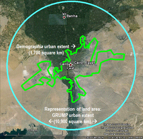
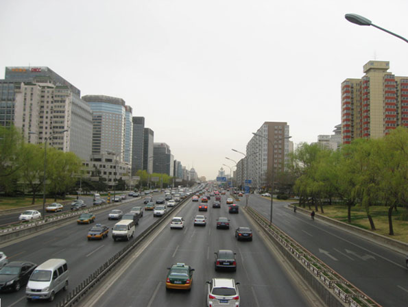
    We can use Paris as a typical example.  The city of Paris reached its peak population of nearly 3 million in the 1920s.  It has lost nearly a third of its population since then.  What remains in the city is a smaller and wealthier population.  At the same time the suburbs, accommodating both families of modest income forced out of the city as well as a burgeoning middle class,  have grown enormously, from two million to over eight million.  And this does not count a great deal of essentially urban population that that lives in a vast ring of exurban or “peri-urban” settlement.  Certainly the majority of “urban” dwellers in the Paris region do not live in the elegant apartment blocks along the great boulevards familiar to the tourist.   They live in houses or small apartment buildings in the suburbs and use the automobile for their daily transportation needs.

    In fact, Paris is a good example of an even more fundamental irony.  At the very moment when urban population has been reported to surpass the rural, this distinction has lost most of its significance, at least in many parts of the affluent world.  Two hundred years ago, before automobiles, telephones, the internet and express package services,  cities were much more compact and rural life was indeed very different from urban life.  Most inhabitants of rural areas were tied to agriculture or industries devoted to the extraction of natural resources. Their lives were fundamentally different from those of urban dwellers. 

    Today the situation has changed radically.  Most people living in areas classified as rural don’t farm or have any direct connection with agriculture.  They hold jobs similar to those in urban areas.  And although they might not have opera houses, upscale boutiques or specialized hospitals nearby, the activities that take place in these venues are available to them in ways that they never were before.

    I can confirm the way the distinction between urban and rural has broken down by looking out the window of the house in Omro, WI where I am staying this weekend.  Omro, population about 3000, is located 8 miles west of Oshkosh and is  legally a city under Wisconsin law.  It is also an “urban” place according to the Census Bureau which, like those of other countries, defines urban largely by density standards.   In the case of the US, this means, in simplest terms, a density of at least 1000 people per square mile or just under two people per acre. 

    At one time this 1000-people-per-square-mile figure did provide a logical demarcation line.  Above those densities were places that could afford urban services like public water and sewers, sidewalks, streetlights, municipal fire departments and libraries.  Below that level were places that either didn’t have these services or had to depend on faraway county governments.  Unless you were closely associated with agricultural production or other rural economic activities or you were wealthy enough to provide your own services, it was quite inconvenient to live in rural areas. 

    Today, the automobile, rural electrification, the internet and the rise of alternate and privatized services has transformed what it means to live in rural areas.  “Country living” today has few of the drawbacks that made it inconvenient for middle class residents as recently as fifty years ago, and the migration of so many urbanites into the country has blurred the distinction between urban and rural.

    The view out my window bears this out.  When I look one direction what I see are city streets and houses on land that is technically urban.  Of course, Omro, with a single main street, two traffic lights and only a handful of stores, is not at all the kind of place that most people associate with the words “city” or “urban.”  Like the majority of small urban places in this country, its densities are lower than those found in the suburbs of larger cities.   When I look out the other direction I see mostly fields beyond the city limit.  But, unlike the case in the past,  there is no sharp divide.  There has been a significant increase in the number of houses out in the area that is technically “rural.”  Some of these used to be farmhouses, but there are few farmers anywhere for miles around.  Most farming is now done under contract or  as a large industrial-scale operation.   

    Most of the houses in the “rural” area around Omro have been built in the last decade or two and never housed anyone with any direct connection to farming.  They are suburban in appearance and mostly inhabited by people who work at home, are retired or commute some distance to jobs spread across a vast swath of urban territory that stretches from Fond du Lac south of Lake Winnebago to Green Bay where the Fox River meets Lake Michigan. 

    The result is that today, as you drive outward from the center of Fond du Lac, Oshkosh, Appleton or Green Bay, the number of houses per square mile diminishes, but there is no clear break between city and country.  It is a crazy quilt of agricultural, residential and other uses.  Commuting patterns, if charted on a map, would form a giant matrix of lines running in all directions.  Whether one is in the center of Oshkosh or 50 miles away, however, one can still live an essentially urban existence.   

    This same diffused urban condition holds true for very large swaths of the United States wherever there is enough underground water to allow wells. It is particularly conspicuous in the older and more densely settled eastern part of the country.  A state like New Jersey exhibits a pattern of dense older cities, radiating suburbs, vast exurban territories and farmland and open space, overlapping in ways that confound traditional notions about what is urban and rural. In places like New Jersey, the census distinction has lost almost all of its meaning.

    I don’t mean to suggest that that the news that the majority of the world’s population is now urban has no significance.  In fact this move from the countryside to urban areas has been one of the defining events of world history over the last several centuries.  Although this process was mostly finished in Western Europe and the United States decades ago, it still continues in most of Latin America, Africa and Asia and accounts for a great deal of the dramatic upward surge in income throughout the world.

    Nor am I suggesting the demise of the great cities of Europe or America.  Far from it.  Many rich families in particular will probably continue to choose high-density neighborhoods like those on the Upper East Side of New York or the 16th arrondissement in Paris, although often with a rural retreat as well  As the world gets wealthier, more people may make a choice to live in this way.

    However, current trends give no reason to believe that places like Manhattan or central Paris are going to increase in population and density as part of a “back-to-the-city” movement.    As cities gentrify, they undoubtedly become more attractive, but increased demand leads to higher prices keeping out many families who might choose to live in them.  Furthermore, the gentrifiers tend to have smaller families than those they replace, and they also tend to demand  more room, larger and better equipped housing units, more parks and open spaces.  Because of this, the gentrifiers, citing the need to preserve existing neighborhoods, frequently put up all kinds of barriers to new development and increased population and density, particularly by less affluent citizens.  For all these reasons,  existing city centers in the affluent world are unlikely to accommodate a significantly larger percentage of the population.

    Even in the developing countries, as urbanist Shlomo Angel has shown, most cities are spreading outward at ever lower overall densities just as cities have been doing for many years in the affluent West. For those who don’t have a lot of affluence, and even some who do, low density suburban- and increasingly, even lower density exurban- living, remains alluring for many in both the affluent and the developing world.   In fact, we might even be seeing the initial stages of a major reversal of the kind of urbanization that characterized industrializing cities in the West in the 19th and early 20th centuries. The sharp increase in houses outside Omro may presage at least a partial return to a pre-industrial condition seen, for example, in nineteenth century America when people were more evenly spread across the landscape. 

    This continuing urban sprawl is, of course, deplored by many of those who celebrate the supposed triumph of the “urban age. “ Yet  as I have argued in my book Sprawl:  A Compact History, this phenomenon is by no means as bad as most anti-sprawl crusaders imagine it to be.  Continuing to spread the population could conceivably result in a more equitable, more sustainable pattern of living, particularly as renewable energy and other resources are harvested close to home with less need of the giant systems necessary to maintain our dense industrial-age cities.  In any case, despite all of the planning regulations put in place in cities throughout the affluent world to control growth at the edge, the periphery continues, inexorably, to expand almost everywhere. 

    Nowhere does the evidence suggest that we are witnessing the final triumph of the traditional high-density city.  In fact, the much-ballyhooed urban majority might be in great part a statistical artifact, a way of counting the population that over-emphasizes the move from country to city and fails to account for the powerful counter-movement from the city back toward the countryside.  Indeed the emerging reality of overlapping patterns of high density centers, lower-density peripheries and vast areas of very low density urban settlement, all of them interspersed with agricultural lands and protected open spaces, threatens to upend altogether the traditional notion of what it means to be urban.   

    Robert Bruegmann is professor emeritus of Art history, Architecture and Urban Planning at the University of Illinois at Chicago.
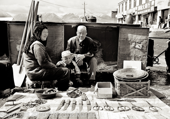
    Photo by urbanfeel.

  • A Fly in the Econometrics? Exaggerating Urbanization

    I was surprised to read in Science Digest that the increase in the urban land from 2000 to 2030 could be as much as 590,000 square miles (1.53 million square kilometers), which Science Digest went on to say would house an increase in the urban population of 1.47 billion people. The shock was because the researchers are suggesting that the substantial urbanization that will occur over the first three decades of this century will be at American urban densities, 2500 per square kilometer or 1000 per square mile. 

    Urbanizing on 1 to 3 Acre Lots? But that was just the beginning. The econometric research, A Meta-Analysis of Global Urban Land Expansion by Karen C. Seto, Michail Fragkias, Burak Güneralp, and Michael K. Reilly, partially funded by the National Science Foundation, indicates that the increase in urban land area between 2000 and 2030 could be as much as 4,900,000 square miles, or 12,600,000 square kilometers. This is more than the area of Australia, Argentina and Mexico combined. It does, however, seem unlikely that developers and home builders will provide for the expanding urbanization in China, India, Indonesia, the Congo, South Sudan and Bangladesh with ranch houses on one to three acre lots.

    The 4.9 million square mile or 12.6 million square kilometer urban land increase figure is based upon the GRUMP database, which we reviewed a year ago. GRUMP found the world to have more than 1.3 million square miles of urban development or 3.5 million square kilometers. The GRUMP database is purported to use United States Census Bureau criteria for designating urban land, yet counts three times as much land in the United States as being developed as the Census Bureau. We also showed that the GRUMP urban area for Cairo was at least six times the actual urbanization based upon examination of Google Earth maps (Figure 1: map).

    ng-grump2


    At 4.9 million square miles or 12.6 million square kilometers the average new urbanization would be under 500 per square mile or 200 per square kilometer. These densities fall well short of the urban density thresholds of 1000 per square mile or 400 per square kilometer that are used by census authorities in Canada, France, the United Kingdom and the United States. These nations and others consider densities this low to be rural rather than urban. Indeed, parts of rural China have higher densities than the GRUMP density estimates.

    Estimating Gross World Urban Area: Other estimates of world urbanization are more modest than the GRUMP estimate, which indicated an urban land area of 3,532,000 in 2000. The US Geological Survey MODIS mapping system estimated world urban land area at 650,000 square kilometers in 2000. In A Planet of Cities, Shlomo Angel, Jason Parent, Daniel Civco, Alexander Blei, and David Potere (Angel) use USGS MODIS mapping and further modeling to estimate the 2000 world urban land area at 605,000 square kilometers. Another source, the European Union’s Global Land Cover system put the number at 308,000. The wide variation in estimates indicates the complexity of the task of estimating the world’s urban land area.

    The estimates can be evaluated by comparing their implied population densities.

    • The EU Global Land Cover estimate would have required an average urban population density of more than 9,000 per square kilometer (23,800 per square mile) in 2000, based upon the 2000 United Nations estimate of urban population. This is nearly as dense as the city of New York (not the urban area) and a quarter more dense than Singapore. Anyone who has traveled to urban areas around the world, large and small, would quickly observe that average densities approach neither New York City nor Singapore. The Global Land Cover estimate thus appears to be too low.
    • The GRUMP world land area estimate would mean that the average urban population was 800 per square kilometer in 2000 (2,000 per square mile). This would place the world urban population density at least 15 percent below that of the United States  (900 per square kilometer or 2,400 per square mile) or Canada in 2001 (1,000 per square kilometer or 2,500 per square mile). As every urban planner knows, the United States has the least dense urban areas of any major nation. GRUMP thus appears to substantially over-estimate the amount of urban land.
    • The MODIS and Angel estimates are similar. The MODIS estimate would require an average world urban density of 4,300 per square kilometer (11,100 per square mile), while the Angel estimate would indicate a world urban density of 4,700 per square kilometer (12,200 per square mile). These two estimates would appear the most accurate, because they are well above the US and Canadian densities and any visitor to Manila, Shanghai, Cairo or a myriad of other urban areas in the developing world cannot help but note the much higher densities. At the same time the MODIS and Angel are well below the EU Global Land Cover estimates, which appear to be very high (Figure 2). The MODIS and Angel estimates would indicate that approximately 0.5 percent of the world’s land area is urbanized.

    Demographia World Urban Areas also provides population, land area and urban density estimates, though its detailed data is limited to approximately the approximately 800 urban areas with more than 500,000 population. Applying the Angel, et al urban area size density ratios and projections for urban expansion to 2010 (Angel middle scenario), the Demographia world density estimate would be approximately 20 percent lower, while the urban land area would be 25 percent higher). Demographia World Urban Areas bases its estimates on national census bureau data for urban areas (Note) where it is available and for others estimates urban land area from Google Earth (these are the overwhelming majority of cases), using urban perimeters. More than 50 percent of the difference between the Demographia and Angel estimates results from the use of Census Bureau urbanization data in the United States.

    Believable and Unbelievable Projections: Angel also provides projections for the increase in urban land area. Between 2000 and 2030 Angel projects that new urbanization could be from a middle case of 700,000 square kilometers (270,000 square miles) to a high estimate of 1,160,000 square kilometers (445,000 square miles), with a low case of 360,000 square kilometers (140,000 square kilometers). These are believable figures that are only a small fraction of the high-end 12,600,000 square kilometer (4,900,000 million square miles) projections by Seto, et al.

    The circumstances that might lead to urbanization equaling the land area of Australia, Argentina and Mexico are not believable. A sufficient reasonableness test does not appear to have been conducted.

    Wendell Cox is a Visiting Professor, Conservatoire National des Arts et Metiers, Paris and the author of “War on the Dream: How Anti-Sprawl Policy Threatens the Quality of Life

    ——

    Note: Most of the world’s national census authorities provide geographical data for only legal jurisdictions, such as states, provinces, regions, counties, etc. In some nations, urban area is developed to indicate the population and land area of continuous urbanization. This occurs in the United States, Canada, the United Kingdom, France, Sweden, Denmark and other nations.

    Photo: Developing world urbanization trend to 2030 according to high-end proectiong based upon GRUMP. Houses on two acre lots in Morris County, New Jersey (suburban New York). From Google Earth Pro.

  • Millennials Have the Answer to the Country’s Fear, Uncertainty and Doubt

    America is about to enter a presidential campaign that promises to be filled with divisive rhetoric and sharp differences over which direction the nominees want to take the country. This will be the fourth time in American history that the country has been sharply divided over the question of what the size and scope of government should be. Each time the issue was propelled by vast differences in beliefs between generations that caused the country to experience long periods of Fear, Uncertainty and Doubt (FUD), before ultimately resolving the issue in accord with the ideas and beliefs of a new generation.

    Every eighty years America engages in this rancorous, sometimes violent, debate about our civic ethos. The first occurred during and after the Revolutionary War and resulted in the most fundamental documents of our democracy: the Declaration of Independence, the Constitution, and the Bill of Rights.

    The second took place during the Civil War. The 13th, 14th, and 15th Amendments codified the outcome of that debate — this time in favor of the federal government asserting its power over state laws when it came to fundamental questions of personal liberty and civil rights.  It took the Civil War and a massive increase in Washington’s power to accomplish the end of slavery, although it would be another century until the rights of freedom and equality were fully extended to African-Americans. 

    And in the 1930s, the economic deprivations experienced by most Americans from the excesses of the Industrial Revolution, and the collapse of corporate capitalism, led to support for a “New Deal” for the forgotten man that placed the responsibility for economic growth and opportunity squarely on the federal government. The government demanded by the GI Generation (born 1901-1924) greatly surpassed the conventional views of earlier generations.

    In each case, the resolution of these debates depended on the emergence of a rising, young civic-oriented generation that thought the nation’s dominant political belief system   should contain a strong role for government, overturning the more conservative and limited-government views of the older generations then in power.

    Now, as previously, the highly charged ideological arguments on both sides of the issue generate great agitation and anger among older generations, especially Baby Boomers, who have driven our political life towards ever wider polarization. As a result, the resolution of today’s debate over the nation’s civic ethos is not likely to come from older Americans who seem incapable of and unwilling to compromise their deeply held values and beliefs.

    This time around, the largest generation in American history, Millennials, (born 1982- 2003), that  will comprise more than one in three adult Americans by the end of this decade, are destined to play a decisive role in finding a consensus answer to this critical question.   If the United States is to emerge from this most recent period of FUD, it will have to look to the newest civic-oriented generation, Millennials, for both the behavior and the ideas that will bridge the current ideological divide and spur the country into making the changes necessary to succeed in the future.

    Millennials believe that collective action, most often at the local level, is the best way to solve national problems. Using social media, Millennials are organizing groups like the Roosevelt Institute’s Campus Network, to present a very different vision of America’s future. In this Millennialist future, the idea of top down solutions developed by experts in closed discussions will give way to bottom up, action-oriented movements. This will topple institutions as dramatically as Napster upended the recording industry, or the Arab Spring changed the Middle East.  Just as their parents set the rules within which Millennials were free to exercise their creative energies when they were growing up, the new generation will continue to look to the federal government to set national goals or guidelines, as has long been the view of Boomer progressives.   However, the way in which these guidelines are implemented will not be determined in remote and opaque bureaucracies, but by individuals in local communities across the country. In this way, Millennials will embrace progressive values, but with approaches that may be welcomed by many conservatives.

    In the midst of the country’s current period of FUD, it is easy to despair that the nation will be unable to resolve its divisions and come to consensus about a new civic ethos. But throughout its history, when America has been equally fearful of the future, a new civic generation has risen to foster the necessary transition. In the end, this emerging generation served both itself and the country well. Now it is the Millennial Generation’s turn to serve the nation and move America to a less fearful and less divided future.  

    Morley Winograd and Michael D. Hais are fellows of NDN and the New Policy Institute and co-authors of the newly published Millennial Momentum: How a New Generation Is Remaking America and Millennial Makeover: MySpace, YouTube, and the Future of American Politics.

    Photo by kevindooley.

  • Supply of Tech Workers Greater Than Estimated Demand

    CNBC reports the information technology (IT) sector is “where the jobs are.” And the Los Angeles Times writes that tech jobs in San Francisco are a “rare bright spot in the nation’s troubled economy.”

    EMSI’s most current data, however, paints a slightly less rosy picture.

    It’s clear that IT and tech jobs have mostly bounced back since the recession (or barely saw employment dips in the first place). But not every tech-related profession is faring well; jobs in computer programming, for example, have failed to reach pre-2008 levels.

    And in almost all cases, the supply of IT and tech grads far outweighs the estimated annual openings in those areas over the next five years.

    Overall Trends

    IT jobs are spread across nearly every sector, making labor market analysis at the industry level a bit tricky. Tech jobs too are varied and can incorporate many different activities. For this data spotlight, we focused on 11 occupations — mainly in the computer specialist and database/network administrator realm.

    SOC Code Description
    2006 Jobs
    2011 Jobs
    Change
    % Change
    15-1011 Computer and information scientists, research
    28,349
    30,648
    2,299
    8%
    15-1021 Computer programmers
    452,953
    433,188
    (19,765)
    (4%)
    15-1031 Computer software engineers, applications
    511,199
    555,917
    44,718
    9%
    15-1032 Computer software engineers, systems software
    404,764
    430,792
    26,028
    6%
    15-1041 Computer support specialists
    572,327
    567,082
    (5,245)
    (1%)
    15-1051 Computer systems analysts
    584,711
    606,473
    21,762
    4%
    15-1061 Database administrators
    111,008
    113,975
    2,967
    3%
    15-1071 Network and computer systems administrators
    347,629
    358,743
    11,114
    3%
    15-1081 Network systems and data communications analysts
    355,264
    407,983
    52,719
    15%
    15-1099 Computer specialists, all other
    212,981
    221,861
    8,880
    4%
    17-2061 Computer hardware engineers
    70,797
    68,040
    (2,757)
    (4%)
    SOURCE: EMSI Complete Employment (2011.3)

    In total, these 11 tech-related jobs have grown by 3.9% since 2006 in the US (nearly 143,000 new jobs). The only professions on this list to see a net loss in jobs over the last five years are computer support specialists, computer hardware engineers, and computer programmers.

    Computer support specialists account for the second-most jobs of any occupation in this tech group, and they’ve started to make their way back up with growth from 2010-2011. But hardware engineers and programmers continued to shed jobs in the last year — after seeing drops of 5.6% and 5%, respectively, from ’08 to ’09.

    Key Industries for Tech Jobs

    With EMSI’s research tool, Analyst, we’re able to quickly shift from examining occupations to the top industries that staff those occupations (via inverse staffing patterns). This is a particularly useful analysis for tech jobs.

    Consider the case of programmers: the industry breakdown shows this profession is becoming more specialized. In the last five years, there are more programmers in the computer systems design services and custom computer programming services industries, but fewer in generalized industries such as temporary help services, corporate offices, and state and local government.

    FASTEST-CHANGING INDUSTRIES FOR COMPUTER PROGRAMMERS
    NAICS Code
    Description
    2006-11 Change
    541512 Computer Systems Design Services
    6,865
    541511 Custom Computer Programming Services
    5,225
    561320 Temporary Help Services
    -2,400
    541519 Other Computer Related Services
    -2,335
    518210 Data Processing, Hosting, and Related Services
    -1,076
    920000 State government
    -1,020
    930000 Local government
    -726
    541513 Computer Facilities Management Services
    -721
    551114 Corporate, Subsidiary, and Regional Managing Offices
    -590
    511210 Software Publishers
    -376

    This data also suggests that some tech industries — like data processing/hosting services and other computer related services — are either getting by with fewer programmers and other assorted tech workers, or a good number of these positions have been offshored.

    That doesn’t seem to be the case as much with software engineers. More of these workers have been added to IT-related industries and general industries since 2006. The biggest exceptions are wired telecommunication carriers and data processing, hosting, and related services.

    FASTEST-CHANGING INDUSTRIES FOR SOFTWARE ENGINEERS (15-1031 and 15-1032)
    NAICS Code
    Description
    2006-2011 Change
    541512 Computer Systems Design Services
    35,339
    541511 Custom Computer Programming Services
    24,660
    511210 Software Publishers
    5,727
    551114 Corporate, Subsidiary, and Regional Managing Offices
    3,260
    541712 Research and Development in the Physical, Engineering, and Life Sciences (except Biotechnology)
    2,971
    517110 Wired Telecommunications Carriers
    -2,310
    541330 Engineering Services
    1,310
    518210 Data Processing, Hosting, and Related Services
    -1,080
    334111 Electronic Computer Manufacturing
    -1,048

    Metros with Highest Concentration of Tech Workers

    The area with the largest share of tech workers, on a per capita basis, probably won’t come as a huge shock. The San Jose metro, home to Silicon Valley, is more than 4 times more concentrated in tech workers than the nation, and it has the highest median earnings. With a median wage of $50.14 per hour, San Jose has 7% higher wages than the second best-paying metro, Bridgeport, Conn., ($46.59), and 17% higher wages than the third metro on the list, Boston-Cambridge ($41.69).

    Boulder, Colo., is the second-most concentrated metro, at more than 3 times the national average, followed by DC (with a location quotient of 2.73) and Durham-Chapel Hill, NC (2.7).

    Meanwhile, DC and Seattle-Tacoma have seen the most new tech jobs since 2006. DC has added 18,205 jobs (9%), Seattle has added 14,762 (16%), while San Jose is third with 11,102 new jobs (12%).

    Supply/Demand Imbalance

    The job market for tech workers in San Jose, San Francisco, and other pockets of the country seems to be thriving. But there also appears to be a considerable excess of new graduates in these fields compared to the annual demand over the next five years. According to EMSI estimates, there are more than 3 times as many graduates as annual job openings through 2016.

    We gauged the supply of 2009 grads from programs associated with the 11 tech professions using the US Department of Education’s IPEDS database, and looked at the completions in comparison to estimated annual openings (new and replacement jobs) for the same jobs. Note: Not all graduates from tech-related programs will work in tech-related fields (though in higher-skilled areas such as these, the chances are higher) and IPEDS data is subject to misreporting/error on a college-by-college basis.

    Looking at the supply/demand numbers for the individual tech occupations, computer and information scientists have the largest glut (56,865 too many grads per year). Two other occupations have graduate oversupplies that exceed 50,000: network and computer systems administrators and computer specialists, all other.

    There’s only one occupation, meanwhile, with a shortage of associated graduates: computer support specialists (not to be confused with computer support specialists, all other).

    SOC Code
    Description
    Annual Openings
    2009 Completions
    Surplus/Shortage
    2011 Median Hourly Earnings
    15-1011 Computer and information scientists, research
    1,239
    58,104
    56,865
    $44.90
    15-1071 Network and computer systems administrators
    13,234
    66,273
    53,039
    $31.75
    15-1099 Computer specialists, all other
    7,342
    59,726
    52,384
    $35.04
    15-1061 Database administrators
    3,866
    46,498
    42,632
    $33.48
    15-1081 Network systems and data communications analysts
    21,081
    56,792
    35,711
    $28.07
    15-1032 Computer software engineers, systems software
    13,664
    42,621
    28,957
    $42.80
    15-1021 Computer programmers
    9,670
    29,847
    20,177
    $31.38
    15-1031 Computer software engineers, applications
    18,951
    34,105
    15,154
    $40.15
    15-1051 Computer systems analysts
    23,023
    38,104
    15,081
    $34.23
    17-2061 Computer hardware engineers
    2,420
    5,804
    3,384
    $46.17
    15-1041 Computer support specialists
    22,449
    3,424
    -19,025
    $21.10
    Total
    136,939
    441,298
    304,359

    Joshua Wright is an editor at EMSI, an Idaho-based economics firm that provides data and analysis to workforce boards, economic development agencies, higher education institutions, and the private sector. He manages the EMSI blog and is a freelance journalist. Contact him here.

    Illustration by Mark Beauchamp

  • The Evolving Urban Form: Beijing

    China’s capital, Beijing, has long been one of the world’s largest urban areas. Some reports placed its population at over 1 million in 1800, which would have made Beijing the largest urban area  in the world at that time. Later in the nineteenth century, Beijing dropped below 1 million population, as London, Paris and later New York rose to prominence. As late as 1953, Beijing had a population of fewer than 3 million. Since then the city’s population has  increased more than six times (Figure 1).

    Beijing is one of China’s four "directly administered municipalities" or "provincial level municipalities," along with Shanghai, Chongqing and Tianjin (Note 1). Moreover, like Shanghai and Tianjin, Beijing is essentially a metropolitan area, composed of an urban area and exurbs approximating a labor market. This is unlike Chongqing, which has extensive rural areas and extends far beyond any plausible definition of a metropolitan area (having the land area approximately the size of Indiana or Austria).

    The Growing Beijing Urban Area: In the 1990s, Beijing added 2,700,000 people and had a population of 13.6 million in 2000. Between 2000 and 2010, Beijing population increased by more than double the previous increase, or an increase of 6 million people.

    The Expanding Beijing Urban Area: Based upon the most recent census, the next edition of Demographia World Urban Areas will estimate an urban area (urban footprint) population of 17 million, with an urban land area of 1,350 square miles (3,500 square kilometers) and an urban density of 12,600 per square mile (4,900 per square kilometer) in 2011. Beijing ranks as the world’s 12th largest urban area and is larger than any urban area in the United States or Europe with the exception of New York. As in other urban areas of China, there is considerable undeveloped land in enclaves within the suburban areas, which could develop further, raising both the population and the density.

    Falling Urban Densities: Even so, Beijing is far less dense than before. Deng and Huang at the State University of New York, Albany, place the 1949 urban land area at less than 25 square miles (63 square kilometers. Based upon its early 1950s population of less than 3,000,000, the population density of the entire urban area could have been more than 100,000 per square mile or 40,000 per square kilometer (precise urban population is not available). This is greater than the highest density major urban area today, Dhaka (Bangladesh) at 90,000 per square mile or 35,000 per square kilometer. Today’s urban Beijing may have an overall population density one-eighth that of the 1950s.

    This illustrates a reality often missed by urban analysts, who confuse population growth with increases in population density. In fact, as the Evolving Urban Form series (Note 2) indicates, dispersion is at least as important in the expansion of megacities as population growth itself. Population densities generally decline as urban areas add residents.

    Suburbanizing Beijing: Consistent with the international urban trends, most growth over took place outside the core (see table at bottom and Figure 2). As Beijing has suburbanized, it has added "ring roads," (beltways or loops) which except for the 1st ring road (around the Forbidden City) are freeways, often with Texas-style frontage roads (See "2nd Ring Road" photo). Now there are six ring roads and there has been some discussion of a seventh, which would extend to the adjacent Hebei province to the south. Real-time traffic conditions on the first five ring roads can be seen at the Beijing Traffic Management Bureau site (the 6th ring road is outside the map)


    2nd Ring Road with frontage roads

    At the same time, Beijing’s expansive suburbs do not resemble the low-density suburbanization of Phoenix, Portland, Perth or Paris. Much of the development is in high rise condominiums and a substantial part is lower quality, lower rise development that houses Beijing’s large and growing migrant population (referred to as the "floating population"), most of whom do not have Beijing resident (hukou) status. Even so, there is no shortage of detached luxury housing (called "villas") in western style developments. such as "Orange County." More recently there is increasing demand for a more modern version of the "siheyuan" (courtyard) housing makes up the renown "hutong" areas of Beijing and other Chinese cities. One website refers to the "siheyuan" as the Chinese version of the "American Dream" and a recent China Daily commentary even suggested that this type of housing should constitute the future expansion of Beijing.  However, a quick review of real estate offerings for the new siheyuans, makes it clear that they are simply unaffordable for a growing middle class that finds it difficult to afford new flats in high rises outside the 4th ring road.  

    Hutong neighborhood (Dongcheng qu)

    A map of Beijing’s districts can be seen here, with color coding that corresponds to the geographical divisions in the table.

    The Inner City: During the last census period, less than one percent of the population growth has been in the inner city, which consists of the districts of Xicheng and Dongcheng, largely inside the 2nd ring road and contains the Forbidden City, Tiananmen Square, the Drum Tower (see photo below) and Bell Tower, and the Yonghegong Lama Temple (Buddhist). These districts, which contain nearly all of the remaining hutong (see photo above) residences grew only 2.2 percent. At 61,000 people per square mile (23,500 people per square kilometer), inner Beijing approaches the population density of Manhattan or the Ville de Paris.


    Toward the Drum Tower, from Jingshan Park

    Outside the Inner City: More than 99 percent of Beijing’s growth was outside the inner city. The first and second ring suburbs accounted for 96 percent of the growth, while the outer areas accounted for three percent of the growth.

    First Ring Suburbs: The four inner suburban districts of Beijing captured 52 percent of the provincial growth between 2000 and 2000. Overall, the four suburban districts added 3.2 million people, a nearly 50 percent increase in population. The population density in the inner suburbs was 19,400 per square mile in 2010 (7,500 per square kilometer). This is a higher density than the city of San Francisco. The inner suburban districts are generally located within the 5th ring road. The first ring suburbs include the district of Chaoyang, which has the largest population and where at least one-half of the population    generally lack Beijing residency (hukou). Chaoyang is also home to the new Beijing "central business district," (CBD) which is the largest concentration of high rise towers in the urban area includes  the controversial architectural icon, the CCTV Headquarters (photo at the top). The development of the CBD in the inner ring suburbs and other major commercial development are indicative of a dispersion of employment that, if permitted to continue, could ease Beijing’s legendary traffic congestion.

    Second Ring Suburbs: The outer suburban districts accounted for 44 percent of the provincial population increase between 2000 and 2000 and 2010. However, the outer suburban districts had the highest growth rate, at 72 percent, The outer suburban districts are generally located outside the 5th ring road and include considerable rural territory. The population density is 2100 per square mile (800 per square kilometer). Beijing Capital International Airport is located in this area, though it is under the jurisdiction of the inner ring district of Chaoyang. This airport is now the world’s second busiest in passenger volume, following Atlanta and having passed perennial runner-up O’Hare International in Chicago. At current growth rates Beijing Capital International could become the world’s busiest airport within five years.

    Outer Areas: The outer areas are largely rural and well outside the urban area. Nonetheless, the growth rate in the outer areas was well above the national rate and six times the rate of the inner city. The outer areas gained 186,000 people, approximately four times the inner city gain.

    Future Challenges: The floating population Beijing (and Shanghai) represented most of the population growth from 2000 to 2010. More than 7 million of Beijing’s nearly 20,000,000 population are migrant workers.   Government officials have expressed concern at the rate of population growth and have indicated an interest in severely limiting future population growth. Among Beijing’s considerable challenges is providing sufficient water for its large population. Beijing lacks the plentiful supply of water that is available to many urban areas of central and southern China (example, Shanghai, Nanjing, Wuhan and Chongqing) and the government is building a system to divert water especially from the Yangtze River. The 2020 census results could reveal a significant slowdown in growth, if these problems are not sufficiently addressed. 


    Beihei Park

    Wendell Cox is a Visiting Professor, Conservatoire National des Arts et Metiers, Paris and the author of “War on the Dream: How Anti-Sprawl Policy Threatens the Quality of Life

    ——–

    Note 1: What are translated as "cities" in China are not cities as understood in the West. A "shi" in China (translated as "city") is actually a region that may approximate a metropolitan area or labor market area in the West (with an urban core and a much larger surrounding rural territory). Some "shis" are much larger, however, such as Chongqing, which covers a land area similar to that that of Austria and nearly as large as Indiana. Chongqing and many other "cities" are far larger than any plausible metropolitan area definition.

    "Shi" may exist either at the provincial level (as in the case of Beijing, Chongqing, Shanghai and Tianjin) or it may exist within a provincial level jurisdiction, such as Nanjing in Jiangsu. Guangzhou in Guangdong or Wuhan in Hubei. Every square mile of a province (excepting the provincial level jurisdictions) is divided into shis, prefectures or comparable units, in the same way that US states are divided into county level jurisdictions or the regions of France are divided into departments. To complicate matters more, shis themselves may have county (xian) level shis within their borders, such as Cixi, a county level shi with approximately 1,000,000 people within the Ningbo shi in Zhejiang province.

    Note 2: Other megacities reviewed in this series have been: Jakarta, Los Angeles, Manila, Mexico City, Mumbai, New York ,Seoul and Shanghai .

    Photo: CCTV Headquarters in new Beijing CBD, Chaoyang district. Photo by Iamdavidtheking.

    All other photos by author.

  • Austin’s Not That Weird

    Don’t let the cupcake stands fool you. For years, locals pressed the need to Keep Austin Weird. Besides spawning lazy clichés (Keep Austin Wired, Keep Austin Moving, Keep Austin on Every List of Best Places to Live), the Keep Austin Weird movement overlooks the obvious: the city’s not that weird.

    Weird for Texas? Sure. Austin is like a rebellious preacher’s kid. It’s cool, popular, breaks all the rules, and doesn’t go to church very much. Family members from elsewhere visit from time to time, but everyone wonders if they’re all part of the same family.

    It’s been this way forever. When most of the state decided to join the Confederacy, Austin declined. When most of the state decided to join the Republican Party, Austin declined.

    The capital is more counter-Texas than counter-culture. Austin boasts unique attractions, festivals, and music venues. It’s livable, a hard term to quantify until Austinites visit other cities and return recounting their flaws. Austin also has an infectious, welcoming spirit. You can strike up random conversations with random people at the grocery check-out. Still, it’s not as strange as advertised. Let’s dispel the most common myths:

    MYTH #1: It’s San Francisco. It’s not. The City by the Bay is smaller, denser, and more ethnically diverse. Both cities have roughly equal populations, but Austin packs them into approximately 300 sq. miles; Austin is six and half times larger than San Francisco. Neither city has a white majority, but nearly one in two Austinites is white, compared to just four in ten San Franciscans. So Austin’s full of Stuff White People Like: trailer food, snow cone stands, vintage clothiers, writer’s groups, Paleolithic restaurants, coffee shops, and yoga studios. It’s not the gayest city in Texas, either. Dallas narrowly edges out Austin, according to analysis by the Williams Institute at the UCLA School of Law.

    MYTH #2: It’s a small town. As the 14th largest American city, Austin has big city problems.

    Traffic tops the list. Forget rush hour. It’s not unusual to find your car parked on I-35, the city’s clogged artery, on a Sunday afternoon. The ill-equipped interstate reflects city planners’ inverse Field of Dreams strategy: if you don’t build it, they won’t come. Back when Austin really was a small town, some thought expanding I-35 would encourage newcomers. They came anyway.

    A growing metropolis suffers growing pains, and Austin hasn’t outgrown racial or economic segregation. Housing costs, among the state’s highest, contribute to geographic divisions. The city’s affluent congregate in the west side, while middle-earners who want homes settle near, or in, once-empty Williamson and Hays counties. Austin’s east-siders are mostly low-income minorities, but as The Atlantic’s Ta-Nehisi Coates observes, gentrification is changing this.

    In search of cheap in-town property, a mix of white urban professionals and bohemians started sprucing up homes just east of I-35 over a decade ago. High-end lofts now co-exist, a bit awkwardly, next to mercados. The east side has become less a barrio, with new stores, houses, and other developments dotting neighborhoods. Still, it’s no yuppie playground.

    MYTH #3: It’s Babylon. Fear not, God-fearing Americans! Austinites aren’t as eccentric or wayward as you may have heard. For years, natives have touted wandering gender-bender Leslie Cochran as their mascot. To locals, Leslie embodies Austin’s free-spirit; to outsiders he’s evidence Austin is Gomorrah near the Guadalupe. Leslie nearly died in 2009, however, and Jennifer Gale, a homeless transgendered activist, died in the cold in 2008. Austin still has its fair share of eccentrics—the unicycle, mind you, is a perfectly acceptable mode of urban transport—but you won’t find fire-eaters on every corner.  

    This city of alleged non-conformists dresses the same (and never up). Shorts and flip-flops, the uniform of least resistance, will get you in nearly any club or restaurant. The University of Texas, state government, and tech companies compose Austin’s economy. Professors, bureaucrats, and software engineers—let the Bacchanal begin! During South by Southwest, locals can easily pinpoint the Bay Area-Portland-Williamsburg interlopers. As they party, promote, and pose, the skinny jean set manically turns their attention from iPhones to panel discussions to guest-list gatherings. Austinites run at a more relaxed pace. Unlike these coastal scenesters, they would rather chill out than stand out.

    MYTH #4: It’s not like other cities. In many ways, Austin is exceptional. The urban core features gems like Zilker Park, a marvelous pink granite Capitol, and home-grown eateries. Leave the central core, however, and you quickly encounter big-box sameness.

    As you head south of Ben White Boulevard or north of the University of Texas, national retailers, food chains, and strip malls appear. Once a destination concert venue, Southpark Meadows is now a destination for south Austin Target shoppers. Up north, The Domain, an upscale shopping village, gives off a gentle North Dallas pretention, which is the opposite of Austin weird.

    Even Whole Foods, the Temple of Austin, causes headaches. The retailer is Disneyland for foodies, if you can get there or find parking. Sky-rise condos flank the flagship store, and getting past nearby intersections and into a parking space can feel like a bumper car ride. This congested urban development angers locals who fear their homeland now caters to well-off creative professionals instead of cash-strapped musicians and artists.

    No wonder some residents feel compelled to remind everyone to Keep Austin Weird. Put it on a tee-shirt. Put it on a bumper sticker. Shout it from your co-op’s rooftop: I have seen the Promised Land, and it is (or was) weird.

    How odd that a progressive city would revert to this reactionary battle cry. Those who love the phrase look back and see an odder, better place or ahead and see disturbing signs of normalcy. Both sales pitch and civic anthem, the Keep Austin Weird campaign aspires to change development through mantra. Like a New Age chant, it hopes to alter consciousness. If you say it enough, maybe it will come true.  

     Does Austin have to be weird to be special? It has plenty of attractive, well-educated citizens, natural beauty, and warm weather (record-setting levels this year, in fact). It’s still far cheaper than most coastal meccas. When magazines rank it as a great place to move or start a business, weirdness isn’t their criterion. Despite the big city headaches, the quality of life is still pretty sweet. Can’t we just follow The Beatles’ advice, and let Austin be?

    Writer Jason Thurlkill grew up near Dallas. He reported for “The Hotline” and a “New York Observer” publication. Previously, he worked for a Washington D.C. political consulting firm. He studied government at the University of Texas and earned his Master of Public Policy at the University of Chicago.

  • Suburbanized Core Cities

    The suburbs of major metropolitan areas captured the overwhelming majority of population growth between 2000 and 2010, actually increasing their share of growth, as has been previously reported. However, it is often not understood that much of the recent central city (Note 1) growth has actually been suburban in nature, rather than core densification. In fact, historical core cities (Note 2) vary substantially. In some cases, core cities are largely pre-war and transit oriented, such as New York, Chicago and San Francisco. In other cases, much of historical core city is automobile oriented suburban in character. This article provides a classification of historical core cities based upon the extent of their pre-automobile cores as well as population and land area data.

    Central Cities before World War II: Auto-oriented suburbanization began before the Great Depression.  In 1940, transit’s urban market share in the United States appears to have been higher than that of Western Europe today (Note 3). Each of the nation’s largest metropolitan areas (then called "metropolitan districts") boasted a strong, dense core, and could be generally delineated by the city limits of the largest municipality.

    In the years after the Second World War, many cities annexed considerable territory. At the same time, a number of new major metropolitan areas emerged which effectively lacked a dense core. For the purposes of analysis, the historical core cities of the 51 major metropolitan areas (those with more than 1,000,000 population) have been divided into three categories, based upon the extent of the suburban development within their borders. The categories are defined in Table 1 and data is provided in Tables 2 and 3 in the attached PDF document.

    Table 1
    Classification of Historical Core Municipalities

    Nature of Historical Core Municipality:
    Classification based upon 2010 City Limits

    Large Urban Core in 1940?

    2010
    City Limits

      Pre-War & Non-Suburban

    Yes

     Is pre-war core; nearly all included land area was developed by 1940. Little development that is post-war suburban in character. Little or no change in boundaries since 1940.

      Pre-War  & Suburban

    Yes

    Includes pre-war core, however contains substantial development that is post-war suburban in character (2010 boundaries contain substantial areas that were greenfield in 1940)

      Post War & Suburban

    No

    Has smaller pre-war core: less than 100,000 population in 1940 and nearly all development is post-war suburban in character.

    The historical core municipality is the municipality with the largest 1940 population in the present metropolitan area (metropolitan statistical area).
    There can be more than one historical core municipality in a metropolitan area, with the exception below.
    There can be a second historical core municipality if (1) it is adjacent to a historical core municipality classified as "Pre-War  & Non-Suburban," (2) had a 1940 population at least 25 percent of the first historical core municipality and (3) a population density of at least 5,000 per square mile.
    Multiple municipality names listed in some other metropolitan areas for reference purposes.

    Pre-War & Non Suburban: The first category is the "Pre-War & Non Suburban" historical core cities. Each of these 19 cities is itself a pre-automobile core. City boundaries have changed little since before World War II and nearly all land was developed at that time (Note 3).

    Overall, these cities had a population density of 11,900 per square mile in 2010 (Figure 1). However, 16 of the cities have lost population since 1940, with only New York, San Francisco and Oakland having gained population, albeit very modestly. (Oakland lost population over the past decade.) Between 2000 and 2010 the "Pre-War & Non Suburban" historical core cities lost 424,000 people, or 2.2 percent of their population (Figures 2 and 3). Seven gained population, though in five of these cases (Boston, Hartford, Philadelphia, Providence and Washington) the 2010 population remained well below mid-century levels.

    Pre-War & Suburban: The second category is the "Pre-War & Suburban" historical core cities. These 27 cities had pre-automobile cores, usually quite small, in 1940, but also include (in their 2010 borders) substantial land that was undeveloped in 1940. Substantial automobile-oriented suburban development has occurred in these areas. The strong automobile oriented suburban influence is indicated by the average population density of 2900 people per square mile of land area, approximately one-fourth the density in the "Pre-War & Non Suburban" category.

    On average, the 2010 land area of the "Pre-War & Suburban" historical core cities is 3.2 times the land area of the corresponding urban areas in 1950 (areas of continuous development or the "urban footprint"). These urban areas included both the historical core city and the suburbs (Note 4).   The city of Jacksonville covers the most land area relative to its 1950 urban area, at 14.7 times. The city of Portland, the recipient of frequent praise by advocates of densification, covered more area in 2010 than its entire urban area in 1950 and its population density today is less than that of the entire urban area in 1950.

    The "Pre-War & Suburban" historical core cities added 1,520,000 people between 2000 and 2010. This translates into an average growth of 7.8 percent relative to the 2000 population. Three cities grew more than 100,000. Louisville added 341,000 people principally through a city – county merger, after its previous annexations had failed to stop its population decline. Between 1950 and 2000, Louisville has lost nearly one-third of its population while adding more than 50 percent to its land area.

    Charlotte added 191,000 people, principally due to a continuing annexation program. San Antonio and Houston took advantage of considerable undeveloped land within their city limits to add 183,000 and 146,000 people respectively.

    Post-War & Suburban:  The third category is the "Post-War & Suburban" historical core cities. None of these seven cities had more than 100,000 population in 1940 or a large pre-automobile core; these are essentially suburbanized cities.  In each case, the cities have undertaken huge annexations. On average, the 2010 city limits include nearly 6 times as much land as the corresponding urban areas in 1950. The city of San Jose, known for its densification policies, covers nearly 3 times as much land as its entire urban area in 1950, which included the city and all of the suburbs (Figure 4).

    The "Post-War & Suburban" historical core cities added 619,000 people between 2000 and 2010, for an increase rate of 15.5 percent, the largest percentage growth of the three categories.

    Perhaps surprisingly the population density of the "Post-War & Suburban" historical core cities was one-quarter above that of the "Pre-War & Suburban" category, at 3700 per square mile. This may be at least partially driven cities like San Jose, Las Vegas and Riverside-San Bernardino, which have generally avoided planning that required larger lots and below market densities.

    The cities of Philadelphia and Phoenix reflect these differing patterns.   In 2010 Philadelphia had a population density of more than 11,300 people per square mile and covered an area of 135 square miles. The city of Phoenix had a population density of under 3000 people per square mile and covered more than 500 square miles. Not even one square mile of the 2010 city of Phoenix equals the average density of Philadelphia. In 1940, Philadelphia had a population of 1.9 million, 30 times that of the 65,000 in Phoenix.

    As would be expected in a dense historic core city, Philadelphia has a substantial transit work trip market share, at 25 percent. This is five times that of the surrounding suburbs (5 percent). In contrast, the city of Phoenix has s a transit work trip market share of only three percent, below that of the Philadelphia suburbs. 

    Suburban Development Makes Cities Grow: As the data above indicates, virtually all net core city population growth over the past decade has been suburban in nature. Core cities characterized by substantial automobile-oriented suburbanization added more than 2.1 million residents, while the cities with little   automobile-oriented suburbanization lost more than 400,000. It turns out that even most “core” cites are more suburban than many imagine.

    ——————–

    Note 1: "City" has multiple meanings and analysts have not always provided  sufficient clarity when using the term. For example, "city" can mean a metropolitan area, and urban area, a municipality (incorporated jurisdiction) or as in China, a region either at the provincial or sub-provincial level. As used in this article, the term "city" means a municipality unless otherwise indicated.

    Note 2: The historical core city is the city in the present metropolitan area that had the largest population in 1940. Usually, this is the first named city in the official Census Bureau title. However, in two cases (Virginia Beach-Norfolk and Riverside-San Bernardino), the second named city is the historical core city because it was the largest in 1940.

    Note 3: There are no comparable data on overall transit market shares between Europe and the United States. However, Eurostat data for nearly 150 European metropolitan areas indicates that transit’s work trip market share averages approximately 17 percent. The same population range (over 100,000) of US metropolitan areas has a transit work trip market share of six percent. In 1940, the overall US transit market share was approximately 14 percent. Because transit work trip market shares are generally substantially higher than overall shares, it is suggested that the 1940 US transit market share was greater than the current share in Europe.

    Note 4: The city of Chicago made a substantial annexation largely to incorporate the land for O’Hare International Airport. This annexation did not materially increase post-war suburban development in Chicago and the city is thus classified as "Pre-War & Non-Suburban."

    Note 5: 1950 used because urban areas were not designated before that time.

    Wendell Cox is a Visiting Professor, Conservatoire National des Arts et Metiers, Paris and the author of “War on the Dream: How Anti-Sprawl Policy Threatens the Quality of Life

    Photo: City of San Antonio annexation map from the San Antonio Planning and Development Department. The red rectangle is the land area of the city in 1940. 

  • Inside The Sinosphere

    Avis Tang, a cool, well-dressed software company executive, lives on the glossy frontier of China’s global expansion. From his perch amid tower blocks of Tianfu Software Park on the outskirts of the Sichuan capital of Chengdu, the 48-year-old graduate of Taiwan’s National Institute of the Arts directs a team of Chinese software engineers who are developing computer games  for his Beijing company, Perfect World Network Technology, for  the  Asian and world market.

    A glossy software office in Chengdu seems a long way from the images of centrally directed, belching factories seeking to dominate the global economy. But a close examination of the emerging Sinosphere–or Chinese sphere of influence–shows an economy that is globally dispersed, multinational and increasingly focused on the high-tech and service sectors.

    Yet if Tang came to China to work for Interserv, a Taiwan game developer, he would see that the future of his industry–including its creative side–lies not only in the coastal cities but, increasingly, in those stretching across the vast Chinese interior. “In ten years perhaps all these cities will follow the path of Shanghai,” says Tang, as technology allows businesses that once had to situate themselves in coastal megacities to expand into the interior.

    Widely considered one of the most “livable” of China’s big cities, Chengdu seems to Tang something of an incipient Silicon Valley. The area’s software revenues increased more than tenfold over the past decade, while an estimated 200,000 people are expected to be working in the city’s software industry by 2012.

    Like many of his fellow managers at the sprawling park, home to over 800 foreign-owned companies, Tang is not a citizen of China.  He’s from Taiwan and never set foot in the People’s Republic before 2001.  His wife remains in Taiwan (Tang flies there every month or two to see her).

    Chinese capitalism has relied on diaspora entrepreneurs like Tang. In this sense, the rise of China represents the triumph of a race and a culture. Indeed for most of its history China’s most important export was not silk or porcelain but people. To measure the rise of the Sinosphere, one has to consider not just China itself but what historian Lynn Pan has described as the “sons of the Yellow Emperor.”

    The Sinosphere’s roots lie with the Han expansion into southern China during the Tang dynasty (618-907). By the 12th century, the newly Sinofied southern Chinese had started moving south. There they created trade-oriented colonies like Vietnam, Burma, Malaya and the island of Java. In the 1600s Chinese settlers overcame the aboriginal inhabitants of Taiwan, creating another powerful base in the South China Sea.

    At its height, during the expeditions of the legendary eunuch Admiral Zheng Hein in the early 15th century, China’s maritime “sphere of influence” extended all the way to the Indian Ocean and beyond.

    Although ensuing Chinese regimes pulled back from expansion and all but abandoned their scattered children, the colonies, particularly in Southeast Asia, survived.  They developed business and industries suitable to their new homes, but also maintained their cultural heritage and language. After the Chinese Communist takeover of the mainland in 1949, the diaspora colonies retained their capitalist orientation. Many established trading operations and sent their children to the United States, Canada and Australia, where they enjoyed remarkable success.

    Hong Kong, Singapore, Taipei, Rangoon, Bangkok and Jakarta can be seen as the original testing grounds for Chinese capitalism. In the past few decades North American regions such as Silicon Valley, Southern California, Toronto, Vancouver and New York-New Jersey have been added to the mix. Overall the entire overseas Chinese population has risen to nearly 40 million. Taiwan, which is de facto independent, is home to an additional 23 million, and Hong Kong and Macau, officially part of China but governed under different laws, boasts some 7.5 million.

    Even today the ties between overseas Chinese and their home country remain close. The original diaspora countries—including Hong Kong–remain principal sources of investment into China. Among the ten largest sources for inbound investment to the PRC are Hong Kong, by far the largest investor, fourth-ranked Singapore and ninth-ranked Taiwan. Each brings more investments into China than such major powers as Germany, France, India and Russia. The United States, home to the largest overseas Chinese population outside Asia, ranks fifth.

    Other investments come from places like British Virgin Islands, the Cayman Islands and Samoa, which often act as conduits for investors who do not want to be too closely monitored. This seems to include many Chinese investors, particularly in Taiwan, who may not want too much scrutiny of their outlays into the PRC. This includes even Chinese government -owned firms such as China Mobile Communication Corp., which has established an investment HUB in the far away British Virgin Islands.

    As China itself has become wealthier, financial flows from the diaspora have continued to increase. Hong Kong’s investment into China grew from $18 billion in 2005 to $45 billion four years later. Singapore’s investment surged from $2.2 billion to $4.1 billion in the same years. This has occurred while new investment from such powerhouses as the United States, Japan, Korea and Germany has stagnated or even dropped.

    The second phase of the Sinosphere has been dominated largely by industrial projects, many of them financed or helped technologically by the diaspora. Much of trade, initially, was targeted to the rich consumer markets of North America, Europe and Japan.  Between just 2007 and 2009 China’s share of world exports expanded from 7% to 9%.

    But today the Sinosphere’s trade flow is shifting. An analysis of trade growth between 2005 and 2009 shows a significant change in focus away from advanced countries to the developing world. In the second half of the last decade, for example, trade with the United States, Japan, Germany, South Korea and the Netherlands grew by less than 50%. In contrast, commerce with key developing countries–including Afghanistan, Tajikistan, Mauretania, the Democratic Republic of the Congo, Liberia Turkmenistan, Iraq and Laos–grew ten times. Trade with large emerging economies, notably Brazil, India, Mexico and South Africa, increased five times during the same period.

    China’s thirst for resources is a big driver of this shift. Now the world’s largest car market and consumer of energy, China is in great need of oil, gas, and other natural resources. It also requires vast amounts of foodstuffs, notably corn and soybeans, for its increasingly urbanized population.

    Two of China’s new trade thrusts follow historic patterns of expansion, the first being growing investment in the Mekong Delta and Southeast Asia (Laos, Vietnam, Myanmar, Thailand, Cambodia and Malaysia). For 2010, Chinese invested $7.15 billion in energy projects alone in Myanmar. On the military side, this also includes moves by China to secure offshore islands for energy development, which is a potential source of conflict with Vietnam, the Philippines and Japan.

    The second big expansion is along the old “silk road” connecting eastern China to the energy and mineral rich “ stans” of Central Asia. This shift enhances the importance of inland Chinese cities, such as Xi’an, Chengdu and Chongqing, which are natural entrepots for central Asian trade. Perhaps even more important may prove the role of Kashgar, which was designated last year as the Special Economic Zone. Sitting on the western edge of the Xinjiang Uyghur Autonomous Zone near the border of Tajikistan, the Chinese envision Kashgar as the main rail and air link to the stans. Recent disturbances by the local Muslim majority, however, could threaten these ambitious plans.

    As China’s economy and wealth has grown, it has moved from being merely a recipient of inbound investment into a major exporter of capital. China’s outbound investment is growing much faster, rising 21% in just the past year; its overseas investment overall has grown from 53.3 billion in 2005 to 224.4 billion in 2009.

    Although still the largest destination for foreign investment, the country has vaulted into the top four in terms of outbound outlays just  behind the U.S., Japan and the U.K. It is not inconceivable that China could challenge the U.S. as the world’s top foreign investor.

    The country’s investment strategy seems to be following two powerful trends.  One has to do with the acquisition of resources to feed the Chinese industrial machine and its growing consumer market. This explains the rapid growth of investment into the Middle East, South America and Africa. Four of the five fastest-growing investment areas for large scale investments–South Africa, Canada, Nigeria and Australia–are all major commodity exporters. Chinese investment in these countries has been growing from three to five times as quickly as those in the U.S. or Western Europe.

    The second, less obvious, trend relates to the idea that these countries, with generally faster growing populations, represent the most lucrative future markets for Chinese exporters.  This may be best seen in the rapid growth of Chinese government grants as well as the provision of interest-free and concessional bank loans, such as those provided by the government’s Exim bank, primarily to Chinese companies seeking to invest in developing nations, especially Africa, over the past decade. PRC financial backing for companies and projects in countries such as Angola, India, Equatorial Africa, Turkey, Egypt, the Congo and Algeria have grown over 100 times since 2005. Other key developing countries such as South Africa, Ethiopia, Somalia and Ghana all saw increases of tenfold or more.

    These developments tell us something of the future of the Sinosphere. It will be largely funded by the Chinese and their diaspora, less focused on the West and more on developing countries, including increasingly those outside the traditional stomping grounds of Chinese entrepreneurs.  The emerging Sinosphere is also likely to be somewhat less focused on manufacturing and more on services like real estate, finance and high-technology exports. This is partially due to the appeal, for manufacturers, of less expensive, more youthful countries like Bangladesh, Vietnam and Myanmar.  Wages for manufacturing workers in the Philippines, Vietnam and Indonesia are now less than half of those in China.

    These shifts are already evident by looking at recent trends in inbound investment to China, much of it from the diaspora and tax havens. Between 2005 and 2009, for example, industrial investment fell from 70% to barely 50% in 2009. The total investment in industry has remained stagnant while dollars into scientific research have grown almost five-fold. We can expect more of this as China prepares to challenge America, Japan and other advanced countries in basic research. At the same time investment into real estate has tripled, while both software and financial flows have more than doubled.

    All this explains the importance Chinese officials place on expatriates like the Taiwan-born Tang. In the 1980s and 1990s Taiwanese and Hong Kong firms spearheaded the development of China’s manufacturing prowess. Now the mainland leadership hopes that high-tech executives such as Tang will nurture and direct China’s leap into the first ranks of the global digital economy, with Perfect World’s Chengdu engineers epitomizing the future imagined by China’s aggressive regional officials. The fact that the company’s games are based largely on Chinese mythology makes the effort an even more natural fit. But Perfect World is not just looking at the Chinese or diaspora markets; it is also marketing aggressively to young gamesters in Europe and North America.

    All this can be seen as a direct challenge to the long dominant software and entertainment industries of the West, heretofore largely unchallenged by China. In a world increasingly  ’SINOFIED’  there may be huge potential for Sinosphere companies to move beyond exporting tangible goods, and increase their trade in ideas and culture to the rest of the world.

    “We are well on our way,” Tang explains from his perch in Chengdu. “China’s move into this kind of business is just beginning.”

    This research was conducted with support from the Legatum Foundation.

    This piece originally appeared at Forbes.com.

    Joel Kotkin is executive editor of NewGeography.com and is a distinguished presidential fellow in urban futures at Chapman University, an adjunct fellow of the Legatum Institute in London, and Senior Visiting Fellow at the Civil Service College in Singapore. He is author of The ity: A Global History. His newest book is The Next Hundred Million: America in 2050, released in February, 2010.

    Sim Hee Juat is currently a research associate with the Centre for Governance and Leadership at the Civil Service College of Singapore. The maps were created by Ali Modarres, Chairman of the Geography Department at California State University, Los Angeles.

    Photo by avlxyz.

  • Despite Exhortations, San Antonio Suburbanizes

    "Despite years of effort by city leaders to revitalize San Antonio’s downtown neighborhoods, thousands of residents flocked to sprawling subdivisions on the far North and West sides in the past decade, while the inner city lost residents."

    That is how John Tedesco, Elaine Ayala and Brian Chasnoff of the San Antonio Express-News described the continuing dispersion of the San Antonio metropolitan area’s core Bexar County in an analysis of census tract population trends between 2000 and 2010 (we had reported more generally on the continuing dispersion of San Antonio a few months ago).

    Referring to the "siren song of the outlying suburbs," the authors note that the strongest growth in Bexar County occurred in suburban areas outside the outer beltway (the "Anderson Loop" or state route 1604). The growth, largely on the north and west sides of the county was nearly one-half of total county growth. At the same time, the inner city lost population.

    The Express-News analysis indicates that the population increased 233 percent in the northern and western areas outside the Anderson Loop. Inside the inner loop (Interstate 410), the population increased 7 percent. This includes the inner city area, where the population declined three percent. In the rest of the county (between the inner and outer loops and the outer suburbs of the east and south), the population increase was 24 percent.

    Outside core Bexar County, the metropolitan area added 34 percent to its population, more than any of the three major sectors of Bexar County.

    The reporters noted that "Every San Antonio mayor who served in the past decade preached the virtues of life in the inner city. For many people, it’s an appealing message — in theory. “Most people agree,” former Mayor Phil Hardberger said. “And then they drive out beyond 1604 to their houses.”

    Norman Dugas, a residential subdivision developer and past president of the Real Estate Council of San Antonio told the Express-News “The reality is, market forces are much more important than any planning emphasis or desire to shape development.” Put another way, "preaching" is not enough. People will likely follow their preferences unless forbidden to do so, which is regrettably a policy direction in some places.
    Subsidies to the core areas (often plentiful) and exhortations by public officials (few, if any of whom have themselves moved permanently to the inner city from the suburbs) are unlikely to change how people prefer to live.

  • From China’s Interior, A Step Back in Time, A Photo Essay

    In the China of the 21th century, the one where all is about reckless growth, competition and the inevitable slide down into vicious consumerism of colossal proportions, there is still a big portion of it that has not caught up with the craze and preserves its most traditional qualities almost untouched.


    Along the paved road that links the fast-growing cities of Zhangye in Gansu and Xining in Qinghai, lies the Hui village of Menyuan. It sits at about 9500ft, on the north-eastern tip of the Tibetan plateau. Stuck in time, villages like Menyuan allow us to travel back a few hundred years, where carriages pulled by donkeys are still the main mean of transport.

    The Hui are Chinese speaking Muslims and rank among the 56 recognized ethnic minorities by the Chinese Government. Hui people are descendants of the merchants of various middle-eastern origins who transited the Silk Road   between Europe and China. Some merchants stayed behind and married Han Chinese. They adopted the Chinese language but retained their Muslim faith.    Until this day, they preserve the practice of their religion untouched and their diet, dress code and daily practices follow lines prescribed by the Quran.  

    Hui people pass their tradition from generation to generation and even young teenagers seem proud about it. Most seem willing to extend it into the future generations, despite the clash of cultures and the rapid westernization of the China. 


    The Hui’s diet follows Islamic strictures. They do not eat pork and fast during Ramadan. Hui butchers keep their stores and practices as precarious – from a western perspective – as possible.  No need for refrigeration, no need for an enclosed space. Beasts are slain open-air and chopped on-demand. Carcasses hang off hooks pretty much as shiny Armani suits hang from the luxurious stores of Shanghai.


    Chinese traditional medicine and herbal treatments have been adopted by the Hui and roots are sold everywhere on the streets.

    Anything can be made into a store.  A whole family can make a store out of a simple box of metal and passively sit all day at its front door, watching life go by and of course do some business.

    In Menyuan, the atmosphere is nothing short of relaxed. People sit around the streets conversing for hours and people-watching and gossiping are every day’s main entertainment.

    Hui lifestyle, like any religious society, is a conservative one. Even though not as strict as other Muslim groups, Hui tend to segregate women on one side and men on the other. Women dress traditionally with the local cap-like chador and are usually in charge of taking care of their little kids.

    Men, on the other hand, hang out among talking and discussing local events.

    Born and raised in Buenos Aires, Argentina, Nicolas Marino is a 33 year-old architect and photographer currently based in Chengdu, China. For the last 6 years he has chosen a bicycle as means of transport to reach the most remote regions of the world where he focuses most of his documentary work. Some of his journeys include a 10.000km ride from Tehran to Shanghai and several trips around remote and rural China where he has now cycled over 8000km.