Category: housing

  • Misunderstanding the Millennials

    The millennial generation has had much to endure – a still-poor job market, high housing prices and a generally sour political atmosphere. But perhaps the final indignity has been the tendency for millennials to be spoken for by older generations, notably, well-placed boomers, who often seem to impose their own ideological fantasies, without actually finding out what the younger cohort really wants. The reality, in this case, turns out far different than what is bespoken by others.

    Nowhere is this tendency clearer than in the perception of what kind of life – and what places – will millennials find attractive. Generally, the narrative goes like this: Millennials are different, they don’t care about owning homes, detest the suburbs and would prefer to spend their lives in dense apartment blocks, riding the rails or buses to whatever work they might be able to find.

    Urban theorists, such as Peter Katz, insist that millennials (the generation born after 1983) have little interest in “returning to the cul-de-sacs of their teenage years.” Manhattanite Leigh Gallagher, author of “The Death of Suburbs,” asserts with certitude that “millennials hate the suburbs” and prefer more eco-friendly, singleton-dominated urban environments.

    Such assessments thrill the likes of real estate speculators, such as Sam Zell, who welcomes “reurbanization” as an opportunity to cash in by housing a generation of Peter Pans in high-cost, tiny spaces unfit for couples and unthinkable for families. Others of a less-capitalistic mindset see in millennials a post-material generation, not buying homes and cars and, perhaps, not establishing families. Millennials, for example, are portrayed by the green magazine Gris as “a hero generation” – one that will march, willingly, even enthusiastically, to a downscaled and, theoretically, greener future.

    Read the entire piece at The Orange County Register.

    Joel Kotkin is executive editor of NewGeography.com and Roger Hobbs Distinguished Fellow in Urban Studies at Chapman University, and a member of the editorial board of the Orange County Register. He is also executive director of the Houston-based Center for Opportunity Urbanism. His newest book, The New Class Conflict is now available at Amazon and Telos Press. He is also author of The City: A Global History and The Next Hundred Million: America in 2050.  He lives in Los Angeles, CA.

    New home photo by BigStockPhoto.com.

  • What’s This Place For?

    I was recently asked by Gracen Johnson (check out her site here) to elaborate on the possible future of suburbia. How are the suburbs likely to fare over time? This coincided with a city planner friend of mine who asked a more poignant question about the suburban community he helps manage. “What’s this place for?” If we can answer that question we might be able to get a handle on the possible trajectories of various suburbs.

    unnamed-2 unnamed-1 unnamed-5 unnamed-3

    For example, we all understand what a farm town is for. Small rural towns produce food. The people who live in the countryside are actively engaged in the business of feeding society. They take soil, water, plants and animals and convert it all into breakfast, lunch and dinner. For the people who want to live this way there are tremendous benefits: fresh air, open space, privacy, independence, a direct connection to nature, strong family bonds, tradition, and so on. Whatever else we might say about farm country we can be certain that it will carry on one way or another or else civilization will grind to a halt pretty quickly.

    IMG_0126 (800x533) IMG_0085 (800x533) IMG_0093 (800x533)

    We also know what industrial cities are for. They take the raw materials from the surrounding countryside and transform them into finished goods. Grain becomes flour and bread. Timber becomes lumber, then homes and furniture. Iron ore and coal become machinery and power. Crude oil becomes gasoline, petrochemicals, and plastics. There are obvious trade offs for industrial workers, but for many people it’s a pretty good arrangement. If we expect to have manufactured goods in the future these cities will have to continue somehow.

    Screen Shot 2015-01-31 at 6.49.37 AM Screen Shot 2015-01-31 at 6.54.26 AM Screen Shot 2015-01-31 at 6.56.05 AM Screen Shot 2015-01-31 at 6.55.40 AM

    The new post-industrial locus is a bit trickier to pin down. The service economy doesn’t actually produce any “thing” so the workforce is liberated to live just about anywhere in a way that farmers and factory workers can’t. Oddly, well educated highly paid people don’t actually spread out and inhabit a million cabins in the woods as you might expect. Instead they clump up in a handful of regions that provide abundant cultural amenities. At the same time the post-industrial economy exists in a physical world and all those people and electronic components rely on the underlaying farms, factories, and raw resources that support them. The so-called dematerialization of the economy still requires a serious amount of real “stuff” to function.

    Screen Shot 2015-01-29 at 6.18.31 AM Screen Shot 2015-01-29 at 6.05.55 AM Screen Shot 2015-01-29 at 6.06.18 AM

    So what does this all mean for the suburbs? The nature of suburbia has always been consumptive rather than productive. People move to the suburbs in order to purchase and enjoy things: a spacious home, a good school district, security, a clean environment, more respectable neighbors, and so on. The majority of the commercial activity is actually in service to suburbia itself. The mortgage brokers, insurers, real estate agents, landscapers, school teachers, firefighters, orthodontists, pancake houses, and auto body shops are all there to help keep the suburbs humming along. But they’re all consumptive in nature. No one is making the tennis shoes sold at the mall or growing the oranges at the supermarket. This is compounded by the fact that the suburbs are maintained largely through debt. Private debt is required for all the mortgages, car loans, credit cards, student loans, and business loans while municipal bonds prop up many essential suburban government functions. The fact that many people don’t understand the difference between production and consumption is one of the big problems the suburbs are going to have to sort out in the future.


    Screen Shot 2015-01-28 at 9.22.31 PM Screen Shot 2015-02-03 at 2.12.50 AM

    I’m going to get a lot of push back on this concept. I’m sure many of you think that your suburb is full of productive enterprises: the Krispy Kreme, the Jiffy Lube, the dozen Shell and Exxon stations, the Applebee’s, the Foot Locker, the Honda dealership, and the Kroger’s. But these are merely outlets for things that were produced elsewhere. Let me offer another example from my own life. I spent a chunk of my childhood in the San Fernando Valley in Los Angeles. Back in the 1960’s and 1970’s nearly everyone had some connection to companies like Rocketdyne, Litton, and General Dynamics. Those were the engines of the local economy for decades. And they did in fact produce real physical things. But they were all funded entirely by the federal government. Tax money was skimmed off the national productive economy (all those farms and factories) and then spent on missile guidance systems, satellites, and fighter jets. The same was true in Huntsville, Alabama and Marietta, Georgia. Remember what happened to all those places when the feds turn off the spigot during budget cuts? Money flowed in, not out. There’s a reason Peru doesn’t have a space program. The underlying national economy isn’t productive enough to support such extravagant government spending.

    As the material abundance we enjoyed in the Twentieth Century tightens up suburbs will have to become much more efficient places that provide things the outside world needs and is willing to pay for. At the same time internal consumption and debt are going to have to be pulled back. That doesn’t necessarily mean a lower quality of life, but it does demand that suburbs retool and ask themselves, “What’s this place for?”

    John Sanphillippo lives in San Francisco and blogs about urbanism, adaptation, and resilience at granolashotgun.com. He’s a member of the Congress for New Urbanism, films videos for faircompanies.com, and is a regular contributor to Strongtowns.org. He earns his living by buying, renovating, and renting undervalued properties in places that have good long term prospects. He is a graduate of Rutgers University.

  • 50 Years of US Poverty: 1960 to 2010

    Although inequality is the current focus of concern with income, it is in the end a story of the rich, the middle and the poor, who of course have not gone away.  It is valuable to remind ourselves, particularly the young, about how pervasive poverty was 50 years ago, how poverty declined markedly between 1960 and 1980, after which it has risen again. Most important is to understand what led to the poverty reduction between 1960 and 1980, in order to further understand the power and lure of forces which would return us to the good old days of 1960, or before!. This piece is inspired by the pioneering book from 1970 on the Geography of Poverty, with Ernest Wohlenberg, based on 1960 data.  The data updates come mainly from US Census Bureau. 

    I start with the basic data, the numbers of the poor and the percent below the poverty level for 1960, for 1980 and for 2010, plus a summary table.  These are supplemented by some maps of the poverty rates for whites and for blacks (or non-whites), and for the elderly (only available for 1980).

    Overall for the nation the poverty rate fell from 22% in 1960 steeply down to 12% in 1980 then moved up moderately to 15% during the current era of rising inequality.  I look first at broad patterns of relative poverty for the three times, and then turn to the more interesting or surprising story of the differences in the reduction of poverty across the states, and then the story for whites, blacks and the elderly.

    Broad Patterns 

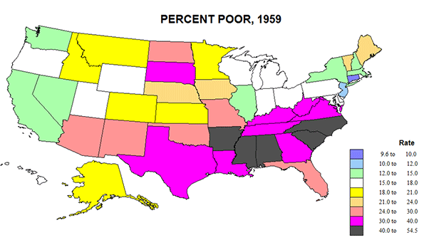
    The United States was so different in 1960, with a poor rural south and southwest, and a fairly poor Great Plains. (Figure 1). While the west coast was better off and metropolitan, the main area of lower poverty was the historic urban-industrial core from IL and WI to southern New England, where unionized industry prevailed. CT was richest with less than 10 percent poverty; this compared to MS with a poverty rate of 55! The deep south was amazingly poor and not just for Blacks. 

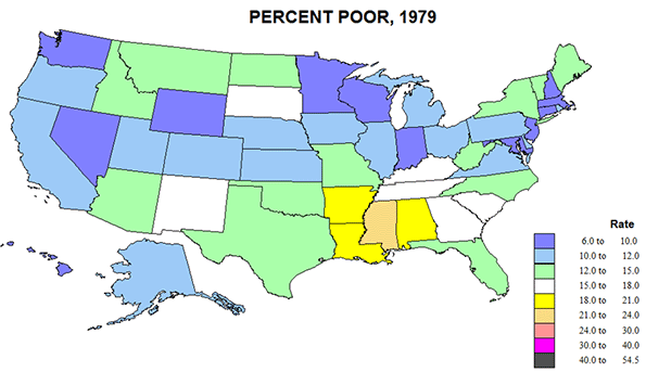
    Changes by 1979 were indeed revolutionary (Figure 2).  Areas of lower poverty extended from the old industrial core to the rest of New England and down Megalapolis to Virginia, and to the “old northwest”, MN, WI, IA, and to most of the US West. Most improved were the corners of the south, TX, OK, and FL, NC, due to energy development, new industries moving to the south and poor blacks escaping to the north.  Only a small lower Mississippi region (AR, LA, MS, and AL) remained fairly poor.

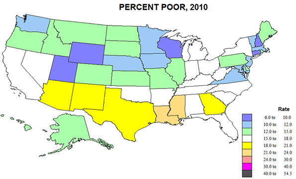
    2010 saw a rather general resurgence of poverty – related certainly to globalization and industrial off shoring, deindustrialization in the old northeastern core, and greater poverty across the southern tier from CA to FL, in part related to heavy immigration from Latin America.  Some of this shift could, in my opinion, be pegged as well to the shift to more conservative Republican Party rule.


    Numbers of States
    White Black Over 65
    Rate 1960 1980 2010   1980 1980 1980
    <12% 2 27 14 41 0 11
    12-18% 19 19 30 10 7 21
    18-24% 11 5 7 8 8
    24-40% 14 36 11
    >40% 5

    Poverty rates fell broadly between 1960 and 1980, especially for the half of states with 1960 rates above the 22% average level, while the number of states with rates below the 1980 average of 12% rose from 2 to 27 states. Rates increased modestly in the ensuing years in the then states with the lowest rates.

    The Relative Fates of States    

    Several states fared relatively best, with poverty rates falling at least in half or more in 2010 than in 1980. These are in two disparate sets: first southern states with very high poverty in 1960: AL, AR, KY, MS, NC, and VA, and another northern set  in ME, NE, NH, ND, SD, UT, and VT.  Other states in which poverty rates fell at least in half, but were lower in 1980 than in 2010 include GA, IA, SC, and TN. FL and TX poverty rates fell to less than half the 1960 rates in 1980, but poverty growth by 2010 showed some back-tracking. At the other extreme three states actually had higher rates of poverty in 2010 than way back in 1960: CA, NV, and NY.

    The particular gains for the south reflect two dominant forces, the out-migration of large numbers of black people to the north and west, slowing the reduction in poverty rates for the north and west, as well as the successful shift of industry from the north to the south, both forces including millions of families and of jobs.  TX and FL stand out because of high migration from Latin America. The exceptional story of CA and NY is similarly one of massive migration of minorities from the rest of the country but of even larger immigration from Latin America. The opposite story of very low poverty in NH, VT, and ME is one of overflow of opportunities and wealth from Massachusetts. The reason for ND, SD, NE, and UT is pre-oil development, and reflects broader forces for poverty reduction.

    Poverty in White and Black

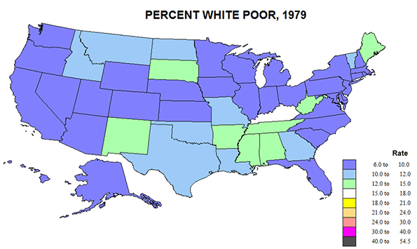
    White poverty rates fell from 17 to 9.4 in 1979 but then edged up to 10% in 2010. At the same time, black poverty rates fell from a horrendous 55% in 1959 to just under 30% in 1979 and appears to have remained at 30 in 2010. Note that black poverty rates remain three times that of whites, and are comparatively as high as they were in 1959.  The gap remains worse (Figure 6) in the south and extreme generally across the north, but much lower in places like the Dakotas and upper New England in 1979 in part because of small numbers, and also due to the fact that the 1959 rates included Native Americans while the 1979 numbers did not.  The only good estimates for white poverty were for 1979, and reveal a remarkable uniformity across much of the country, lagging slightly in Appalachia-Ozarkia. (Figure 5) 

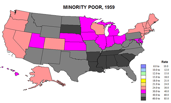
    Meanwhile, rates for blacks fell more in the parts of the South SC,  VA, NC, FL, and TX, but even more so  in the historic ”black belt” of AL, LA, MS, AR, and SC where the poverty rate dropped from 77 to 33 %. Less improvement is evident for early northern destinations of blacks from the south: NY, IL, MI, OH, and NJ, or in CA and OR.

    Please refer back to the table. While whites had rates below 12% in 46 states, for blacks the number is 0.   While 0 states had white rates above 18%, 44 states had black rates above 18%. This is shameful.  I am unable to find any positive spin for this story. The racial gap remains deeply entrenched.

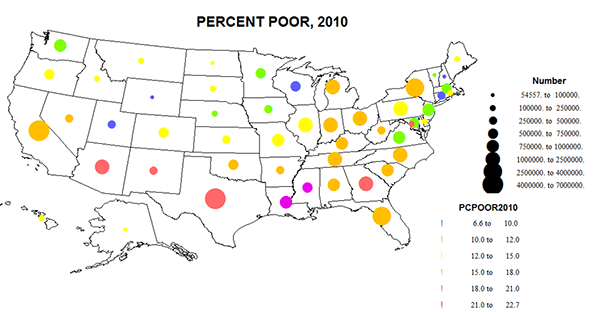
    I close with a variant of the 2010 poverty map, showing the absolute numbers as well as the rates (Figure 8). Poverty remains serious across the southern tier, especially on CA, TX and GA, but also in the north, especially in NY and the eastern Great Lakes states.  While direct causality is unlikely, one can understand the worry of the increased numbers and shares of the poor clear across the southern tier of the country- CA to FL.     

    Poverty of the Elderly

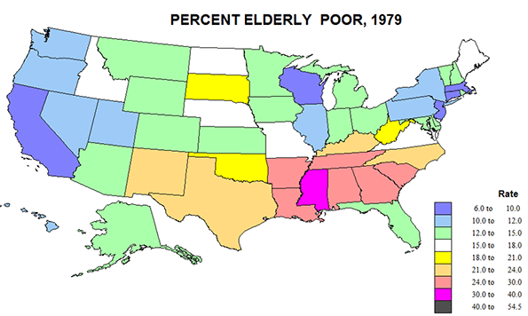
    Compared to the generally poor picture of black poverty, the story  for the elderly is much  more positive. If anyone won the “war on poverty”, it was the elderly. Is this because of their political clout? Not just that, but it obviously matters. The data for 1959 and 2010 are not fully comparable, so the only map is for 1979.  But the elderly poverty rate in 1959 was a striking 46 percent, not that much below the outcast blacks, so the fall in the rate to under 15% in 1979 is quite astonishing. The reasons for this are discussed below. Here we can compare the pattern for elderly with that for all persons.
    Actually the correlation between age and poverty is quite high; elderly rates average about 5% above those for all people.  CA, AZ, FL, and NY achieved lower senior poverty rates in 1979 than for all persons, probably a result of selective migration, perhaps a role of political influence in AZ and FL.

    Why did poverty fall so much from 1960 to 1980, and then increase again? This is no big mystery! The two powerful and complementary forces reducing poverty were America’s robust economic expansion, in the 1960s especially, combined with social programs, starting with the New Deal (especially Social Security and the minimum wage), and the era of union growth, followed by the 60s Civil Rights revolution, including women’s rights, and the Great Society’s War on Poverty, above all Medicare and Medicaid. Of course these programs had to be paid for, but this was accomplished by vast economic investment and gains in productivity of the economy.

    The elderly were a huge part of poverty in 1960 but a relatively low part by 1980.  And despite the nation’s ongoing inability to overcome racial discrimination and unrest, the social programs have greatly helped the emergence  of a black middle class, as much in the south as in the north.

    Factoring in the Cost of Living

    But wait! Isn’t the cost of living higher in New York and San Francisco than in West Virginia and Nebraska?  Should this affect the estimates of poverty across the state?  The answer is yes, and fortunately, the Census Bureau has just completed a new series of poverty estimates for 2010-2012 adjusting for variations in the cost of living, and compared these to their official figures.  The effects are not trivial.

    Essentially, the cost of living is significantly higher in the biggest, densest and richest metropolitan cores, and correspondingly lower is most of the rest of the country. The higher costs in these few giant but populous places is sufficient to raise the number in poverty nationally, by 2.6 million, raising the US rate from 15.1 to 16 percent.

    The critical states for underestimating poverty are actually few: CA, 2,750,000 more, up 7.3%: NJ, 415,000 more, up 4.8%; FL, 771,000 more, 4.1%; MD, up 195,000, up 3.3%; NV, 102,000, 3.8%; and NY, up 308,000, 1.6%. California dominates the rise in poverty, by itself adding more poor than the country as a whole.  But some other states with big metropolitan areas do not suffer this cost of living adjustment: TX, -338,000. -1.3%; OH, -252,000, -2.2%; MI, -130,000, -1.3%; IN -106,000, -1.7%; and NC, -249,000, 2.6%. I do not know that these states have in common, perhaps less stringent growth management and lower tax rates.  

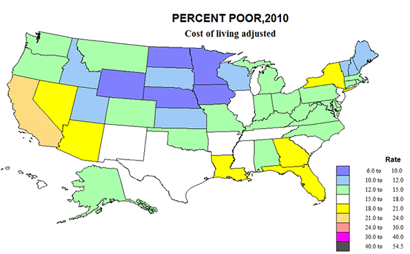
    There are seven states with a drop in the number of poor of 3% or more after adjusting for cost of living,  including MS, -136,000, -4.6%; NM, -86,000, -4.2%; WV, -75,000, -4.3%; and KY, -165,000, -3.8%.  As a consequence, we end up with a US pattern that is counter-intuitive, and contrary to conventional long-term wisdom about poverty. Big, rich mega-urban California earns the nation’s highest poverty rate as well as in total numbers (24%), followed by DC with 22.7; NV, 19.8; and FL, 19.5.  Long maligned poor states like MS has the same rate as the country, at 16%, AR, 16.5; SC, 15.8; and especially extreme, WV, 12.9 and KY, 13.6. Rather than having the lowest poverty rate at 9.6, CT moves up to 12.5, while IA, 8.6; ND, 9.2; WY, 9.2; and MN, 9.7, fall below 10% poor.  Counter-argument can be made that the story is not so different as first appears, if the richest states with higher cost of living also tend to  have higher levels of services to those in poverty. But this has not been measured. 

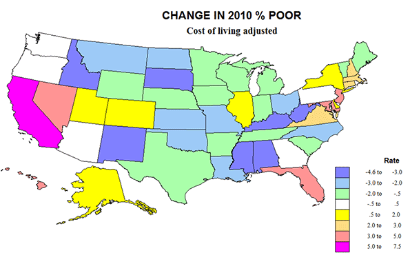
    Perusing the  two new maps of the percent poor in 2010,cost of living  adjusted, and the change in rates and numbers, highlights the key role of California-Nevada and of Megalapolis-Florida, historic cores of urban wealth, are also incubators of higher poverty. This also supports the idea that that immigration from Latin America must play a role in the heightened poverty along most of the southern border, and especially California.  The curse of poverty remains everywhere, but it’s clearly become more severe in some places, and less so in others.

    Richard Morrill is Professor Emeritus of Geography and Environmental Studies, University of Washington. His research interests include: political geography (voting behavior, redistricting, local governance), population/demography/settlement/migration, urban geography and planning, urban transportation (i.e., old fashioned generalist).

  • Go East, Young Southern California Workers

    Do the middle class and working class have a future in the Southland? If they do, that future will be largely determined in the Inland Empire, the one corner of Southern California that seems able to accommodate large-scale growth in population and jobs. If Southern California’s economy is going to grow, it will need a strong Inland Empire.

    The calculation starts with the basics of the labor market. Simply put, Los Angeles and Orange counties mostly have become too expensive for many middle-skilled workers. The Riverside-San Bernardino area has emerged as a key labor supplier to the coastal counties, with upward of 15 percent to 25 percent of workers commuting to the coastal counties.

    In a new report recently released by National Core, a Rancho Cucamonga nonprofit that develops low-income housing, I and my colleagues, demographer Wendell Cox and analyst Mark Schill, explored the challenges facing the region. Although we found many reasons for concern, the region’s overall condition and its long-term prospects may be better than many might suspect.

    Population trends

    The region’s once-explosive growth has slowed considerably. From 1945-2010, the area’s population soared from 265,000 to 4.25 million. Already the nation’s 12th-largest metropolitan area, the I.E. could pass San Francisco and Boston by 2020 (unless faster-growing Phoenix does so first).

    Yet, contrary to expectations (and, perhaps, hope among anti-sprawl campaigners), the area continues to be a beacon for people from the rest of the region. There is a notion, widely expressed in the mainstream media, that Southern California’s growth will now focus more on the urban core around Downtown Los Angeles. Yet, as is often the case, what planners and pundits desire is not widely shared by the vast majority of people.

    People continue to vote for the Inland Empire – and other peripheral areas – with their feet. Census Bureau data indicates that, from 2007-11, nearly 35,000 more residents moved from Los Angeles County to the Inland Empire than moved in the other direction. There was also a net movement of more than 9,000 from Orange County and more than 4,000 net migration from San Diego County.

    Several long-standing demographic trends favor a continued shift to the Inland region, according to Cox and Schill. Immigrants and their offspring may prove the critical factor. Over the past decade, the Inland region dramatically increased its population of foreign-born residents, more than three times the number and at nearly 18 times the rate of the coastal counties.

    The influx of immigrants and their children is largely responsible for the region’s relatively young population, compared with the rest of Southern California. As recently as 2000, the proportion of population ages 5-14 in Los Angeles and Orange counties stood at 16 percent, the sixth-highest level among the nation’s 52 largest metropolitan areas. Thirteen years later, that proportion had dropped to 12.8 percent, 33rd among the 52 largest metropolitan areas. In terms of a dropping share of youngsters, the area experienced a 20 percent reduction, the largest in the nation.

    In contrast, the Inland Empire remains a bastion of familialism, with 15.3 percent of the population aged 5-14, among the highest levels in the nation. This follows a general pattern; according to recent analysis of Census data, high-cost areas tend to repel families. Of the nation’s most expensive areas, such as the Bay Area, New York and Boston, all tend to have well below national norms in terms of families among their populations.

    Perhaps more surprising, younger educated workers also are heading to the region. In fact, from 2011-13, according to American Community Survey data, Riverside-San Bernardino witnessed the 12th-largest increase among the 52 major metro areas in the share of college-educated residents ages 25-34. No major California metro area, including Silicon Valley, could match it. From 2000-13, the Inland region experienced a 91 percent jump in population with bachelor or higher degrees, just less than twice the increase for either Orange or Los Angeles counties.

    Overall, the I.E. has become something of a growth area for millennials – basically, adults ages 20-29. San Bernardino-Riverside ranked second among 52 metro areas, adding 50,000 millennials, an 8.3 percent increase since 2010. Los Angeles and Orange counties – older, settled areas with far lower population growth – together registered 18th.

    Economic Restructuring

    These trends also may reflect improving prospects for the region’s economic recovery. The area remains some 30,000 jobs below its 2007 level, notes California Lutheran University economist Dan Hamilton, but is now growing faster than the rest of the Southland. The region created jobs over the past year at a 2.2 percent rate, well above the 2.0 percent increase in Orange County and almost twice that of L.A.’s 1.3 percent. Foreclosures have diminished to the lowest levels since 2007 and appear back to something resembling normalcy.

    One important source of new employment is grass-roots entrepreneurship. Overall, the Inland Empire accounted for a large proportion of the new businesses created statewide from 2012-13 – despite hosting only 7.4 percent of the total businesses in California. A recent report by Beacon Economics suggested that growth will accelerate over the next five years.

    At the same time, some of the core industries – such as manufacturing and warehousing – have shown signs of recovery. Industrial vacancy rates have fallen from nearly 12 percent in 2009 to roughly half that level today.

    Much of the growth has been for “middle-skilled jobs,” paying $14 to $21 per hour, including positions in medical services, trucking and customer service. Overall, according to one recent survey, the Inland Empire ranked 13th among the nation’s large metropolitan areas in creating such positions. These jobs, notes economist John Husing, are critical to a region where almost half the workforce has a high school education or less.

    Even the housing sector, the driver of the post-crash employment decline, has improved considerably. Today, the Inland Empire is experiencing a far greater increase in construction permits than either Los Angeles or Orange counties. This has also helped boost construction employment, although not to anything like the levels experienced a decade before. Construction employment, although up recently, still totals barely half the people it did in 2006.

    Some, such as University of Redlands economist Johannes Moenius, express concern that important industries, like warehousing and manufacturing, are increasingly using part-time workers. Positions paying $15,000 to $30,000 annually constitute nearly half of all new jobs.

    The ambiguity in the recovery is reflected in a recent survey by Cal State San Bernardino, which found the percentage of those saying the economy was excellent or good had almost doubled since 2010, from 9 percent to 17 percent, but this was considerably below the 40-plus percent seen before the crash.

    The Path Ahead

    The fate of the Inland Empire remains in the balance. The recovery of the region depends largely on continued widespread population growth, largely stimulated by the production of affordable housing. Yet, at the same time, state regulations, spurred on by the environmental lobby, which seeks to slow, or even eliminate, single-family construction, threaten to force up prices and drive young families outside the state.

    Many other core industries of the area – such as warehousing and manufacturing – also face growing regulatory barriers. High taxes and energy costs originating from Sacramento are particularly difficult for industries that require power to operate. Southern California Edison’s rates, for example, are almost twice those found in Salt Lake City, Seattle or Albuquerque.

    Some may celebrate these policies that encourage people to say “good riddance” to a region too sprawling and insufficiently cultured. Yet, it’s hard to see how Southern California can continue to add workers – notably, younger middle-class families – without a vibrant Inland Empire. It remains the one Southern California region with the land, and the housing cost structure, to accommodate much of the hard-pressed middle class. Without growth inland, Southern California will be largely relegated to a torpid economy and rapidly aging demographics, a fate that would compromise the aspirations of future generations.

    This piece originally appeared in The Orange County Register.

    Joel Kotkin is executive editor of NewGeography.com and Roger Hobbs Distinguished Fellow in Urban Studies at Chapman University, and a member of the editorial board of the Orange County Register. He is also executive director of the Houston-based Center for Opportunity Urbanism. His newest book, The New Class Conflict is now available at Amazon and Telos Press. He is also author of The City: A Global History and The Next Hundred Million: America in 2050.  He lives in Los Angeles, CA.

  • Looking Back: The Ideal Communist City

    Over time, suburbs have had many enemies, but perhaps none were more able to impose their version than the Communist Party of the Soviet Union. In its bid to remake a Russia of backward villages and provincial towns, the Soviets favored big cities – the bigger the better – and policies that were at least vaguely reminiscent of the “pack and stack” policies so popular with developers and planners today.

    Some of this took the form of rapid urbanization of rural areas. Under Joseph Stalin’s rule in the Soviet Union from 1929 to 1953, scores of “socialist cities” were founded near new, expansive steel mills. These steels mills were built to speed up industrialization, in order to produce vast amounts of weaponry. These, notes historian Anne Applebaum, represented the Soviet communists “most comprehensive attempt to jump-start the creation of a truly totalitarian civilization”, by bringing the peasantry into the factories to grow Russia’s working class.   Built from the ground up, these factory complexes, notes Applebaum, “were intended to prove, definitively, that when unhindered by preexisting economic relationships, central planning could produce more rapid economic growth than capitalism”.

    As is sometimes asserted by urbanists today, the new socialist cities were about more than mere economic growth; they were widely posed as a means to develop a new kind of society, one that could make possible the spread of Homo sovieticus (the Soviet man). As one German historian writes, the socialist city was to be a place “free of historical burdens, where a new human being was to come into existence, the city and the factory were to be a laboratory of a future society, culture, and way of life”.

    Elements of High Stalinist culture was evident in these cities; the cult of heavy industry, shock worker movement, youth group activity, and the aesthetics of socialist realism. This approach had no room for what in Britain was called “a middle landscape” between countryside and city. Throughout Russia, and much of Eastern Europe, tall apartment blocks were chosen over leafy suburbs. Soviets had no interest in suburbs of any kind because the character of a city “is that people live an urban life. And on the edges of the city or outside the city, they live a rural life”. The rural life was exactly what communist leaders hoped their country would get away from, therefore Soviet planners housed residents near industrial sites so they could contribute to their country through state-sponsored work.

    With this assumption, Soviet planners made some logical steps to promote density. They built nurseries and preschools as well as theatre and sports halls within walking distance to worker’s homes.   Communal eating areas were arranged. Also, wide boulevards were crucial for marches and to have a clear path to and from the factory for the workers. The goals of the “socialist city” planners were to not just transform urban planning but human behavior, helping such spaces would breed the “urban human”.

    As is common with utopian approaches to cities, problems arose. Rapid development, the speed of construction, the use of night shifts, the long working days, and the inexperience of both workers and management all contributed to frequent technological failures. Contrary to the propaganda, there was a huge gap between the ideal of happy workers thriving in well-managed cities and the reality.  

    If today’s architects sometimes obsess over the quality of production and design, the Soviet campaign to expand dense urbanism was less aesthetically oriented. Less than a year after Stalin’s death, in December 1954, Nikita Khrushchev set a campaign to promote the “industrialization of architecture”. He spoke highly of prefabricated buildings, reinforced concrete, and standardized apartments. He did not care for appearances, instead focusing on just building housing because that is what the people need. Prefab tower blocks, called Plattenbau in German and panelaky in Czech and Slovak, were constructed all over the Soviet Union and their satellite states. Originally, these apartments were to house families working for the state.

    In 1957, a group of architecture academics from the University of Moscow published a book called the Novye Elementy Rasseleniia or “New Elements of Settlement”. This team of socialist architects and planners — Alexei Gutnov, A. Baburov, G. Djumenton, S. Kharitonova, I. Lezava, S. Sadovskij— became known as the “NER Group.”  In 1968, they were invited to the Milan Triennale by Giancarlo de Carlo to present their plans for an ideal communist city. In cooperation with a group of young urbanists, architects, and sociologists, they created an Italian edition of their book under the title Idee per la Citta Comunista.    

    Alexei Gutnov and his team set to create “a concrete spatial agenda for Marxism”. At the center of The Communist City lay the “The New Unit of Settlement” (NUS) described as “a blueprint for a truly socialist city“. Gutnov established four fundamental principles dictating their design plan. First, they wanted equal mobility for all residents with each sector being at equal walking distance from the center of the community and from the rural area surrounding them. Secondly, distances from a park area or to the center were planned on a pedestrian scale, ensuring the ability for everyone to be able to reasonably walk everywhere. Third, public transportation would operate on circuits outside the pedestrian area, but stay linked centrally with the NUS, so that residents can go from home to work and vice versa easily. Lastly, every sector would be surrounded by open land on at least two sides, creating a green belt.

    Gutnov did acknowledge the appeal of suburbia — “…ideal conditions for rest and privacy are offered by the individual house situated in the midst of nature…”, but rejected the suburban model common in America and other capitalist countries. Suburbs, he argued, are not feasible in a society that prioritizes equality, stating, “The attempt to make the villa available to the average consumer means building a mass of little houses, each on a tiny piece of land. . . . The mass construction of individual houses, however, destroys the basic character of this type of residence.”

    The planner’s main concern was ensuring social equality. This was seen in their preference of public transportation over privately owned vehicles, high-density apartment housing over detached private homes, and maximizing common areas. These criticisms of suburban sprawl have some resonance in the   writings by planners advocating “smart growth” today. Both see benefits to high density housing. For one, they argue it is more equitable so everyone, no matter what social class they belong too, can live in the same type of buildings. Some New Urbanists do also like the idea of mixed-income communities. In addition, they both see their ideal community utilizing mixed-use developments, with assuring people easy access to public services such as day care, restaurants, and parks, creating less of a need for private spaces. Similarly, New Urbanists also claim that their planned developments would foster a better sense of community.

    Source: Gutnov, Alexi, Baburov, A., Djumenton, G., Kharitonova, S., Lezava, I., Sadovskij, S. The Ideal Communist City. George Braziller: New York. 1971.

    Of course, it is easy to go too far with these analogies. Even at their most strident, new urbanists and smart growth advocates do not enjoy anything like monopoly of power than accrued to Communist leaders. And also, not all the ideas of new urbanists, and even the creators of the Ideal Communist City, are without merit. The ideas of walkability, close access to amenities and services, are adoptable even in privately planned, suburban developments. But the dangers of placing ideology before what people prefer are manifest, whether in 20th Century Russia or America today.

    Alicia Kurimska is a research associate at the Center for Opportunity Urbanism and Chapman University’s Center for Demographics and Policy. She is the co-author of “The Millennial Dilemma: A Generation Searches for Home… On Their Terms” and deputy editor of New Geography, a website focusing on economics, demographics, and policy.”

    Lead photo of Krushchev-era apartment buidlings in Estonia, “EU-EE-Tallinn-PT-Pelguranna-Lõime 31” by Dmitry GOwn work. Licensed under Public Domain via Wikimedia Commons.

  • International Housing Affordability in 2014

    The just released 11th Annual Demographia International Housing Affordability Survey shows the least affordable major housing markets to be internationally to be Hong Kong, Vancouver, Sydney, along with San Francisco and San Jose in the United States. Honolulu, which should reach 1,000,000 population this year (and thus become a major metropolitan market) was nearly as unaffordable as San Francisco and San Jose. An interactive map in The New Zealand Herald illustrates the results.

    Rating Housing Affordability

    The Demographia International Housing Affordability Survey uses the "median multiple" price-to-income ratio. The median multiple is calculated by dividing the median house price by the median household income. Following World War II, virtually all metropolitan areas in Australia, Canada, Ireland, New Zealand, the United Kingdom and the United States had median multiples of 3.0 or below. Since that time, housing affordability has been seriously retarded in metropolitan areas that have been subjected to urban containment policies. This includes virtually metropolitan areas of the United Kingdom, Australia, New Zealand and some markets in the United States and Canada.

    Housing affordability ratings are indicated in Table 1.

    Table 1
    Demographia International Housing Affordability Survey 
    Housing Affordability Rating Categories
    Rating Median Multiple
    Severely Unaffordable 5.1 & Over
    Seriously Unaffordable 4.1 to 5.0
    Moderately Unaffordable 3.1 to 4.0
    Affordable 3.0 & Under


    Table 2 summarizes housing affordability ratings for the 86 major metropolitan areas in the nine nations covered. Apart from China (Hong Kong), the least affordable nation among the major markets is New Zealand, at 8.2, followed by Australia at 6.4. Both nations (and Hong Kong) are rated severely unaffordable. 

    Table 2
    Housing Affordability Ratings by Nation: Major Markets (Over 1,000,000 Population)
     Nation     Seriously Unaffordable (4.1-5.0) Severely Unaffordable (5.1 & Over)    
           
    Affordable (3.0 & Under)  Moderately Unaffordable (3.1-4.0) Total Median Market
     Australia 0 0 0 5 5 6.4
     Canada 0 2 2 2 6 4.3
     China (Hong Kong) 0 0 0 1 1 17
     Ireland 0 0 1 0 1 4.3
     Japan 0 1 1 0 2 4.4
     New Zealand 0 0 0 1 1 8.2
     Singapore 0 0 1 0 1 5
     United Kingdom 0 1 10 6 17 4.7
     United States 14 23 6 9 52 3.6
     TOTAL 14 27 21 24 86 4.2


    Least Affordable Major Markets

    Hong Kong registered the highest median multiple out of the 86 major markets and also in the history of the Survey, at 17.0. Vancouver reached 10.6. Sydney had its worst recorded housing affordability, with a median multiple of 9.8. Adjacent metropolitan areas San Francisco and San Jose had median multiples of 9.2, while Honolulu’s median multiple was 9.0. The ten least affordable major metropolitan areas are shown in Figure 1. In nine of these markets, housing was affordable before adoption of urban containment policy (Hong Kong data is not available).

    Affordable Major Markets

    All of the affordable major markets are in the United States. This includes perhaps the most depressed market, Detroit as well as Atlanta, which has spent most of the last three decades as the fastest growing larger metropolitan area in the high income world. At the same time, Atlanta has consistently been among the most affordable. Detroit’s median multiple is 2.0, while Atlanta’s is 2.9.

    Comparing Demographia Results to The Economist and Kookmin Bank

    This year’s edition includes a comparison of housing affordability multiple data from The Economist’s survey of 40 metropolitan areas in China and Kookmin Bank’s survey of major metropolitan areas in South Korea. The least affordable major markets are in China, New Zealand and Australia, all with severely unaffordable median multiples. The most affordable major markets are in the United States and Korea, both rated as moderately unaffordable (Figure 2).

    Perspective

    Hugh Pavletich, of performanceurbanplanning.com and I have published each of the annual editions, which began in 2005. The perspective of the Demographia International Housing Affordability Survey is that domestic public policy should, first and foremost be focused on improving the standard of living and reducing poverty. This requires policies that facilitate both higher household incomes and lower household expenditures (other things being equal). Housing costs are usually the largest component of household expenditure and it is therefore important that public policy both encourage and preserve housing affordability.

    Housing Affordability and Urban Containment Policy

    However, in recent years, land use policy has not been focused on this concern. Conventional urban theory sees urban containment as a necessity. Yet, urban containment policies are associated with the loss of housing affordability, due principally to their rationing of land for development. This effect is consistent with basic economics – restricting supply of a desired good tends to drive up prices – that has been long established.

    Some of the most important contributions have come from Sir Peter Hall, et al (see The Costs of Smart Growth Revisited), Paul Cheshire at the London School of Economics (New Zealand Seeks to Avoid "Generation Rent") and William Fischel at Dartmouth University (The Consequences of Smart Growth). Donald Brash, former governor of the Reserve Bank of New Zealand attributed the housing affordability losses to "the extent to which governments place artificial restrictions on the supply of residential land" in his introduction to the 4th Annual Edition.

    The Importance of Urban Expansion

    This year’s introduction is provided by Dr. Shlomo Angel, leader of the New York University Urban Expansion Program. Dr. Angel reminds us that "where expansion is effectively contained by draconian laws, it typically results in land supply bottlenecks that render housing unaffordable to the great majority of residents."

    He describes the Urban Expansion Program is "dedicated to assisting municipalities of rapidly growing cities in preparing for their coming expansion, so that it is orderly and so that residential land on the urban fringe remains plentiful and affordable." Urban Expansion Program teams are already working with local officials in Ethiopia and Colombia to achieve this goal. Angel’s previous work documented the association between urban containment policy in Seoul and large house price increases relative to incomes (see Planet of Cities).

    Policies seeking the same goals of plentiful and affordable land on the urban fringe are just as necessary in high income world metropolitan areas.

    As time goes on, the negative consequences of urban containment policy on housing affordability and the standard of living have been increasingly acknowledged. Christine Legarde, managing director of the International Monetary Fund said that "supply-side constraints will require further measures to increase the availability of land for development and to remove unnecessary constraints on land use." in a recent statement on housing affordability in the United Kingdom.

    Similarly a recent feature article in The Economist (see PLACES APART: The world is becoming ever more suburban, and the better for it) noted that the only reliable way to stop urban expansion was to stop them forcefully (such as through urban containment policy). Yet, The Economist continued, "But the consequences of doing that are severe" and cites the higher property prices that have been the result:"

    The Economist continued to note the effect of the policy on households: "It has also forced many people into undignified homes, widened the wealth gap between property owners and everyone else…"

    Wendell Cox is principal of Demographia, an international public policy and demographics firm. He is co-author of the "Demographia International Housing Affordability Survey" and author of "Demographia World Urban Areas" and "War on the Dream: How Anti-Sprawl Policy Threatens the Quality of Life." He was appointed to three terms on the Los Angeles County Transportation Commission, where he served with the leading city and county leadership as the only non-elected member. He was appointed to the Amtrak Reform Council to fill the unexpired term of Governor Christine Todd Whitman and has served as a visiting professor at the Conservatoire National des Arts et Metiers, a national university in Paris.

    Photo: Exurban London

  • Dr. Strangelove: Or How I Learned To Stop Worrying and Love Sprawl (Sort of)

    I’m a longtime advocate of walkable, mixed-use, mixed-income, transit-served neighborhoods. But lately I’ve been having impure thoughts about suburbia. Let me explain.


     Screen Shot 2015-01-06 at 8.45.12 PM Screen Shot 2015-01-06 at 8.43.39 PM

    What often passes for a neighborhood in America is a low grade assemblage of chain convenience stores, big box outlets, franchise muffler shops, multi-lane highways, and isolated cul-de-sacs. Even when it’s physically possible to walk or bike from Point A to Point B it’s not pleasant, safe, or convenient. I bet there are big parts of the town you live in that look like this.

    Screen Shot 2015-01-06 at 8.46.09 PM Screen Shot 2015-01-06 at 8.46.24 PM Screen Shot 2015-01-06 at 8.54.45 PM

    Here’s what’s happened to the housing stock in previously desirable post war suburbs. They’ve aged and were passed over in favor of new development farther out on the edge of town. The homes are out of fashion. They’re too small. They don’t have the right modern features. There are questions about the quality of the local schools. And there’s a general perception that the kinds of people who remain may not make good neighbors. These properties sell at significantly lower prices relative to the larger region. It’s often assumed that they’re unlikely to appreciate in value so they’re considered a poor investment.

    Screen Shot 2015-01-06 at 8.42.30 PM Screen Shot 2015-01-06 at 8.47.44 PM Screen Shot 2015-01-06 at 9.15.26 PM Screen Shot 2015-01-06 at 8.43.09 PM Screen Shot 2015-01-07 at 1.35.38 AM

    This is what the commercial building stock is like. Cheap disposable plywood and cinder block boxes and industrial sheds set behind a patch of asphalt parking lot. These photos happen to be of Portland, Oregon, but they could be from a thousand other places. They’re all the same. This actually looks a lot like where I grew up in New Jersey.

    Sure, the sleek new Pearl District and Historic Pioneer Square are fashionable and urbane. But the vast majority of people will never live there. Most of Portland, like most of America, is sprawl. Forget what you’ve heard about urban growth boundaries, streetcars, and jack booted liberal thugs who make you live in a shoebox apartment and take away your car. The reality on the ground is that most of Portland is indistinguishable from everyplace else.

    Screen Shot 2015-01-07 at 1.34.34 AM Screen Shot 2015-01-07 at 1.44.53 AM

    But here’s the fascinating thing to me – and the source of my recent epiphany about aging sprawl. I always assumed that these neighborhoods would all devolve into the new slums – and many certainly are doing that. Ferguson, Missouri anyone? But it doesn’t have to go that way. These forgotten suburban neighborhoods can just as easily be the new sweet spots for small enterprise and a renewed middle class.

    I stumbled on the intersection of 42nd Avenue and Killingsworth (see all photos above) and thought, “What a crap hole.” But then I started to poke around for a couple of weeks. There’s more going on than immediately meets the eye.

    Here’s the deal. In the 1970’s and 80’s the cheapest real estate was in America’s abandoned downtowns and industrial zones. They were colonized by people looking for freedom – economic freedom from high rents and mortgages, as well as regulatory freedom to do as they wished without the Upright Citizen’s Brigade shutting them down. Now those places have all been picked over by high end developers and transformed into luxury “lifestyle” centers. The same is true of many close-in historic streetcar suburbs like Portland’s Alberta Arts District here. So if you either can’t afford, or simply don’t want, the premium city condo or the deluxe outer suburb McMansion… where do you go to do your own thing on a tight budget?

    IMG_3094 (800x533) IMG_3115 (800x533)   IMG_3122 (800x533) IMG_3126 (800x533) IMG_3109 (800x533)

    This is Pollo Norte here on a miserable intersection where two busy roads collide. A friend brought me here for take away dinner one night and the food was simple, but spectacularly good and it was served by charming people. We arrived at 6:30 on a Tuesday and the place was packed. We were lucky to get the last whole chicken and some side dishes just as they sold out. The place is open until ten but they were overwhelmed by many more customers than they expected. This was their first month in business and they couldn’t keep up with demand. Aside from the great food, the customers all seemed to know each other and were in good spirits even though there wasn’t enough food to go around. They were celebrating the success of a great new local spot. Good beer and companionship were their consolation prizes. Now the owners need to ramp up production and work with their local suppliers to obtain more of the organic free range ingredients in keeping with their mission statement about quality and regional sustainability. This is a good problem for a new business to have.

    Screen Shot 2015-01-07 at 1.01.19 AM Google

    By the way, I pulled this image off Google Street View. This is what the building looked like before the Pollo Norte folks scrubbed it clean, gave it some paint, and infused it with new life. It’s still a piece of crap concrete block bunker, but these buildings can be reinvented to good purpose with the right attitude and community support.

    unnamed-9 unnamed-10 unnamed-11 unnamed-12 unnamed-13
     unnamed-14

    Here’s another tiny concrete bunker a few blocks down the road. It’s owned by a woman who runs a 550 square foot commercial kitchen called Dash here. She rents out space to a variety of small scale producers who need an inspected facility in order to comply with health codes. When I dropped in I was able to speak with Nikki Guerrero as she was readying her Hot Mamma Salsa for market in local shops. here. Nikki started out selling small batches of salsa at farmers markets and now has expanded to several local grocers. She’s successful enough to support herself with the salsa. I don’t think Dash was intentionally organized as an incubator per se, but it serves as the next step up after people are ready to graduate from home cooking (Oregon has a cottage food law here) and street vending. This is not only profitable for the woman who owns the building and cost-effective for people who rent space, but it also cultivates community among various small business people as they share the space. The beauty of this business model is that any cheap ugly building in any uninspiring location can work so long as zoning and NIMBYs don’t get in the way. When your neighbors are industrial sheds and no name convenience stores you don’t get any push back.

    unnamed unnamed-1 unnamed-3 unnamed-4 unnamed-2
    unnamed-5

    Miss Zumstein’s Bakery across the street here is owned by Anja, a native Portlander who finds it difficult to afford property in the trendy parts of town now that the city has become much more expensive than in her girlhood. She recently opened her bakery/cafe on 42nd Ave. because so many of her friends have recently colonized the neighborhood. Price has pushed people into places to live that they wouldn’t necessarily have chosen otherwise. Now the big task at hand is how to make the ugly traffic corridor a proper walkable Main Street on a tight budget. She said the new Pollo Norte is a great indication of the kinds of small independent businesses she’s working with to carve out a new business zone in an otherwise not-so-great location. Anja was very supportive of the people at Dash (Hot Mama Salsa et al) and was thrilled that a new bicycle shop opened up nearby. Cheap ugly space and lots of enthusiastic like-minded people are their primary resources. 

    unnamed-16  unnamed-18 unnamed-20 unnamed-19 unnamed-21

    This is Cat Six Bikes here. Two bike guys just opened up shop seven months ago. They were working for someone else in a more established neighborhood and finally decided to do their own thing. There are so many cyclists in Portland that if there’s a three mile stretch without a bike shop it’s actually a problem for a lot of people who need parts and service. They identified this location, realized it was more affordable than other more fashionable parts of town, and decided to fill the need.

    They almost rented the building that the Pollo Norte people are in now, but the current location was ultimately a better deal. The dentist who owns the building and runs his practice next door provided a deep discount on the rent because he lives in the immediate neighborhood and wanted to help establish more independent businesses in the area. The alternative probably would have been a check cashing place or a cell phone outlet. The guys were able to pull together their business and populate their initial stock and equipment for $10,000 which they had in savings. There was no need for a loan. They’re both handy and were able to do the carpentry and interior work for the shop themselves.

    Screen Shot 2015-01-07 at 1.54.40 AM GoogleScreen Shot 2015-01-07 at 1.57.11 AM GoogleScreen Shot 2015-01-07 at 1.52.51 AM 
    GoogleScreen Shot 2015-01-07 at 1.55.31 AM GoogleScreen Shot 2015-01-07 at 1.50.09 AM GoogleScreen Shot 2015-01-07 at 1.56.17 AM GoogleScreen Shot 2015-01-07 at 1.51.55 AM Google

    But here’s the other thing they mentioned that got me exploring the rest of the neighborhood. The guys share a house – one lives with his girlfriend upstairs and the other lives downstairs. The house is nearby in the Cully neighborhood where little post war homes often have pretty large lots. Many neighbors do varying degrees of urban agriculture – some for a livelihood. This is absolutely not an option in the city center.

    Of course they ride their bikes to work since things are relatively close compared to the far more disbursed newer suburbs far from the downtown core. They were confident that over time they would be able to convince the city to implement road diets that would calm car traffic and make it safer and more pleasant to walk and ride bikes in the area. The primary factor in their favor is that highway expansion and car-oriented improvements are fantastically expensive, while bike infrastructure is ridiculously cheap. They also decided that what the neighborhood lacks in big city urban amenities it makes up for in gardening and door-to-door domestic community as well as significantly lower cost. Many of their friends had already moved to the area so they weren’t alone.

    IMG_2632 (800x533) IMG_2635 (800x533) Screen Shot 2015-01-08 at 9.42.51 PMIMG_3561 (800x533)IMG_3566 (533x800)

    And what about all those tragic little post war ranch homes? Well, it turns out that they’re radically less expensive than either a condo downtown or a McMansion in the newer suburbs. With a little love they can be transformed into something to be proud of. They’re bigger than an apartment, they have a garden, and they’re a whole lot closer to the city center. They’re also a short walk or bike ride to the emerging 42nd Ave, business cluster.

    I’m not saying that all, or even most, aging suburbs will blossom. But it’s at least a possibility. The real question to me is… what pushes a neighborhood down vs. what lifts it up? So far what I’m seeing is that a dead downtown contributes to even deader close in neighborhoods. A thriving downtown attracts more people to the city and creates an economic incentive for people to get creative with the reinvention of not-so-fabulous nearby areas. So if you want your struggling suburb to succeed, support your downtown.

    John Sanphillippo lives in San Francisco and blogs about urbanism, adaptation, and resilience at granolashotgun.com. He’s a member of the Congress for New Urbanism, films videos for faircompanies.com, and is a regular contributor to Strongtowns.org. He earns his living by buying, renovating, and renting undervalued properties in places that have good long term prospects. He is a graduate of Rutgers University.

  • Central Florida: Stepping Into Deep Density

    Florida is on track to break the 20 million population mark by 2016, or possibly even this year. The Sunshine State will displace New York as the third most populous state in the country, just behind California and Texas. Nationally, rural counties absorb a lot of newcomers of modest income or fixed income seeking affordable places to live. Here in Orlando, however, banks and developers are betting big on a newfound taste for the urban lifestyle, beckoning new arrivals with hip-looking apartments and parking garages, often coupled with shopping plazas full of pricey, name-brand retailers. This is a gamble of huge proportions. Regrettably, it’s just another bubble waiting to burst.

    North of downtown Orlando, two commercial corridors wind through various towns. Orange Avenue is Orlando’s version of Main Street (below: high density housing with a view of Interstate 4, Orange Avenue, and Highway 50 in Orlando, the three busiest roads in town).

    Six new multifamily projects here are open or nearly completed. These are mid-rise buildings, four stories or greater, taking advantage of downtown’s proximity. Of course, each of these structures sports a new parking garage, acknowledging that our love affair with the car is still going strong.

    US 17-92 is an even larger, 4-lane commercial strip running from downtown all the way up through Winter Park, Eatonville, Maitland, Altamonte Springs, Longwood, and beyond. It’s an Orlando version of Broadway, linking multiple neighborhoods and districts. It’s also a traffic-choked crawl, best to be avoided at certain times of the day. Nevertheless, three mid-rise apartment blocks loom over the cars, a high-rise senior living building is open for retirees, and several more are in the works (see below, at a rare, quiet moment. Still, this mock-historical apartment complex holds the street line).

    Each one of these developments ventures deeper and deeper into urban renewal territory, looking for the market’s edge. A recent proposal will displace warehouses along Orange Avenue, but is still firmly entrenched on the more profitable side of the railroad tracks. All of these developments take old or underperforming suburban sites and convert them into new, higher density blocks. The city, it seems, has finally triumphed in the battle for the hip and the cool.

    And it is a victory of sorts, at least for the short term. Each lender who funds a suburban infill project saves, for the time being, a greenfield exurban parcel that might otherwise have been chosen for the project. Florida is a state with a remarkably stressed natural environment, and these projects keep people close to the action, reducing the need for future corridors in the wilderness.

    Before the closing credits roll, however, the long-term impacts of these developments bear a closer look. While cities clap their hands for urbanism and the tax dollars it brings in, local citizens quite sensibly ask certain pointed questions… like, ‘what about traffic’? None of these new residents will do without a car, and at least one local development, approved blithely by municipal officials, now frustrates drivers for blocks around. More of the same is coming.

    Symptomatic, perhaps, of the current economy’s consumer weakness, most of these projects displace local producer activities. Instead of protecting home-grown businesses, municipal power has hastened their demise, driven by a real estate market which judged that they were not contributing to the economy at a high enough level. Gone are local commercial artists, two local sawmills and lumberyards, and a local hotel, all of which were net producers in the local economy.

    What has come in their place are yet more grocery stores — the adjacent grocery store is always a part of the formula — more hair salons, and name-brand apparel shops. Minimum-wage workers, many working for tips, now stand at cash registers where once business owners and entrepreneurs stood. These local independent businesses close down, or scatter to the more affordable periphery, which is becoming home to a new sprawl of producers. Shipping giant Amazon, for example, just completed a large facility in Florida. Near its customers in a metropolitan area?

    Nope: in rural Ruskin, locally famous for its beefsteak tomatoes. Elsewhere, local entrepreneur Carola Seminario, manufactures cosmetics in suburban Plantation, Florida, inland from Ft. Lauderdale. These businesses are far away from the dense urban core that traditionally hosted new business ventures. Like England, lampooned for becoming a “nation of shopkeepers” in the expansionist Victorian era, Florida’s urban population is becoming a reef of retail clerks and restaurant servers laboring for franchise bosses.

    In the meantime, Office occupancy rates are at a ghastly low in Central Florida, so urban development of office space is anemic. Instead, our oversupply of retail outlets just seems to keep rising. The multistory apartment stack, perched over a retail/restaurant base, has become a copy and paste routine. None of the tenants are local, independent retailers, either; the triple-net lease is only affordable to big national brands. Density is a game only the big boys can play, it seems.

    With Central Florida’s new commuter train rolling through town, the density might make some sense. But land value around rail stops has spiked in anticipation. Instead, development is occurring in the soft pockets of town, places where older, overlooked properties can be assembled with a minimum of fuss and cost. The result is that none of the new multifamily locations are really walkable to a train station. Hence, huge parking garages.

    After the applause has died down, a flush of new apartment dwellers may soon find out that a mortgage payment outside of the central city wouldn’t have been much higher than the monthly rent in town. Most people with kids, or planning for them, believe that raising them in apartments isn’t much fun. Grass, literally, is always greener. Meanwhile, Orlando cannibalized its local economy in a rush to approve these places, and became just another bland, warm commercial amalgam not much different than anywhere else in the southeast.

    By the time the city’s changes are fully visible, the transformation will be complete. Central Florida will have lost independent businesses to a miasma of ubiquitous name-brand franchises. A few service jobs will have been created, but the real careers are in corner offices of the chains’ corporate headquarters, way beyond the reach of Orlando’s residents. Rental rates will decline as growth stretches the market for a limited number of connoisseurs of the high-density lifestyle, and a gradual, insidious wealth disparity creates a new urban poor.

    The only vision, however, may be hindsight. After the bubble has burst, high density housing will remain. City planners have already begun rearranging infrastructure around this supposed densification: school boards, for example, are consolidating K-8 schools in anticipation of this new population. Urban planning, however, has to be measured in decades. School district planning, a long, slow, consensus-driven political process, takes years to implement. By the time a new school might open for the children in these places, the demographics might have shifted once again.

    Density is good in principle. It can breed efficiency, intensify business, and make a town throb with life. But in practice today, it seems to hollow out parts of the city. Dad doesn’t work on the ground floor of the apartment block; he drives to work, just like in the suburbs. Mom doesn’t hang around all day watching the kids and baking cookies; she drives to work also. The sidewalks aren’t filled with pedestrians on their way somewhere, cars slip in and out of garages, silently activating gate arms, and the kids are safely ensconced in front of electronics, not playing outside down below.

    The pricey tenant space on the ground floor doesn’t house local bakers, tailors, or professionals that live up above. Instead it houses a few minimum-wage store clerks scanning merchandise. The building form resembles this turn-of-the-century dream state — often stylistically, as well as functionally — but it’s a monstrous hybrid of the old and the new. Localism is traded away, and in its place a new feudalism, where remote landlords control vast segments of the urban realm, takes its place. With Florida’s population growth, there will still be places to prosper, but they seem less and less likely to be in the metropolis.

    Richard Reep is an architect with VOA Associates, Inc. who has designed award-winning urban mixed-use and hospitality projects. His work has been featured domestically and internationally for the last thirty years. An Adjunct Professor for the Environmental and Growth Studies Department at Rollins College, he teaches urban design and sustainable development; he is also president of the Orlando Foundation for Architecture. Reep resides in Winter Park, Florida with his family.

    photos by the author

  • Don’t Boost Cities by Bashing the ‘Burbs

    There is nothing like a trip to Washington, D.C., to show how out of touch America’s ruling classes have become. I was in the nation’s capital to appear on a panel for a Politico event that – well after I agreed to come – was titled “Booming Cities, Busting Suburbs.”

    The notion of cities rising from the rotting carcass of suburbia is widely accepted today by much of our corporate, academic and media leadership. This notion has been repeatedly embraced as well by the Obama administration, whose own former secretary of Housing and Urban Development declared several years back that the suburbs were dying, and people were “moving back to the central cities.”

    Some on Wall Street also embrace this notion. Having played a pivotal role, along with regulators, in the housing crash of the late 2000s, some financiers have been buying up foreclosed homes for rental income and also back many high-density projects, which are built to house, in large part, those who cannot buy a home, particularly the younger generation.

    As the Economistrecently pointed out, the suburban house, or a house in less-crowded parts of cities, is an aspiration of upwardly mobile people in the United States and around the world. Surveys, including those conducted by Smart Growth America, demonstrate that the vast majority of Americans prefer single-family houses; most millennials seem to feel that way, too, according to both a Frank Magid Associates survey and a more recent one from Nielsen. As the economy improves, and the people in the millennial generation enter their thirties, it is likely that they – as did other generations – will start buying houses as they start families.

    At the very least, suburbia clearly predominates among Americans. Roughly 85 percent of people in our major metropolitan areas, notes demographer Wendell Cox, inhabit suburban neighborhoods, dominated by cars and single-family houses, even though they live within the boundaries of the largest cities. They are definitively not moving en masse into the urban core. In the most recent census, from 2010, the urban core, defined as territory within two miles of city hall, grew by 206,000 people. In contrast, areas 10 or more miles away from an urban center grew by some 15 million people.

    Nor has this appreciably changed over time. Since the housing bust, the growth rates of core cities and suburbs are now basically even, but the preponderance of suburban population means that the periphery is adding many more people. From 2010-13, the suburbs added 5.4 million people, while the core cities have added 1.5 million, accounting for less than 30 percent of all major metropolitan population growth.

    Other recent analyses, such as from the real estate website Trulia, confirm that this pattern continues. Meanwhile, demand for suburban office space, often seen as dying by urban boosters, now is recovering faster than that of the central core, according to the consultancy CoStar.

    The boom in U.S. energy production, and the resulting drop in energy prices, could accelerate the suburban recovery. For years, smart-growth advocates counted on pricey “peak oil” to turn suburbs into “remote slums.” Brookings has estimated that every 10 percent rise in oil prices lowers suburban housing prices by several thousand dollars while raising prices closer in. Not surprisingly, cheaper energy does not sit well with the progressive clerisy, as epitomized by a recent New Yorker article, which likens it to “an industrial form of crack.”

    No one buys the mindless embrace of higher housing density and expanding rail transit more than urban mayors. At the Politico event in Washington, Salt Lake City Mayor Ralph Becker insisted gamely that transit is “less expensive” than building and maintaining roads, which is not even remotely the case. Transit’s fully loaded capital and operating expenditures per passenger mile are more than four times that of the automobile and road system. Nor is the Salt Lake City area about to become a region of strap hangers: 3.2 percent of workers in the Salt Lake City region commute by transit, down slightly since 2000.

    The real Salt Lake City, Becker’s perception notwithstanding, is very much a sprawled one. The downtown may have been spiffed up a bit, largely due to a massive investment by the Mormon church, but, since 2010, the periphery has grown by 48,000 people, compared with 5,000 in the city. In 1950, Salt Lake City accounted for 66 percent of the region’s population; today that is a mere 17 percent.

    Another of my fellow panelists, Atlanta Mayor Kasim Reed, is fantastical in his embrace of transit and the future of metropolitan geography. Reed counts on millennials transforming his city, but, overall, the millennial population share in urban cores has dropped since 2010, with strong percentage declines registered in such varied core counties in New York, San Francisco, St. Louis and Washington, D.C., as well as Atlanta.

    Reed, something of a darling of the Davos crowd, presides over something around 8 percent of the Atlanta metro area’s population, down from half in 1950. The most recent estimates from the Census Bureau, suggest that Atlanta may have gained 28,000 people since 2010, compared with 209,000 gained in the suburbs. But even this must be taken with a grain of salt; in the most recent census, it turned out that estimates in many cities, including New York, Chicago and St. Louis, were greatly inflated – in metro Atlanta’s case, by over 100,000.

    Although poverty has seeped out of central Atlanta and into the periphery, in part due to the relatively small size of its urban core, the poverty rate in the city is close to twice that of the suburbs, which mirrors the national trend. Its crime rate ranks among the nation’s worst, up there with Detroit, Oakland and St. Louis. An Atlanta resident is roughly more than three times more likely than an average Georgian to become the victim of a violent crime. Although worse than most, Atlanta’s metropolitan core is not unusual; overall, the rate of violent crime in urban cores, although down from 2001, is almost four times higher than that of suburbs, where the rate has also declined.

    Nor is Atlanta about to turn into a Southern version of successful transit “legacy” cities like New York or even Washington. Despite a massive investment in rail transit, the regional share of transit commuting today, according to Census Bureau estimates, is a mere 3.1 percent, compared with 3.4 percent in 2000. In reality, transit ridership has risen mostly in a handful of “legacy” cities, notably New York, while overall the share of transit commuters nationally is almost a whole percentage point lower than in 1980. In most U.S. metropolitan areas, including Atlanta, more people telecommute than take transit.

    To be sure, Atlanta is, in certain spots, looking better. Upscale districts, like Midtown and Buckhead, have rebounded smartly from the real estate crash, but downtown Atlanta has among the highest vacancy rates in the country. The once-ballyhooed Underground Atlanta downtown shopping and entertainment district is widely seen as something of a disaster. Progressive rhetoric aside, Atlanta, according to the liberal Brookings Institution, has the greatest income inequality of any large city in America, even worse than luxury cities like San Francisco, New York or Boston.

    To be sure, one can still make a sounder case for Atlanta’s evolution. There is a sizeable youth demographic, particularly students and childless households, who are attracted to such places, and some companies find the central location better than that of the suburban periphery. It is still a liveable city with many nice, relatively low-density neighborhoods that could accommodate middle-class families. It possesses a canopy of trees – leading some to call it “a city in a forest.”

    Cities like Atlanta are important, and it’s great that they are doing better than they were three decades ago. But the urban turnaround, more tentative in places like Atlanta than in Manhattan, does not have to be predicated, as the Politico event seemed to suggest, on the projected ruin of suburban aspirations. Despite the hopes nurtured in places like Washington, D.C., and among parts of financial oligarchy, suburb-dwelling Americans are likely to dominate our housing market, economy and demography for generations to come.

    Rather than target suburbia for extinction, cities should focus on the hard work ahead of them. Even as pundits worry about the loss of artists in high-cost cities, the urban future really depends on holding onto middle-class families and millennials as they age. To keep them, mayors need to focus not just on the densest sections of the urban core and rail transit, but on improving the roads, reducing crime, improving both neighborhoods and the broad-based economy. And they must radically reform the schools, critical to luring middle-class families with children. Rather than celebrating the supposed demise of suburbia, city leaders like Mayor Reed should take heed of the biblical injunction: “Physician, heal thyself.”

    This piece first appeared at the Orange County Register.

    Joel Kotkin is executive editor of NewGeography.com and Roger Hobbs Distinguished Fellow in Urban Studies at Chapman University, and a member of the editorial board of the Orange County Register. His newest book, The New Class Conflict is now available at Amazon and Telos Press. He is author of The City: A Global History and The Next Hundred Million: America in 2050. His most recent study, The Rise of Postfamilialism, has been widely discussed and distributed internationally. He lives in Los Angeles, CA.

  • Towns With a Past, Towns With a Future

    Over the last fifty or sixty years most towns have been dedicated to accommodated cars in order to cultivate business and permit people to live better more convenient lives. For new developments out in a former corn field this was effortless since everything was custom built with the automobile in mind. But older towns that had been built prior to mass motoring were at a distinct disadvantage.

      Screen Shot 2014-12-04 at 12.57.53 AM Screen Shot 2014-12-05 at 1.15.13 AM Screen Shot 2014-12-05 at 1.16.43 AM

    In order to keep up with changing times older neighborhoods, particularly older Main Street business districts, did whatever possible to retrofit themselves. The roads were widened, sidewalks were narrowed, street trees were removed, obsolete buildings were torn down to make way for parking lots, new zoning regulations and building codes were introduced to ease traffic and ensure abundant free parking. Unfortunately for many historic towns there simply was no contest. New strip malls and office parks could provide endless free parking and massively wide roads. If you add in the competition from big box national chains and the politics of race and class driving people across municipal borders for lower taxes and segregated school districts… Main Street never had a chance. The irony is that the more towns tried to accommodate cars the less pleasant they became.

    Screen Shot 2014-12-03 at 10.31.41 PM Screen Shot 2014-12-03 at 7.00.56 PM Screen Shot 2014-12-05 at 1.06.03 AM
    Screen Shot 2014-12-03 at 10.33.08 PM Screen Shot 2014-12-05 at 12.31.52 AM
    Screen Shot 2014-12-05 at 12.32.11 AM
    Screen Shot 2014-12-03 at 11.14.20 PM Google Earth

    This is a Google Earth image of the area around Cheviot, Ohio. The people of Cheviot self-identify with the fictional 1950’s TV town of Mayberry made famous by The Andy Griffith Show. It really is a lovely place, but it effectively has no business district anymore thanks to the Western Hills Plaza Shopping Center half a mile away which straddles Green Township and the Westwood district of suburban Cincinnati. Harrison Avenue, Cheviot’s century old Main Street, is circled at top right. Western Hills Plaza is circled at bottom left. The Home Depot, Target, Kroger, and Dillard’s make it impossible for mom and pop shops on Harrison Avenue in Cheviot to sustain themselves. Half the shops are empty and the others limp along. It’s a shame, because Cheviot is a charming town full of great old commercial buildings and solid housing stock. It’s a good town full of good people. The German Catholics who settled and built this part of Ohio have managed to hold on to a fair-to-middling set of arrangements through the worst years of decline, but the town is a shadow of its former self. It has excellent bones, but the flesh is sagging through no fault of its own.

    Screen Shot 2014-12-03 at 11.22.36 PM Screen Shot 2014-12-03 at 6.47.29 PM IMG_9387 (800x600) Screen Shot 2014-12-05 at 1.12.50 AM

    However, Cheviot has one thing that Western Hills Plaza doesn’t – a walkable, bikable, fine-grained pleasant neighborhood. That may not sound like much, but it’s more than nearly anyplace built after 1950 anywhere in North America can boast. Cheviot is an actual town, not just mindless suburban sprawl. That’s a rare commodity these days and a lot of people are hungry for it. Just about every home in Cheviot is within a five or ten minute walk of the old business district, local public schools, library, churches, and parks. It has become unusual in America for people to live in this kind of environment and it’s coming back in fashion with increasing demand and limited supply. There’s an opportunity here for people with the right attitude.

    Screen Shot 2014-12-04 at 1.09.07 AM Screen Shot 2014-12-04 at 1.08.19 AMGoogle Earth

    In contrast let’s say that you lived here on this cul-de-sac in Green Township and you wanted to go to one of the fast food places directly behind your back fence. This is the route you’d need to take.

    Screen Shot 2014-12-04 at 1.10.14 AM Google Earth

    If you’re used to driving everywhere everyday you might not think twice about hopping in the car. In fact, you might not even realize that the Burger King and KFC are so close. But if you were somehow forced to walk one day you might be surprised at how hard it would be given all the walls, fences, and drainage ditches that stand between you and your fast food. And the walk would be a miserable and potentially dangerous experience. The highway and its cavalcade of concrete and plastic bunkers is so wretched when you aren’t in a car that developers and city planners go out of their way to keep homes as isolated and buffered as possible. This radical separation of uses makes perfect sense in a car-oriented environment. Who wants to look out at a highway strip mall from the back yard? But it’s Hell on foot. And don’t even think of riding a bike. You’ll either get hit by a speeding car or attract the attention of the local police who will immediately identify you as a deviant. Being a pedestrian or cyclist in this environment constitutes “probable cause”. You must be unsavory if you lower yourself to such desperation here. Sitting at a bus stop in this setting is no joy either.

    Screen Shot 2014-12-04 at 12.51.28 AM Screen Shot 2014-12-04 at 12.53.48 AM Screen Shot 2014-12-04 at 12.23.18 AM Screen Shot 2014-12-04 at 12.55.51 AM IMG_9626 Screen Shot 2014-12-05 at 1.14.48 AM

    So here’s the challenge of the next few decades. The aging sprawl in Green Township and similar nearby post war suburbs like White Oak, Sharonville, and Deer Park on the edge of Cincinnati aren’t aging well. Their roads and sewer systems are right at the point where they need complete overhauls and there’s no money for any of it. Don’t expect Columbus or Washington to send big checks because they’re broke too. The housing stock in these places is neither charming in a Norman Rockwell sort of way, nor sufficiently Mad Men modern. Their roofs, windows, kitchens, baths and furnaces all need replacing right about now and there isn’t a lick of insulation in most of them. Fifty years ago these suburbs were white middle class havens with their backs to inner city decay and race riots.

    IMG_6149 (800x533) IMG_6126 (800x533) IMG_6164 (800x533) IMG_6155 (800x533) IMG_6128 (800x533)

    Now newer more prosperous suburbs Like Mason and Beavercreek farther out attract wealthier residents looking for larger homes with all the latest bells and whistles along with premium public schools and lower taxes. Green Township has less than half the average family income of Mason. Homes in Green Township and other similar areas sell for $75,000 although many homes can be found for considerably less. Mason homes sell for north of $250,000 with many at much higher price points. Meanwhile downtown Cincinnati and Over-the-Rhine are rapidly gentrifying as people who prefer an urban environment reinvigorate long abandoned neighborhoods. The poor are being displaced in the process and they’re going to have to live somewhere. Given the trajectory of these shifts it isn’t looking good for the so-so suburbs in the middle distance. We can expect more “Fergusons” on the horizon although the particulars are unknowable at this time. This economically induced migration won’t be good for the poor either. They just spent the last few generations sucking up the desiccated crumbs of 19th Century industrialism and now they’re being shunted off to the stale left overs of 20th Century sprawl just in time for it to die.

    Screen Shot 2014-12-05 at 1.06.38 AM Screen Shot 2014-12-05 at 1.07.09 AM Screen Shot 2014-12-05 at 1.13.14 AM Screen Shot 2014-12-05 at 1.08.55 AM  IMG_9203 (800x600) IMG_9191 (800x600) IMG_9197 (1024x768) (800x600) Screen Shot 2014-12-05 at 1.14.02 AM Screen Shot 2014-12-05 at 1.11.41 AM Screen Shot 2014-12-05 at 1.05.23 AM Screen Shot 2014-12-05 at 1.09.52 AM Screen Shot 2014-12-05 at 1.11.59 AM Screen Shot 2014-12-05 at 1.11.18 AM

    But there’s hope for some of these places. Pressed up against both Cheviot and Green Township is Westwood, a former streetcar suburb that also uses Harrison Avenue (the old streetcar route) as its long-lost Main Street. Westwood was once an independent town, but was annexed by Cincinnati a hundred years ago. It fell out of favor beginning in the 1950’s when the streetcar was ripped up and shiny new subdivisions and shopping centers were built-in places like Green Township. Moving children out of Cincinnati public schools to another jurisdiction a mile away was one of the primary motivations as racial tensions in the city grew. Taxes were also lower in the new suburbs. (Is any of this ringing a bell?) Cincinnati has recently figured out that it can’t compete with Mason or Beavercreek for that particular share of the upscale suburban real estate market, but it’s looking at the success of Over-the-Rhine and wondering what the family friendly conservative Republican Catholic version of revitalization might look like in Westwood. In other words, what can parts of Cincinnati provide in the way of a value-added “product” or “experience” in their century old neighborhoods of single family homes that Mason can’t. There’s a chance that Westwood’s competitive advantage might just be walkability and historic charm. The city adopted a form based code for this part of Westwood and has been investing money in the schools and parks with plans to create a town square in what is now an awkward triangular intersection next to the Carnegie library. There are also existing businesses and subtle interdependent institutions that simply don’t exist out in new suburban locations. If you want your cello or violin repaired you’re not going to find that sort of thing at the mall between the food court and the Sunglass Hut. A more pedestrian oriented Westwood with unique family oriented destinations and activities could be an engine that pulls the area in a better direction. Sooner or later all those Hipsters downtown are going to start getting married and having kids and their going to want a house with a patch of garden. There could be an advantage to having that life three miles from downtown instead of twenty-two miles out in Mason. On the other hand, Westwood could simply languish and be dragged down by the failing sprawl that surrounds it. It could go either way. Time will tell.

    John Sanphillippo lives in San Francisco and blogs about urbanism, adaptation, and resilience at granolashotgun.com. He’s a member of the Congress for New Urbanism, films videos for faircompanies.com, and is a regular contributor to Strongtowns.org. He earns his living by buying, renovating, and renting undervalued properties in places that have good long term prospects. He is a graduate of Rutgers University.