Category: housing

  • The Evolving Urban Form: Cairo

    Cairo, Egypt’s capital, has long had some of the highest neighborhood population densities in the world. In the 1960s it was reported that one neighborhood had a density of 353,000 people per square mile (136,000 per square kilometer). The most recent data from the Egypt’s statistical authority (the Central Agency for Public Mobilisation and Statistics or CAPMAS) indicates that within the Cairo governate (the province in which the municipality of Cairo is located), the overall urban population density is 117,000 per square mile, or 45,000 per square kilometer. This means that urbanization in the Cairo governate is more than 1.5 times the population density of Manhattan (in New York city) and the ville de Paris.

    In recent decades, government officials have undertaken a program to encourage people to decentralize their living and work arrangements, and to move to several new towns in the area.

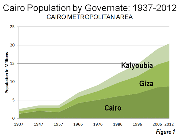
    Overall, the governates that comprise the Cairo metropolitan area have a population of approximately 20.5 million, according to a CAPMAS 2012 estimate. This is approximately the same size of metropolitan areas such as New York and Mexico City. The Cairo metropolitan area is comprised of three governates, which are principally urban, but which also contain millions living in rural areas:

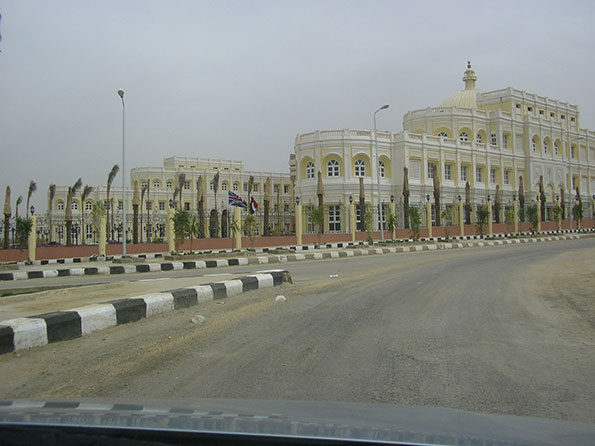
    The governate of Cairo (Al Qāhirah) is the largest of these jurisdictions. Parts of the Cairo governate and the Giza government would be considered in the urban core, but the political jurisdictions in Cairo do not lend themselves well to conventional core versus suburban designations (Note 1). The Cairo governate is located on the east bank of the Nile River, and spreads many kilometers, especially to the East and South. This area includes the Cairo international airport and Heliopolis, one of the most affluent areas in the Cairo metropolitan area. The governate of Cairo also includes "New Cairo," an attractive new town located in the southeastern quadrant. This area includes a number of university campuses, multi-story condominium buildings and detached housing. Eventually, New Cairo is expected to have 4,000,000 residents, though the new town is little more than a decade old and still has a modest population of approximately 125,000.


    New Cairo: University

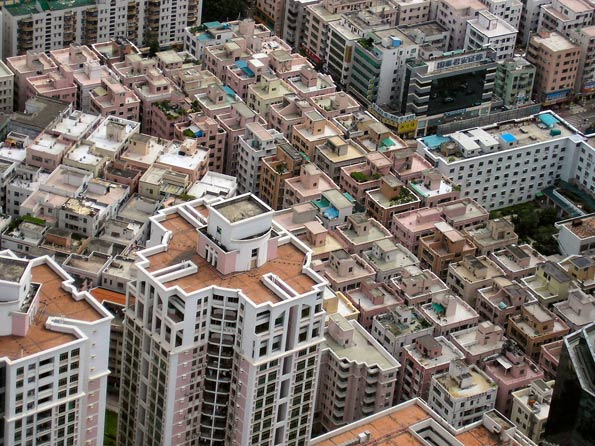
    The governate of Giza (Al Jīzah) is located on the west bank of the Nile River and, in reality, constitutes a continuation of the urban core. Giza is home the Great Pyramids, which rise on a hill from the western urban fringe. Giza is also home to considerable informal housing development   much different than generally found in other megacities. Much of the development is high rise, with concrete block buildings rising seven and more stories from the streets. Generally, the streets are so narrow and irregular that they are not shown on local maps. The governate of Giza also includes the "6th of October" new town, located on the west side of the hills on which the Great Pyramids stand. Eventually, 6th of October is expected to have a population of 3,000,000, though it appears to be less than 500,000 today. The governate of Giza also includes the Sheihk Zayed new town. These new towns have commercial activities, multi-story condominiums and detached housing.


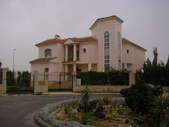
    Sheikh Zayed: Detached Housing


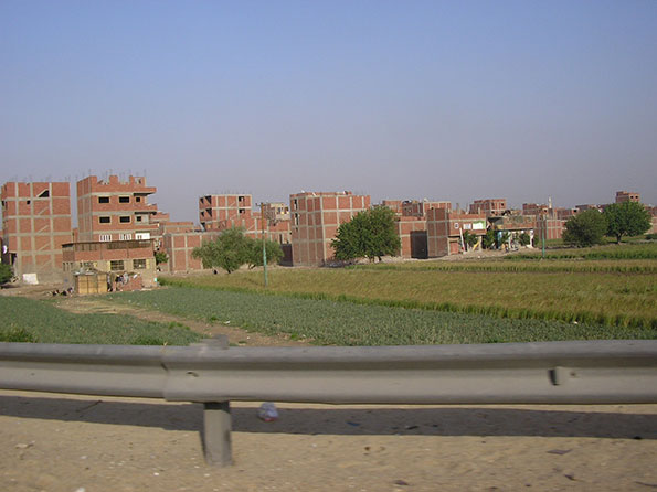
    Giza: Informal Housing

    The governate of Kalyoubia (Al Qalyūbīyah) is located to the north of the Cairo and Giza governates. Unlike Cairo and Giza, Kalyoubia has a majority of its population living in rural areas. However, the continuous urbanization of Cairo stretches into the governate and includes more than 1.5 million people, much of it in the municipality of Shubrā al-Khaymah.

    Slowing Growth: Like many of the developing world’s megacities, Cairo has experienced its strongest growth in the half century after World War II. In 1937, the metropolitan area had a population of under 3 million. This more than doubled to 7 million by 1966, and again to 14 million by 1996.  From 1996 to 2012, the metropolitan area added 5.5 million people (Note 2). However, more recently, the growth rate has slowed considerably. Between 1996 and 2006, metropolitan Cairo added 28 percent to its population (an increase of more than 4,000,000). However the 2006 to 2012 rate would indicate that by 2016, Cairo is likely to add only 13 percent to its population (approximately 2,000,000 people).

    While the governates of the Cairo metropolitan area do not lend themselves well to urban versus suburban population analysis, Cairo clearly has expanded geographically as it has added population. The more central governates of Cairo and Giza have continued to grow, however much of the growth has been in peripheral areas, such as New Cairo, 6th of October and the Helwan area, south of Cairo on the Nile (in the Cairo governate).

    Where the Growth is Occurring: Even so, the governate of Cairo accounted for only 19 percent of the metropolitan area’s growth from 2006 to 2012, down from 34 percent in the 1996 to 2006 period. The governate of Giza had the greatest growth between 2006 and 2012, at 47 percent of metropolitan growth, an increase from the 39 percent of 1996 to 2016. The governate of Kalyoubia accounted for 34 percent of the growth from 2006 to 2012, an increase from 26 percent between 1996 and 2016 (Figure 1).

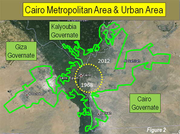
    Cairo’s Physical Expansion: Even though the suburban versus core analysis is difficult to gauge from governate data, a paper by Mootaz Farid and Hatam Al Shafie of Cairo University contains depictions of the urban footprint from 1943 to 1982. In each of the depicted years, the continuous urbanization of Cairo covers only a miniscule share of the present urban footprint. Figure 2 provides an estimate of the urban footprint in 1968 compared to the 2012 urban footprint, indicating that much of the growth was on the periphery.

    The Key to Decentralization: The key to making the new towns successful in attracting more residents lies with the dispersion of employment. There is a wealth of international experience to indicate that "self-sufficient" new towns really cannot be self sufficient if they are within commuting distance of the rest of the urban area. In the case of Cairo (as elsewhere) it will prove critical to ensure that there are substantial local employment opportunities for new town residents, although it is likely that a serious degree of self sufficiency may prove difficult to achieve.

    Wendell Cox is a Visiting Professor, Conservatoire National des Arts et Metiers, Paris and the author of “War on the Dream: How Anti-Sprawl Policy Threatens the Quality of Life.”

    Top Photograph: The Great Pyramid (Giza). All photos by author

    ——

    Note 1: In the past decade there  have been reorganizations of governates in the Cairo metropolitan area. This article uses three present governates for all years.

    Note 2: Earlier population data is from http://statoids.com/ueg.html.

  • Vermont: The Cost of Joining the Gentry Class

    There’s nothing particularly modern about traditional rural gentrification. The English roots of successful upper-middle-class urbanites retiring to newly acquired country estates with large houses and small livestock flocks are 18th century or older. Perhaps its earliest American example is Alexander Hamilton’s flight from below-Wall-Street-New York City to the Haarlem that was then the farm country of northern Manhattan Island. There, with wealth accumulated from professional career and governmental service, in 1802 he bought 32 acres of tiny Dutch farms and built his McMansion, “The Grange”, on a viewshed-surrounded hilltop where he could maintain (or not) connections with power and commerce a half-day’s coach travel to the south.

    Modern rural gentrification differs somewhat from its academic definition, in that it is not exclusively enabled by the power of a passive-income economic base. It is, though, at least in the theoretical model of most of those who now practice it, a near-Jeffersonian mix of productive and profitable small-scale farming coupled with a remunerative non-farm occupation most typically in the information sector or the consulting professions, commuting to work electronically from a home office or physically on a convenience and client-driven schedule.

    And there’s nothing particularly modern about gentrification’s economic clout. In both its urban and rural models, it is enabled by the newcomers’ advantages in wealth and skills, whereby they can readily afford to out-bid the locals for property and can equally readily cope with whatever regulatory barriers might be erected against their unwelcome (particularly in urban re-gentrification of down-scale neighborhoods) incursions. Particularly in recent academic (and sometimes polemical) studies of supposed violations of economic and social justice, much has been made of the new-comers’ ability and readiness to price the old-timers out of their former neighborhoods, although never (to Humble Scribe’s knowledge, anyway) have there been accusations that take-overs of Georgetown, DC: Roxbury, Boston: Brooklyn Heights, NYC; or Darien Street, Philadelphia, intentionally raised the overall local “cost-of-stay” so as to, in the phrase used against realtors during the white-flight episodes of the ‘60’s, “use high-bid block-busting to stimulate old-timer departure”.

    In contrast, there’s at least some evidence that the recent rural gentrification pattern in Vermont is partially connected with broad-based efforts to use a policy-based raising of the state-wide cost-of-stay in pursuit of a desired state-wide (limited and controlled) low-density and esthetically-nostalgic development pattern. The Vermont anomaly, if you will, is more than just the readiness of mostly-urban newcomers to buy into a rural/small-town state, their advantage based on above-average levels of wealth, past achievement, political skills, and business acumen. The pre-existing Green Mountain State taxation, regulatory, and general business climate, as shown in numerous state rankings and analyses, is exactly the motivating set of governmental and grass-roots forces typically responsible for the out-migration of just such folks from (perhaps more normal) states like California, Illinois, Maryland, or New Jersey. In those places, the same factors that are a draw in Vermont have been causally linked to just the opposite phenomenon: upper-middle-class exodus patterns.

    Historically, in-migration of just such urbanites and suburbanites to a once-truly-rural Vermont goes back to the arrival, in the late Victorian decades, of railroad magnates like Billings (to Woodstock) and Webb (to Shelburne), but is more typically illustrated by a later generation, exemplified by the Depression-era “back-to-the-land” migration of Helen and Scott Nearing from the high-rise apartments of NYC to a small farm in Jamaica, Vermont, where they grew some green beans and wrote books about “living off the land” when not on the lecture circuit. The publishing royalties for such as “Living the Good Life,” 1954, were their major but unpublicized source of active income, and, as was unrevealed until a post-mortem biography, multi-million-dollar (in today’s currency) trust funds held by both were the major source of real passive income.

    The wave of back-to-the-land immigrants changed Vermont’s demographics and politics irreversibly in the decades from 1960 on, changing a then-predominantly-rural/farm population of some 360,000 with near-zero natural increase to a predominantly-urban/jobs population of some 620,000, most having chosen to migrate in from the cities and suburbs of the East Coast megapoli to practice their own best approximations of the Nearing mix of small-scale ag, commercial enterprise, and trust-fund-check-in-the-mailbox economics ever since. Despite the pretense at making a living from the land, in economic reality the critical cash flow is pension or trust-fund-based.

    That quibble notwithstanding, the socio-economics of rural gentrification haven’t changed significantly (except for average age) since the first communes and hippie-yuppie colonies sprang up across Vermont in the ‘60s. Then, their members were typically college kids taking a few years off between the undergrad and grad-school years to grow veggies organically and supposedly meet cash expenses by selling them in ad hoc farmers’ markets to locals who were already quite self-sufficient, thank you, as well as to dabble in non-farm activities ranging from sex to politics. By any sociological measure, these young adults were both wealthier (family, mostly) and more educated than the rural natives they came to live amongst. Today, the new rural gentrifiers are older but similarly well situated.

    Those now selecting attractive rural counties and small towns where they can settle into the Nearing model choose places like Vermont, or like Virginia’s Shenandoah Valley, both attractively small enough (in the 9000 square mile range) to enable some degree of political control. If there’s a difference between Vermont and the others, it’s only that the 34000 square miles of Virginia, say, wouldn’t tolerate a state-wide raise-the-cost-of-stay as a keep-it-bucolic-and-nostalgic strategy. The Vermont incomers, having ascended to political power in a much smaller state, have indeed put in a range of policies — some covert, like raising housing costs while depressing business prospects via regulatory opacity, and some overt, like the present campaign to reduce power supplies by a third by shutting down the state’s only nuclear power generator — aimed at dissuading “growth” in favor of sustainability. A half-century earlier, Middlebury College environmentalist/advocate Douglas Burden explained it in terms of keeping the prices of residency high enough to dissuade middle-class residency, while using land use controls and similar devices to insure “keeping Vermont unattractive to additional people.” Those willing and able to pay the heightened cost-of-stay — the Vermont anomaly — would then enjoy their rarified bucolic/ nostalgic surroundings, as Charles, Murray writes, “…in a neighborhood filled with people as rich and smart as possible” much like themselves.

    There’s one other aspect of the Vermont anomaly worth noting. Neither those in state government, having watched the advance of rural gentrification and now beginning to claim credit for it and offer various “project funding” vote-purchase devices, nor those actually practicing their own modified versions of “Five Acres and Independence” (the perennial USDA best-seller text for rural-gentry wannabe aspirants for over a century) have addressed the basic conceptual conflict between two ideologies dear to up-scale exurban hearts and minds.

    One is “smart-growth”, which requires a small-house/small-lot in-town, walk-to-shopping trolley-to-work urban development pattern (think Portland OR), with no housing beyond the last water and sewer lines. The other is, of course, rural gentrification, which requires at least a few acres in the countryside to grow and sell veggies while using the home office to conduct electronic non-farm profitable business that actually pays for the family’s health care and the kids’ college as arugula and cilantro almost never can. It takes a certain amount of cognitive-dissonance skill to embrace both ideologies simultaneously, but, interestingly, most of the new rural gentry are up to that intellectual task. In simplified form, rural gentrification — the farmette in the country — is for them and their similarly-situated peers and neighbors; “smart-growth” is for everyone else, dissuading those of lesser standing who might otherwise actually presume to come in alongside them to raise their own few acres of apples (and generate crop-shipping truck noises which necessitated a Vermont Supreme Court challenge) and thereby spoil not only the early morning silence but the no-visible-farm-machinery viewshed. But, when smart-growth and rural gentrification finally meet on the field of political and legal combat, practitioners of the latter will be up to the challenge. George Mason Law School professor F. H. Buckley explains why and how:

    “Burdensome tax and regulatory policies will be of relative advantage to the rich and powerful, who can employ specialists to work through the maze of rules that impose traps for unwary members of the middle class.” And he doesn’t even touch on Vermont’s own preferred-ten-acre-lot recent (post-‘60s and pre-smart-growth) history, the rural development policy of choice until a new ideology came along. That’s a whole ‘nother Vermont anomaly calling for a whole ‘nother commentary.

    Flickr photo: Chard in the Montpelier, Vermont State House Garden, by Waldo Jaquith.

    Martin Harris is a Princeton graduate in architecture and urban planning with a range of experience in fields ranging from urban renewal and air-industrial parks to the trajectory of small-town planning and zoning in states like Vermont.

  • Midcentury Modern

    Midcentury modern tours now are taking place in cities all over the country. Renewed interest in this era capitalizes on the millennials’ interest in design from a time that seems almost impossibly optimistic compared to today’s zeitgeist. Most cities around the country boast a healthy building stock from this postwar period, nicknamed “the suburbs,” although these are ritually condemned – and designated for annihilation – by academics, urban land speculators and the urban clerisy.

    Yet the new interest in the mid-century modern form reflects its basic and enduring appeal. As the curious and the trendy take bus tours of these inner-ring neighborhoods, the forms of this era evoke a sense of great confidence and faith in the future, both of which seem to be lost in the obsession with neo-traditional forms that hearken to the pre-car era or to the cartoonlike, sculpture-as-architecture one sees in many urban centers.

    Suburban expansion after World War II reached out beyond the streetcar systems that created the traditional neighborhoods of the late 19thand early 20th Century. The returning GIs wanted something simple and affordable to begin their lives after serving their country. Confidence surged in America’s know-how and ability to solve even the deepest social problems. The triumph of science and technology was a palpable presence. The dark side, of course, was the atomic threat, restraining our enthusiasm but only a little.

    In this midcentury era, planning and design began to be car-based. Residences were designed to show off the car, putting it out front for display – and some home plans even had tailfinned beauties in the living room


    Living Garage, photo from Populuxe by Thomas Hine

    Consumer goods were no longer accessed on foot; a new form of luxury consisted of driving up to the front door of a shop with parking in front. Front-loading houses and stores became unquestionably more efficient as a means to accommodate the new American lifestyle.

    Yet despite the auto-orientation, the architecture of this era retained the pedestrian scale and intimate feel that marked Main Street before World War 2. This both/and aesthetic marks the form of the 1940s and 1950s, with streamlined design styles like Art Deco Revival and materials like glass and stainless steel. Gentle angles suggested motion, and the theme of mobility was everywhere in the architecture.  Wider streets and lower, longer horizontal lines accommodated this theme and even today the architecture reinforces a feel of motion when driving past these structures.

    Modernism also formed a certain ethic. To be modern was more than a lifestyle choice; it was an acceptance of science, knowledge, and technology, free from preconceptions.  At the time, modernism elevated architecture above the style debate, and was considered even a shedding of styles. The politics of the time was similarly marked by Truman’s “straight talk”, and there was a shedding of rhetoric and posturing that lasted up until Joe McCarthy began once again a divide-and-conquer campaign against people.

    Translated to the suburbs, modernism meant practical homes, without the adornment that marked Victorian architecture. Instead, modernist residences were marked by deep horizontals and large picture windows, providing a sense of openness that was a hallmark of modernist thought. Floor plans also were open, allowing free movement through space, rather than cutting the house up into cluttered little parlors, dining rooms, or nooks. 

    Today, midcentury modern design is fetishized for mass consumption in magazines like Dwell that emphasize acquisitiveness over ethics. But back then, the design meant something else, something cleaner and more powerful. In the 1950s, modernism meant consumption, but even more, the modernism defined the quest for the inner self and a new, forward looking outlook.

    By reducing modernism to a sofa style or wallpaper pattern, we risk losing all that this era stood for.  Buildings from the 1950s have sustained themselves through multiple recessions, the rise of the internet, cultural acceleration, massive city growth, and globalism. So perhaps they point towards a real definition of sustainability by having good bones and adapting through all these changes.

    The current millennial generation seeks a practical domestic situation, much like returning GIs. Most would prefer to reduce car-trips, but are realistic about this goal, given the range of their travel. Most in this generation see right through car-free living claims; more than one of my students, when discussing walkability, stated that “I’m not gonna lug my groceries even a block in this heat.” The battle with the car is chiefly about making the car more efficient, and less ubiquitous through the use of telecommuting and on-line shopping. It is not about removing it from the scene entirely.

    So as McMansions have swollen to represent a kind of architectural obesity, they have made many midcentury neighborhoods unfashionable, for typically these older homes have one parking space, often in a carport, not a true garage. They also are front-loaded, a much more efficient planning concept than alleys, but then the car becomes part of the front façade. Millennials have a hard time understanding what’s wrong with that. Again, as one 28-year-old student put it to me, “It’s just a house, after all…what’s the big deal?”

    Developers seeking first-time homebuyers, however, respond to the regulatory climate, which favors solutions like garages on alleys, big homes on tight lots, and neotraditional styling.  Bonus density and other zoning incentives rig the game in favor of this highly regulated development pattern, even in the exurbs.  Here in Central Florida, the development zone nicknamed Horizon West has been codified to enforce these form-based principles, with stiff permitting fees and a highly participatory government staff to keep things on the straight-and-narrow.

    Keeping prices low with all this overburden requires developers to cut the cost of the home drastically, likely reducing lifespan of components and systems. Ironically, the house meeting these tortured standards of today is less sustainable than the house built in 1953, with better bones and an adaptable floor plan.

    Meanwhile, these 1950s neighborhoods are under attack for their very form. Cities, persuaded by planners to heal the effects of the car, cannot do so in a granular manner, so ordinances are passed  forbidding front-facing garages, or garages set back arbitrarily from the house front. These 1950s homes, with their carports, couldn’t be built today, and so are reduced to the status of heritage sites from a bygone era. In Winter Park, garages are banished to the rear on new homes, and if you are adding a garage to your midcentury home, it must be arbitrarily set back at least four feet from your front wall whether or not your lot can accommodate this arbitrary, and seemingly pointless, ordinance.

    Of course mid modern tours allow people to rediscover the essence of the 1950s, and these overlooked neighborhoods could be the springboard for a new era in modern planning.  Front-loaded neighborhoods can be successful when the architecture is designed at a human scale, and fine-grained integration of residential and commercial uses point to a future of home-office, cottage-industry, people-based industry once again.

    The Victorian era ended rather abruptly in the 1890s with a series of economic catastrophes that changed America’s middle class. Architecture switched to a more streamlined, Edwardian style – simple, flexible, and utilitarian forms that quickly gave rise to modernist design.  This current economic transition may well bode a similar outcome – design styles, often labeled “contemporary,” reduce the amount of architectural gingerbread and fussiness, reducing cost and maintenance, and may be favored by the coming generation for its cleanliness and utility.

    A new era that manages the car at a human scale, forgives people for wanting mobility and efficiency, and allows for contemporary exploration of style and design can and should inform new neighborhood planning. Midcentury suburbs, rediscovered by popular interest, can point the way to a middle ground between mcmansion-style subdivisions and neotraditional fussiness, and maybe even help us rediscover our confidence and faith once again.

    This essay is a summary of Richard Reep’s talk “Populuxe and the Atomic Bungalow” given at the 3rd annual Colloquium on Historic Preservation, hosted by Friends of Casa Feliz, Winter Park, Florida in April 2012.  Richard and his wife, Kim Mathis, hosted a midcentury modern tour in their own 1950s home for the colloquium.

  • The Evolving Urban Form: Shenzhen

    No urban area in history has become so large so quickly than Shenzhen (Note 1). A little more than a fishing village in 1979, by the 2010 census Shenzhen registered 10.4 million inhabitants. It is easily the youngest urban area to have become one of the world’s 26 megacities (Figure 1). Most other megacities were the largest urban areas in their nations for centuries (such as London and Paris) and a few for more than a millennium (such as Istanbul and Beijing). Shenzhen’s primitiveness can be seen in this 1980 internet photo, and shows the beginnings of construction. A 2006 photograph of one of Shenzhen’s principal streets (Binhe Avenue) is above.

    Pearl River Delta Location: Shenzhen is located in Guangdong Province adjacent to Hong Kong’s northern border. Shenzhen is China’s fourth largest urban area, following Shanghai, Beijing, and Guangzou-Foshan.

    Along with Dongguan, Guanzhou, Foshan and smaller neighbors, Shenzhen forms the Pearl River Delta,   the world’s largest manufacturing center. The Pearl River Delta, along with Hong Kong and Macau, constitutes the world’s largest populated extent of urbanization, with nearly 50 million people. They live in a land area of just over 3,000 square kilometers (7,800 square kilometers. By comparison the world’s largest urban area, Tokyo-Yokohama, has a population of 37 million and covers 3,300 square miles (8,500 square kilometers). I recall from a Hong Kong to Guangzhou trip on the Canton-Kowloon Railway in 1999 that there was plenty of rural territory on the 100 mile (170 kilometers) route. Today,   development takes place along virtually the entire route (Note 2).

    The Special Economic Zone: Shenzhen was established as China’s first special economic zone by Deng Xiaoping in the period of liberalization after the death of Mao Zedong. The special economic zones allowed for alternative, generally market oriented reforms, with the end of improving economic growth. The result was economic progress far greater than anyone expected. The special economic zone program was eventually extended to several other urban areas in the nation.

    Some governmental officials preferred the previous state dominated approach, despite its greater poverty and sought to roll back the reforms. This threat reached its peak in the early 1990s, after Deng Xiaoping had retired from his government positions. In response, Deng undertook his renown "southern tour" to Shenzhen, Guangzhou and other parts of Guangdong province to promote the new economic approach and the progress that had been made. During the southern tour, Deng is reputed to have said that "to be rich is glorious." Three decades before he had said “I don’t care if it’s a white cat or a black cat. It’s a good cat as long as it catches mice." He committed to results rather than to ideology, in a sense Shenzen and its environs are the engines of non-state owned prosperity. Eventually, the publicity from Deng’s southern tour overwhelmed the opposition and China accelerated its move toward a more open economy.

    Shenzhen’s Core: Unlike the fast growing, but much smaller new urban areas of the United States (for example Phoenix, which is largely a low rise, dispersed expanse of suburbanization), Shenzhen has developed a dense central business district. Even though Shenzhen started the decade of the 1990s with little more than 1,000,000 residents, by 1996 it had the fourth tallest building in the world, the Shun Hing Tower. Only the Sears Tower in Chicago and the two World Trade Center Towers in New York were taller.

    In 2011, the Shun Hing Tower lost its local tallest building title to the Kingkey Financial Tower, at 1,449 feet (447 meters) is the 10th tallest building in the world. Now, the world’s second tallest building is under construction in Shenzhen, the Ping An International Financial Center, which is reported to reach 2,125 feet or 655 meters, with 116 floors. Only the Burj Khalifa (2,717 feet, 828 meters, 163 floors) in Dubai would be higher. Like Shanghai and Chongqing (and unlike most Chinese urban areas), Shenzhen has a highly concentrated central business district. As a result deserio.com rates Shenzhen’s skyline as 9th in the world (Note 3).

    Outer Areas Growing Faster: The three central districts (the qu of Futian, Luohu and Nanshan) grew from 2.4 million to 3.3 million population between 2000 and 2010, a rate of 38 percent. However, as is natural for a growing urban area, most of the growth was in the outer districts (Photo: Suburban Shenzhen), which grew from 4.6 million to 7.0 million, a growth rate of 52 percent. Thus, nearly three-quarters of the growth was on the periphery (Figure 2). Population growth in the earlier 1990 and 2000 period was slightly less concentrated in the outer area (68 percent). But overall  population growth has begun to slow down, with Shenzhen added 3.3 million new residents, compared to 4.3 million between 1990 and 2000.  


    Photo: Suburban Shenzhen (Longgang)

    The Urban Area: Overall, it is estimated that the Shenzhen urban area (area of continuous development) has a 2012 population of 11.9 million, with a land area of 675 square miles (1,745 square kilometers). The urban area has now crossed the border into the Huiyang district of the Huizhou region, to the east. The population density is estimated at 17,600 per square mile, or 6,800 per square kilometer,  approximately 10 percent less dense than the average urban area in China. Shenzhen is about one quarter the density of Hong Kong and double the density of Paris.

    Rich and Poor in Shenzhen: Like all urban areas, Shenzhen is a mixture of rich and poor. Shenzhen is generally considered one of the most affluent urban areas in China, yet it also has a very large low income population. Approximately one-sixth of China’s residents are considered to be temporary migrants; many work in boomtowns like Shenzhen. Seven million of these 220 million migrants live in Shenzhen,  considered the largest migrant population of any region in the nation. Migrants are attracted to Shenzhen for the same reasons people have moved to cities from early on: to get ahead. At the same time, their remittances sent back home are contributing to improved living conditions far beyond Shenzhen. It is expected that reforms to the "hukou" system of residence permits will allow many of the temporary migrants in Shenzhen and elsewhere obtain permanent residence status. Many of the migrants live in factory housing, or older, very densely packed buildings. At the same time, Shenzhen has a large number of world-class condominium buildings.


    Photo: Older Housing: Central Business District


    Photo: Newer Housing: Central Business District

    The Future of Shenzhen: Much of Shenzhen’s future will depend upon the economy of the Pearl River Delta and the extent to which migrants are able to obtain permanent residency status. There is still land enough in the region for substantial population growth. The longer term integration of the Hong Kong and Shenzhen economies could produce an even larger economic dynamo than the two that are currently separate. One thing is certain, however. Shenzhen has led China into a new economic and urban reality.

    Wendell Cox is a Visiting Professor, Conservatoire National des Arts et Metiers, Paris and the author of “War on the Dream: How Anti-Sprawl Policy Threatens the Quality of Life”.

    —–

    Note 1: Shenzhen is one of China’s regions, often called "cities," as translated from "shi."  "Shi" more resemble regions than "cities" in the non-Chinese sense, this article refers to "shi" as regions. "Shi" were formerly referred to in English as prefectures. A province is usually composed of "shis" and other "shi" level jurisdictions.

    Note 2: These combined regions are not a metropolitan area, for two reasons. First; there is little daily commuting between them and thus they are not a single labor market, which is the definition of a metropolitan area. Second, one of the regions, Hong Kong, has a border with Shenzhen that has international style customs and immigrant controls, which further precludes the two adjacent regions from being a single metropolitan area. In the longer run, greater affluence, greater mobility between the regions and relaxation of border controls could merge some or all of the now separate metropolitan areas.

    Note 3: Desiro.com, unlike some other skyline rating systems, places a premium on the density of buildings, rather than simply amalgamating building heights from throughout an urban area.

    Photo: Shenzhen:  Binhe Avenue from the Shun Hing Tower (by author)

  • 84% of 18-to-34-Year-Olds Want To Own Homes

    A survey by TD Bank indicates that 84 percent of people 18 to 34 years old intend to buy homes in the future. This runs counter to thinking that has been expressed by some, indicating that renting would become more popular in the future. Much of the "home ownership is dead or dying” comes from short sighted trend analysis in which home ownership data begins with the start of the housing bubble in the late 1990s. The latest data from the Bureau of the Census indicates that the home ownership rate in the first quarter was 65.4 percent, the lowest rate since 1997. In fact, however, before the housing bubble, homeownership hovered generally at 65 percent or below, after having increased strongly from 44 percent in 1940 to 61 percent in 1960. The increase in homeownership during the bubble was the result of profligate lending policies that were not sustainable. The decline from the artificially high housing bubble peak in no way diminishes the successful expansion of homeownership in the nation during the decades that reason prevailed in home lending.

  • CNU20: New Urbanism’s Young Adult Angst

    Possibly the most earnest folks in the real estate development industry assembled for the 20th anniversary of the founding of the Congress of the New Urbanism in West Palm Beach, Florida this month. Among the excellent accomplishments of CNU20 attendees: a credible car/pedestrian strategy, some fine looking new communities, and perhaps best of all, a body of hard-won knowledge about town-making for citizen education.

    Officially, CNU20 was optimistic and confident, but an undercurrent of negativism marred the event. More than one New Urbanist questioned the validity of what by now should have been a transformative movement. But the imposition of form-based codes and regulations on city growth has become a stress point in the movement’s evolution.

    Three hundred communities now boast New Urbanist town planning, over a dozen communities have adopted form-based zoning, and urban design schools are teaching the New Urban principles all over the country, facts triumphed during the opening plenary session. Form-based zoning uses a hierarchy of increasingly dense districts with defined boundaries, rather than land-use (or Euclidian) zoning to regulate growth. These principles are exquisitely defined in a model code nicknamed the Smart Code, which defines street width and sidewalk width, and provides fine-grained guidance on the form of a building on a given lot. Participants in early work sessions were taught how to work the code, and walked the hot, humid streets of West Palm Beach to interpret its many nuances and subtleties.

    In 2003, Downtown West Palm Beach was redeveloped, and it should be a proud example of the earliest New Urban efforts. Instead, conference participants spoke of the result with open distaste. The main outdoor plaza features a noisy fountain, which a group of attorneys, architects, and land planners belittled as “a mini Bellagio”; a pale imitation of the huge Las Vegas hotel’s water feature. Andrés Duany, one of the founders of the CNU, stated during the conference that “much of the architecture of the downtown zone was junk.” The movement’s most flamboyant spokesman, James Howard Kunstler, cited the “cartoonish, low quality finish of the buildings” as a failure. The distance New Urbanists have put between themselves and one of their finest achievements is dismaying.

    When not complaining about West Palm Beach, many practitioners wandered the somewhat sparse exhibit hall of booths sponsored by municipalities, attorneys, and consultants. Conversations often hit notes of personal suffering. Few new communities of any scale are being funded, so just as the supply of highly trained New Urbanists has hit the market, demand has dwindled to a trickle of infill projects here and there. Morale at the ground level was quite low, given the effort New Urbanists have put forth.

    Pedestrian-based urban form is a science that New Urbanists can offer to every community, and it has been a win for them where it has been implemented. Our monocultural vehicular transport model of car-dominated cities has made people work hard to carve out social space. The New Urbanist critique of the aesthetics of transportation is right on target. Armed with plenty of real data about how pedestrian environments work, New Urbanists have succeeded at softening the city and allowing pedestrians to compete.

    New Urbanists can also point to successes in the real estate market. In one study session, three single-family residential New Urbanist communities were analyzed, and the developer’s financial models were revealed. Each of the three communities fared better than their competitive set through the 2008-2012 cycle, in terms of net present value, appraisals, and foreclosure rate. New Urbanists claimed credit for this, although the affluent demographics and in-town locations tilted the plate in their favor. Still, New Urbanists have created a strong model that works for a segment of the population.

    Perhaps New Urbanism’s most potent contributions are to the art and science of traditional town planning. A solid body of knowledge that is based upon beautiful real places— Charleston, South Carolina and Savannah, Georgia, to name just two — now informs much of the theory behind place-making. We Americans are notably unsentimental about our cities, tearing down landmarks and whole districts in the quest for efficiency and betterment. New Urbanists have made it fashionable once again to care about history and good design, and our cities are the better for it.

    The CNU’s 20th anniversary marks a curious point in the life of this laudable and lasting movement. Because there isn’t any new development occurring, government effortshave turned towards adding form-based code overlays to existing cities. Already, Miami and Philadelphia have passed these codes to regulate growth. Many other cities like Orlando operate a standard zoning code by ordinance, while enforcing a form-based code as well. Property owners, developers, and design teams must now satisfy the intricacies of two local codes, rather than one, to get a building permit.

    While de-regulation is a term on everyone’s lips, this quiet up-tick in regulation has occurred largely under the radar screen. Those pushing for form-based code are largely consultants, who argue that the code will make for a better city by protecting us from ourselves. Municipal officials are amenable to, it, too.Both groups see the job security it promises them. Developers see profit if their communities can boast adherence to a strict code that promises a better lifestyle.

    Developers would normally scream loudly at any new regulation, no matter how trivial, but they are passively allowing form-based code because of the effect it can have on their bottom lines.
    If these codes tend to increase cost, well, the financial investors don’t complain, because the more money that’s borrowed to complete these structures, the more interest income they earn. So — form-based codes benefit all the interest groups that advocate their implementation.

    At CNU20 we witnessed the coming of age of a new regulatory regime. Place-making, once an activity trusted to individual citizens, has become codified; a vision enforced by authorities and interpreted by high priests who have special training to understand how to make a proper city. Maybe we have so abused our power as individuals that we deserve to have this power taken away. Perhaps our city form is so ugly, and so dysfunctional, that we cannot rescue it without serious intervention.

    Or, perhaps not. The American Dream is not about freedom from sprawl, as suggested in the movement’s seminal manifesto, “Suburban Nation”. Rather, it’s about freedom to choose. New Urbanists might be able to provide this freedom within the confines of a new institution, the Smart Code, as long as the Smart Code produced good results. But if the critique at CNU20 of their own Downtown West Palm Beach is any indication, the Smart Code ain’t so smart after all.

    American town planning needs less regulation, not more. Let’s use CNU’s body of knowledge to educate citizens and provide a path forward, not with the manacles of a new code, but with the freedom to create a new urban form that suits the lifestyles of the 21st century.

    Flickr photo by Eric Alix Rogers, New Urban, in Six Corners, Chicago. New houses, all facing a common sidewalk, with garages on alleys behind. Off of Kilbourn, just south of Irving Park.

    Richard Reep is an architect and artist who lives in Winter Park, Florida. His practice has centered around hospitality-driven mixed use, and he has contributed in various capacities to urban mixed-use projects, both nationally and internationally, for the last 25 years.

  • A Free Range Life

    Some may have never heard of the term exurbia before now. According to the free on-line dictionary it means: The exurbs collectively; the region beyond the suburbs.

    Exurbia to me is an expression that defines a free range lifestyle. Where I live there is space, nature surrounds my house, I can play music as loudly as I care to, trails connect me to beautiful places, when a recipe calls for lemons or rosemary, I can walk outside and collect whatever I need, and a seasonal garden provides all the abundance I require to make healthy and organic meals.

    Getting around town is easy and I usually find everything I need in one trip. I used to live in an urban area and now feel grateful that I don’t have to cope with the inconveniences of that lifestyle any more. More on that later!

    It takes about 20 minutes for my husband to commute to work every day. When the day is over and he comes home, he looks forward to propping up his legs, reading and smoking a cigar. We have neighbors and we like waving to them from across the way. Recently, we have been getting together to make wine.

    We did not always have the privilege to live in this atmosphere of peaceful, quiet living. When we lived in the city, we were constantly fighting for parking spaces, we had to traipse up and down stairs to do laundry and then dry clothes on a line outside and risk icicles on the sleeves of our shirts and the bottom of our pants.  The traffic was exhausting and the noise from the neighbors below us, behind us, and on top of us was annoying and distracting. Raising kids in this environment was tedious and kept us constantly vigilant.

    The day we finally moved into our house in the exurbs was a great day! Unfortunately, our dream of retiring in this home, developing the orchard and the garden, and enjoying our new quality of life, may be directly impacted by a new trend in planning called sustainable development and smart growth.

    As I research these new planning trends I have learned that what this force of change really means is a whole life plan. Sustainable development seeks to change the way we live, how we interact with nature, how we choose to use our land and our property (all property–even your own person!!), where we live and how we live! It is a massive propaganda piece to change our behavior and how we think.

    We must educate ourselves about the truth behind the ‘green’ agenda, the urban consolidation agenda, the livability agenda, and any and all agendas having to do with sustainable development.

    In order to recognize this whole life plan when you see it, you must understand the words they are using and the methods they are using to implement it. The planners, environmentalists, social activists, city, state and federal officials, media, and public relations firms are telling us what these plans are. We are not educated yet.

    I want to share my exurban quality of life.

    Check out Mary Baker’s new blog, Exurbia Chronicles.

  • Smart-Growth and Smarter Technology

    If you’re an enviro-regulator with a mission, preventing “sprawl” has been ideologically trendy in recent decades. You have successfully predicated your argument on past-history soils-management technological inadequacy, it must be enormously threatening to look back and realize that technology has been gaining on you and is now capable (in engineering terms) and affordable (in end-user cost terms) of enabling just the sorts of rural development the majority of the market-for-housing wants, but you’ve been trying so hard to prevent: Currier-and-Ives-tradition large-lot houses in the countryside.

    Case in point: the inadequate-soils argument long used by anti-rural-housing-and-business advocates to demand that buildings not be built anywhere soils aren’t naturally capable of environmentally-sound management of on-site sewage flows, and connection to a piped municipal sewer system isn’t feasible.

    One way to win the sewage-flow argument is to control the information flow so that targets of your engineering-inadequacy argument don’t get to know about technologies they might employ, passing all tests of environmental quality and product affordability, to build and occupy the house and-or business in the countryside they want and you don’t want them to have.

    If you’re good at it, you can keep the new technologies pretty much unknown to the public long after they’ve ceased being new. For example: chances are your local and regional planners and zoners never passed along to you the Winter 1996 issue of “Pipeline,” a quarterly effort of the National Small Flows Clearinghouse, a Federally-funded enterprise of the National Environmental Services Center within the U.S. Department of Agriculture and headquartered at West Virginia University. That issue was devoted almost entirely to a then-quite-innovative alternative to traditional septic-tank-and-disposal-field design: it was labeled “aerobic” to reflect its use of electric-powered air flows to enable oxygenated digestion, in contrast to the anaerobic design for traditional septic tanks.

    As the text explains, “aerobic…a good option…where soil quality…isn’t.” The Aerobic Wastewater Treatment module can be installed and used irrespective of natural site conditions. That was 26 years ago. Last month, the State of Maryland adopted legislation to advance “Smart-Growth” and prevent rural development by establishing new and more rigorous criteria for septic (anaerobic) tank installations. Not a word in the press releases about aerobic technology. Irony: your tax dollars pay for “Pipeline,”  which describes its objective as “small community wastewater issues explained to the public,” but in the last 26 years there’s been zero effort, on the part of your planners and zoners to assist in that effort. Have they actually worked to suppress such (in their opinion) non-useful information, possible counterpoints to their growth-control doctrines? You decide.

    It was (and still is) understandable that land with low-permeability clay soils, high water tables, shallow depth to bedrock, and similar negative qualities would be disqualified for in-ground septic systems on the grounds of predictable system failure. If non-soil-based systems didn’t exist, the logic of rural-development-prevention (no access to municipal piped systems) would prevail. That’s why Denver, back in the 80s, mounted a regional green-belt anti-sprawl campaign by curtailing municipal system expansion into previously-unserved real estate. It’s not understandable that development controls based on soil (in)capabilities should still be in place long after non-soils-based technologies have been engineered, manufactured, and marketed. Unless, of course, the soil-capability argument was an excuse, not a real reason.

    * * * * * *

    Before these little AWT packages became available (and have been unsuccessfully publicized by the Feds since the 90s) the industry was already interested in an even lower-tech non-soils-based design: the evapo-transpiration concept, where primary-treated effluent coming from a traditional septic tank is released into an under-sealed heavily-vegetated patch (in some designs, a shallow lagoon) where about two feet of vertical evaporation will take place annually if rain and snow are kept off. That’s a typical number for northern New England.

    Depending on location with respect to septic-tank discharge, electric power for pumping may or may not be needed. But industry interest was pretty much trumped by regulator hostility. Many fruitless meetings were held in Montpelier and Waterbury on the subject, even one at which copies of the 1980 Environmental Protection Agency Design Manual were handed around the table, to no avail.

    This raises the basic Smart-Growth question: can it be sold to (or forced on) a generally unwilling public only by pretending that the engineering basis for “sprawl” doesn’t work? There’s ample historical evidence –see Chapter 5, Ben Wattenberg’s “The First Measured Century”, for example—that “…the preference for the single-family detached house was even higher at the end of the 20th century than at the beginning…” but the top-down campaign against just such “sprawl” continues anyway.

    It doesn’t seem to matter that such exemplars of Smart-Growth as Portland, OR now show some of the highest housing costs in the nation; or that a new Cal State report on housing costs and young-adult out-migration speaks to a preference “…for raising children on backyards rather than condominium balconies.” One way to counter that, of course, would be to make the backyard even more expensive than the condo by pretending that the traditional on-site sewage system for the former is an engineering health hazard, and that no environmentally-acceptable customer-affordable alternates exist.

    To advance Smart-Growth it helps to keep the research and publications of the National Small Flows Clearinghouse as hidden as possible. There are some things, you understand, that the natives are better off not knowing, lest it make them restless.

    Martin Harris is a Princeton graduate in architecture and urban planning with a range of experience in fields ranging from urban renewal and air-industrial parks to the trajectory of small-town planning and zoning in States like Vermont.

    Rural Vermont home photo by Bigstockphoto.com.

  • London’s Social Cleansing

    Unscrupulous landlords are forcing poorer tenants out of their London homes, freeing them up to rent out to visitors to the Olympics this summer, according to the housing charity Shelter. At the same time, the government’s cap on rent subsidies (Housing Benefits) for those out of work or on low incomes threaten to force less well-off tenants out of the capital. Newham Mayor Sir Robin Wales says that they will have to move people as far afield as Stoke-on-Trent if they are to meet their obligations to house the homeless. Fears of ‘social cleansing’ featured in the Mayoral election where Tory incumbent Boris Johnson made sure to distance himself from his own government’s policy to beat off the challenge from veteran left-winger Ken Livingstone.


    Inner London, outer London (Newham in red); London, Stoke-on-Trent

    Critics of London’s ‘Social Cleansing’ have fixed on the changes to the law regarding housing benefits and the Olympics, but failed to notice that working class Londoners have been being forced out of the nation’s capital for some time now – thanks to the ceaseless rise in house prices. On the London Programme in 2003, I said that without opening up more land to building in the green belt, house prices would spiral out of control, pricing ordinary Londoners out of the capital. Mayor Ken Livingstone slapped me down saying that he would never sanction building on the green belt.

    Today Eva Wiseman, a commissioning editor on the upmarket broadsheet, the Observer, says that she cannot afford to rent in London’s once poorest borough, Tower Hamlets, let alone buy a house. She cites Shelter’s estimate that you would need an income of £67,669 to rent there (average income is £26,244).1

    It is not hard to understand why prices are so steep. Housebuilding in the UK has failed to keep pace with demand. New housing starts are slightly up after the crash, but overall they are woefully short of actual need. The reason is that Britain has among the most stringent laws on building – the ‘planning laws’ – which stop building on the ever-growing ‘green belts’ that surround our cities.

    Given that the working class are the Labour Party’s natural constituency, you might have thought that its years in government (1997-2010) would have seen more homes built for working people. But Labour turned its back on the working classes a long time ago, while keeping its neurotic interest in regulating the economy. The outcome was a re-vamped planning system that put the brakes on home building. This time this was done in the name of the environment, not to protect the Tory Shires from ‘bungaloid sprawl’, as it was originally intended. Housebuilding fell below the bare minimum of 250,000 you would need just to replace the increasingly dilapidated stock.

    When David Cameron’s Conservative-Liberal coalition came to power in 2010, his Communities Minister Eric Pickles and Housing Minister Grant Shapps had promised a large scale liberalisation of the planning laws – and even blamed their predecessors for doing more damage than the Luftwaffe to Britain’s housing stock. But the fine print on Shapps’ new planning law proved as prohibitive as what went before. Even those champions of the Green Belt at the Guardian were moved to editorialise that ‘these convoluted and qualified planning laws will become another aid to the big-money lawyers’. 2

    The Conservative government’s commitment to liberalisation is like its Labour predecessor’s commitment to the working class, theoretical. Home building remains stalled, and prices have not seriously fallen despite the shortage of credit). Governments of all stripes are most committed to orderly regulation of change, and dread the unsupervised activity of their citizens – a prejudice which has only led to chaos.

    The short supply/rising price dilemma is particularly intense in London. A metropolis of nine million creates a fierce competition for prime sites. Even putting aside the super-rich boroughs, like Kensington and Chelsea, where average prices are £1.3 million (roughly $2 million US), the overall London average is £406,000 ($770,000 US) .

    Besides being the most logical place for real estate speculation from around the world, London also has been in the grip of the planning system. It was in London that the Labour mayor took on architect Richard Rogers as an advisor, and committed the capital to a programme of building only on brownfield (already developed) land, ‘building up, not out’. The result is not much building at all, except to pack more four and five storey blocks into what few pockets of green space can be grabbed. His successor Boris Johnson has avoided challenging the Livingstone system, preferring a quiet life to any hint of controversy.

    Rather than face the problem of the absolute shortfall in new homes, most critics have fixated on peripheral issues, such as the number of empty homes (which, despite the attention they receive, are, because of high prices, at an all-time low). Easy credit, too, has been blamed for high prices, which is true, but the shortage of credit has not led to a great fall in prices, because the underlying problem was the absolute shortage of homes. Others have argued that the British are too wedded to the idea that they should own their own homes, and could rent, like the Germans, failing to understand that the availability of homes to rent depends on their being built, and rents tend to move in the same direction as prices, as The Observer’s Eva Wiseman has discovered. London’s Mayors have dedicated much attention to schemes to build ‘affordable homes’ – sometimes reserved for occupations like teachers and firefighters – though these are too few in number to have much impact on prices overall.

    Over time, this means working people are being priced out of central London. Tim Butler, Chris Hamnett and Mark Ramsden’s analysis of London’s employment in the 2001 census shows that outer London and the South East is more working class than inner London. Inner London had more large employers, professionals and managers than outer London and the South East. Outer London had more routine, semi-routine and technical or lower supervisory workers. Inner London did have more unemployed than outer London, and outer London had more self-employed than inner London. This employment profile was new, following changes that took place after fifteen years of economic growth, say Butler and his colleagues, though many have noted the sharper contrasts between wealthy enclaves and impoverished housing estates dogged by underemployment. 3

    These social changes show inner London’s parallel embourgeoisment and deepening social poverty. Of course, those who live in the outer suburbs scoff at the protests from well-heeled social commentators about the prices in inner London as ‘Zone Six snobbery’. Still the changes go some way to explaining why Ken Livingstone was unable to sustain the traditional City Hall machine he built consolidating constituencies among inner London’s poor immigrant and residual working class   communities while Tory Boris Johnson won  over the more working and middle class outer suburbs.

    In his last term Livingstone concentrated on winning over London’s bloated financial service sector more than he did on popular support – but the City of London switched its allegiances to the Tory Johnson, who champions it as an engine of growth. Neither candidate has understood that the skew towards the overheated financial service sector creates a weakness in the London economy, with manufacturing having moved out to the surrounding South East and a growing lack of upwardly mobile jobs for all but the most skilled or privileged.

    The housing benefit cap clearly is a problem for welfare-dependent families who are caught in the poverty trap and cannot earn enough to pay the rent. But the problem of the less well-off being priced out of London began long before the changes in housing benefit rules, or London’s winning the Olympic bid. The city the world will visit this summer increasingly resembles not the social democracy imagined after the Second World War, but increasingly a social bifurcated place increasingly resembling that of Victorian times.

    James Heartfield is the author of Let’s Build: Why we need five million new homes, a director of Audacity.org, and a member of the 250 New Towns Club.

    ————————————–

    A Mile High Tower for London

    One imaginative solution to London’s housing problem was proposed by Ian Abley and Jonathan Schwinge of the 250 New Towns Club. Abley and his colleagues have been pressing for new building in Britain’s green spaces to meet housing need.

    Taking on the challenge of building up as well as out, Ian unveiled a plan for a tower one mile high for London at the Building Centre, which could house 90,000 people.


    ‘Locked out of the Property Market’, Observer,  6 May 2012

    27 March 2012, http://www.guardian.co.uk/commentisfree/2012/mar/27/planning-builders-charter-lawyers-delight-editorial, and see ‘Coalition of the Unwilling’, New Geography, 1 July 2011, http://www.newgeography.com/content/001966-coalition-unwilling

    Inward and Upward: Marking Out Social Class Change in London, 1981–2001, Urban Studies 45(1) 67–88, January 2008, 72

    London photo by Bigstockphoto.com.

  • Homebuilding Recovery: A Zoning & Planning Overhaul

    Part III of the Recovery Blueprint for homebuilding. Defining good zoning and good planning, and a look at how social engineering plays in.

    What exactly is ‘planning’?

    It can be government creation of an Interstate Highway, or a city council vote on a new park. For the purposes of this blueprint, planning refers to the design of a new land development or a design for redevelopment. In both cases, the land plan is the developer’s business plan. The design will either be positive or negative for the sustainability — long-term health — of the city.

    Typically, the ‘planner’ will be an engineer or surveyor if the development is suburban, or an architect or ‘urban planner’ designing an urban redevelopment. In any case, the planner will follow regulations that set ‘minimums,’ such as a minimum on lot size, side yards, front and rear setbacks, and so forth. There are a few major problems with this ‘minimums’ based system.

    In order to maximize profits for the client (the builder or developer), the planner is encouraged to squeeze as many units as possible within the available land. The design of the development becomes a mathematical exercise, more than an attempt to create an attractive and functional neighborhood design.

    The result becomes a monotonous, cookie-cutter solution. It maximizes not just density, but also construction costs, with a high volume of streets, utility mains, and sidewalks.

    Technology made the situation worse, with software not only limiting creativity, but also influencing the planning to correspond with the predetermined, robotic functions of the widely used software.

    A minimums-based design is quite rigid. In the long run, if a design is driven only by density, the development can be far less profitable for the developer, despite the original intention to economize. Builders who buy lots from the developer also end up paying more than they would have with a different approach. When topography and the overall property configuration are more complex, and as restrictions on wetlands and tree ordinances increase, it gets worse. Rigid designing is like trying to fit a square peg in an odd shaped hole, increasing waste.

    Development after development becomes a clone, because of the way regulations are written and interpreted. This monotony can then only be broken up with a much greater attention to architecture and landscaping. The ‘geometry’ of each development remains similar.

    This is where the confusion between good planning and good architecture comes in. An example is New Urbanism, with architecture as its key component. A coherent architectural theme, full front porch, and street trees are typical of these developments. Compare that to the vinyl sided, bland subdivision where the three-car garage is the dominant feature. New Urbanism typically wins the curb appeal beauty contest. (Of course, in upscale suburban communities where every home showcases great architecture and landscaping, that is not necessarily the case.)

    Underlying New Urbanism is the implication that certain design elements will change behavior and solve social problems. Neighbors will want to interact regardless of income, race, religion, and so on. Many think this ‘Stepford Wife’ approach places design as a tool to implement mind control. Is it?

    Those who reside in New Urban communities desire the more attractive setting. The architectural and landscaping control creates a welcoming and cohesive community appearance, compared to the garage snout vinyl cladded subdivision. These developments are typically more expensive per home square foot, thus your neighbor is likely to be somewhat successful, just like you. This is no more social engineering than is providing any market for successful people who value appearance and like to live among others with similar values.

    Within a city, other planning solutions can result in social change. Replacing a blighted, high crime neighborhood with a gentrified urban mecca for wealthy residents that enjoy the nightlife is one sure formula to do so. But is it a change in the right direction for a city?

    What happens to those low-income families that are displaced? How are their lives improved? Theoretically, they could move to a safer, less blighted area, like many who were displaced by Katrina. Instead of displacing poor families, there are viable solutions based on rebuilding blighted areas and maintaining affordability. Not the typical ‘smart growth’ solutions, though; those often add significantly to redevelopment costs. Compressing these families into dense, high-rise structures does nothing to foster pride, thus, high-density low-income housing could be considered unsocial engineering.

    Zoning gets attacked, but the truth is that it tends to preserve property values better than intermixed usage does. New Urbanism offers the promise that the rich and poor can all live on the same block. That would be marketing suicide for the developer and builder. Suburban zoning can also be a terrible model. It places the strip mall or multi-family homes along arterial roads, then transitions to the large single family lots and homes as one drives deeper into the subdivision or the ‘master planned’ community (i.e., ‘larger’ subdivision). Showcasing the cheapest housing, and placing the most families in the worst places is land use madness. To highlight inexpensive homes and strip malls cheapens the development and the city as a whole.

    A blueprint for recovery without class barriers, one that benefits all income levels, can easily be accomplished today. To start, the suburban zoning pattern is in serious need for an overhaul. Reversing the pattern would increase property values and profitability, and values would be more stable over time.

    A less rigid geometric pattern would reduce monotony, while allowing the development design to adhere to the natural terrain. An adherence to the natural terrain allows surface flow, which reduces the expense and negative impact of traditional storm sewer systems.

    How can all of the above be expedited? Cities can be proactive by writing regulations that reward better solutions. That particularly includes a modification of their existing minimums-based regulations.

    Flickr photo by infomatique (William Murphy): “Discussion: ‘Can Zoning Be Bad For You?’ All land in Dublin City is zoned for one particular use or another, some more restrictive than others…”

    Rick Harrison is President of Rick Harrison Site Design Studio and Neighborhood Innovations, LLC. He is author of Prefurbia: Reinventing The Suburbs From Disdainable To Sustainable and creator of Performance Planning System. His websites are rhsdplanning.com and pps-vr.com.