Category: planning

  • Urban Planning 101

    Former World Bank principal planner Alain Bertaud has performed an important service that should provide a much needed midcourse correction to urban planning around the world. Bertaud returns to the fundamentals in his "Cities as Labor Markets."

    Bertaud begins by reminding us that without well functioning labor markets, cities will not be successful. This requires mobility, which he defines as "the ability to move quickly and easily between locations within a metropolitan area" and "the ability to locate one’s house or one’s firm in any location within a metropolitan area." This mobility, he maintains, is indispensable in facilitating growth of the city.

    There is just one exception, according to Bertaud. These are retiree cities, which do not principally rely on mobility for their growth. Yet, Bertaud notes that these are themselves products of the much more numerous conventional cities, where mobility has facilitated growth and in which future retirees accumulate the resources that permit migration to the retirement cities.

    There are also the planned cities for government, such as Brasilia and Washington. Bertaud contends that they have become successful because "more diversified labor market "was grafted " onto the government activities."Before that, however: "The ‘cost is no object’ concept presided over their construction and insured their initial survival as they were financed by taxes paid by the rest of the country." This should give pause to nations, especially in the developing world proposing to build and thereby divert resources from improving the lives of people (see;  Unmanageable Jakarta Soon to Lose National Capital?).

    Imaginary "Urban Villages"

    Bertaud insists on the importance of cities as unified labor markets. Metropolitan areas will be hampered in their development and innovation to the extent that they are fragmented.

    He is particularly critical of planning attempts to create "urban villages" within the unified labor markets (metropolitan areas). He contends that: "The urban village model” implies a systematic fragmentation of labor markets within a large metropolis and does not make economic sense in the real world."

    Bertaud does not accept the notion that:

    "… everybody could walk or bicycle to work, even in a very large metropolis. To allow a city to grow, it would only be necessary to add more clusters. The assumption behind this model is either that urban planners would be able to perfectly match work places and residences, or that workers and employers would spontaneously organize themselves into the appropriate clusters."

    He is concerned at the "prevalence of this conceit in many urban master plans," which he characterizes as "utopian trip patterns."

    According to Bertaud, the urban village "model does not exist in the real world because it contradicts the economic justification of large cities: the efficiency of large labor markets." The cold water of reality is that "… the urban village model exists only in the mind of urban planners."

    Uncontained Self-Contained Satellite Towns

    He supports his claim. Seoul’s satellite communities were intended to be self contained towns (urban villages), in which most residents both lived and worked. Yet, most of the workers employed in the satellite towns live in other parts of the metropolitan area. At the same time, most of the residents of the satellite  work in other parts of the Seoul metropolitan area. He cites Stockholm regulations requiring neighborhood jobs – housing balances as having no impact on shortening commute distances even when such a balance is achieved.

    My own research using 2001 census data indicated that the London area new towns, also intended to be populated principally by people who work in them, had average work trip travel distances more than their diameter (See: Jobs-Housing Balance and Urban Villages in Southeast England). This means that large numbers of people were traveling to work outside the towns. In London as in Seoul, the planners can conceptualize the self-contained satellite towns, but it is beyond them to force the behaviors to make them work.

    Similarly misguided efforts elsewhere, from the San Francisco Bay Area and other California metropolitan areas to Montréal and beyond are destined for similar failures.

    Commuting and the City

    Bertaud cites research by Remy Prud’homme and ChoonWong Lee at the University of Paris showing that the efficiency of cities tends to increase up so long as a large share of the commutes are less than 60 minutes, though optimal efficiency occurs at shorter commute distances. Lest there be any misunderstanding, American cities have average commute times of approximately 25 minutes, according the Census Bureau’s American Community Survey, not the hour or two hour journeys of urban legends.

    Defining the City

    This large commuting radius makes it clear that Bertaud does not accept the distorted urban definition that would, for example, define the urban form to not extend beyond the borders of New York City, or worse beyond the Hudson, East and Harlem Rivers – the boundaries of the island of Manhattan. If the city is limited to dense cores, then the "half urban" world recently announced won’t be here for many decades. The city is the metropolitan area – the labor market, which extends to the far reaches of the commuting shed.

    The Bottom Line

    According to Bertaud, 

    "Increasing mobility and affordability are the two main objectives of urban planning. These two objectives are directly related to the overall goal of maximizing the size of a city’s labor market, and therefore, its economic prosperity." 

    That brings us back to first principles. Cities are about people. Planning is justified to the extent that it facilitates the aspirations of people. The city requires prosperity, which Bertaud shows in a much needed first installment of Urban Planning 101.

    Wendell Cox is a Visiting Professor, Conservatoire National des Arts et Metiers, Paris and the author of “War on the Dream: How Anti-Sprawl Policy Threatens the Quality of Life.

    —–

    Note: Alain Bertaud’s "Cities as Labor Markets," was published by the Marron Institute on Cities and the Urban Environment at New York University and is intended to be a chapter in his forthcoming book, tentatively titled Order without Design.

  • We Had To Destroy the City In Order to Save It

    As housing prices and rents soar out of control in tightly regulated cities like San Francisco and New York, many people have called for a significant loosening of zoning rules to permit greater densification. Many policies contribute to unaffordable housing, including rent control, historic districts, eminent domain abuse, and building codes, but zoning puts an absolute cap on dwelling units per acre thus is generally part of any solution to the supply problem. What’s more, as recent commentators have started to notice, even many of America’s most dense cities are predominantly zoned for single family homes, calling into question the need to dedicate so much space to a single housing typology.

    For example, a web site called Better Institutions posted this map of Seattle, in which all of the yellow districts are zoned exclusively for single family homes:

    The poster lets his feelings be known by using scare quotes to denote single family “character” and blaming the zoning for Seattle’s high rents.

    And Daniel Hertz posted a similar map of Chicago in which the red is single family homes only and yellow is industrial space unavailable for any residential use:

    Some go beyond affordability, saying that we also need to significantly increase densities in central cities in order to reduce greenhouse gas emissions.  Harvard professor Ed Glaeser wrote an article advocating this subtitled, “To save the planet, build more skyscrapers—especially in California.”  He says, “A better path would be to ease restrictions in the urban cores of San Francisco, San Jose, Los Angeles, and San Diego. More building there would reduce average commute lengths and improve per-capita emissions” and “Similarly, limiting the height or growth of New York City skyscrapers incurs environmental costs. Building more apartments in Gotham will not only make the city more affordable; it will also reduce global warming.” He claims that, “The best thing that we can do for the planet is build more skyscrapers.”

    These complaints and the proposed solution of more dense multi-family development may be true in a technical sense, but what would carrying that out mean for people who actually live in our cities?

    Some critics may disdain the character of single family districts but few of these pundits ask the question of what eliminating lower-density housing actually means to the survival of the urban middle class.  Districts, like the Portage Park example Daniel Hertz gave in Chicago, are some of the last bastions of middle class family life in the city.  It’s clear that some densification can be implemented without radically changing the appearance or functioning of the built environment. Allowing 2-flats and coach houses, or even the corner apartment building or townhouse development, wouldn’t ruin Portage Park. There’s no reason such things should not be allowed. But nor would they make a major dent in affordability in places where a tidal wave of global demand is washing over the city such as in San Francisco.

    To materially boost the number of units in an era in a manner that moderates prices in a highly desirable place like San Francisco would require massive changes in the built environment of its neighborhoods.  This would radically transform the character and nature of the city in question.  If San Francisco were really covered in skyscrapers, it would cease to be San Francisco— a city of low-rise buildings framed by hills that would be obscured by high rises. There may well be the same geography on the map labeled as such, but it would be a completely different place. We would have to destroy the city in order to save it.

    One person who gets that is Alex Steffan. He’s angry about prices, saying that the “criminal lack of housing is a global scandal.”  He’s also honest enough to forthrightly acknowledge that a sufficient scale of new homes to bend the cost curve would fundamentally change many of our cities:

    We can build some housing incrementally, without changing the skyline or cityscape, but not anything like enough. To produce enough homes to matter, fast enough, we’re going to have to fundamentally alter parts of our cities. That, of course, demands a local government willing and able to plan and permit such widespread change. It also takes an array of homebuilders doing the actual work, often in more innovative and low-cost ways, like more collaborative housing, manufactured buildings and flexible living spaces. Most of all, it takes broader public insight into how large-scale development can improve our cities.

    In other words, it’s a major change in communities that requires selling the public on the idea. He believes that young people will be the agents of change here. This shows perhaps one of the signature affects such changes would have. They would displace families by eliminating their preferred housing typologies in favor of forms more amenable to predominantly younger singles or the childless for  whom living in an apartment with no backyard is more likely a relief than an imposition. But it’s hard to imagine cities as places for solving the problem of climate change if they are, like San Francisco, increasingly places devoid of families with children.

    Steffan also says affordable housing is a social justice issue. Yet is it really social justice to require everyone to have equal access to San Francisco, population 825,000?  I think not. Especially not when America is replete with urban centers whose biggest problems are depopulation and worthless houses that you can’t give away. There are plenty of options of places for people to live; we should look at making our now failing cities more attractive to people who may like the housing and neighborhood, if not for issues such as crime and poor schools. There’s no guarantee in America that you can afford to live in the place you might most want to choose. That’s long been true of suburbanites and city dwellers alike.

    Also, the willingness to fundamentally reshape cities is odd in light of the fact that such previous attempts are uniformly viewed in the urbanist community as disasters. The idea of Manhattanizing San Francisco brings to mind nothing so much as Le Corbusier’s Plan Voisin for Paris, in which the historical cityscape is replaced with towers in the park.

    Of course no one is actually saying to take it this far, although Glaeser’s vision gets close it. But once we enshrine the rule that a certain threshold of unaffordability means more density and building regardless of neighborhood character, it’s hard to see what the limiting principle would be. Also, high rises or even buildings above 4-5 stories in height usually require expensive construction techniques, and thus are inherently costly.

    It’s true, however, that cities are not static entities. Every downtown skyscraper in America is built on a site that was once used for something else. Yet we see this densification overall as a good thing. Had Manhattan been preserved as of its pre-skyscraper era, it’s not clear the city would have benefitted.

    Clearly the zoning and building regulations in our cities are often too strict. Yet the disasters of previous generations’ radical change suggests that incrementalism is a better course.  By all means allow two-unit houses, corner stores with upper story apartments, etc. into currently all-single family zones. Add areas where high rises are allowed the peripheries of districts currently zoned for such; warehouse districts as well as office buildings that are not well occupied.  But don’t bring out the bulldozer wholesale.  Additionally, a healthy city should make sure to embrace the entire palette of housing types – including single family homes. There’s more to making cities attractive to middle class families than just cost, and things like the prospect of a backyard for the kids to play in are among them.

    And given the relatively few intact and attractive urban cores in America, prices are going to continue to go up. That’s true even with radical new building. As mentioned, San Francisco only has a bit over 800,000 people. Boston and DC have only about 600,000 each. How many people can you plausibly put into these places? Realistically, not all of us who would like to live in San Francisco or lower Manhattan are going to be able to do so.  That’s true no matter how many skyscrapers we build.

    Aaron M. Renn is an independent writer on urban affairs and the founder of Telestrian, a data analysis and mapping tool. He writes at The Urbanophile.

    Lead Photo: More density in Los Angeles

  • The Evolving Urban Form: The San Francisco Bay Area

    Despite planning efforts to restrict it, the Bay Area  continues to disperse. For decades, nearly all population and employment growth in the San Jose-San Francisco Combined Statistical Area has been in the suburbs, rather than in the core cities of San Francisco and Oakland. The CSA (Note) is composed of seven adjacent metropolitan areas (San Francisco, San Jose, Santa Cruz, Santa Rosa, Vallejo, Napa, and Stockton). A similar expansion also occurred in the New York CSA.

    The San Francisco Bay Area is home to two of the three most dense built-up urban areas in the United States, the San Francisco urban area, (6,266 residents per square mile or 2,419 per square kilometer) with the core cities of San Francisco and Oakland and the all-suburban San Jose urban area (5,820 residents per square mile or 2,247 per square kilometer), according to US Census 2010 data. Only the Los Angeles urban area is denser (6,999 per square mile or 2.702 per square kilometer). The more spread out New York urban area trails at 5,319 per square mile (2,054 per square kilometer).

    The San Francisco Bay & Central Valley Area

    The continuing dispersion was reflected in commuting patterns that developed between 2000 and 2010, with the addition of the Stockton metropolitan area, which is composed of San Joaquin County, with more than 700,000 residents. San Joaquin County is located in the Central Valley and is so far removed from San Francisco Bay that it may be appropriate in the long run to think of the area as the "San Francisco Bay & Central Valley Area." The distance from Stockton to the closest point shore of San Francisco Bay is 60 miles, and it is nearly another 25 miles to the city of San Francisco.

    Ironically, this continued dispersion of jobs and residences is, at least in part, driven by the San Francisco Bay Area’s urban containment land use policies designed to prevent it. What the planners have ignored is the impact on house prices associated with highly restrictive land use planning. The San Francisco metropolitan area and the San Jose metropolitan area are the third and fourth most unaffordable major housing markets out of 85 rated in the recent 10th Annual Demographia International Housing Affordability Survey, trailing only Hong Kong and Vancouver.

    Historical Core Cities: San Francisco and Oakland

    The historical core municipalities (cities) of the San Francisco Bay Area, San Francisco and Oakland have held their population very well. Each essentially retains it 1950 borders. Among the 40 US cities with more than 250,000 residents in 1950, only San Francisco and Oakland managed population increases by 2000 without substantial annexations and substantial non-urban (rural) territory within their city limits. For example, New York and Los Angeles, both of which have grown, have nearly the same city limits as in 1950 and 2000, yet much of New York’s Staten Island was rural in 1950 as was much of the San Fernando Valley in Los Angeles.

    Yet both San Francisco and Oakland have had difficult times. Between 1950 and 1980, both San Francisco and Oakland suffered 12 percent population losses, which were followed by recoveries. The losses were modest compared to the emptying out of municipalities like St. Louis. Detroit, Chicago, Copenhagen, and Paris, which remain one quarter to nearly two-thirds below their 1950s figures. Further, population gains from annexations masked losses within the 1950 boundaries of many cities, such as Portland, Seattle, and Indianapolis, etc.

    San Jose: Now the Largest City

    San Jose is now the Bay Area’s largest city. San Jose has grown spectacularly, from a population of 95,000 in 1950 to nearly 1,000,000 today. San Jose passed San Francisco by the 1990 census and Oakland by the 1970 census (Figure 1). Virtually all of San Jose’s population growth has occurred during the postwar period of automobile suburbanization. The pre-automobile urban form familiar in San Francisco and central Oakland simply does not exist in San Jose. Even attempts to pretend the pre-war urban form has returned have been famously unsuccessful. Even after building an extensive light rail system, San Jose’s transit work trip market share is barely one quarter that of the adjacent San Francisco metropolitan area.

    Nonetheless, suburban San Jose has become a dominant force in the "Silicon Valley", which stretches through San Mateo County in the San Francisco metropolitan area and into Santa Clara County, which includes San Jose. The Silicon Valley has been the capital of the international information technology business for at least a half century. The highly suburbanized region has done more than its share to elevate the San Francisco Bay Area to its high standard of living (According to Brookings Institution data), a phenomenon that has spread also the urban core of San Francisco. At the same time, San Jose is the second most affluent major metropolitan in the world and San Francisco ranks seventh. The Silicon Valley, which includes much of San Mateo County (adjacent to Santa Clara County in the San Francisco metropolitan area), is clearly the economic engine of the region with twice as many jobs as San Francisco (which is both a city and a county).

    Metropolitan Growth

    Overall, the San Francisco Bay Area has grown approximately 180 percent since 1950, considerably more than the national average from 1950 to 2012 of 107 percent. The Bay Area’s growth was strong, but well behind the 280 percent growth achieved in the Los Angeles CSA (Los Angeles, Riverside-San Bernardino, and Oxnard MSAs).

    However, growth has since moderated substantially. Between 1950 and 2000, the Bay Area grew at an annual rate of 1.9 percent but since 2000, the annual growth rate has dropped to 0.7 percent annually. Even so, in recent years, the Bay Area has nearly equaled the much slowed growth of the Los Angeles CSA, adding 23.6 percent to its population since 1990, compared to 25.5 percent in Los Angeles. Both areas, however, grew at less than the national population increase rate (25.8 percent), and slowing, in the 2000s to the slowest growth rates since California became a state in 1850.

    Suburban Growth

    Despite the decent demographic performance of the cities of San Francisco and Oakland since 1950, nearly all Bay Area growth occurred in the suburbs. Between 1950 and 2012, only one percent of population growth in the CSA occurred in the two historical core municipalities and 99 percent in suburban areas. Things have been somewhat better for the two cities since 2000, with seven percent of the growth in the historical core municipalities and 93 percent of the growth in suburban areas (Figure 2).

    Since 1950, the San Jose metropolitan area has grown by far the fastest in the CSA, with the more than 500 percent increase in population. The outer metropolitan areas (Santa Cruz, Santa Rosa, Vallejo, Napa, and Stockton) have grown nearly 300 percent, while the parts of the San Francisco metropolitan area outside the two core cities grew more than 200 percent. San Francisco and Oakland grew approximately 5 percent (Figure 3).

    Domestic Migration

    As house prices increased before the subprime crisis, the Bay Area lost more than 600,000 domestic migrants, a rate of more than 85,000 per year. Since 2008, however, with substantially lower house prices, and a renewed tech boom, there has been an annual gain of approximately 4,000 to the Bay Area in domestic migration. However, if the substantial house price increases since 2012 continue, the area could again become a net exporter of people.

    Future Urban Evolution

    Like much of California, San Francisco Bay CSA exhibits much slower population growth than before. How much of this is tied to the regional and state policies constricting suburban housing remains an open question, but it seems much growth that might have occurred in the original San Francisco metropolitan area or the later developing San Jose metropolitan area will instead occur in the Vallejo or Stockton metropolitan areas, where housing prices  tend to be much lower, particularly for larger homes that are increasingly unaffordable closer to the urban core. Indeed, it is not impossible that Modesto (Stanislaus County) could be added  to the San Francisco Bay CSA by 2020, which is even farther away from the historical core than the Stockton metropolitan area.

    At the same time, many potential new residents may find either the high prices near the core nor the long commutes associated with Central Valley residence unappealing. Many households may instead seek their aspirations in Utah, Colorado, Texas, and even Oklahoma, not least because the "California Dream" has been made affordable.

    Wendell Cox is a Visiting Professor, Conservatoire National des Arts et Metiers, Paris and the author of “War on the Dream: How Anti-Sprawl Policy Threatens the Quality of Life.

    —–

    Note: Metropolitan areas are labor markets. Their building blocks in the United States are complete counties. Metropolitan statistical areas are organized around built up urban areas with counties reaching a threshold of the urban area population being considered central counties and included in the metropolitan area. In addition, any county with an employment interchange of 25 percent or more with the core counties is also included in the metropolitan area. Adjacent metropolitan areas are added together to form Combined Statistical Areas if there is a 15 percent or more employment interchange. This is a simplified definition. Complete details are available from the US Office of Management and the Budget.

    Photo: Market Street, San Francisco (by author)

  • The Illusions of Charles Montgomery’s Happy City

    This is part one of a two-part series. Read part two here.

    Striking a pose of defiance, contemporary urbanists see themselves as the last champions of happiness in a world plunged into quiet despair, and Canadian writer and journalist Charles Montgomery is no exception. Drawing on the emerging ‘science of happiness’, his new book Happy City, subtitled ‘transforming our lives through urban design’, joins a wave of anti-suburban literature spurred on by climate fears and the financial crisis. ‘As a system’, writes Montgomery, the dispersed city ‘has begun to endanger both the health of the planet and the well-being of our descendants.’   

    Happy are the poor

    Repeating the fashionable wisdom, he says ‘cities must be regarded as more than engines of wealth; they must be viewed as systems that should be shaped to improve human well-being.’ Soon enough it’s apparent that to this way of thinking, well-being and poverty are by no means incompatible. ‘If a poor and broken city such as Bogota can be reconfigured to produce more joy’, he writes, ‘then surely it’s possible to apply happy city principles to the wounds of wealthy places.’    

    Montgomery starts off with ‘the happiness paradox’, arguing that ‘if one was to judge by sheer wealth, the last half century should have been a happy time for people in the United States and other rich nations … More people than ever got to live the dream of having their own detached home … The stock of cars far surpassed the number of humans who used them’. But, he is eager to explain, ‘the boom decades of the late twentieth century were not accompanied by a boom of happiness.’

    For evidence, he refers to ‘surveys’ showing that ‘people’s assessment of their own well-being’ had ‘flatlined’, and cites a few others reporting rising rates of mental conditions related to depression. None of these inculpate suburban affluence, however, or suggest people yearn to turn the clock back to before they acquired it. And nor does he explore the problems surrounding measurement of these trends.

    Moreover, such direct evidence as exists points in the opposite direction. A Pew Research Center survey, for example, found that far higher percentages of suburbanites than inner-city dwellers rated their communities as ‘excellent’ (Montgomery does concede that ‘residents in America’s central cities report being even less satisfied and even less socially connected than people in suburbia’, but does his best to explain it away).   

    The book openly admits that the idea of a link between unhappiness in the affluent west and urban form came from the rhetoric of Enrique Penalosa, former mayor of ‘poor and broken’ Bogota. Mr Penalosa declares that the unhappiest cities are not ‘the seething metropolises of Africa or South America’, but places like Atlanta, Phoenix and Miami in the US, ‘the most miserable cities of all’. Montgomery acknowledges this ‘is not science’, and ‘does not constitute proof’, but still sets out to show that ‘the decades-long expansion in the American [and Australian] economy’ and sagging levels of mental well-being aren’t just simultaneous developments, but connected, especially on the plane of ‘migration … from cities to the in-between world of sprawl.’ 

    Suburban Straw Man

    Before such a connection is anywhere near proven, though, Montgomery rushes in to assume it exists. Early in the first chapter, he is already asking ‘everything … would suggest that this suburban boom was good for happiness. Why didn’t it work?’ The habit of asserting yet-to-be or never-to-be established conclusions is commonplace throughout the book, and shapes the structure of his argument. Opening chapters set the scene with a case study of outer-suburban life which turns out to be a terrestrial version of Dante’s inferno.

    We’re introduced to the hapless Randy Straussner, a ‘super-commuter’ who drives 4 hours each workday on a round trip between his home in exurban Mountain House, California and his job 60 miles away in the San Francisco Bay Area. Most days he hits the road at 4:15 am to avoid the rush, putting off breakfast until he gets to work, and makes it back home at around 7:30 pm if ‘he was lucky.’ We’re told Randy won’t drink coffee or listen to talk radio, since ‘those just made him angry’ and aggravated ‘the pressures of the freeway.’ On arriving home, he would sometimes ‘grab a hose and water the garden until he calmed down’. Often he would hop ‘onto the elliptical trainer to straighten out his aching back’. When ‘the drive calcified his fatigue and frustration’, he drove to the gym where he could ‘sweat out his aggression.’

    Further, Randy ‘did not know, like or particularly trust his neighbours’ who ‘didn’t get to know one another’, so ‘he disliked his neighbourhood intensely.’ Montgomery adds that Randy felt ‘his own family paid the price for his stretched life’. His first marriage failed and his son ‘slid off the rails’, ending up in the county jail.

    Assuming this accurately accounts for Randy’s circumstances, just how representative is he of the typical outer-suburbanite? Peter Gordon, an urban economist at the University of Southern California, refers to empirical studies showing that ‘dispersed spatial structure was associated with shorter commute times’, suggesting “many individual households and firms ‘co-locate’ to reduce commute time [which] can be more easily [done] in dispersed metropolitan space …’

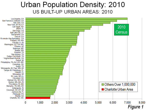
    This is borne out by the surprising stability of commute times over extended periods. According to the US Nationwide Household Travel Survey, explains Gordon, the average metropolitan commute time was 25 minutes 2009, just one minute more than in 2001, despite relevant population growth of 12 per cent. The averages for sub-area types described as ‘suburban’ and ‘second city’ were actually lower than for the ‘urban’ or core sub-area. Analysing the INRIX Traffic Congestion Scorecard and urban density data, demographer Wendell Cox also finds support for links between higher population densities and longer commute times.

    What about Randy’s other travails, are most suburbanites so estranged from their neighbours? A study cited by geographer Joel Kotkin found that for every 10 per cent drop in population density, the likelihood of people talking to their neighbours once a week rose 10 per cent. What about marital failure? Writing in the mid-2000s, Sue Shellenberger noted that ‘couples from central cities are 9 per cent more likely to crash and burn than couples from the suburbs, according to the National Center for Health Statistics.’ How about the prospect of winding up behind bars? On the basis of Brookings Institution research, Kotkin and Cox say suburban areas generally have substantially lower crime rates than ‘core cities.’

    (With their painstaking attention to statistics, Kotkin and Cox are the bêtes noires of pro-density urbanists, who tend to fall back on anecdotal evidence).

    ‘The masses will still need suburbia’  

    Use of Randy Straussner’s plight to discredit life on the urban fringe constitutes a classic Straw Man fallacy.

    From there, Montgomery proceeds to zig-zag between the fictional extremes of super-commuting hell and an opposite notion of high-rise ‘verticalism’, which he claims to reject. This dialectical type of approach has the advantage of inoculating him against the charge of ignoring inconvenient facts. In coming out for ‘a hybrid, somewhere between the vertical and horizontal city’, he gets to concede many pro-suburban realities, while clinging to his firmly anti-suburban conclusions.

    Concessions to suburbia on job location, home ownership and affordability, the popularity of driving, and economic dynamism are scattered throughout the book, intermixed with the general tone of disapproval.

    After many pages railing against ‘super-commuting’ and ‘detached houses with modest lawns … far from employment’, for instance, Montgomery is ready to admit that: ‘the US population is projected to grow by 120 million by 2050. Where will those people live? Downtowns and first-ring, streetcar-style suburbs will be able to accommodate only a fraction of the new demographic tidal wave. Most jobs have already moved out beyond city limits anyway.’ Then, quoting, he writes ‘the masses will still need suburbia.’

    This is noteworthy, since other green urbanists hold fast to the myth that jobs are concentrated in the urban core. Data in the 2011 American Community survey suggests that the ‘job-housing balance’, measuring the number of jobs per resident employee in a geographic area, is ‘nearing parity’ in suburban areas of US metropolitan regions with more than a million people. This isn’t dramatically different from the position in Australia’s 6 major cities, which have some of the world’s most dispersed patterns of employment (and will share an estimated 20 million more people by 2050). It’s all consistent with Gordon’s co-location thesis.

    In one chapter, Montgomery applauds his home town of Vancouver, which ‘has spent the past thirty years drawing people into density in a way that radically reversed a half century of suburban retreat.’ But he is forced to admit that ‘in 2012 Vancouver won the dubious honour of becoming the most expensive city for housing in North America. This means many people who work in the city … can’t afford to live there … ‘

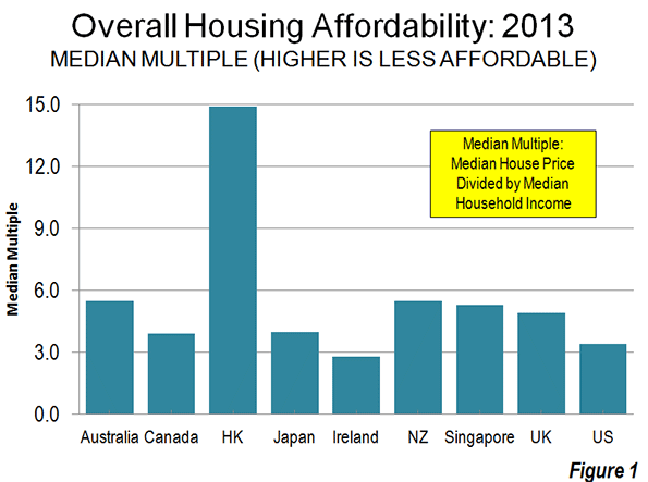
    More generally, he says ‘the forces of supply and demand have helped make housing in some of the world’s most liveable cities’ –  for which read dense cities – ‘the least affordable.’ Again: ‘as the wealthy recolonize downtowns and inner suburbs, and property values rise accordingly, millions of people are simply being excluded.’ (Always dialectical, Montgomery mostly heaps praise on dense places like Vancouver and Portland, usually rated severely or seriously ‘unaffordable’ in the Demographia International Housing Affordability Survey, while singling out dispersed Atlanta for rebuke, despite a consistent rating of ‘affordable’.)

    And noting the influence of Vancouver’s high-rise density, spawning the label ‘Vancouverism’, Montgomery feels compelled to mention that ‘people living in towers consistently reported feeling more lonely and less connected than people living in detached homes.’ Later he writes that ‘most of us also want to live in a detached home with plenty of privacy and space.’

    On driving, the book is full of complaints that ‘governments have continued the decades-old practice of pouring tax dollars into highways … while spending a tiny fraction of that amount on urban rail and other transit service.’ Yet there is also the qualification that: ‘drivers experience plenty of emotional dividends. When the road is clear, driving your own car embodies the psychological state known as mastery: drivers report feeling much more in charge of their lives than transit users or even their own passengers.’ Montgomery lets slip the truth on popular preferences with the comment, ‘roads left to the open market – in other words, dominated by private cars.’

    Accordingly, the American Community Survey reports that between 2007 and 2012, ‘driving alone’ increased as the dominant mode of commuting in the United States, rising from 76.1 to 76.3 per cent of work trips. This bears some relation to the co-location of suburban residents and businesses.

    ‘A marvellous thing’

    Amidst his oscillations, Montgomery sketches an overview that reads like an encomium to the blessings of suburbia:

    The rapid, uniform and seemingly endless replication of this dispersal system was, for many people and for many years, a marvellous thing. It helped fuel an age of unprecedented wealth. It created sustained demand for the cars, appliances and furniture that fuelled the North American [and Australian] manufacturing economy. It provided millions of jobs in construction and massive profits for land developers. It gave more people than ever before the chance to purchase their own homes on their own land, far from the noise and haste and pollution of downtown.

    Having acknowledged the housing, transportation, employment and wider economic advantages of dispersion and suburbanisation, Montgomery could have come to the conclusion that they offer opportunities for a better life to millions of people, and should be embraced as a legitimate option by officials and planners. But that’s not where he ends up. Insisting that the dispersed city is now ‘inherently dangerous’, he signs on for pro-density ‘new urbanism’, calling for an overhaul of zoning codes, approval processes, infrastructure planning, tax incentives and funding practices to stimulate denser and less car-dependent redevelopment, aiming for transit-friendly, walkable, mixed-use, town centres and clusters of attached town-houses and low-rise apartments.

    While ‘new urbanism’ sweeps aside the advantages of dispersion, Montgomery’s misconceived ideas show that it offers nothing better. Take housing affordability. At first he toys with the faddish notion of ‘a by-law stating that 15 per cent of dwellings in every new subdivision … must be suitable for people of low or moderate income’, a costly burden on new construction for developers and the majority of home buyers. As the Australian experience attests, this type of planning fails to offset the spike in land values which accompanies density.

    Then, sensing this is far from enough, his demands escalate to the socialisation of housing supply: ‘it’s not enough to nudge the market towards equity … Governments must step in with subsidized social housing, rent controls, initiatives for housing co-operatives, or other policy measures.’ The destructive impacts of these sorts of measures on investment, market efficiency, public finances, and freedom of choice are passed over.

    Later in the book, Montgomery discusses ways to draw developers into density and social housing, including changes to ‘infrastructure-funding rules, tax incentives and permit requirements.’ He contends that ‘if this sounds like a big fat bonus for property developers well it is … but the truth is, as long as we inhabit a capitalist system, the future of suburbia depends on them.’

    It’s just that this isn’t capitalism as much as rent-seeking at the expense of consumers and other businesses, suppressing economic growth, opportunities and living standards. But that’s not a bad outcome for someone who extols the joys of poverty.

    John Muscat is a co-editor of The New City, where this piece first appeared.

    This is part one of a two-part series. Read part two here.

  • Correcting Priorities: The 10th Annual Demographia Housing Affordability Survey

    Alain Bertaud of the Stern School of Business at New York University and former principal planner of the World Bank introduces the 10th Annual  Demographia International Housing Affordability Survey by urging planners to abandon:

    "…abstract objectives and to focus their efforts on two measurable outcomes that have always mattered since the growth of large cities during the 19th century’s industrial revolution: workers’ spatial mobility and housing affordability".

    This year’s edition has been expanded to nine geographies, including Australia, Canada, Hong Kong, Ireland, Japan, New Zealand, Singapore, the United Kingdom, and the United States. A total of 85 major metropolitan areas (of over 1,000,000 population) are covered, including five of the six largest metropolitan areas in the high income world (Tokyo-Yokohama, New York, Osaka-Kobe-Kyoto, London, and Los Angeles). Overall, 360 metropolitan markets are included.

    View the map with housing data for all markets created by the New Zealand Herald.

    The Affordability Standard

    The Demographia International Housing Affordability Survey uses a price-to-income ratio called the "median multiple," calculated by dividing the median house price by the median household income. Following World War II, virtually all metropolitan areas in Australia, Canada, Ireland, New Zealand, the United Kingdom, and the United States had median multiples of 3.0 or below. However, as urban containment policies have been implemented in some metropolitan areas, house prices have escalated well above the increase in household incomes. This is exactly the effect that economics predicts to occur where the supply of a good or service is rationed, all things being equal.

    Even a decade ago, there was considerable evidence of the rapidly deteriorating housing affordability in markets with urban containment policy. Yet, governments implementing these policies were largely ignoring not only the trends, but also any reference to the extent of the losses in historic context. Co-author Hugh Pavletich of Performance Urban Planning and I established the Demographia International Housing Affordability Survey to draw attention to this policy driven attack on the standard of living.

    The Demographia Survey rates housing affordability as follows:

    Demographia Housing Affordability Rating Categories

    Rating

    Median Multiple

    Severely Unaffordable

    5.1 & Over

    Seriously Unaffordable

    4.1 to 5.0

    Moderately Unaffordable

    3.1 to 4.0

    Affordable

    3.0 & Under

    Affordability in the 9 Geographies

    Among the nine geographies and all 360 markets, Ireland emerges has the most affordable, with a median market multiple of 2.8. The United States follows at 3.4, and Canada at 3.9. Japan’s median market multiple is 4.0, while the United Kingdom is at 4.9 and Singapore at 5.1 The other geographies are all well into the severely unaffordable category, including Australia and New Zealand, at 5.5, and far worse Hong Kong, at 14.9 (Figure 1).

    Costly Hong Kong & Vancouver, Affordable Pittsburgh and Atlanta

    For the fourth year in a row, Hong Kong is the least affordable major metropolitan area, with a median multiple of 14.9, three times its early 2000s ratio. Vancouver is again the second most unaffordable major market, with a median multiple of 10.3, three times its pre-urban containment level. Housing affordability in coastal California is well on the way to the stress of the 2000s. San Francisco ranks third most unaffordable at 9.2 and nearby San Jose is at 8.7, with San Diego (7.9) and Los Angeles (7.7) following closely. Sydney, at 9.0, ranks fourth with Melbourne at 8.4 and Auckland at 8.0.All of these metropolitan areas have had serious deterioration of housing affordability since adopting urban containment policy.

    All of the affordable major metropolitan areas are all in the United States. Pittsburgh is the most affordable, at 2.3. There are 13 additional major affordable housing markets, which include growing and over-5 million Atlanta as well as Indianapolis and Columbus, with their strong economies (Figure 2).

    Japan

    Notably, Japan’s two largest metropolitan areas, Tokyo-Yokohama and Osaka-Kobe-Kyoto have avoided the severely unaffordable territory occupied by the other three megacities (New York, Los Angeles, and London). Osaka-Kobe-Kyoto has the best housing affordability of any megacity, at 3.5 (moderately unaffordable) and Tokyo-Yokohama is at 4.4 (seriously unaffordable).

    House Size

    This year’s Demographia Survey also provides information on average new house size in the nine geographies (Figure 3). The largest houses are in the United States, which is second only to Ireland in affordability. The smallest houses are in Hong Kong, which also has the least affordable housing. In living space those who pay the most get the least, while those who pay the least get the most.

    The Imperative for Reform

    Housing is the largest element of household budgets, and its cost varies the most between metropolitan areas. Where households pay more than necessary for housing, they have less dicsretionary income and lower standards of living and there is more poverty. This is a natural consequence of planning policies that place the urban form above the well-being of people. One of the principal justifications is environmental, but the gains from urban containment policy are scant and exorbitantly expensive.

    Virtually all of the geographies covered in the Demographia Survey are facing more uncertain economic futures than in the past. As is always the case in such situations, lower income households tend to be at greatest risk, while younger households have much less chance of living as well as their parents (except those fortunate enough to inherit their wealth or housing).

    There is no more imperative domestic policy imperative than improving the standard of living and minimizing poverty. Planning must facilitate that, not get in the way. Bertaud is hopeful:

    "But if planners abandoned abstracts and unmeasurable objectives like smart growth, liveability and sustainability to focus on what really matters –  mobility and affordability – we could see a rapidly improving situation in many cities.  I am not implying that planners should not be concerned with urban environmental issues.  To the contrary, those issues are extremely important, but they should be considered a constraint to be solved not an end in itself."

    Download the full report (pdf):  10th Annual  Demographia International Housing Affordability Survey

    Photo: Suburban Tokyo (by author)

  • The Story of How Marin Was Ruined

    Marin County is a a picturesque area across the Golden Gate Bridge from San Francisco of quaint walkable towns, with homes perched on rolling hills and a low rise, unspoiled feel. People typically move to Marin to escape the more urbanized South and East Bay and San Francisco. Eighty-three percent of Marin cannot be built on as the land is agricultural and protected open space. 

    This is not stopping ABAG, developers, social equity, housing and transit advocates from pushing for high density housing near transit in Marin. Plans for high density housing have sprung up the length of the county – multiple Marin communities found themselves declared Plan Bay Area "Priority Development Areas" (PDAs) making them targets for intense high density development. These designations occurred with little or no consultation by the elected officials that had volunteered them, and without any clear understanding of obligations to develop or impact.

    Residents finally came together and said they’d had enough after an unsightly 5 story, 180 unit apartment complex appeared adjacent to an existing freeway choke-point – the city that allowed it had little choice due to onerous ABAG housing quotas that if unmet left the town open to litigation by housing advocates with crippling legal bills and penalties. The last straw was the publication of a station area plan to generate transit ridership that suggested 920 more high density units be built in nearby Larkspur – another freeway bottleneck. 

    This video, put together by Citizen Marin, a coalition of neighborhood groups seeking to restore local control, was put together to drive awareness of this accelerated urbanization. For Marinites the video serves as a wake up call – most moved to Marin to live in a more rural / suburban location. Marin offers some of California’s most walkable and attractive downtowns already: Sausalito, Mill Valley and San Rafael. All offer the kind of small town charm that are a model for others to emulate and attract visitors and residents.

    The video was written and produced by Citizen Marin’s Richard Hall. The video’s narrator is from San Rafael – not San Rafael in Marin County but San Rafael, Argentina, and the animation was put together by a team from Kathmandu Nepal.

  • Britain’s Planning Laws: Of Houses, Chickens and Poverty

    Perhaps for the first time in nearly seven decades a serious debate on housing affordability appears to be developing in the United Kingdom. There is no more appropriate location for such an exchange, given that it was the urban containment policies of the Town and Country Planning Act of 1947 that helped drive Britain’s prices through the roof. Further, massive damage has been done in countries where these polices were adopted, such as in Australia and New Zealand (now scurrying to reverse things) as well as metropolitan areas from Vancouver to San Francisco, Dublin, and Seoul.

    A healthy competition has developed between the Conservative-Liberal Democrat coalition and the Labour Party to finally address the problem of the resulting land and housing shortage that has driven prices up so much relative to incomes.

    It probably helps that public opinion seems to be changing. A recent MORI poll found that 57 percent of respondents considered rising house prices to be a bad thing for Britain, compared to only 20 percent who though it a good thing.

    It has been more than a decade since Kate Barker, then a member of the Monetary Policy Committee of the Bank of England (the central bank) was commissioned by the Blair Labor government to examine the issues. Her conclusions were clear. Britain has a serious housing affordability problem and its restrictive land use policies were the cause. These higher housing costs, the largest element or household expenditure have reduced the standard of living and increased poverty beyond what would have occurred if urban containment regulation had not destabilized house prices. The Economist notes that home ownership is falling and that the number of couples with children who are renting has tripled since the late 1990s.

    Planning and Chickens

    This week, The Economist weighed into the debate (Britain’s planning laws: An Englishman’s home):

    "Now that the economy is at last growing again, the burning issue in Britain is the cost of living. Prices have outstripped wages for the past six years. Politicians have duly harried energy companies to cut their bills, and flirted with raising the minimum wage. But the thing that is really out of control is the cost of housing. In the past year wages have risen by 1%; property prices are up by 8.4%. This is merely the latest in a long surge. If since 1971 the price of groceries had risen as steeply as the cost of housing, a chicken would cost £51 ($83)."

    For those of us unfamiliar with the cost of chicken in British hypermarkets, The Daily Mail says it is about £2 ($3). Indeed, even the chicken industry suffers, as planning restrictions  are getting in the way of adding the chicken farms Britain requires.

    Moreover, the high costs cited by The Economist are after the house prices increases that had already occurred by 1970. Even then, before such inflationary pressures were seen elsewhere, Sir Peter Hall characterized soaring land and house prices as the biggest failure of the 1947 Act. Hall had led a major research effort on the subject, which produced a two-volume work, The  Containment of Urban England (See The Costs of Smart Growth Revisited: A 40 Year Perspective).

    From Affordable to Unaffordable

    While the historic relationship between household incomes and house prices (the "median multiple") was under 3.0 across the United Kingdom as late as the 1990s, it has now deteriorated to more than 7.0 inside the London Greenbelt. Unbelievably it has risen to elevated levels even in the less prosperous the north of England. For example, depressed Liverpool has a median multiple over 5.0, which is 60 percent above the maximum historic range and making the metropolitan area "severely unaffordable." Liverpool is probably best compared to Cleveland in the United States for its economic distress.

    The shortage of housing in Britain has become acute. There are additional concerns that the globalization of housing markets has hit London particularly hard and is driving households out of the housing market.

    More Money, Less House

    Through all of this, Briton’s are getting less for their money. Since 1920, the average size of a new large family house has been reduced 30 percent. Semi-detached houses are 44 percent smaller and townhouses (terrace housing) is 37 percent smaller (Figure 1). Britain now has some of the smallest new housing in the world. The average new house in continental Europe is 50% or more larger than in England and Wales. New houses are two to three times as large in Canada, New Zealand, Australia and the United States (Note 1). In some US cities, residents can build "granny flats" which are larger than new houses in Britain. For example, San Diego’s limit for granny flats of 850 square feet exceeds Britain’s average new house size of 818 square feet.

    Paving Over Ohio?

    Of course, those who see urban expansion (the theological term is "sprawl") as ultimate evil imagine an England and Wales being literally paved over by allowing people to live as they prefer. They need not worry.

    For example, England and Wales is less crowded than spacious Ohio, with its rolling hills and extensive farmland. According to the 2011 census, only 9.6% of the land in England and Wales is urban, the other 90.4% is rural. In Ohio, on the other hand, 10.8% of the land is urban and only 89.2% of the land is rural. Even the state of Georgia, with the least dense large urban area in the world, Atlanta, has roughly as much rural land (91.7 percent) as England and Wales (Figure 3).

    Every Gram is Sacred?

    Originally, urban containment was justified on social and aesthetic grounds. However, curbing greenhouse gases is now used as the raison d’etre for highly restrictive housing policies. Urban policy in England and Wales and elsewhere has been hijacked by a philosophy that any gram of greenhouse gas that can be reduced must be, regardless of its impact on society, the economy, the standard of living or poverty.

    One of the worst conceivable strategies for reducing greenhouse gas emissions is to waste money on costly and ineffective measures. The Intergovernmental Panel on Climate Change (IPCC) has indicated that sufficient reductions in greenhouse gas emissions can be achieved for a range of from $20 to $50 per ton. Urban containment policy cannot deliver for this price. In contrast, improving automobile fuel efficiency is forecast improve greenhouse gas emissions, even as driving continues to rise with a growing population (see Urban Planning for People). In addition, the higher house prices associated with urban containment policy are well beyond the IPCC range.

    No program can produce substantial greenhouse gas emission reductions that does not focus on higher value strategies. Urban containment has no high value strategies.

    Planning, People and Poverty

    Britain’s land policy competition between the political parties is long overdue. Coalition Communities Secretary Eric Pickles, decries "the way families are trapped in ‘rabbit hutch homes’." The Labour Party opposition has promised that, if elected in 2015, steps will be taken to increase land supply and housing affordability, so that "working people and their children" have the "decent homes they deserve."

    The Economist states the issue squarely:

    "Building on fields in a country that is as crowded as England will always rile some people, however well-designed the system. But the alternative is worse: a nation of renters and rentiers, where only the rich own houses."

    —————–

    Note 1: As Figure 2 indicates, Hong Kong housing is considerably smaller than that of England and Wales. Hong Kong really is the ultimate smart growth or urban containment city. It has the highest urban population density in the high income world. It has the highest share of its commuters using mass transit to get to work. Its traffic congestion is intense. And, predictably, it has the highest house prices relative to incomes yet documented in the high income world.

    We need to be spared the "sun rises in the west" economic studies claiming that somehow the laws of economics, that work so relentlessly to drive up prices where supplies are constrained in other industries (such as petroleum, corn, etc.) have no effect on land and housing.

    Wendell Cox is a Visiting Professor, Conservatoire National des Arts et Metiers, Paris and the author of “War on the Dream: How Anti-Sprawl Policy Threatens the Quality of Life.

    Photo: St. Pancras Station (London), by author

  • Build It, Even Though They Won’t Come

    The recent decision by Los Angeles County Superior Court Judge Allan J. Goodman to reject as “fatally flawed” the densification plans for downtown Hollywood could shake the foundations of California’s “smart growth” planning clerisy. By dismissing Los Angeles’ Hollywood plan, the judge also assaulted the logic behind plans throughout the region to construct substantial high-rise development in “transit-oriented developments” adjacent to rail stations.

    In particular, the judge excoriated the buoyant population-growth projections used to justify the plan, a rationalization for major densification elsewhere in the state. The mythology is that people are still flocking to Los Angeles, and particularly, to dense urban areas, creating a demand for high-end, high-rise housing.

    The Hollywood plan rested on city estimates provided by the Southern California Association of Governments, which estimated that Hollywood’s population was 200,000 in 2000 and 224,000 in 2005, and would thus rise to 250,000 by 2030. All this despite the fact that, according to the census, Hollywood’s population over the past decade has actually declined, from 213,000 in 1990 to 198,000 today. Not one to mince words, Judge Goodman described SCAG’s estimates as “entirely discredited.”

    This discrepancy is not just a problem in the case of Hollywood; SCAG has been producing fanciful figures for years. In 1993, SCAG projected that the city of Los Angeles would reach a population of 4.3 million by 2010. SCAG’s predicted increase of more than 800,000 residents materialized as a little more than 300,000. For the entire region, the 2008 estimates were off by an astounding 1.4 million people.

    Similar erroneous estimates run through the state planning process. In 2007, California’s official population projection agency, the Department of Finance, forecast that Los Angeles County would reach 10.5 million residents in just three years. But the 2010 U.S. Census counted 9.8 million residents.

    Such inflated estimates, however, do serve as the basis for pushing through densification strategies favored by planners and their developer allies. In fact, SCAG’s brethren at the Association of Bay Area Governments, seeking to justify their ultradense development plan, recently went beyond even population estimates issued by the Department of Finance.

    The problem here is not that some developers may lose money on projects for which there is inadequate demand, but that this densification approach has replaced business development as an economic strategy. Equally bad, these policies often threaten the character of classic, already-dense urban neighborhoods, like Hollywood. Indeed, the Los Angeles urban area is already the densest in the United States, and a major increase in density is sure to further worsen congestion.

    Not surprisingly, some 40 neighborhood associations and six neighborhood councils organized against the city’s Hollywood plan. Their case against the preoccupation with “transit-oriented development” rests solidly on historical patterns. Unlike in New York City, much of which was built primarily before the automobile age, Los Angeles has remained a car-dominated city, with roughly one-fifth Gotham’s level of mass-transit use. Despite $8 billion invested in rail lines the past two decades, there has been no significant increase in L.A.’s transit ridership share since before the rail expansion began.

    The Hollywood plan is part of yet another effort to reshape Los Angeles into a West Coast version of New York, replacing a largely low-rise environment with something former Mayor Antonio Villaraigosa liked to call “elegant density.” As a councilman, new Mayor Eric Garcetti proclaimed a high-rise Hollywood as “a template for a new Los Angeles,” even if many Angelenos, as evidenced by the opposition of the neighborhood councils, seem less than thrilled with the prospect.

    If the “smart growth” advocates get their way, Hollywood’s predicament will become a citywide, even regional, norm. The city has unveiled plans to strip many single-family districts of their present zoning status, as part of “a wholesale revision” of the city’s planning code. Newly proposed regulations may allow construction of rental units in what are now back yards and high-density housing close to what are now quiet residential neighborhoods.

    “They want to turn this into something like East Germany; it has nothing to do with the market,” suggests Richard Abrams, a 40-year resident of Hollywood and a leader of Savehollywood.org. “This is all part of an attempt to worsen the quality of life – to leave us without back yards and with monumental traffic.”

    Of course, it is easy to dismiss community groups as NIMBYs, particularly when it’s not your neighborhood being affected. But here, the economics, too, make little sense. New, massive “luxury” high-rise residential buildings were not a material factor in the huge density increases that made the Los Angeles urban area more dense than anywhere else in the nation during the second half of the 20th century. Even in New York City, the high-rise residential buildings where the most affluent live are concentrated in the lower half of Manhattan; they house not even 20 percent of the city’s population.

    Under any circumstances, the era of rapid growth is well behind us. In the 1980s, the population of Los Angeles grew by 18 percent; in the past decade, growth was only one-fifth as high. Growth in the core areas, including downtown, overall was barely 0.7 percent, while the population continued to expand more rapidly on the city’s periphery. Overall, the city of Los Angeles grew during the past decade at one-third the national rate. This stems both from sustained domestic outmigration losses of 1.1 million in Los Angeles County and immigration rates that have fallen from roughly 70,000 annually in the previous decade to 40,000 a year at present.

    Nor can L.A. expect much of a huge infusion of the urban young talent, a cohort said to prefer high-density locales. In a recent study of demographic trends since 2007, L.A. ranked 31st as a place for people aged 20-34, behind such hot spots as Milwaukee, Oklahoma City and Philadelphia. It does even worse, 47th among metro areas, with people ages 35-49, the group with the highest earnings.

    In reality, there is no crying need for more ultradense luxury housing – what this area needs more is housing for its huge poor and working-class populations. More important, we should look, instead, at why our demographics are sagging so badly. The answer here, to borrow the famous Clinton campaign slogan: It’s the economy, stupid. In contrast with areas like Houston, where dense development is flourishing along with that on the city’s periphery, Southern California consistently lands near the bottom of the list for GDP, income and job growth, barely above places like Detroit, Cleveland or, for that matter, Las Vegas.

    Despite many assertions to the contrary, densification alone does not solve these fundamental problems. The heavily subsidized resurgence of downtown Los Angeles, for example, has hardly stemmed the region’s relative decline.

    Instead of pushing dense housing as an economic panacea, perhaps Mayor Garcetti should focus on why the regional economy is steadily falling so far behind other parts of the nation. One place to start that examination would be with removing the regulatory restraints that chase potential jobs and businesses – particularly better-paying, middle class ones – out of the region. It should also reconsider how the “smart growth” planning policies have helped increase the price of housing, particularly for single-family homes, preferred by most families.

    At the same time, the mayor and other regional leaders should realize that L.A.’s revival depends on retaining the very attributes – trees, low-rise density, sunshine, as well as entrepreneurial opportunity – that long have attracted people. People generally do not migrate to Los Angeles to live as they would in New York or Chicago. Indeed, Illinois’ Cook County (Chicago) and three New York City boroughs – Manhattan, Queens and Brooklyn – are among the few areas from which L.A. County is gaining population. Where are Angelinos headed? To relatively lower-density places, such as Riverside-San Bernardino, Phoenix and Houston.

    Under these circumstances, pushing for more luxury high-rises seems akin to creating structures for which there is little discernible market. Once demographic and economic growth has been restored broadly, it is possible that a stronger demand for higher-density housing may emerge naturally. Until then, the higher density associated with “smart growth” neither addresses our fundamental problems, nor turns out to be very smart at all.

    This story originally appeared at The Orange County Register.

    Joel Kotkin is executive editor of NewGeography.com and Distinguished Presidential Fellow in Urban Futures at Chapman University, and a member of the editorial board of the Orange County Register. He is author of The City: A Global History and The Next Hundred Million: America in 2050. His most recent study, The Rise of Postfamilialism, has been widely discussed and distributed internationally. He lives in Los Angeles, CA.

  • The Evolving Urban Form: Charlotte

    There may be no better example of the post World War II urban form than Charlotte, North Carolina (a metropolitan area and urban area that stretches into South Carolina). Indeed, among the approximately 470 urban areas with more than 1 million population, Charlotte ranks last in urban population density in the United States (Figure 1) and last in the world. According to the United States Census Bureau, Charlotte’s built-up urban area population density was 1685 per square mile (650 per square kilometer) in 2010. Charlotte is not only less dense than Atlanta, the world’s least dense urban area with more than 4,000,000 residents, but it is only one-quarter the density of the supposed  “sprawl capital” of Los Angeles (Figure 2).

    Over the last seven decades, Charlotte also has been among the fastest growing metropolitan areas in the United States. Charlotte is the county seat of Mecklenburg County, and as recently 1940 as was home to 101,000 residents while with its suburbs in Mecklenburgh County was barely 150,000.

    Declining Densities in the Core City

    Charlotte is also in example of the difficulty of using the core municipality data for comparisons to the suburban balance of metropolitan areas. With North Carolina’s liberal annexation laws, Charlotte has pursued a program of nearly continuous annexation such that in every 10 years since 1940, the city has added substantial new territory.

    In 1940, the city of Charlotte covered a land area of 19 square miles (50 square kilometers) and had a population density of 5200 per square mile (2,000 per square kilometer). For a prewar core municipality, this was not at all dense. For example, Evansville Indiana, which had approximately the same population at the time, had a population density nearly twice that of Charlotte. Other larger core municipalities approached triple or more Charlotte’s population density, such as Trenton, Buffalo, Providence, and Milwaukee.

    Over the last seven decades, the city’s population has risen by 6.2 times, while its land area has increased by 14.4 times (Table $$$). The result is a 53% decline in the city of Charlotte’s population density, to 2456 per square mile (948 per square kilometer). This is only slightly above average density of the US built-up urban area – which includes the smallest towns and suburbs of every size – of 2,343 per square mile (1,455 per square kilometer). Indeed, the average far flung suburbs (30 miles distant) of Los Angeles, such as Pomona and Tustin, are more than 2.5 times as dense.

    City of Charlotte (Municipality)
    Population & Land Area: 1940-2010
    Census Population Area: Square Miles Area: Square KM Density (Sq. Mile) Density (KM)
    1940           100,899 19.3 50.0          5,228          2,019
    1950           134,042 40.0 103.6          3,351          1,294
    1960           201,564 64.8 167.8          3,111          1,201
    1970           241,178 76.0 196.8          3,173          1,225
    1980           314,447 139.7 361.8          2,251             869
    1990           395,934 174.3 451.4          2,272             877
    2000           567,943 242.3 627.6          2,344             905
    2010           731,424 297.8 771.3          2,456             948
    Change 625% 1443% 1443% -53.0% -53.0%


    Growth by Geography

    The core city of Charlotte’s ever-fluctuating boundaries make it necessary to use smaller area measures to estimate the distribution of population growth. This can be accomplished using zip code data from the 2000 and 2010 censuses.

    Inner Charlotte, for the purposes of this analysis (zip codes 28202 through 28208) covers approximately 28 square miles (73 square kilometers) and had a population of approximately 92,000 in 2010 . This is a larger area than the city of Charlotte in 1940, which covered only two thirds as much land area and had more people. Between 2000 and 2010, this inner area population rose by 6,200 residents. All the gain was in the central zip code that comprises the downtown area (central business district), which in Charlotte is called "Uptown." Outside this small 1.8 square mile area (4.7 square kilometers), the inner area actually lost 1,400 residents.

    Overall, the inner area of Charlotte – which has somewhat an obsessive hold on many city leaders – accounted for 1.0% of the metropolitan area growth from 2000 to 2010. This is not unlike other major metropolitan areas, which have experienced slow growth, particularly in areas adjacent to the downtown cores. Among the 51 US metropolitan areas with more than 1,000,000 population in 2010, net gain occurred within two miles of city hall, while this gain was erased by a loss of 272,000 between two and five miles of city hall.

    Another 13% (64,000) of the 2000-2010 growth occurred in the middle Mecklenburg County zip codes (28209 to 28217), virtually all of which is in the city of Charlotte. This 185 square mile area, combined with the inner area, exceeds the land area of the city in 1990.

    Mecklenburg County’s outer zip codes, many of which are in the city, captured 37% of the metropolitan area’s growth (184,000). The remaining 49% (247,000) of growth in the Charlotte metropolitan area was outside Mecklenburg County (Figure 3).

    From 1990 to 2010, Charlotte was the seventh fastest growing metropolitan area out of the 51 with a population exceeding 1 million. Early data for the present decade shows Charlotte to have slipped to ninth fastest growing; however during this period, Charlotte has displaced Portland, Oregon as the nation’s 23rd largest metropolitan area. Between 1990 and 2012, Charlotte added nearly 1,000,000 residents and now has 2.4 million residents.

    Uptown: The Commercial Story

    Unlike other post-World War II metropolitan areas (such as Phoenix, San Jose, and Riverside-San Bernardino), Charlotte has developed a concentrated, high rise downtown area." Part of this is due to the city’s strong financial sector. Charlotte is the home to Bank of America, the nation’s second largest bank and the successor to the San Francisco-based California bank of the same name that was the largest bank in the world for decades. Nation’s Bank, the predecessor to Bank of America, erected a 60 story tower in 1992 that was among the tallest in the United States.

    Charlotte was also home to Wachovia Bank, which built its 42 floor headquarters before, and nearby the Bank of America Tower. Wachovia had intended to move to a larger, 50 story building. However, the time it was completed, Wachovia had been sold to Wells Fargo Bank, a casualty of the US financial crisis. The new building was renamed the Duke Energy Center.

    Thus, Charlotte consumed one San Francisco bank, and lost another to San Francisco. Now Uptown Charlotte has six buildings more than 500 feet in height (152 meters). With six buildings of this height,  Charlotte has developed by far the concentrated central business district among the newer metropolitan areas.

    However, the high employment density has not converted into a transit oriented business district, as some might have predicted. American Community Survey (CTPP) data indicates that approximately 87% of uptown employees use cars to get to work. Further, more than 90% of the jobs in the metropolitan area are outside Uptown.

    Uptown: The High Rise Condominium Story

    Uptown’s commercial progress has not been replicated in the residential market, as overzealous high rise condominium developers apparently may have confused Charlotte for Manhattan or Hong Kong. One of the more recent 500 foot plus towers was The Vue, a 50 story condominium tower. Too few condominiums were sold, and a foreclosure auction followed. The new owner has converted the condominiums to rental units. A 40 story condominium project ("One Charlotte") was to feature units priced from $1.5 million to $10 million, but was cancelled. Another condominium building, the 32 story 300 South Tryon was also cancelled. A tower base was prepared for a 50 plus story condominium monolith, but this was never built, while depositors were claiming they could not find the developer to get their deposits back. It was also reported that legendary developer Donald Trump had plans for the tallest building in town, a 72 story condominium tower, which would have been joined by another tower. These have also been cancelled (for artists renderings, click here).

    Charlotte’s Continuing Dispersion

    While Uptown condominium developers were unable to sell many units, Charlotte’s labor market dispersed so much between 2000 and 2010 that the Office of Management and Budget expanded the metropolitan area by four counties. The net addition to the population of this revision was approximately 460,000.  This is by far the largest percentage increase to a metropolitan area over the period, though much larger New York added counties with 660,000 residents.

    Charlotte seems to say it all with respect to the ill-named "back to the city movement" (ill named, because most suburbanites did not come from the city to begin with). Yes, there is growth downtown and yes, it is important and yes, it is healthy. But, in the overall scheme of things, it is small, and relative to the rest of the thriving region, likely to remain less important in the years ahead.

    Wendell Cox is a Visiting Professor, Conservatoire National des Arts et Metiers, Paris and the author of “War on the Dream: How Anti-Sprawl Policy Threatens the Quality of Life.

    Photo: Uptown Charlotte courtesy of Wiki Commons user Bz3rk

  • Urban Planning For People

    The recent publication of the United States Department of Energy, Energy Information Administration’s (EIA) 2014 Annual Energy Outlook provides a good backdrop for examining the importance of current information in transportation and land-use planning. I have written about two recent cases in which urban plans were fatally flawed due to their reliance on outdated information. In one case, San Francisco’s Plan Bay Area, the planners are ignoring reality, and a court challenge is underway. In the other, a court invalidated the city of Los Angeles Hollywood Plan.

    Progress In Automobile CO2 Emissions

    The new Annual Energy Outlook forecasts continuing and material progress in improving energy efficiency, reducing fossil fuel consumption and reducing carbon dioxide emissions from cars and light trucks (light vehicles). Per capita carbon dioxide emissions from light vehicles are projected by EIA to fall to 51 percent below the peak year of 2003 (Figure 1).

    The gross (not per capita) 2040 carbon dioxide reduction from light vehicles is projected to decline 28 percent in 2040 from 2003. Most significantly, the reduction is to occur as gross driving miles increases 29 percent (Figure 2). The actual 2040 emissions are likely to be even lower, because the 2014 Annual Energy Outlook assumes no vehicle fuel economy improvements after 2025. Improvements in vehicle technologies and cars using alternative fuels, and under government incentives, seem likely.

    The emissions forecast improvements have been stunning, to say the least. The 2002 Annual Energy Outlook had expected a 46 percent increase in carbon dioxide emissions from light vehicles between 2000 and 2020. The revised forecast – which takes into account what actually has occurred – says there will be a 9 percent decrease.

    This is the result of multiple factors. In 2002, EIA predicted a 55 percent increase in driving between 2000 and 2020. The 2014 Annual Energy Outlook revises that figure to 22 percent (Figure 3). Fuel economy is improving, which is being driven by stronger regulations as well as technological advances.  

    Driving is Down

    Driving per capita fell nine percent from the peak year of 2003 to 2012. This decline is not surprising given the sorry state of the economy and high unemployment. Gas prices have risen 85 percent (inflation adjusted) over the same period. The decline in driving is modest compared to the increase in gas prices – a 0.9 percent reduction in driving per capita for each 10 percent increase in gasoline (Figure 4), inflation adjusted. This is half or less the reduction in transit ridership that would be expected if fares were raised by the same percentage.  

    Meanwhile, little of this reduction in driving has been transferred to transit. The increase in transit per passenger miles per capita captured less than one percent of the driving decline. Indeed, the daily increase in per capita transit use is less than the perimeter of a 20-to-the-acre townhouse lot.

    With fewer jobs, higher gas prices and the new reliance on social media, as well as a rise in people working at home, people may have become more efficient and selective in their driving patterns (such as by consolidating shopping trips). Certainly those with jobs use their cars for those trips above as much as before.

    Meanwhile, the EIA forecasts that driving per capita will rise gain, once the economy is released from intensive care. However, with the near universality of automobile ownership, the potential for substantial increases is very limited.

    Hiding Success?

    It might be thought that the planning community, with its emphasis on reducing greenhouse gas emissions, would be rushing to incorporate these into their plans and even to herald the improvements.

    Yet, this is not the case. San Francisco Bay Area planners hid behind over-reaching state directives to "pretend-it-was yesterday" and employed out of date forecasts for vehicle emissions. Data in Plan Bay Area documentation shows that 95 percent of the projected improvement in greenhouse gas emissions would be from energy efficiency improvements. These have nothing whatever to do with its intrusive land use and transport strategies. The additional five percent requires social engineering residents into "pack and stack" high density developments, virtually outlaw detached housing on plentiful urban fringe land and will likely cause even more intense traffic congestion.

    California’s high speed rail planners have made the same kind of mistake, using out-dated fuel economy data in their excessively optimistic greenhouse gas emissions reductions.

    The Illusion of Transit Mobility

    Part of the problem is an illusion that people in the modern metropolitan area can be forced out of their cars into transit, walking, and biking, without serious economic impacts (such as a lower standard of living and greater poverty).

    Transit is structurally incapable of providing automobile competitive mobility throughout the metropolitan area without consuming much or all of its personal income (of course, a practical impossibility). But there is no doubt of transit effectiveness and importance in providing mobility to the largest central business districts (downtowns) with their astronomic employment densities (Note 1). Yet, outside the relatively small dense cores, automobile use is dominant, whether in the United States, Canada, Australia, or Western Europe. The transit legacy cities (municipalities) of New York, Chicago, Philadelphia, San Francisco, Boston, and Washington, with the six largest downtown areas account for 55 percent of all transit commuting in the United States.

    The Delusion of Walking and Cycling as Substitutes for Driving

    Illusion becomes delusion when it comes to cycling and walking. Walking and cycling work well for some people for short single purpose trips, especially in agreeable weather. However, walking and cycling are inherently unable to provide the geographical mobility on which large metropolitan areas rely to produce economic growth. True, cycling does approximate transit commute shares in smaller metropolitan areas, like Amsterdam, Rotterdam, and Bremen, but still accounts for barely a third of commuting by car according to Eurostat data. Prud’homme and Lee at the University of Paris and others have shown in their research that the economic performance of metropolitan areas is better where more of an area’s employment can be reached within a specific period of time (such as 30 minutes). That leaves only a limited role for walking and cycling.

    Toward an A Non-Existent Nirvana?

    The "Nirvana" of a transit-, walking-, and cycling-oriented metropolitan area proves to be no Nirvana at all. We don’t need theory to prove this point. Take Hong Kong, for example, with its urban population density six times that of Paris, nine times that of Toronto, 10 times Los Angeles, 12 times New York nearly 20 times Portland, and nearly 40 times that of Atlanta.

    This vibrant, exciting metropolitan area cannot deliver on a standard of living that competes with Western Europe, much less the United States. Despite the high density, the overwhelming dominance of transit, walking, and cycling, Hong Kongers spend much longer traveling to and from work each day than their counterparts in all large US metropolitan areas, including New York and in most cases the difference is from more than 50 percent (as in Los Angeles) to nearly 100 percent.

    The problem goes beyond the time that could be used for more productive for rewarding activities. Housing costs are the highest among the major metropolitan areas in the eight nations covered by the Demographia International Housing Affordability Survey. Hong Kong’s housing costs relative to incomes are more than 1.5 times as high as in the San Francisco metropolitan area and almost five times as high as Dallas-Fort Worth. Meanwhile, the average new house in Hong Kong is less approximately 485 square feet (45 square meters), less than one-fifth the size of a new single family US American house (2,500 square feet or 230 square meters), though Hong Kong households, are larger (Note 2).

    When households are required to spend more of their income for housing, they have less discretionary income and necessarily a lower standard of living. This loss of discretionary income trickles down to people in poverty, whose numbers are swelled by higher than necessary housing costs.

    Planning is for People

    Contrary to the current conventional wisdom, the prime goal of planning should not be to achieve any particular urban form. What should matter most is the extent to which a metropolitan area facilitates a higher standard of living and less poverty.

    ——————

    Note 1: In 2000, employment densities in the nation’s six largest downtown areas (New York, Chicago, Washington, Boston, San Francisco and Philadelphia) was three times that of the downtowns in the balance of the 50 largest urban areas, and 14 times as dense as outside the downtown areas.

    Note 2: According to the 2011 census, the average household size in Hong Kong was 2.9 persons. This is more than 10 percent larger than the US figure of 2.6 from the 2010 census.

    ——-

    Wendell Cox is a Visiting Professor, Conservatoire National des Arts et Metiers, Paris and the author of “War on the Dream: How Anti-Sprawl Policy Threatens the Quality of Life.

    Photo: Prius photo by Bigstock.