Category: planning

  • California: The Republic of Climate

    To some progressives, California’s huge endorsement for the losing side for president reflects our state’s moral superiority. Some even embrace the notion that California should secede so that we don’t have to associate with the “deplorables” who tilted less enlightened places to President-elect Donald Trump. One can imagine our political leaders even inviting President Barack Obama, who reportedly now plans to move to our state, to serve as the California Republic’s first chief executive.

    As a standalone country, California could accelerate its ongoing emergence as what could be called “the Republic of Climate.” This would be true in two ways. Dominated by climate concerns, California’s political leaders will produce policies that discourage blue-collar growth and keep energy and housing prices high. This is ideal for the state’s wealthier, mostly white, coastal ruling classes. Yet, at the same time, the California gentry can enjoy what, for the most part, remains a temperate climate. Due to our open borders policies, they can also enjoy an inexhaustible supply of cheap service workers.

    Of course, most Californians, particularly in the interior, will not do so well. They will continue to experience a climate of declining social mobility due to rising costs, and businesses, particularly those employing blue-collar and middle-income workers, will continue to flee to more hospitable, if less idyllic, climes.

    California in the Trump era

    Barring a rush to independence, Californians now must adapt to a new regime in Washington that does not owe anything to the state, much less its policy agenda. Under the new regime, our high tax rates and ever-intensifying regulatory regime will become even more distinct from national norms.

    President Obama saw California’s regulatory program, particularly its obsession with climate change, as a role model leading the rest of the nation — and even the world. Trump’s victory turns this amicable situation on its head. California now must compete with other states, which can only salivate at the growing gap in costs.

    At the same time, foreign competitors, such as the Chinese, courted by Gov. Jerry Brown and others to follow its climate agenda, will be more than happy to take energy-dependent business off our hands. They will make gestures to impress what Vladimir Lenin labeled “useful idiots” in our ruling circles, but will continue to add coal-fired plants to power their job-sapping export industries.

    Read the entire piece at The Orange County Register.

    Joel Kotkin is executive editor of NewGeography.com. He is the Roger Hobbs Distinguished Fellow in Urban Studies at Chapman University and executive director of the Houston-based Center for Opportunity Urbanism. His newest book, The Human City: Urbanism for the rest of us, was published in April by Agate. He is also author of The New Class ConflictThe City: A Global History, and The Next Hundred Million: America in 2050. He lives in Orange County, CA.

    Photo: By User “Neon Tommy” (https://www.flickr.com/photos/neontommy/8117052872) [CC BY-SA 2.0], via Wikimedia Commons

  • Big Box Jesus

    One of my cousins recently attended an event at a suburban church and I tagged along. I’m amoral and omnivorous. I’ll go to any house of worship on the odd chance I might actually learn something useful – and I often do. And I meet a lot of really nice people along the way. But mostly I like to explore the landscapes other people inhabit. Church provides an intimate glimpse into what people are thinking and feeling in a particular location.

    I was immediately impressed with how much this church looked and functioned like a shopping mall. The size, shape, and general construction of the buildings and surrounding parking lots were indistinguishable from a large retail center. I spent more time than I probably should have trying to figure out which denomination it was. Catholic? Definitely not. Lutheran? Not exactly. Baptist? Meh. Mormon? Nope. It was a generic all inclusive Christian arrangement that celebrated the lack of any specific affiliation. Come and worship. We take all kinds. And enjoy the ample free parking and food court while you’re here. There was a well populated Christian school, a substantial auditorium, and all manner of programs and facilities. It was a highly successful suburban version of Big Box Jesus.

    The event my cousin was attending wasn’t strictly religious in nature. It was more of a collection of speakers who each preached a version of financial independence with a Christian slant. The majority of the attendees were suburban women like my cousin looking to start or improve an independent business venture.

    A borrower is a slave to his master. A thousand heads nodded. Always set aside 25% of everything you earn. The congregants listened intently. Start small and build up incrementally. There were biblical parables about prudence leading to abundance. Knowing smiles of agreement followed. There were some folksy stories about the misguided foolishness good people often stumble into. Laughs ensued from the audience. I liked these people.

    But then I looked out at the parking lot. How many people paid cash for their cars? I explored the subdivisions all around the church. How many people bought their suburban homes with cash? How many people are capable of setting aside even a sliver of savings on a regular basis ever. How many people bought their clothes and shoes and had their hair done with a credit card that got rolled over into a big ball of vague but gradually mounting debt? How many people are approaching middle age and still paying off student loan debt?

    I understand the dynamics of contemporary accounting. Carrying mortgage debt provides a substantial tax advantage. Using “other people’s money” at a low interest rate to invest in an asset that consistently rises in value is smart and frees up cash to be deployed in other more productive ways. Putting cash into savings is inefficient since it sits in a bank earning near zero interest these days. Stock values keep rising so investing in equities is a no brainer.

    You can’t go around wearing thrift store clothes and sporting a bowl haircut and expect to be taken seriously in a professional business setting. You don’t want to drive around in an old clunker and put your family at risk when you could have the latest safety and reliability features of a newer car bought on credit. If you can buy that car with a home equity loan and get the tax deduction, all the better. Everything about respectable modern life is predicated on people spending a certain amount of money in a very specific way that is nearly impossible to achieve on a cash basis. And that set of arrangements is in direct conflict with the traditional virtues of frugality, saving, and self reliance. Big Box Jesus takes Visa, Mastercard, and American Express.

    This particular suburb is still very much in the aggressive growth phase of development. Everything is shiny and new. Did the developers build this town on a cash basis? No. It’s built on an Everest of commercial debt. How many of the people at the church earn their living selling real estate, or cars, or brokering mortgages, or refinancing people’s obligations, or helping them manage their stock portfolios? How many people are critically dependent on other people buying their products or services on credit? One way or another… almost everyone.

    Is the city paying as it goes for infrastructure with funds set aside for maintaining and replacing all the pipes, pumps, and pavement when they wear out? Are pensions fully funded? Will this development pattern generate enough taxable value as it ages to support and maintain all the critical public infrastructure of schools, police, and fire protection? I’ve spent a lot of time exploring the municipal finances of towns all over the country for years. They’re all functionally insolvent beyond a certain not-too-distant point.

    What all these practices and institutions need – what they can’t function without – is constant growth based on ever more leverage and debt. This can’t go on forever. Sooner or later there’s going to have to be a day of reckoning when the whole house of cards comes down. If I were a religious man I’d start praying right about now. Instead, I actually do what the preachers say. Pay cash, live below your means, save for the future, and opt out of the situations that trap you in a dysfunctional living arrangement with no future.

    John Sanphillippo lives in San Francisco and blogs about urbanism, adaptation, and resilience at granolashotgun.com. He’s a member of the Congress for New Urbanism, films videos for faircompanies.com, and is a regular contributor to Strongtowns.org. He earns his living by buying, renovating, and renting undervalued properties in places that have good long term prospects. He is a graduate of Rutgers University.

    All photos by Johnny Sanphillippo

  • Canada’s Urban Areas: Descent from Affordability

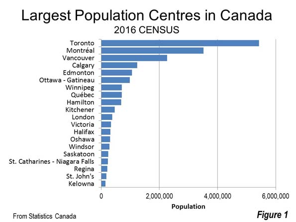
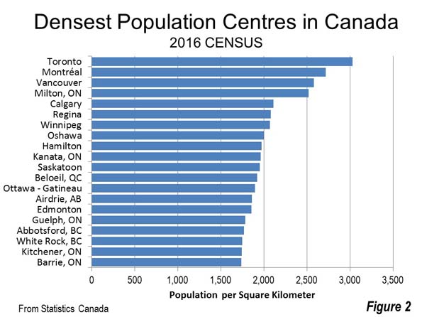
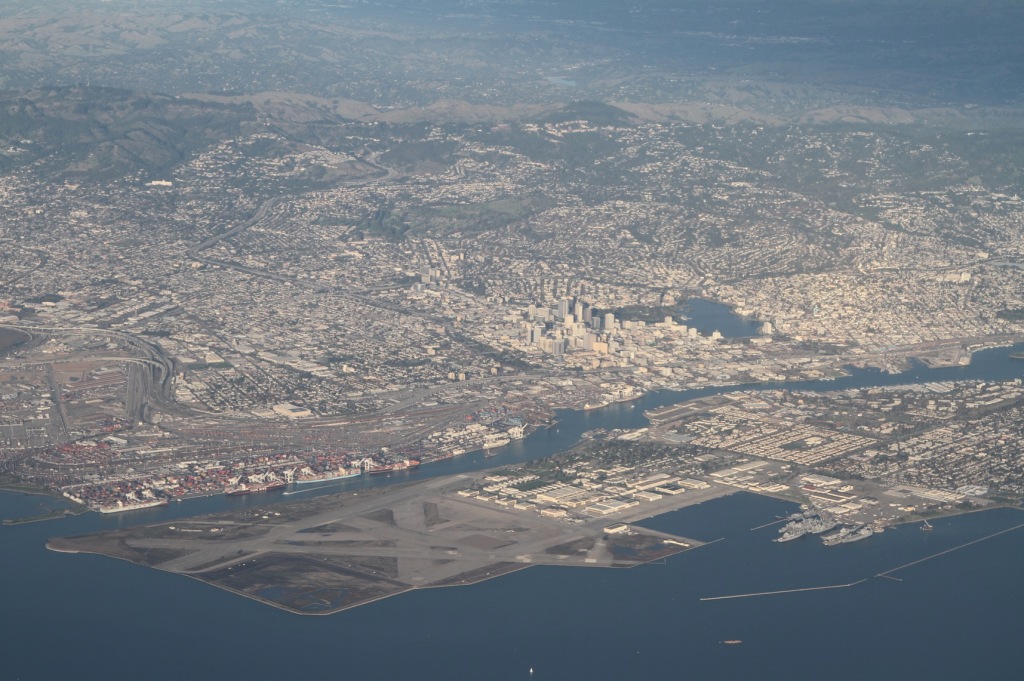
    Canada is a nation of wide open spaces, yet it has high urban area densities recently driven higher by a redefinition of urban area criteria (Note 1). Canada’s largest urban area (population centre) is Toronto, with a population of 5.4 million continues to be the densest of the 59 with more than 50,000 residents. Toronto has a population of 3,028 per square kilometer (7,843 per square mile), approximately five percent above the European Union average. Montréal (population of 3.5 million) has a density of 2,720 per square kilometer (7,045 per square mile), followed by third ranked Vancouver (2,584/6,693), which has a population of 2.2 million.  The top ten is rounded out by Milton, a fast growing Toronto exurb with a density of 2,520 per square kilometer or 6.527 per square mile, Calgary (2,112/5,470), Regina, the capital of Saskatchewan (2,082/5,391) and Winnipeg, which has seen renewed recent growth (2,070/5,360).

    Four other population centres have densities greater than 1,950 per square kilometer (5,000 per square mile , including  Oshawa and Hamilton, which are adjacent to Toronto, as well as Saskatoon, Saskatchewan and Kanata, an exurb of Ottawa (Figure 2).

    Comparisons to the United States

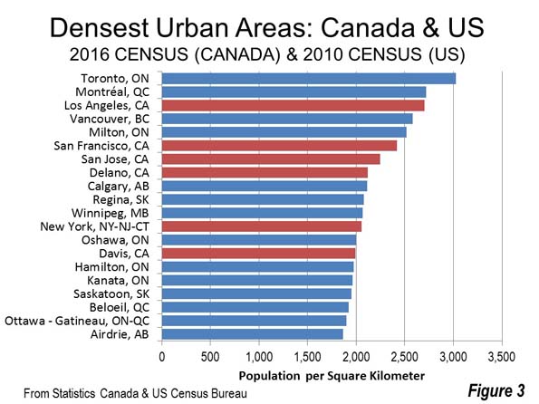
    The new, higher density figures are not surprising considering the especially compact suburbs in view when landing at Pearson Airport in Toronto, or even in Calgary or Edmonton. A combined Canada-US urban area density list illustrates the higher density of Canadian urban areas relative to those in the United States.  Among the five densest urban areas in Canada and the United States, four are in Canada. Los Angeles, the densest large urban area in the United States for the last three censuses, ranks third behind Toronto and Montréal. Vancouver and Milton rank fourth and fifth, just ahead of 6th ranked San Francisco. Immediately behind San Francisco is virtually all post-World War II suburban San Jose. Delano, California, an exurb of Bakersfield in the San Joaquin Valley has about 55,000 residents and ranks 8th on the combined list.

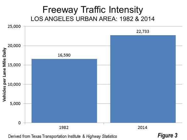
    Residents of Calgary, Regina and Winnipeg, where densification advocates repeatedly condemn their perceived local urban sprawl (a pejorative term for urban dispersion) will doubtless be surprised to know that their population density exceeds that of New York. Only one more US urban area makes the top 20, Sacramento exurb Davis, at 14th, with a population of 73,000 (Figure 3).

    Where’s Portland?

    To those inclined to venerate Portland’s internationally famous densification policies, this list may be disconcerting. Calgarians who bemoan the inferiority of their city in relation to Portland should be heartened to find out that Calgary’s density is more than 50 percent higher than Portland’s (Calgary’s transit market share is more than double Portland’s).

    Portland is not among the densest 20 urban areas , but ranks 72nd, just behind all-suburban Riverside-San Bernardino and a bit ahead of Halifax. If Portland were in Canada, it would rank 38th in population density out of the largest 59 urban areas.

    And Boston?

    Boston has a reputation as one of the densest cities in the United States. Yet, Boston’s huge urban area  is denser than only three of Canada’s urban areas on the list, Belleville, ON, North Bay, ON and Fredericton, NB. Each is smaller than Boston suburb Somerville, which has about 75,000 residents. Among the urban areas of  Canada and the US Boston is 218th in density. (Note 3).

    Urban Containment Not Density Associated with Unaffordability

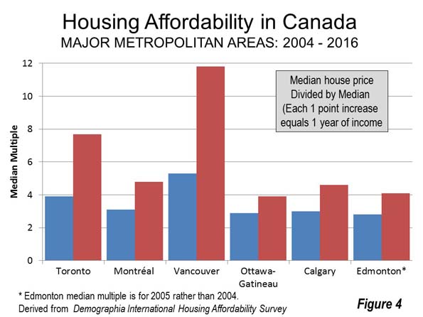
    Canada’s urban areas illustrate that density does not have to mean unaffordable housing. There has been some densification since 2000, but Canada’s urban areas were nearly as dense even then. For example, in the last 15 years, the completely developed city of Toronto, with all its new residential towers, has added only 10 percent to its population. Five of Canada’s six major metropolitan areas Toronto, Montréal, Ottawa-Gatineau, Calgary and Edmonton were affordable at the beginning of the new century, hovering around a median multiple 3.0.

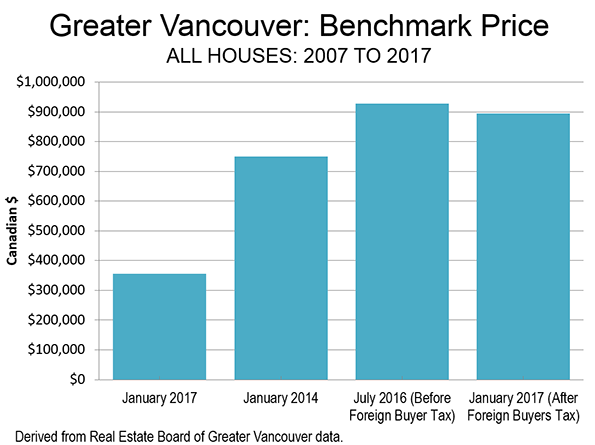
    All that has changed, however, with the imposition of urban growth boundaries and equivalent policies. Ailin He and I showed in a Frontier Centre study (Canada’s Middle Income Housing Affordability Crisis) that house prices had “exploded” relative to household incomes between 2000 and 2015. This cannot be attributed to the modestly higher densities. The big change took place in land use policy, with, for example, Toronto and Calgary adopting urban containment policy that has been strongly associated with the destruction of housing affordability. Residents of Vancouver  — an urban area widely praised among planners —  have been paying the price for urban containment for much longer (Figure 4).

    Canada’s experience up to the end of the 20th century proves that dense and affordable urban areas can be achieved. But since that time, as house prices have risen relative to incomes, Canada’s experience shows that all that can be reversed in an environment of binding urban containment policy.

    Note 1: Between 2011 and 2016, Canada’s urban areas increased more than 40 percent in population density, according to Statistics Canada data. This, however, was not a miracle of urban containment policy or smart growth, it was rather an improved method adopted by Statistics Canada for measuring urbanization. Urban areas are the "physical city," which unlike the metropolitan area has only urban land. Canada now calls its urban areas "population centres," having changed to the new label in 2011, when the United Kingdom labeled them "built up urban areas."

    In 2011 and before, the Census had used municipalities as building blocks for urban areas. Often, those municipalities included large swaths of rural land (as did Los Angeles until well into the 1950s). Now, the building blocks for urban areas in Canada are "blocks", the lowest enumeration geography of the Census (the same revision was implemented by the US Census in 2000). Under the old definition, Canada’s urban areas had a density of 1,180 per square kilometer (3,057 per square mile) in 2011. Now it is 1,698 per square kilometer (4,397 per square mile), a 44 percent increase.

    Note 2: The comparisons are between the 2016 Census of Canada data and the 2010 US Census data, since urban area (population centre) data is only developed in the censuses (the next US census will be in 2020). The list is developed from the 59 urban areas in Canada and the 499 in the United States with 50,000-plus residents in the last censuses.

    Note 3:  A recent article found Boston to be almost five times as dense as Houston. However, this was in municipal (inside the city limits) density. City limits are artificial, political constructs that have nothing to with the organic city (the physical city , also called urban area or the economic city, or the metropolitan area , which is the labor market).  The Houston urban area, with its reputation for "sprawl" is actually one-third denser (1150/2979 ) than Boston’s (856 /2,278). At the physical city level, the urban area is the best indication of urban density. Using metropolitan density as an indicator of urban density is nonsensical, since all metropolitan areas include substantial rural territory.

    Wendell Cox is principal of Demographia, an international public policy and demographics firm. He is a Senior Fellow of the Center for Opportunity Urbanism (US), Senior Fellow for Housing Affordability and Municipal Policy for the Frontier Centre for Public Policy (Canada), and a member of the Board of Advisors of the Center for Demographics and Policy at Chapman University (California). He is co-author of the “Demographia International Housing Affordability Survey” and author of “Demographia World Urban Areas” and “War on the Dream: How Anti-Sprawl Policy Threatens the Quality of Life.” He was appointed to three terms on the Los Angeles County Transportation Commission, where he served with the leading city and county leadership as the only non-elected member. He served as a visiting professor at the Conservatoire National des Arts et Metiers, a national university in Paris.

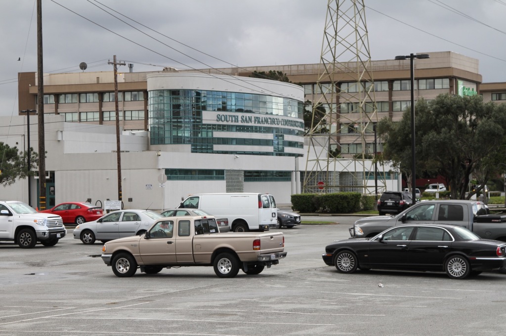
    Photo: Suburban density in Toronto (Markham) by IDuke – English Wikipedia, CC BY-SA 2.5

  • Is Climate Change Really the Cause of Mexico City’s Water Problems?

    A couple weeks ago the New York Times ran a gigantic front-page Sunday article by architecture critic Michael Kimmelman on Mexico City’s water crisis.

    This piece was billed as the first installment in a series on the effect of climate change on cities. Which is a head-scratcher, since Mexico City’s problems don’t seem to have anything to do with that.

    Mexico City is a megacity of 21.2 million people, making it roughly the size of greater New York. It’s also a mile and a half above sea level on a former lake bed in a valley among the surrounding mountains. So it’s at a significantly higher elevation than even Denver.

    This creates huge problems. A gigantic city has huge water needs. At high elevation, using a gravity feed for water is complicated to say the least. This necessitates costly pumping to delivery water from remote sources. The city is surrounded by mountains making even drainage complex. Much of the city’s water supply has come from its own ground water, and the city is sinking from the subsidence as a result of pumping.

    And of course Mexico and its capital are in the developing world, and so do not have the wealth to construct and maintain New York City style infrastructure.

    All of this is basically covered in the Kimmelman piece, which is good in many ways. But it’s not clear where climate change comes in. All of these problems would exist apart from any climate change. At best, he simply argues that climate change will make things worse, though without citing any real specifics. He only says:

    “It is a cycle made worse by climate change. More heat and drought mean more evaporation and yet more demand for water, adding pressure to tap distant reservoirs at staggering costs or further drain underground aquifers and hasten the city’s collapse.”

    Why in the world would the Times want to make this into a climate change story? It’s manifestly obvious from the article itself that the core water problems in Mexico City have nothing to do with climate change, but come from geography, size, and bad decision making.

    Trying to make it a climate change story only draws attention away from the need to make local changes to address the water situation. It also won’t convince anybody of anything. People who already believe in climate change don’t need any convincing. Those who don’t are never going to be convinced by this article. What’s the point?

    It seems to me that too many urbanist writers today simply can’t resist trying to make every single thing some manifestation of climate change. In that regard, they simply link more and more policy areas to something which is politically gridlocked in the United States. So what people do when they make things about climate change is to implicitly state that they don’t actually want to do anything about it.

    Many changes are eminently justifiable on their own merits. Bringing in climate changes only poisons the waters politically. And it’s a cop out. If you can’t make the case for, say, transit, without resorting to climate change, then your case is simply weak.

    When it comes to things like Mexico City’s water, where there’s a real problem and some action should be taken, better to avoid talking about climate change if you actually want to get anything done.

    Aaron M. Renn is a senior fellow at the Manhattan Institute, a contributing editor of City Journal, and an economic development columnist for Governing magazine. He focuses on ways to help America’s cities thrive in an ever more complex, competitive, globalized, and diverse twenty-first century. During Renn’s 15-year career in management and technology consulting, he was a partner at Accenture and held several technology strategy roles and directed multimillion-dollar global technology implementations. He has contributed to The Guardian, Forbes.com, and numerous other publications. Renn holds a B.S. from Indiana University, where he coauthored an early social-networking platform in 1991.

    Photo: Fidel Gonzalez [CC BY-SA 3.0 or GFDL], via Wikimedia Commons

  • A New Age of Progressive Suburbanism?

    We are living in a global suburban age… While statistics demonstrate that the amount of the world population in metropolitan areas is rapidly increasing, rarely is it understood that the bulk of this growth occurs in the suburbanized peripheries of cities. Domestically, over 69% of all U.S. residents live in suburban areas; internationally, many other developed countries are predominately suburban, while many developing countries are rapidly suburbanizing as well.”

    That’s not some anti-urban crackpot statement (as some inner urban elites might think) but from the introduction to a biennial theme of the MIT Center for Advanced Urbanism (USA). They understand that suburban and regional centres are not irrelevant for the future economy but highly important.  MIT are a pretty credible lot – hardly likely to pursue fringe urban planning or economic theories.

    In Australia, however, that message is not getting through. From the Prime Minister, down, there is a sense of irrational exuberance that the jobs of the future will mostly be concentrated in our CBDs and inner cities. Urban planning which supports increased concentration of employment through generous infrastructure allocations to inner urban areas is the manifestation of this inner urban obsession.  And while CBDs and inner urban areas are lavished with costly projects designed mainly to benefit the minority of people who work there, suburban and regional centres – where the majority live, work and play – have been largely left to fend for themselves.

    This process started in the late 1990s and early 2000s, notions about the “creative class” — many of which are being re-examined by author Richard Florida in a new book —   was a cause celebre amongst planning and government circles. It was widely argued that to attract the creative class of worker (synonymous with high skills and the new economy) cities needed to invest heavily in the quality of life in their downtowns. This was a precursor to the inner urban hipster, and, when real estate prices, rose their successors, the rise of the inner-city latte set.

    This thinking fit in well with two other trendy theories, New Urbanism and ‘Smart Growth’ (which redefined suburban progress as urban sprawl). The collective wisdom moved from supporting a growing suburban realm to one that disparaged it: the burbs were for bogans, the home of sprawl, “McMansions” full of low wage earning, culturally deficient and poorly educated masses, eating fast food diets and slurping sugar drinks. Inner cities by contrast were for educated, cultured and knowledgeable people – who had little need for suburban spaces or suburban habits but greater need for inner city waterfront cycle ways, museums, theatres and quality restaurants run by notable chefs. And, of course, lots of baristas. 

    Urban planning shifted quickly to a highly-regulated approach which promoted much higher densities of inner urban housing (and limits on outward expansion) because, after all, the inner city is where everyone in the future will want to live, right? The promises of these regional planning policies bordered on messianic. Take this example from the “Draft Metropolitan Strategy for Sydney to 2031” from the early 2000s:

    “A home I can afford. Great transport connections. More jobs closer to where I live. Shorter commutes. The right type of home for my family. A park for the kids. Local schools, shops and hospitals. Liveable neighbourhoods.”

    And what have we got thus? Some of the worst housing affordability in the world. Worsening congestion. Longer commutes. Limited housing choice, much of it not ideal for raising families.

    The ongoing policy focus and infrastructure obsession with centralisation is utterly at odds with economic and community signals. New economy industries in technical, scientific or professional services, or health and social care, have little interest in centralisation. Digital technology has broken that tyranny of distance. Undeterred though, we continue to watch as political and industry leaders promote costly infrastructure projects that enhance and support further centralised employment and a concentration of amenity in inner urban cores enjoyed by a privileged, mostly childless minority.

    For the record, the proportion of metropolitan wide jobs in the inner cities of Melbourne, Sydney and Brisbane was 11%, 13% and 12% respectively at the last census.  The reality remains that in our metropolitan centres, most people both live and work outside inner city bubbles of privilege. 

    The penny is finally dropping in some minds. Former Victorian Planning Minister, Matthew Guy (now Opposition Leader) once extolled the virtues of high density inner urban development. Looks like he has had a Damascus moment, commenting in The Australian (March 1, 2017) that: “Victoria is becoming a great, heaving, unsustainable mess. The whole of Victoria is just becoming an offshoot of Melbourne.”

    The emphasis on centralisation of jobs, housing and supportive infrastructure makes little sense in a country with such large land masses and capacity for expansion. Not only that, but the economic winds – enabled by rapid expansion of disruptive technology – are blowing the other way. Suburban and regional centres, long disparaged by the cognoscenti should instead be looked on as part of the solution to economic expansion and development. Where once we promoted urban renewal, we now need to turn our minds to suburban and regional renewal. We need to identify the critical infrastructure constraints of suburban and regional business centres and remedy them to encourage accelerated development of employment opportunities across the board.

    In a bid to put some balance into the discussions about urban development and growth, a Suburban Alliance (www.suburbanalliance.com.au) has been formed in Australia – with the intention of supporting research projects into the nature and needs of the suburban economy, and to use these as a platform for well-informed policy advocacy. Wish us luck. The initial focus starts in Brisbane but if the idea finds support, we’d like to see this expand to cover all major urban and regional centres. 

    The more supporters we can muster the sooner this absurd preoccupation with all things inner city can begin to be balanced with a better understanding of the important role played by suburban and regional business centres and why these are part of the solution to enhanced economic opportunity.

    Ross Elliott has more than twenty years experience in property and public policy. His past roles have included stints in urban economics, national and state roles with the Property Council, and in destination marketing. He has written extensively on a range of public policy issues centering around urban issues, and continues to maintain his recreational interest in public policy through ongoing contributions such as this or via his monthly blog, The Pulse.

    Photo: Photograph by Gnangarra [CC BY 2.5 au], via Wikimedia Commons

  • Los Angeles Traffic: Likely To Worsen with Higher Densities

    A few recent days driving the Los Angeles freeways impressed me with how different they are from in most other places in the country. The intensity of the traffic is astounding. Even on the weekend, travel over Sepulveda Pass on the San Diego Freeway (I-405) was highly congested. Traffic really never stopped, but frustratingly inched along for parts of the way and approached 60 miles per hour on other parts. A Saturday trip I feared might take an hour and a half was completed from Simi Valley in less than 60 minutes. Caltrans and the local officials do an admirable job of keeping the traffic moving, which was obvious from the only slight delay near Sherman Way caused by an incident that required a fire truck.

    Traffic Per Lane Mile

    The latest Federal Highway Administration data indicates that nearly 23,000 cars are handled by each freeway lane on the average day. Among the larger urban areas, only San Jose and close-by Riverside-San Bernardino have a volume of more than 20,000 daily.

    The freeway lane volume in Los Angeles is up from 16,500 cars per lane mile in the early 1980s,  a more 37 percent increase in traffic (Figure 1). This is not surprising, because the urban area, which stretches from the San Fernando Valley to Pomona and Orange County to San Clemente has added almost the same percentage of residents. The city of Los Angeles itself, which covers virtually the same area as it did more than three decades ago has become significantly more dense, also adding about one third to its population.

    At the same time, public policy in California is calling for significant urban densification that will put an even greater strain on the roadway network. Any assumption that a more dense Los Angeles will be anything less than an even more horrific traffic environment is simply folly.

    Billions Spent on Rail: Yet Traffic is Much Worse

    Some, including me while I was on the Los Angeles County Transportation Commission, believe (or in my case “believed”) that an expansion of transit — especially adding urban rail service, would relieve traffic congestion. Los Angeles has now had nearly three decades of experience with that strategy. Yet, traffic has only become more intense.

    Indeed, despite the addition of a substantial urban rail system in Los Angeles County has been accompanied by a general decline in transit ridership on the Metropolitan Transportation Authority services compared to predecessor services operated by the Southern California Rapid Transit District in 1985. In 2016, ridership was even lower than the year before, despite the extensions of rail service to Santa Monica on the Expo Line and to Azusa on the Gold Line.

    Even work trip ridership, which transit serves best, is down. In 1980, transit’s market share was 7.0 percent in Los Angeles County. By 2015, transit’s market share had fallen slightly to 6.8 percent. Meanwhile, driving alone expanded significantly from 68.7 percent in 1980 to 73.0 percent in 2015. Working at home increased from 1.5 percent in 1980 to 5.1 percent in 2015 (Figure 2).

    Why Rail has Not Attracted Drivers

    There are two principal reasons the transit has not been able to attract drivers out of their cars and reduce freeway volumes. The first is that, for the most part, you cannot get from here to there on transit. That is, most jobs and places people are traveling cannot be conveniently accessed by transit. The University of Minnesota Accessibility Laboratory has found that 43.3 percent of jobs in the Los Angeles metropolitan area can be reached by car within 30 minutes. By contrast. Only 0.7 percent of jobs can be reached by transit within 30 minutes. In other words, the accessibility provided by cars is much greater than that of transit. For every job that can be reached by transit within 30 minutes, nearly 60 times as many jobs can be reached by car (Figure 3).

    Even where jobs can be reached by transit, it takes far longer. According to the latest American Community Survey data, the average one way work trip travel time for people driving alone in the Los Angeles metropolitan area is 27.9 minutes. By contrast, the average Metro Rail rider takes 52.2 minutes to reach work (Figure 4). It is not hard to imagine why people have not traded in their faster car travel times for slower trips on transit. Excess travel time, regardless of how traveled, takes away from other necessary activities and recreation.

    Further, with all the talk about “urban villages,” with the expected improved jobs housing balance, it is well to recognize such an achievement would be unprecedented. As former principal planner of the World Bank Alain Bertaud put it: “…the urban village "model does not exist in the real world because it contradicts the economic justification of large cities: the efficiency of large labor markets." The cold water of reality is that "… the urban village model exists only in the mind of urban planners."

    Of course, talk of people living near where they work is dubious, particularly in a metropolitan area where housing affordability  is challenging both for the vast majority of renters and potential buyers. When does anyone think this will happen? In “this life” or maybe in the “life to come?”

    The bottom line, unfortunate and politically incorrect as it is, is that transit simply cannot reduce traffic congestion. Some other strategy needs to be deployed.

    Prognosis: More Density, More Traffic

    Los Angeles traffic is likely to get much worse, especially if the development becomes substantially denser. All of the 12 world urban areas in the recent Tom Tom Congestion Index that have worse traffic than Los Angeles are denser. This is consistent with the international evidence that shows a strong association between higher densities, greater traffic congestion and lengthened work trip travel times. The experience in Los Angeles shows the same thing.

    Wendell Cox is principal of Demographia, an international public policy and demographics firm. He is a Senior Fellow of the Center for Opportunity Urbanism (US), Senior Fellow for Housing Affordability and Municipal Policy for the Frontier Centre for Public Policy (Canada), and a member of the Board of Advisors of the Center for Demographics and Policy at Chapman University (California). He is co-author of the "Demographia International Housing Affordability Survey" and author of "Demographia World Urban Areas" and "War on the Dream: How Anti-Sprawl Policy Threatens the Quality of Life." He was appointed to three terms on the Los Angeles County Transportation Commission, where he served with the leading city and county leadership as the only non-elected member. He served as a visiting professor at the Conservatoire National des Arts et Metiers, a national university in Paris.

    Photo: North on the 110 Toward Downtown, AM Peak (by author)

  • Vancouverizing Seattle?

    A recent Wall Street Journal article (“For Chinese buyers, Seattle is the new Vancouver”) reported that Seattle was replacing Vancouver as the most popular destination for Chinese buyers in North America. For years, there has been considerable concern about foreign investment in the Vancouver housing market, especially Chinese investment. This   demand is widely believed to have driven Vancouver house prices “through the roof.” In response, the British Columbia government recently imposed a 15 percent foreign buyers tax that has had the impact of significantly reducing new foreign investment in Vancouver’s housing market.

    Yet the impact of the tax has still been muted. Houses remain just about as unaffordable as before. The Real Estate Board of Greater Vancouver benchmark price has dropped less than four percent from six months ago, before the foreign buyers tax was imposed. This compares to an 80 percent increase over the last 10 years and 47 percent increase over just the last three years (Figure).

    Clearly there is something other than Chinese investment driving up Vancouver house prices. Since 2004, Vancouver’s median multiple (median house price divided by median household income) has risen from 5.3 to 11.8. This means that that the median house has increased in price more than six times the annual median household income.

    The primary cause of Vancouver’s difficulties is a rigged housing market. For decades, Vancouver has had some of the strongest urban containment policy in the world. Regional land-use authorities have prohibited  housing development from being built on a large agricultural reserve. This land is hardly needed for such use in a nation that has increased its gross agricultural output more than 150 percent since 1961, while reducing its land in farms by three times as many acres as is occupied by all urban settlements combined, according to the 2016 Canadian census. Of course, urban containment restrictions on new housing have driven up house prices, just as Middle East oil supply reductions used to drive up gasoline prices, before the recent supply increases from Canadian and US oil production.

    Vancouver has literally become the third most unaffordable city (metropolitan area) in the nine nations covered by the Demographia International Housing Affordability Survey. This makes a mockery of the Vancouver’s frequent citation as one of the most livable cities in the world. The first principle of livability is affordability — you cannot live where you cannot afford. Most young families of normal economic means cannot hope to ever buy a modest detached house with a yard as their parents or grandparents did decades ago in the Vancouver area. Only Hong Kong and Sydney are less affordable.

    In a recent column (“Not much can or will be done to make Vancouver housing more affordable”) by Gordon Clark in The Province (Vancouver newspaper) describes how things have changed, in a story similar to what you will hear in Sydney, San Francisco and others of the world’s most unaffordable cities. In 1941, his postal supervisor grandfather purchased a house on Oak Street (a main central arterial leading toward downtown) for 1.5 years of income. In 1979 his teacher mother purchased a house in the city of Vancouver for 2.5 times her income. Now with houses costing nearly 12 times incomes, Clark regretfully concludes that nothing can be done: “because the solutions are unacceptable to most people.”

    This illustrates what is perhaps the most powerful characteristic of urban containment regulation — that it creates a strong lobby of support among those who have seen their house values irrationally escalate as a result of unwise government policy. In this environment, public officials simply wring their hands, decry the problem and implement nothing of substance to change the essentially flawed policies. 

    With this rigged market, it should not be surprising that people with money from outside Vancouver, and abroad, would seek to buy houses in Vancouver. After all, the policies all but guaranteed strong returns to anyone with enough capital to enter the market.   It is as if a “Speculators Welcome” banner has been hung from Lion’s Gate Bridge. Not so welcome are those middle-income households being driven out of the market

    Lessons for Seattle

    All of this is a cautionary tale for the Seattle metropolitan area, which also has urban containment policy, but of more recent vintage. Just 140 miles or 225 kilometers south of Vancouver, Seattle’s has housing affordability that already as bad as Vancouver’s  only 12 years ago.

    Seattle has a severely unaffordable median multiple of 5.5, slightly worse than Vancouver’s 5.3 in 2004. In the late 1980s, before Seattle imposed its metropolitan- urban containment policy, the median multiple was as low as 2.4 (Table). Today, a Seattle household with the median income must pay three additional years of income for the median priced house.

    Rising housing demand with severely constricted supply is associated with higher house prices compared to incomes. In this regard, Seattle has multiple risks, from households escaping California to escape from the even higher prices, Seattle is a bargain compared to the “dogs breakfast” of unaffordable housing associated with California where median multiples now exceed 8.0 in all of the major coastal metropolitan areas (Los Angeles, San Francisco, San Diego and San Jose). Prices are so high in California that a seller can buy a comparable house in Seattle for hundreds of thousands less. There may not be as much sun in Seattle, but there’s plenty of money left over for umbrellas and other goods and services.

    Now the pressure is likely to increase as foreign investors who shop the world for rigged housing markets promise quick profits now turn their attention to the Puget Sound. In this environment, it would not be surprising for additional serious house price escalation to be in the offing, and Seattle to indeed become the new Vancouver in the next decade or two.

    Given these forces, we can expect Seattle housing prices   will continue to increase disproportionately to incomes unless there is land use policy reform. Sufficient supply must be allowed on greenfield land to keep house prices from rising farther. And “building to the sky”— which is very expensive and not very family friendly —  is not likely to restore housing affordability in Seattle any more than it has anywhere else. For example, the Manhattanization of central Toronto, with its many new residential towers, has not prevented its median multiple from doubling from 3.9 to 7.7 in the last 12 years. Nor has it prevented a far less obvious (at least to the press) 80 percent share of population growth to be in the suburbs between 2011 and 2016.

    Lost in all of this are ordinary middle and working class people, who routinely take a back seat in public policy to planning obsessions over urban form, and a “sense of place.” Middle-income households are far more in need of a “decent place” to live at a reasonable price. Architectural marvels or sleek streetscapes are no substitute. The issue is not ideological, it is rather practical and human. Nor is it about property rights, or free markets. The issue is that people are being denied the housing they desire by urban containment policy and its distorted priorities. As Paul Cheshire, Max Nathan and Henry G. Overman of the London School of Economics have pointed out, “people rather than places” should be the focus of urban policy.

    It is ironic that progressive metropolitan areas, like Vancouver, where inclusionary zoning drip feeds housing to lower income households, have become, large exclusionary zones where average income households cannot afford houses. Seattle is headed down the same path.  Soon it may be time to hang a “Speculators Welcome” banner from the Space Needle.

    Photograph: Downtown Seattle (by author)            

    Wendell Cox is principal of Demographia, an international public policy and demographics firm. He is a Senior Fellow of the Center for Opportunity Urbanism (US), Senior Fellow for Housing Affordability and Municipal Policy for the Frontier Centre for Public Policy (Canada), and a member of the Board of Advisors of the Center for Demographics and Policy at Chapman University (California). He is co-author of the "Demographia International Housing Affordability Survey" and author of "Demographia World Urban Areas" and "War on the Dream: How Anti-Sprawl Policy Threatens the Quality of Life." He was appointed to three terms on the Los Angeles County Transportation Commission, where he served with the leading city and county leadership as the only non-elected member. He served as a visiting professor at the Conservatoire National des Arts et Metiers, a national university in Paris.

  • Re-inhabitation of Small Town America

    My friend Kirsten Dirksen at faircompanies.com recently posted a new video about Water Valley, Mississippi. It demonstrates that there are plenty of great compact mixed use walkable neighborhoods out there that can be re-inhabited. Building anything of this kind from scratch is theoretically possible, but it almost never happens due to endless zoning regulations, building codes, and cultural inertia. Water Valley is lucky in the sense that it’s just down the road from a prestigious university. That gives the town an advantage over similar places too far afield from money and culture. But it shows what’s possible under the right circumstances.

    Video by Kirsten Dirksen at faircompanies.com

    John Sanphillippo lives in San Francisco and blogs about urbanism, adaptation, and resilience at granolashotgun.com. He’s a member of the Congress for New Urbanism, films videos for faircompanies.com, and is a regular contributor to Strongtowns.org. He earns his living by buying, renovating, and renting undervalued properties in places that have good long term prospects. He is a graduate of Rutgers University.

  • King Tide

    10,000 years ago San Francisco Bay was a dry grassy valley populated by elephants, zebras, and camels. The planet was significantly cooler and dryer back then. Sea level was lower since glaciers in the north pulled water out of the oceans. The bay isn’t that deep so a relatively small change in sea level pushed the coastline out by twelve miles from its present location. Further back in pre-history when the earth was warmer than today sea level was higher. The hills of San Francisco were small islands off the coast of ancient California.

    screen-shot-2017-01-15-at-5-10-06-am

    screen-shot-2017-01-15-at-5-10-51-am

    These cycles play out on a scale we humans can’t perceive in our daily lives. You can think of this process as a larger version of the tides that play out over thousands of years instead of twice a day. There’s absolutely no need to debate human induced climate change. The climate changes all the time with or without us. The real question is how we will adapt over time.

    screen-shot-2017-01-15-at-9-19-21-pm

    screen-shot-2017-01-15-at-9-20-26-pm

    screen-shot-2017-01-15-at-9-21-47-pm

    screen-shot-2017-01-15-at-9-22-13-pm

    In the last century the majority of what was once low lying wetlands around the bay were filled and built upon. Airports, shipping terminals, oil refineries, housing developments, and industrial parks are sitting on landfill just slightly above water.

    screen-shot-2017-01-15-at-2-27-45-am

    screen-shot-2017-01-15-at-2-26-35-am

    screen-shot-2017-01-15-at-2-26-48-am

    We just experienced a king tide. This is a naturally occurring cyclical event that happens whenever the earth, moon, and sun line up in a particular way to create a tide that’s about seven feet higher than usual. In this part of the world king tides tend to arrive a few times a year alongside heavy winter rains. The result is a submerged landscape that at a normal high tide in summer is actually dry land.

    screen-shot-2017-01-15-at-3-33-51-am

    screen-shot-2017-01-15-at-3-45-44-am

    A significant amount of territory would be underwater in a king tide if it weren’t for extensive levees, drainage ditches, canals, and pumping stations that actively manage the hydrology of the built environment.

    screen-shot-2017-01-15-at-4-11-10-am

    screen-shot-2017-01-15-at-4-00-17-am

    screen-shot-2017-01-15-at-4-38-15-am

    screen-shot-2017-01-15-at-4-38-33-am

    So far the engineered solutions are working to plan. But this stuff is expensive to build and maintain. If we skimp or take our eyes off the ball there’s a risk of a breach that would do serious damage to the affected areas. This is California’s version of New Orleans with the added feature of seismic activity to complicate matters.

    screen-shot-2017-01-14-at-7-31-19-pm

    screen-shot-2017-01-15-at-1-27-24-am

    screen-shot-2017-01-15-at-1-28-46-am

    screen-shot-2017-01-15-at-1-28-18-am

    screen-shot-2017-01-15-at-1-29-36-am

    Last summer I was exploring the semi industrial neighborhoods around the airport just south of the city and found myself having a conversation with a hotel manager.

    screen-shot-2017-01-14-at-5-56-28-pm

    screen-shot-2017-01-14-at-5-53-58-pm

    screen-shot-2017-01-14-at-5-48-19-pm

    screen-shot-2017-01-14-at-5-55-40-pm

    Even during ordinary high tides the water level of the canal is about the same as the parking lot. So whenever it rains the drainage system that normally pulls water away from the land works in reverse and canal water is pushed up onto the surface.

    screen-shot-2017-01-14-at-6-40-56-pm

    screen-shot-2017-01-14-at-5-53-32-pm

    screen-shot-2017-01-14-at-5-52-55-pm

    screen-shot-2017-01-14-at-5-53-10-pm

    What’s the difference between a hotel room that remains completely dry vs. a hotel room that has just one inch of standing water on the floor? That’s the difference between $100 a night and $0 per night.

    screen-shot-2017-01-15-at-1-06-27-pm

    screen-shot-2017-01-15-at-1-07-45-pm

    screen-shot-2017-01-15-at-1-07-01-pm

    The management has long responded to the situation by not renting ground floor rooms during the rainy season. That constitutes a seasonal operating loss since any hotel that falls below a 60% occupancy rate loses money. But there isn’t much that can be done. The rooms on the lower level are being renovated so that once the weather clears up the hard surfaces can be thoroughly cleaned and aired out and put back on the market without incident.

    screen-shot-2017-01-15-at-1-36-48-am

    screen-shot-2017-01-15-at-10-37-11-pm

    screen-shot-2017-01-15-at-10-37-39-pm

    Warehouses and industrial sheds in the area have a similar set of challenges. Who exactly wants to store or manufacture things in a facility that gets wet whenever it rains at high tide?

    screen-shot-2017-01-15-at-1-05-37-pm

    screen-shot-2017-01-14-at-7-29-52-pm

    screen-shot-2017-01-14-at-7-29-36-pm

    I was curious why such valuable waterfront land wasn’t redeveloped with new construction that was built with rising tides and earthquakes in mind. Wasn’t the canal a natural feature that could be capitalized upon as a major amenity? Wouldn’t people pay extra to stay at a fancy hotel or live along a landscaped promenade with cafes and shops? It could be really nice, and the real estate market would certainly be able to absorb the required price point. I was told the hotel owner had asked for permission to redevelop the site as a retirement village. Local regulators denied the applications. The city insists that the property remain as it is.

    Over the years I’ve had more than one mayor or city official in different parts of the country explain that each new resident costs the city money in services and infrastructure. What cities desperately need is tax revenue. That’s why we see a proliferation of casinos, premium outlet malls, entertainment complexes, and technology parks. A half assed soggy hotel is better for the city’s bottom line than anything that will burden the municipality with needy residents.

    screen-shot-2017-01-15-at-4-13-00-am

    screen-shot-2017-01-15-at-4-12-28-am

    screen-shot-2017-01-15-at-4-11-57-am

    screen-shot-2017-01-15-at-4-15-58-am

    screen-shot-2017-01-15-at-4-15-23-am

    In the short term there are all manner of temporary quick fixes that can keep this system going. But over the long haul there are only two possible trajectories for these places. One is for huge sums of public money to be spent defending private property. The other is that the structures that currently occupy vulnerable positions will lose value, be abandoned, and gradually slip under the tide. Downtown San Francisco is likely to find the funds to keep back the waves. Will taxpayers really be willing to fortify the old Taco Bell and aging suburban big box store? Toss in an earthquake or two and things could get really interesting very fast. Happenstance is the polite politically neutral term for this kind of triage.

    John Sanphillippo lives in San Francisco and blogs about urbanism, adaptation, and resilience at granolashotgun.com. He’s a member of the Congress for New Urbanism, films videos for faircompanies.com, and is a regular contributor to Strongtowns.org. He earns his living by buying, renovating, and renting undervalued properties in places that have good long term prospects. He is a graduate of Rutgers University.

    All photos by Johnny Sanphillippo

  • Are America’s Cities Doomed to Go Bankrupt?

    I’m a fan of Strong Towns and share their thesis that the biggest sustainability problem with much of suburbia is its financial sustainability.

    recent article there about Lafayette, Louisiana has been making the rounds. That city’s public works director made some estimates of infrastructure maintenance costs and which parts of the city turned a “profit” from taxes and which were losses. Here’s their profit and loss map.

    The obvious conclusion that we are supposed to draw is that dense, compact, traditional urban development is profitable and good, but low density sprawl is a money loser and bad.

    There’s some truth in this, but taking that simplistic view can give a misleading impression. For example, let’s consider why high density central business districts tend to have such density of development and high property values per acre (and thus taxes). It’s obvious that these districts derive a great part of their value from the overall scale of the community, i.e., sprawl.

    Let’s do a quick thought experiment. Lower Manhattan below 59th St. is certainly incredible valuable property. However, if the rest of the metro area were some how chopped away leaving only this super-valuable part, how much value would that land retain? In part, Manhattan is valuable because it’s the center of a vast megacity region where tremendous amounts of human capital that lives in dispersed communities can be concentrated in a small area for commercial purposes.

    This article says that only about five cities in America don’t suffer from a fatally flawed financial model. I seem to recall that elsewhere they said NYC and SF are the only two cities that can survive in the long run financially.

    But it wasn’t that long ago that NYC nearly went bankrupt and had to be rescued. A recent study just said that its structural finances are the second worst of any major city in the country, primarily because of its gigantic liability for retiree health care. NYC looks good now because its economy has been booming. Let’s see how it does it a major downturn, particularly without a strong fiscal hand like Bloomberg at the tiller.

    San Francisco is unaffordable to all but very high income residents. It’s a de facto gated community. It may well be that pricing everybody but the rich out is a viable strategy for financial sustainability, but that’s obviously a path foreclosed to most places, even if they wanted to try it.

    We also need to consider that there’s infrastructure we have maintained. By and large our telecommunications infrastructure and electricity infrastructure are in very good shape, for example.  For telecom especially we’ve made vast investments to not only maintain, but dramatically upgrade our infrastructure. How did we manage to pull that off if it’s financially impossible to maintain and upgrade infrastructure? What lessons could we learn from that?

    In short, I agree with the general Strong Towns thesis that we need to look at the long run “total cost of ownership” of sprawl. In many cases, the math just doesn’t add up and some cities are in an infrastructure hole so deep they’re unlikely ever to get out. But they are overstating their case here.

    Aaron M. Renn is a senior fellow at the Manhattan Institute, a contributing editor of City Journal, and an economic development columnist for Governing magazine. He focuses on ways to help America’s cities thrive in an ever more complex, competitive, globalized, and diverse twenty-first century. During Renn’s 15-year career in management and technology consulting, he was a partner at Accenture and held several technology strategy roles and directed multimillion-dollar global technology implementations. He has contributed to The Guardian, Forbes.com, and numerous other publications. Renn holds a B.S. from Indiana University, where he coauthored an early social-networking platform in 1991.

    Photo "Downtown Lafayette, Louisiana" by Patriarca12 (Own work) [CC BY 3.0], via Wikimedia Commons