Category: planning

  • Suburban Design: Square Peg In A Round Hole

    Remember that Fisher Price toy – “Baby’s First Blocks”? It was supposed to teach us one of life’s first lessons: Place a square shape in a square hole, and a round shape in a round hole. We’re supposed to understand this idea before we learn to say our first words, or to walk. Yet in the development of our neighborhoods, we have put that square shape into every hole, no matter what the shape of that hole.

    In past centuries land was primarily developed with one pattern – the grid — because it was simple to calculate the geometry and stake out in the field. No matter what you have read about the “town square” and the advantages of the “grid pattern”, the reason for the grid was simply that it sidestepped the painstaking task of manually calculating the land development plat when curves were involved. Forested areas were routinely clear-cut, and swamps (today’s wetlands) were filled in. Those were the days during which development was straight-forward and simple: develop land while destroying what nature provided on the soil. Natural topography, which is certainly not based upon the grid, was bulldozed into oblivion.

    In the 1960’s, newer forms of site design became commonplace, primarily in the exploding suburban landscape that rose after urban-core riots fueled what was then known as “White Flight”. This newer form of design introduced more curved patterns. Unlike the grid, the occasional curve broke up the monotony, and submitted site plans began to look more interesting. These new patterns were the start of a desire to follow the natural shape of the terrain.

    But in the 1960s we did not have an awareness of the environmental damage of development that we posses today. As automation in computations, drafting, and land surveying technology began to reduce the workload of non-gridded designs, the curved pattern became more commonplace. This transition is easily seen by visiting any city’s land records and looking at the changes in land development patterns of recorded plats since World War II.

    For decades, the curved patterns were designed by individuals who concentrated on density goals by squeezing every hundredth of a foot allowed by ordinance. Curved streets conform to the random contours of nature much better than the grid, and the curved pattern, if correctly designed, can be extremely efficient while delivering connectivity for vehicles and pedestrians. That is, if the land planner knows how to design these systems. But patterns that would harness any delivered vehicular and pedestrian connectivity were not part of the plan. Without concentrating on harnessing the curved patterns to create functional traffic systems, so-called “land planners” — and anyone can still become a land planner simply by adding the term ‘land planning’ to their business card — provided plenty of ammunition to the New Urbanism movement’s attacks on curved design.

    In any case, with the use of curved patterns land development broke away from sole use of the monolithic square shape, and introduced two new primary shapes: An inner pie shaped lot and an outer pie shaped lot. For more than a half century, these three basic shapes have defined the majority of the growth pattern for American development.

    These three basic shapes have been the foundation on which we have built millions upon millions of new homes. We have been placing that square shaped home in the triangular hole as if one of the first lessons we were taught was meaningless. Those toy blocks were supposed to teach us to take advantage of the shapes in life that we are offered. Apparently the architectural community, as well as the building industry, ignored this opportunity, until now.

    Home builders large and small have used the same basic shape, as if all lots were only rectangular. Even homes that have garage snouts and are often anything but rectangular in shape are set by civil engineers with a house “pad” that is based on the square. I’m pretty sure most of these engineers were brought up with the Baby’s First Blocks, or something similar. Forcing a square shape into a triangle shape results in a bigger triangle than need be, or making the square much smaller than necessary. In other words, we have built a quite inefficient world for over half a century.

    In an effort to create a more sustainable world, we are developing new methods to design neighborhoods. Part of the effort to eliminate the tremendous waste in land development has been to reassess architecture as part of the overall function of the neighborhood. This became much more critical as we developed Performance Planning System, which was created to teach sustainable development design methods. It quickly became apparent that there was a tremendous void in the opportunities to incorporate new forms of architecture, especially in developments with curved patterns.

    The square home that fits on the square lot does not offer much real opportunity for change. But the other two basic shapes invite new efficiency and value to the home buyer, critical in this down housing market. Homes that are shaped to fit on the inside of the curve can be wider in the front…much wider. This results in a home that does not have to be as deep, essentially making the rear area useable as well because of extra rear yard depth, while providing the same useable square footage. The extra width makes the garage less prominent, and creates much more viewable area from within the home that looks out on the larger rear yard and the streetscape. The home that’s wider in the front allows a bigger porch area and greater opportunity to tie living areas to the street. Less of the side of the home is exposed, and the streetscape becomes more attractive, enhancing that all-important curb appeal.

    The outer side of a curved shape is the opposite pie shape. In this case we can create a stronger tie to the larger rear yard (the outer curves have larger rear yards than a rectangular lot). Like the inner pie, there is more width opportunity to create a home that maintains a target square footage, yet is less deep, again creating an ever larger useable rear yard.

    Perhaps even more important is that we can use these new patterns either to make larger homes, to create larger, more useable yards, or to create non-rectangular pad shapes that adhere to the letter of the law (ordinance regulations) while gaining density and reducing neighborhood sprawl. Actually we can easily accomplish all three!

    So what do the home builders think? In this down economy there is little opportunity to for trends to develop, but in almost all cases where we have promoted this idea builders have embraced it. These developers have included one of the largest home builders in North America, and one of the most respected in Texas.

    The amount of waste we can eliminate by using the lessons that were supposed to be taught with our First Blocks is enormous. And it comes just in time to give builders that extra edge in today’s tough market.

    Rick Harrison is President of Rick Harrison Site Design Studio and Neighborhood Innovations, LLC. He is author of Prefurbia: Reinventing The Suburbs From Disdainable To Sustainable and creator of Performance Planning System. His websites are rhsdplanning.com and performanceplanningsystem.com.

  • Eminent Domain as Central Planning

    Free markets are out of vogue. The unfortunate lesson that policymakers have learned over the past two years is that a big, brainy government that supposedly creates jobs is superior to irrational, faceless markets that just create catastrophic errors. So Washington has seized on the financial and economic crises to enlarge its role in managing the economy—controlling the insurance giant AIG, for example, and trying to maintain high housing prices through tax credits and “mortgage modification” programs.

    But when it comes to central economic planning, New York City and State are way ahead of the feds. Empire State politicians from both parties already believe that it’s their responsibility to replace people and businesses in allocating the economy’s resources. They’re even confident that their duty to design a perfect economy trumps their constituents’ right to hold private property. Three current cases of eminent-domain abuse in New York show how serious they are—and how much damage such government intrusiveness can wreak.

    Brooklyn’s Prospect Heights, industrial and forlorn for much of the late twentieth century, was looking better by 2003. Government was doing its proper job: crime was down, and the public-transit commute to midtown Manhattan, where many Brooklynites worked, was just 25 minutes. That meant that the private sector could do its job, too, rejuvenating the neighborhood after urban decay. Developers had bought 1920s-era factories and warehouses and converted them into condos for buyers like Daniel Goldstein, who paid $590,000 for a place in a former dry-goods warehouse in 2003. These new residents weren’t put off by the Metropolitan Transportation Authority’s railyards nearby, and they liked the hardwood floors and airy views typical of such refurbished buildings. They also settled in alongside longtime residents in little houses on quiet streets. Wealthier newcomers joined regulars at Freddy’s, a bar that predated Prohibition. Small businesses continued to employ skilled laborers in low-rise industrial buildings.

    But Prospect Heights interested another investor: developer Bruce Ratner, who thought that the area would be perfect for high-rise apartments and office towers. Ratner didn’t want to do the piecemeal work of cajoling private owners into selling their properties, however. Instead, he appealed to the central-planning instincts of New York’s political class. Use the state’s power to seize the private property around the railyards, he told Governor George Pataki, Mayor Michael Bloomberg, and Brooklyn borough president Marty Markowitz. Transfer me the property, and let me buy the railyards themselves below the market price. I’ll build my development, Atlantic Yards, around a world-class basketball arena.

    New York, in short, would give Ratner an unfair advantage, and he would return some of the profits reaped from that advantage by creating the “economic benefits” favored by the planning classes. Architecture critics loved Frank Gehry’s design for the arena. Race activist Al Sharpton loved the promise of thousands of minority jobs. The Association of Community Organizations for Reform Now (Acorn) loved the prospect of administering the more than 2,000 units of “affordable” housing planned for the development, as well as the $1.5 million in loans and grants that Ratner gave it outright. When the state held public hearings in 2006 to decide whether to approve Atlantic Yards, hundreds of supplicants, hoping for a good job or a cheap apartment, easily drowned out the voices of people like Goldstein, who wanted nothing from the government except the right to keep their homes.

    Can New York legally seize private property and transfer it to a developer purely for economic development? The Fifth Amendment to the U.S. Constitution allows the government to take property for a “public use,” long understood to mean such things as roads and railways, so long as it makes “just compensation” for them. Starting around the 1930s, a number of court cases began to broaden “public use” to include more nebulous “public purposes,” such as slum clearance. And in 2005, in Kelo v. New London, the Supreme Court decided that these “public purposes” could even include economic development. But New York’s constitution theoretically holds the state to a higher standard. In 1967, Empire State voters voted not to add a “public purpose” clause to their constitution, preferring to stick with the stricter requirement of “public use.”

    The state hasn’t let this inconvenience derail its plans for Prospect Heights, however. For seven decades, courts have let New York seize and demolish slum housing if it’s blighted—which New York State defines as “substandard” and “unsanitary.” So the Urban Development Corporation (UDC), a public entity of New York State, decided that the “public use” of Atlantic Yards would be blight removal. The city had already designated part of the neighborhood as “blighted” 40 years earlier, long before its resurgence. As for the rest, the UDC commissioned consultants—previously employed by Ratner—who soon returned the requisite blight finding.

    But wait, you say: people don’t buy half-million-dollar apartments in “substandard” or “unsanitary” neighborhoods. You’re right; that’s why the consultants had to stretch. In the 1930s, as Goldstein’s attorney, Matthew Brinckerhoff, pointed out, “substandard” and “unsanitary” meant “families and children dying from rampant fires and pestilence” in tuberculosis-ridden firetraps. In 2006, by contrast, the UDC’s consultants found “substandard” conditions in isolated graffiti, cracked sidewalks, and “underutilization”—that is, when property owners weren’t using their land to generate the social and economic benefits that the government desired.

    In New York, this creative definition of blight is the new central-planning model. Consultants have also cited “underutilization” in West Harlem, where the city’s Economic Development Corporation wants to take land from private owners and hand it to Columbia University for an expansion project. Says Norman Siegel, who represents the owners: “A private property owner has the right to determine the best productive use of his property. It’s not a right to be ceded to any government.”

    And in Queens, the Bloomberg administration is preparing a similar argument to grab swaths of Willets Point, an area adjacent to Citi Field that’s populated with auto-repair shops. The city’s recent “request for qualifications” from would-be developers drew a sharp response from the people who owned the land: “We . . . hold the most significant qualification of all: we own the properties. We are motivated to improve and use our own properties, consistent with the American free market system. We would have done so in spectacular fashion already, had the city upheld its end of the bargain by providing our neighborhood with essential services and infrastructure.” Instead, the city has done the opposite, letting streets disintegrate into ditches to bolster its blight finding. The perversity is astonishing: rather than doing its own job of maintaining public infrastructure and public safety, the government wants to do the private sector’s job—and is going about it by starving that private sector of public resources.

    Property owners have looked to the judiciary to check the overweening grasp of the legislative and executive branches. But courts can be wrong for longer than it takes to save a neighborhood. In Brooklyn, Goldstein and his neighbors have lost their lawsuits—most recently, in New York’s highest court, the court of appeals. In November, the court decided 6–1 that “all that is at issue is a reasonable difference of opinion as to whether the area in question is in fact substandard and insanitary. This is not a sufficient predicate for us to supplant [the state’s] determination.” The court essentially abdicated its duty to protect property owners from the governor and the Legislature.

    Nine days later, the West Harlem owners fared better in a lower court. The first department of the state supreme court’s appellate division found, 3–2, that the blight studies that the city and state had commissioned to justify their rapacity were “bereft of facts”—and further tainted by the fact that one blight consultant also worked for Columbia. The blight designation “is mere sophistry,” the majority concluded, “hatched to justify the employment of eminent domain.” The court further noted that “even a cursory examination of the study reveals the idiocy of considering things like unpainted block walls or loose awning supports as evidence of a blighted neighborhood. Virtually every neighborhood in the five boroughs will yield similar instances of disrepair.”

    The selective and arbitrary process that deems one neighborhood blighted while leaving a similar neighborhood alone also violates due process, the justices went on, as “one is compelled to guess what subjective factors will be employed in each claim of blight.” Another violation: the government responded poorly to property owners’ document requests under the state’s freedom of information law, hampering their right to mount a solid case. Such requests are particularly important in eminent-domain cases because New York property owners don’t enjoy the right to a trial with a discovery phase, but must go straight to appeals court—a seventies-era “reform” meant to speed up development projects.

    The Harlem owners were able to convince the lower court partly because they had commissioned their own “no-blight” study. “We said, ‘Let’s create our own record . . . as a counterweight,’ ” said Siegel. The owners also presented as evidence a government study, performed before Columbia showed interest in the land, that West Harlem was revitalizing itself. This is all very well—but property rights shouldn’t depend on owners’ creativity and resourcefulness in proving beyond all reasonable doubt that their land isn’t blighted.

    Further, the lower-court ruling is a tenuous victory. The case is proceeding to the court of appeals, and though Siegel is “cautiously optimistic” that it will rule in his clients’ favor, there’s no way to be sure. Meantime, Goldstein and fellow residents and business owners in Brooklyn have asked the court of appeals to reconsider its Atlantic Yards ruling after it rules on Harlem. But the starkly different decisions in the Harlem and Brooklyn cases, coming so close together, have pointed up the need for the Legislature and Governor David Paterson to create clear standards for the government’s power to seize property.

    An obvious step is to dispense with “underutilization” as a justification for a taking. As the court noted in the Harlem case, “the time has come to categorically reject eminent domain takings solely based on underutilization. This concept . . . transforms the purpose for blight removal from the elimination of harmful social and economic conditions . . . to a policy affirmatively requiring the ultimate commercial development of all property.”

    But the state should go even further and eliminate blight itself as a justification for property seizure. Since the sixties, when creeping blight seemed to threaten the city’s existence, New York has learned that the real remedy for “substandard” conditions is good policing and infrastructure, which create the conditions for people and companies to move to neighborhoods and improve them. As for 1930s-style “unsanitary” conditions, modern health care, infrastructure, and building codes have eliminated them. Today, the biggest risks to public health are often on government property: dangerous elevators in public housing, for instance, or the 2007 fire that killed two firefighters in the Deutsche Bank building in lower Manhattan, owned by the city and state since 9/11. Unless it needs property to build a road, a subway line, a water-treatment plant, or a similar piece of truly public infrastructure—or unless a piece of land poses a clear and present danger to the public—the state should keep its hands off people’s property.

    Eminent-domain abuse, dangerous though it is, is a symptom of a deeper problem: government officials’ belief that central planning is superior to free-market competition. That’s what New York has decided in each of its current eminent-domain cases. In Brooklyn, high-rise towers and an arena are better than a historic low-rise neighborhood; in Harlem, an elite university’s expansion project is better than continued private investment; and in Willets Point, Queens, almost anything is better than grubby body shops.

    To cure yourself of the notion that the government can do better than free markets in producing economic vitality, stroll around Atlantic Yards. You’ll walk past three-story clapboard homes nestled next to elegantly corniced row houses—the supposedly blighted residences that the state plans to demolish. You’ll see the Spalding Building, a stately sporting-goods-factory-turned-condo-building that, thanks to Ratner and his government allies, has been slated for demolition and now stands empty. You’ll peer up at Goldstein’s nearly empty apartment house, scheduled to be condemned and destroyed.

    And you’ll see how wrecking balls have already made the neighborhood gap-toothed. A vacant lot, for example, now sprawls where the historic Ward Bakery warehouse was, until recently, a candidate for private-sector reinvestment. Today, Prospect Heights finally shows what the state and city governments want everyone to see: decay. The decay, though, isn’t the work of callous markets that left the neighborhood to perish. It’s the work of a developer wielding state power to press property owners to sell their land “voluntarily.” It’s also the result of a half-decade’s worth of government-created uncertainty, which stopped genuine private investment in its tracks.

    Such uncertainty offers a crucial lesson to the rest of the nation, and not just in the area of eminent domain. Whenever government fails to confine itself to a limited role in the economy, it creates similar uncertainty. Even when the results aren’t as poignantly obvious as they are in Brooklyn, the private economy suffers—whether it’s financial or auto bailouts unfairly benefiting some firms at the expense of others, or mortgage bailouts unfairly benefiting some home buyers at the expense of others. Free markets may be imperfect, but they’re far better than the alternative—the blight of arbitrary government control and the uncertainty that it creates.

    This article originally appeared at City Journal. Research for this article was supported by the Brunie Fund for New York Journalism.

    Nicole Gelinas, a City Journal contributing editor and the Searle Freedom Trust Fellow at the Manhattan Institute, is a Chartered Financial Analyst and the author of After the Fall.

    Photo: Tracy Collins

  • What is the Answer to the Suburban Question?

    We have recently assembled a special issue of the journal Cities with the title “The Suburban Question”, and we assume that many readers will assume the answer is “who cares”? The term ‘sub-urbs’ connotes a lesser form of urban life, and for decades it has been used dismissively to denote anything plastic, even hypocritical. Novelist Anthony Powell described one of his unsympathetic characters possessing a ‘‘face like Hampstead Garden Suburb”; the New York Times recently described architect Robert Stern as ‘‘a suede-loafered sultan of suburban retrotecture”. In the old days, record stores had ‘urban’ bins full of gangsta, but nothing marked ‘suburban’, although it is always easy to use the suburbs as a backdrop for duplicity, as in American Beauty, or the first series of Weeds (set in a gated community, a double score!).

    There has been some academic attention—Dick Walker, David Harvey, and of course Kenneth Jackson all wrote lasting pieces about the suburbs. But in these, they always appear as objects of inquiry, rather than subjects in their own right; and if academics live amongst the ‘little boxes of tickytacky’, they rarely write about them. This is more than unfortunate, for many reasons—the most obvious is that by most definitions, most of us are indeed suburbanites. But while there are endless dissertations on public housing, the decline of the inner city, and the much discussed revitalization of the inner city, there is precious little on their further-flung counterparts.

    It’s hardly the case, to answer the unspoken question, that there is nothing interesting to research ‘out there’. What about updating research on the ‘growth machine’? No one has really done any detailed work on the complexities of the home building industry, with its rigid design aspirations and complex financial connections. There is the gated community, which is still portrayed as ‘Fortress America’ even though there are significant proportions of Hispanic households living in gated communities, and many of these are rental properties and not the upscale compounds portrayed in textbooks. And there is the Home Owner Association. Despite the fact that millions of Americans live in them, relatively little research has been done on this important aspect of governance since the term ‘Privatopia’ was coined nearly two decades ago.

    A few authors have tried to push back against this indifference, arguing that suburbs appear to be ‘good places for most people’. Yet the reality that affordable homes-and-gardens are unquestionably popular does not seem to matter. In almost any manner imaginable, the suburban lifestyle has been savaged. Sprawl causes obesity; it destroys downtowns; it causes global warming. In Metroburbia, Paul Knox argues that the suburbs have turned us into monsters of capitalist consumerism, the sagging SUVs necessary to carry the wobbling masses from mall to McMansion.

    It is easy to argue that American suburbs are unsustainable, but to echo Peter Marcuse’s famous rhetorical question—‘sustainable for whom?’ Vibrant cities—New York, San Francisco, Boston—are expensive cities, and while that fabled creature, the Creative Worker (homo Floridian) is willing and, more importantly, able to pay large sums to live in very small spaces, most of us are not. Suburbs have attracted paying customers precisely because housing costs are low and conditions are attractive. Not many cool public spaces, but that’s less important to most people past their college years.

    This is the backdrop to the papers that we have collected in our special issue. Its aim is to present work that asks ‘what is happening in the suburbs, in terms of the built form, the economy and social relations’. They are not necessarily written ‘in defense of suburbs,’ but engage suburbs as if they matter. Nick Phelps leads off by emphasizing the contribution that suburbs make to our local and national economies. He reminds us of the transfers there of jobs and the growing importance of suburbs to the urban region and the economic health of our nations. He closes with an urgent reminder that the “economic centrality of suburbs within the contemporary economy should, perhaps more than anything else, signal the need for a re-balancing of urban studies to be more fully suburban in academic and policy focus.”

    A perfect example of this appears in a study of Phoenix by Carol Atkinson Palombo and Pat Gober. Their analysis of new housing construction in the prior two decades indicates trends that span different types of multi-family housing in suburban locations. They note, “densification no longer equates to urban infill but takes many forms and occurs all over the metropolitan region”. A complementary article by Roger Keil and Douglas Young focuses on their empirical work in Toronto, and especially what they have termed ‘the in-between city’. These places are “not quite traditional city and not quite traditional suburban”, forgotten geographies where many live and where their infrastructure reminds us that the placing of ‘urban versus suburban’ neglects the many shades of in-between urban places that require planning and policy attention.

    Toronto is the focus of another paper, in which Susan Moore explores the tenets of New Urbanism. In four case studies, she explores sub/urban forms, showing that the general edicts of the “densification-is-good” movement are contextualized in different settings, and reveals endless rounds of compromises between developers, planners, politicians and residents. In the end, this design imperative is unable to transcend the “urbanization of the suburbs or the suburbanization of the urban,” and once more we are challenged by the need to confront the assumed distinction between urban and suburban developments, or even cities and suburbs themselves.

    This theme is given additional attention in a further paper, by noted Turkish urbanist Feyzan Erkip, whose work explores, and contrasts, the new manifestations of Westernization in Ankara—malls and gated communities—with more traditional neighborhoods. She finds little difference between the views of the populations in the old and new, but the meanings that these new design features take on are very much conditioned by their context. For instance, the malls have a liberating veneer for Turkish women, who feel socially threatened in the streets but not in the private shopping districts. Conversely, gated communities adopt familiar design features but unlike their Western counterparts, these are essentially up-scale squatter settlements; this indeterminate legal status is attractive for some residents because it makes their homes less open to search by law enforcement or tax officials.

    We conclude our collection, and this piece, with a simple response: the answer to the suburban question is that they possess a rich history and a dynamic present and therefore demand more attention and a serious research agenda. We call for more academic attention to be given to places where a majority of Americans, many Europeans, and a growing number of Asians, Africans, and Latin Americans live. Urban studies should either become inclusive of all parts of the city—from edge to center—or the field of Suburban Studies, spearheaded by the New Suburbanism, is long overdue.

    Andrew Kirby is the editor of the interdisciplinary Elsevier journal “Cities.”This is his 20th year as a resident of Arizona. Ali Modarres is an urban geographer in Los Angeles and co-author of City and Environment.

    Photo: urbanfeel @ flickr

  • Welcome to Ecotopia

    In this era of tea-partying revolutionary-era dress-ups, one usually associates secessionism with the far right. But if things turn sour for the present majority in Washington, you should expect a whole new wave of separatism to emerge on the greenish left coast.

    In 1975 Ernest Callenbach, an author based in Berkeley, Calif., published a sci-fi novel about enviro-secessionists called Ecotopia; a prequel, Ecotopia Rising, came out in 1981. These two books, which have acquired something of a cult following, chronicle–largely approvingly–the emergence of a future green nation along the country’s northwest coast.

    Aptly described by Callenbach as “an empire apart,” this region is, in real life, among the world’s most scenic and blessed by nature. Many in this part of America have long been more enthusiastic about their ties to Asia than those with the rest of the country. It is also home to many fervent ecological, cultural and political activists, who often feel at odds with the less enlightened country that lies beyond their soaring mountains.

    Until the election of Barack Obama, the Pacific Northwest certainly was separating from the rest of America–at least in attitude. After George W. Bush’s victory the 2004 presidential election, the Seattle weekly The Stranger published an angry editorial about how coastal urbanites needed to reject “heartland values like xenophobia, sexism, racism and homophobia” and places where “people are fatter and dumber and slower.”

    Such a narrow, cynical view of the rest of the country is in line with Callenbach’s Ecotopia novels, in which the bad guys–representatives of American government and corporations–are almost always male, overweight and clueless about everything from technology to tending to the earth.

    Of course, would-be Ecotopians have much of which to be proud. The three great cities of the region–San Francisco, Portland and Seattle–easily rank among the most attractive on the continent. They all boast higher-than-average levels of education and–at least around San Francisco and Seattle–some of the world’s deepest concentrations of high-tech companies.

    Yet for all their promise, the Ecotopian regions cannot claim to have missed the current recession. Downtown Seattle currently suffers a vacancy rate in excess of 20%, the highest in decades; last year apartment rental rates dropped 13.8%, the steepest decline among American metros. Meanwhile vacancies in the Silicon Valley area south of San Francisco have soared to above 20%. By early this year, there was enough unoccupied office space in the Valley to fill 15 Empire State Buildings.

    This may seem a bit counter-intuitive for a region that boasts the headquarters of Microsoft, Costco, Amazon, Intel and Apple. But while such companies provide lots of high-wage employment, they are no longer enough to spark much growth across the region’s economy. The San Francisco area has actually lost jobs over the past decade and shows little sign of recovering its once prodigious growth rates.

    But easily the weakest of the economies has been Portland, which lacks the presence of major anchor firms like those in greater Seattle or the Bay Area. Portland’s unemployment rate has been well over 10% since late last year.

    A wave of youthful migration has made the city a slacker haven for the past decade and, in turn, exacerbated unemployment figures. Homeless kids now crowd the downtown area, which, although far from destitute, does appear pretty grungy in places.

    Yet, like the Ecotopians in the Callenbach novels, Portland residents and politicians seem nonplussed about their anemic economic performance. After all, the city voted heavily–despite solid opposition from the rest of the state–to raise Oregon’s taxes on wealthy individuals and corporations, a move likely to deter new in-bound investment.

    “You don’t have a big focus here on economic development,” observes Stephen B. Braun, dean of the School of Management at Portland’s Concordia University. “There’s much more emphasis on quality of life than on making a living.”

    The proof: Portland may have high unemployment, but the big idea around city hall is not how to promote jobs but about investing an additional $600 million in bike lanes.

    All these places, of course, avidly endorse green jobs even if there’s little prospect they could replace the jobs being lost in the fading blue-collar sectors. A growing green job sector needs a vibrant economy that produces things and builds new buildings, notions that have little currency across much of the region.

    This anti-growth attitude reflects that of Callenbach’s Ecotopia, which favors a “stable state” economy over job or wealth creation. Ecotopian politics explicitly ban both population increases and the private automobile.

    While the mayors of Portland, San Francisco and Seattle are hardly that extreme, they could propose policies that would make driving more burdensome. And they certainly seem to do wonders in chasing would-be baby-makers out of the city. All three cities have among the lowest percentages of children of any in the U.S.

    Perhaps the toughest issue facing the Ecotopian political economy lies with the issue of class. Callenbach’s Ecotopia adopts something of an anarchic socialism; the cities of the real ecotopia have tended toward ever greater class bifurcation.

    San Francisco, for example, boasts one of the highest per capita incomes in the nation and remains a favorite destination for inherited wealth, whether among individuals or nested in nonprofits. Yet according to the Public Policy Institute of California, if the cost of living is applied, San Francisco ranks high among urban counties in terms of its concentration of poverty.

    It doesn’t help that the city’s economy has been hemorrhaging corporate headquarters and mid-range middle-class jobs for decades. High-end workers commute to Google and other Valley companies, and others work in the financial or media sectors, but many mid-range jobs have been lost, many of them to more affordable business-friendly locales in places like Colorado.

    As middle-class jobs disappear, Ecotopia’s cities increasingly resemble restrictive communities that are anything but diverse. As analyst Aaron Renn has pointed out, Portland and Seattle stand as among the whitest big cities in the nation. And San Francisco’s once vibrant African-American population has been dropping for decades.

    In the coming years this pattern will likely become more pronounced in Seattle and Portland as well. These cities continue to attract many well-educated people, particularly from California, who in turn bring with them both significant accumulated wealth and anti-growth attitudes.

    Strict “green” planning regimes are also accelerating the decline of the local middle class by driving housing prices up, greatly diminishing the once wide affordability for the middle class. Seattle’s regulatory environment, according to one recent study, has bolstered housing prices in the region by $200,000 since 1989. The percentage of families who could afford a median price home in the area has fallen by more than half.

    Many observers see a similar outcome from Portland’s widely ballyhooed planning regime. Despite the massive acceptance by planners as something of a model for the restored city, the vast majority of all job and population growth in the region has occurred at the less pricey fringes, including across the river in Vancouver, Wash., which lies outside the fearsome Portland planning regime.

    So what is the future for the region, and particularly the eco-cities? If the country starts moving toward the center, and even the right, you can expect Ecotopian sentiment to rise again, perhaps not to the point of secession but expressed in attitude.

    But this may not be all bad. As America’s population grows and other regions rise, perhaps it’s helpful for the various parts of the country to experiment with different systems. Short of civil war, there’s something to be said for relentless, even if sometimes daft, experimentation at the local level. The rest of country may not follow all their strictures, but our would-be Ecotopians could produce some interesting and even usable ideas.

    This article originally appeared at Forbes.com.

    Joel Kotkin is executive editor of NewGeography.com and is a distinguished presidential fellow in urban futures at Chapman University. He is author of The City: A Global History. His newest book is The Next Hundred Million: America in 2050, released in Febuary, 2010.

  • The Heavy Price of Growth Management in Seattle

    The University of Washington Study: Economist Theo Eicher of the University of Washington has published research indicating that regulation has added $200,000 to house prices in Seattle between 1989 and 2006. Eicher told the Seattle Times that “Seattle is one of the most regulated cities and a city whose housing prices are profoundly influenced by regulations.”

    Not surprisingly, this caused consternation in the planning community, which would prefer to minimize or dismiss any negative consequences of planning regulations on housing affordability.

    The Washington Chapter of the American Planning Association (W-APA) published a response. Admitting that “land use regulations do add costs to housing”, it criticizes the Eicher study for focusing “solely on cost” and ignoring how land use regulations add to the quality of life. (Note 1). A recent Washington Policy Center report provides a detailed critique of the W-APA report. This article evaluates Seattle housing affordability trends using basic price and income data and the Median Multiple (median house price divided by median household income), a standard affordability measure that has been recommended by both the World Bank and the United Nations.

    How Growth Management Raises House Prices: It has been established that overly prescriptive land use regulation (called growth management or smart growth) raises house prices. As the former governor of the Reserve Bank of New Zealand Donald Brash has pointed out the affordability of housing is overwhelmingly a function of just one thing, the extent to which governments place artificial restrictions on the supply of residential land.

    However, the mere adoption of growth management or smart growth polices does not increase housing costs. Where, for example, an urban growth boundary (a favored strategy of growth management) is drawn far enough from the urban area, there may be little interference with developable land values. This was the case in Portland, for example, in its early growth management days. However, as land was developed and the urban growth boundary was not moved sufficiently outward in response, land became more scarce and land prices were driven up, leading to Portland’s severe housing unaffordability.

    How Growth Management Drives Up House Prices: Land prices are driven up as market participants perceive scarcity. When government policies constrict the supply of land, developers purchase “land banks” to ensure that they have access to land inventory. Without growth management, developers and builders can purchase land when they need it, because governments have not placed artificial restrictions on its supply.

    In the more prescriptive environment, property appraisals rise and sellers are able to obtain higher prices because development is prohibited on most land. In short, sellers face less competition and can command much higher prices.

    Sometimes growth management proponents claim that their communities have sufficient land available for building. However, the interplay between land buyers and sellers creates a rigged game that leads to higher land prices. This is obvious in everywhere from Seattle and Portland to California and Florida. In these markets, there is not a sufficient supply of “affordable land” for building. A New Zealand government’s “2025 Taskforce” found the price of comparable land to be about 10 times as high if it is inside an urban growth boundary rather than outside (essentially across the road).

    Seattle’s Lost Housing Affordability Decade: During the decade of the housing bubble (1997 to 2007), the median house price increased from $169,000 to $395,000 in Seattle. In 1997, Seattle’s housing affordability was rated “moderately affordable,” with a Median Multiple of 3.3 (median house price divided by median household income). By 2007, the Median Multiple had escalated to 6.2, indicating housing unaffordability worse than any major metropolitan area between World War II and 1997. (Figure 1). Of course, other markets, particularly in California, became even more unaffordable after 1997.

    In Seattle and other more prescriptive markets, house prices exploded during the housing bubble. At the same time, many other markets experienced only modest house price increases. The easier money and profligate lending practices thus produced very different results. In more prescriptive markets, like Seattle, both underlying and speculative demand drove prices to unprecedented heights. In the more responsive markets, the generally higher underlying demand was accommodated by planning systems that permitted sufficient new housing to be built on affordable land and price escalation was far more modest (as were subsequent price losses).

    New House Example: The role of Seattle’s growth management in driving up land and house prices is obvious. According to W-APA, approximately 62% of the cost of a new house in 1999-2000 was in construction costs. A new house in 1997 costing the same as a median house price would have involved approximately $105,000 in construction costs. Based upon subsequent house cost increases and the decline in house construction costs relative to the rest of the nation in Seattle, construction costs on the same house should have risen $40,000 from 1997 to 2007 (Note 2). At the same time, the median house price in Seattle increased $225,000. Less ss than 20% of the cost escalation could be attributed to construction cost inflation. Nearly $185,000 was due to other factors, principally higher land prices.

    Comparing Seattle to Dallas-Fort Worth: Things were very different in more responsive markets, as is illustrated by Dallas-Fort Worth (Figure 2). Dallas-Fort Worth, now the nation’s fourth largest metropolitan area, trailing only New York, Los Angeles and Chicago has grown more than twice as fast as Seattle (21.2% from 2000 to 2008, compared to 9.6%). Dallas-Fort Worth’s underlying demand has been even greater relative to Seattle, as indicated by its net domestic migration. Dallas-Fort Worth has added more than 10 times as many domestic migrants (260,000 versus 23,000) and more than 5 times its 2000 population (5.0% v. 0.8%). Moreover, and perhaps surprisingly, the Dallas-Fort Worth urban area (along with Houston) is more compact (read “sprawls” less) than Seattle (Note 3). Finally, the share of sub-prime mortgages was higher in Dallas-Fort Worth than in Seattle.

    Yet, despite this huge demand, housing affordability has remained below the historic Median Multiple norm of 3.0. In 2007, the Dallas-Fort Worth Median Multiple was 2.7. The median house price increased $32,000 from 1997 to 2007 and more than 70% of the change was due to construction costs.

    In 1997, the Seattle median house price was $54,000 higher than in Dallas-Fort Worth. By 2007, the price of a median house in Seattle had escalated to nearly $250,000 more than its counterpart in Dallas-Fort Worth (Since 2007, house prices have dropped $90,000 in Seattle and $5,000 in Dallas-Fort Worth, illustrating the more intense price volatility of tightly regulated markets. Even so, Seattle housing affordability remains materially worse than before).

    Driving Households out of the Home Ownership Market: If 1997 housing affordability (using the Median Multiple) had been retained, 50% of Seattle households would have been able to qualify for a mortgage on the median priced house. However, by 2007 only about 20% of Seattle households could have qualified for a mortgage on the median priced house in 2007 at present FHA underwriting standards (Note 4).

    Impact on Minority Households: The highest price, however is being paid by Seattle’s minority households (Figure 2).

    • The share of African-American households able to qualify for a mortgage on the median priced house declined nearly 70% compared to 1997 affordability (Median Multiple). At 1997 housing affordability, more than 25% of African American households would have been able to qualify for a mortgage on the median priced house in 2007. In reality, by 2007, less than 10% of African-American households could have qualified for a mortgage on the median priced house.
    • The share of Hispanic households able to qualify for a mortgage on the median priced house declined more than 70% compared to 1997 affordability (Median Multiple). At 1997 housing affordability, more than 35% of Hispanic households would have been able to qualify for a mortgage on the median priced house in 2007; by 2007 than number had plunged to less than 10%.

    The High Price of Growth Management in Seattle: The 10-year trend of house prices increases in the Seattle metropolitan area supports Eicher’s analysis. We readily admit to the charge of evaluating housing affordability “solely on price.” There is still the dubious W-APA claim that land regulation adds to the quality of life. But whose quality of life? As housing affordability declines, the quality of life may be raised for some, but only by keeping others down.


    Notes:

    (1) The W-APA report makes the common error of presuming that land use restraints were not a factor in the house price escalation of Phoenix and Las Vegas. In fact, the Brookings Institution ranks both metropolitan areas as toward the more restrictive end of the regulatory spectrum. These overly prescriptive regulatory environments are exacerbated by the fact that in both metropolitan areas much of the developable suburban land is owned by government, and is being auctioned, though at a rate less than demand. These factors combined to drive auction prices per acre up nearly 500% in Phoenix and nearly 400% in Las Vegas during the housing bubble. Despite their high building rates, these land restrictions denied sufficient affordable land for development to keep house prices from rising rapidly. Further, W-APA refers to Phoenix and Las Vegas as having “relatively unfettered sprawl,” yet both are more compact than Seattle. In 2000, the Las Vegas urban area (area of continuous urban development) was 62% more dense than Seattle and the Phoenix urban area was 28% more dense than Seattle (calculated from US Bureau of the Census data).

    (2) There are no reliable sources for median new house prices at the metropolitan area level. Generally, however, US Bureau of the Census data indicates that in the West, the median priced new house costs have averaged 6% more than the median priced house in the 2000s. Construction cost escalation (national and Seattle) is calculated from R.S. Means Residential Square Foot Costs (1997 and 2007 editions).

    (3) In 2000, the Seattle urban area had a density of 2,844 persons per square mile. Dallas-Fort Worth had a density of 2,946 and Houston had a density of 2,951. All three were relatively close to Portland (3,340), but well behind Los Angeles (7,069), which is the most dense major urban area in the nation.

    (4) Estimated assuming a FHA “front end ratio” of 29%, (mortgage, property tax and homeowners insurance divided by gross annual income) and a 10% down payment. Calculated using 2007 American Community Survey income data for the Seattle metropolitan area.


    Wendell Cox is a Visiting Professor, Conservatoire National des Arts et Metiers, Paris. He was born in Los Angeles and was appointed to three terms on the Los Angeles County Transportation Commission by Mayor Tom Bradley. He is the author of “War on the Dream: How Anti-Sprawl Policy Threatens the Quality of Life.

  • Land Planning: Put Tech and Team on The Same Page

    Technological advances allow Civil Engineering and Land Surveying professionals to perform, in minutes, tasks that would have taken days or weeks before computer usage became widespread. I have been fortunate to have been part of the technology industry from its humble beginnings. In the 1960s, working for a Land Planning firm, I began inventing devices to reduce the time it took to draft plans. These contraptions would hang on the wall, jokingly labeled Rickometer1, Rickometer2, etc. My systems allowed me to get the plans out faster, but the designs were no better because of these devices.

    Fast forward four decades and nothing has changed.

    For all the technological advances in the land development design industry, not a single design solution has evolved beyond today’s prevalent cookie-cutter planning patterns. We can knock out plans ever faster, but rarely better.

    Why Has Technology Failed To Improve Planning?
    This is something I’ve wrestled with over the past several years as I developed my latest industry offering: Performance Planning System (PPS). Originally I had thought the problem of moving the development industry forward was lack of communication, understanding, and in some ways respect between consultants in surveying, engineering, planning & architecture.

    For example the numbers pros(civil engineers and land surveyors) fear working with the vague and terribly inaccurate freehand work of the artist pros (planners, architects, landscape designers, etc). The artists mistakenly think that if their work goes into a Computer Assisted Design (CAD) system, it somehow magically becomes accurate. To stereotype for a moment, these different consultants often have very different personalities. The artists and numbers people are not likely to be found in a friendly chat at the corner coffee stand, unless forced together by a business meeting.

    The land development related software industry is competitive, but mostly controlled by the big three companies: Autodesk, ESRI and Bentley. All three offer land development design “add-ons,” but none offer a true “land planning” system expanding beyond the cookie-cutter recipe. Another problem is that software terminology is specific to the particular industry it serves. As such, the planning terminology typical of, say, a Geographic Information Systems (GIS) package would not be part of a civil engineering software package. Land surveying-specific terminology would never show up in an architectural package. All of these software giants have done a glorious job of allowing their “users” to get the job out faster. But we need to create wonderful neighborhoods, not faster subdivisions.

    Civil engineers and land surveyors must be extremely accurate, because the plans they produce are legal documents. The basis of their plans is coordinate geometry, which tracks points tied to a numbering system. This “point numbering” system, introduced in the 1970s, introduces complexity; it’s an instance where automation increases tediousness.

    Changing The Course Of Land Development
    Putting technology aside, a host of other factors have prevented land planning from moving forward in the right direction. In the past two decades our land planning firm developed new methods to design neighborhoods that would significantly reduce the infrastructure and environmental impacts of development, while maintaining the density of conventional and Smart Growth design alternatives. This evolved into providing exciting neighborhoods with lower housing costs.

    In other words we developed a higher level of land development practices through methodology that was not device dependent, but instead, knowledge driven. To teach this knowledge, we worked with Sustainable Land Development International (SLDI.org) to produce the book Prefurbia-Reinventing the Suburbs from Disdainable to Sustainable. The book sets a foundation for a new way to think about land development design and regulations.

    When we wrote Prefurbia we retained Rickard Kronick, an author who specializes in the history of architecture, to investigate the various college courses in planning offered in the USA. All offered Urban Design courses. None were specific to suburban design. Suburban development represents 80% of the growth in the USA. Did you ever wonder why suburban planning and design has stagnated? Wonder no more!

    Next, we developed an advanced coordinate geometry design software that eliminated the tediousness of point number management. This new software would blend common terminology of the various land development consultants, in an effort to break down communication barriers between designers and engineers.

    Finally, we planned to expand the platform to a series of college level courses for low-impact suburban design. I approached a multitude of urban planning professors to seek help with this project. None were interested.

    It was time to re-evaluate. Reality check: There will never be software functions that will create wonderful, vibrant neighborhoods that are environmentally sound and economically feasible. A software function only automates complex tasks into less keystrokes. This guarantees monotony if everybody uses the same package. In order to advance planning we must improve that other software… you know that stuff that lies between your ears!

    Creating a New End User
    So we decided to create a system that would create a better end user. This meant teaching those number pros design methods that create character and value, and giving the artist pros a foundation in engineering and surveying. Teach how to recognize the tremendous waste in design to create more efficient development. Teach the importance that architecture plays in every development, not just from a façade (front porch) perspective. Teach how to integrate the interior floor plan as a component of the overall neighborhood functionality. The world is designed using ordinance minimum requirements that result in minimal projects. Teach how to design beyond the minimums.

    In other words, teach low impact design that embraces the environment as well as the developers profitability. We teach what can go terribly wrong when attempting “green” goals. We estimated that the entire cost to us to expand the product into something that educates is less than $10 a package (per student). We also intend for this system to be a portal inviting others to contribute to the educational material.

    Make no mistake – this does not mean we have made anything “easier” for the land development industry. Just the opposite. The knowledge base is extensive, and each new element adds a layer of thought to the planning process. In time we will know if this experiment in a new approach to design will yield the intended results, and create a more sustainable world.

    Rick Harrison is President of Rick Harrison Site Design Studio and Neighborhood Innovations, LLC. He is author of Prefurbia: Reinventing The Suburbs From Disdainable To Sustainable and creator of Performance Planning System. His websites are rhsdplanning.com and performanceplanningsystem.com.

  • The Compelling Case For The Cable Car

    Say the words “cable car” and most people think of trolleys being towed up and down San Francisco’s hilly terrain. Most view them as a charmingly antiquated heritage system for the tourists, not as modern mass transit. But cable cars are making a comeback.

    Today, cable cars are one of a family of technologies collectively called Cable Propelled Transit (CPT). New generations of CPT not only include cable cars, but aerial trams, gondolas and funiculars as well.

    San Francisco cable cars, it should be noted, bare virtually no resemblance to these contemporary CPT systems, save for their basic method of propulsion. The technology used in San Francisco is roughly 120 years old, with little modernization. Wooden blocks pressed against the street are still used as brakes, and vehicles are manually operated.

    San Francisco cable cars are not so much cable transit as they are a living history of cable transit’s past. So why, then, is cable re-emerging as a technology of choice — preferred to buses, streetcars and light rail — to many public transit agencies around the world? Cities are discovering that cable’s inherent flexibility and adaptability gives it capabilities that no other transit technology shares. Adaptability, safety, reliability, price, environmental impact, speed, capacity, and a successful track record all contribute to these newfound positive impressions.

    The Innsbruck Hungerburgbahn, one of the world’s only Hybrid Funiculars. Image: Steven Dale.

    Yet despite cable’s growth in the last 10 years, the US transit industry is still largely ignorant about the technology. Ironic, considering the technology has a uniquely American history.
    Around 1890 there were roughly 500 miles of US cable car lines. While cable had been invented primarily as a means to ascend steep hills, the simple technology spread. Chicago, for instance, moved 27 million passengers per year. The system was a tremendous money-maker and the poster-boy for cable because – against all conventional wisdom – engineers had the chutzpah to install lines in one of the coldest, flattest cities in the country. A line in St. Paul, Minnesota was soon to follow.

    But by the turn-of-the-century, virtually all cable car systems had been converted to electrified streetcars, which at the time were more cost-effective and safer. Perhaps as a result of that legacy, more often than not today’s planners assume cable is a slow, expensive and dangerous technology, only useful in mountain regions for carrying a few skiers from one chalet to another. A 1989 study from the University of West Virginia confirmed this perspective, and it seems that perceptions haven’t changed much in the last 20 years.

    The Mandalay Bay Cable Liner is one of a new generation of cable cars that operate on light-weight elevated steel guideways. This system was installed in less than a year. Image: amitP at Flickr.com

    Here’s the real record:

    Popularity and Reliability: With the exception of San Francisco’s system, modern cable transit is not manually operated; it’s fully automated, which eliminates the cost of drivers and increases safety levels. This full automation offers the promise of unmatched reliability and efficiency levels; current systems boast reliable less-than-one-minute (LT1M) wait times between vehicles.

    This potential is key to the ridership level of any public transit system. According to the Transportation Research Board, wait times are 2.0 – 2.5 times more onerous to riders than actual in-vehicle time, and the reliability of those wait times is equally important. While most rail-based transit lines experience ridership that is half what was forecasted, cable tends to experience ridership above forecasts.

    The Perugia MiniMetro, every minute a 50 person vehicle arrives in the station. Vehicles travel above ground, below ground and at grade. Image: Steven Dale.

    Cost: CPT is cheap to build and maintain. The vehicles operate without engines, which drives down construction and maintenance costs. Cable transit systems can be built and maintained for a fraction of the cost of typical light rail systems.

    Safety: With the exception of elevators (which utilize the same basic technology), there are few public transit technologies with as good a safety record as cable. Over 10,000 cable installations operate worldwide, transporting billions of people per year, yet accidents are rare and fatalities are almost unheard of. The last known death associated with modern cable transit occurred in 2008 when a man fell from a gondola due to drunken horseplay.

    The Parque das Nações gondola in Lisbon demonstrates that cable isn’t just for mountains. Image: ricardo-pereira at Flickr.com

    Energy Efficiency: From an environmental standpoint, cable is in a class of its own. Due to its use of gravity and counter-balancing, it is not uncommon for maintenance workers to witness a cable system’s energy consumption drop below zero during peak loads. That is, the system itself can generate power.

    Speed: Cable transit can operate at speeds of up to 45 km/hr, well in excess of the average speeds of most traditional transit technologies. According to the American Public Transit Association, buses average approximately 20 km/hr; subways 33 km/hr; and light rail 24 km/hr. Average speed in urban public transit is dependent upon station spacing and right of way, not technology choice.

    The Portland Aerial Tram connects the Oregon Health Sciences University to the local transit grid. Image: dane brian at Flickr.com

    Capacity: Aerial cable transit systems can move up to 4,000 persons per hour per direction (pphpd) and ground-based systems can move up to10,000 pphpd. There is no single light rail line in all of North America that offers capacity greater than 3,700 pphpd and the average is less than 1,700.

    Adaptability / Flexibility: While it’s true that most cable installations cater to tourists, there is no reason to assume that they must. Similarly, just because most cable transit uses short line lengths, does not mean that the technology cannot be implemented over great distances. The technology is highly adaptable: while crossing rivers and climbing mountains are obvious applications, a system in Slovakia, for example, transports cars instead of people.

    The Vinpearl Island Gondola. The US$6 million dollar system links the Vietnamese mainland with the Vinpearl Island resort across 3 km of sea. The system is designed to withstand monsoons and earthquakes. Image: Jame at Flickr.com

    The Track Record: CPT is proven, unlike imagined but not-yet full-scale technologies like Personal Rapid Transit (PRT). Public transit systems in New York, Medellin, Caracas, Portland and Constantine, Algeria have all implemented aerial cable systems as fully-integrated components of their transit system. In addition, bottom-supported cable cars have found increased usage in airports, hotels and as full-scale public transit in Innsbruck and Perugia.

    A track record like that deserves attention.

    Steven Dale is the founder of Creative Urban Projects (CUP Projects), a boutique planning shop in Toronto, Canada. He is an expert on Cable-Propelled Transit with several years experience researching and consulting in the field. He recently launched The Gondola Project, an advocacy campaign in support of CPT. For more information, also visit Creative Urban Projects.

    Lead image: The Medellin MetroCable. The world’s first gondola system fully-integrated into a transit system. The initial line has been so successful, it has spawned an additional two lines in Medellin, Columbia. Image: il Castigliano at Flickr.com

  • Atlanta: Ground Zero for the American Dream

    The Atlanta area has much to be proud of, though it might not be obvious from the attitudes exhibited by many of its most prominent citizens. For years, local planners and business leaders have regularly trekked to planning’s Holy City (Portland) in hopes of replicating its principles in Atlanta. They would be better saving their air fares.

    Money Better Spent by Government than People? Most recently, Jay Bookman of the Atlanta Journal Constitution wonders whether taxes are high enough in Georgia and seems envious of the fact that Oregon’s voters approved tax increases in a recession, despite months of having one of the highest unemployment rates in the nation. Perhaps they were naïve enough to believe that the higher taxes would not stand in the way of attracting new business to the state. Or, perhaps the voters believed that, as a neighbor to basket case California, Golden State businesses might still flee to Oregon as an expensive but less congested environment (Note 1).

    Portland Transit: Nothing to Emulate: Bookman is also envious of Portland’s transit system with its light rail and commuter rail. Perhaps he is unaware of the “pecking order” of transit. Atlanta’s MARTA is superior to Portland’s MAX light rail in virtually every respect. MARTA a world class Metro. It is fully grade separated and averages about 70% faster than MAX, which is a revival of abandoned streetcar technology. It is thus not surprising that MARTA carries three times as much passenger demand as MAX, despite a total route length approximately the same as in Portland. Despite MARTA’s superiority to MAX, both the Atlanta and Portland transit systems share the transit curse of excessive costs. Atlantans are paying far less to subsidize their transit system than if they had unwisely, like Portland, extended it and taxed residents throughout the suburbs.

    Portland’s Embarrassing Commuter Rail Line: And, commuter rail does not appear to be a matter of pride in Portland at this point. Portland’s one commuter rail line celebrated its first year anniversary recently. Before the line opened, Tri-Met transit officials estimated that the line would “have 2,400 riders a day as soon as service begins.” The Wilsonville to Beaverton WES commuter rail line, however, never came close to that number. Daily ridership has been under 1,200. But the relative paucity of riders did not interfere with the transit agency’s spin and the media’s general sheepish agreement. At the one year anniversary a Tri-Met spokeswoman commented that “When you think about having 55,000 jobs lost in the region, that translates into fewer transit riders throughout the system and particularly during rush hour.” However, nowhere near the half of riders that failed to show for WES cannot be blamed on Portland’s high unemployment rate. If Portland were to return to unemployment levels of a year ago, WES would likely add no more than 50 daily riders.

    So, recession-ravaged Portland has built a commuter rail line that carries, at best, 0.5% of the capacity of adjacent freeways when it operates. Moreover, it has been costly. The line costs about $60 per passenger, only $2.50 of which is collected in fares. This means that the annual subsidy per passenger is nearly $15,000, almost enough to pay the annual mortgage cost on two median priced Atlanta homes.

    Portland Traffic Congestion Worse than Atlanta: Atlanta is renowned for its traffic congestion, which is a direct result of its failure to invest in the type of arterial grid that could provide substantial relief for its less than robust freeway system. Yet, based upon the latest Inrix National Traffic Scorecard, (GPS collected data for 2009), there is less peak period travel delay (as measured by the Travel Time Index) in Atlanta than in Portland, which is a reversal from data earlier in the decade (see note).

    Atlanta: Adding a New Zealand: Atlanta has no reason to look to Portland as a model, or anywhere else, for that matter. Coming out of World War II, the Portland metropolitan area was larger than the Atlanta metropolitan area (1950). Since that time, Portland has grown strongly, adding 1.5 million people. Atlanta has added more than three times as many people. The result is an economy that produces at least $150 billion more in wealth every year than Portland. Thus, the difference between Atlanta and Portland is more than the gross domestic product of New Zealand. For at least the last two decades, Atlanta has been the fastest growing large metropolitan area in the high-income world.

    Atlanta: Land of Opportunity: But perhaps the biggest draw about Portland for Atlanta leaders is its “growth management” (so-called “smart growth”) land use policies. Portland has drawn an urban growth boundary around its urbanization. Its land regulators commission “sun rises in the West” studies to deny the fact that this rationing of land increases house prices. There is, however, no question of the impact of more restrictive land use policies, from the World Bank to members of central bank boards to decorated economists such as Kat Barker of the Bank of England and Donald Brash, former governor of the Reserve Bank of New Zealand.

    The result is superior housing affordability. Late in the year, the median house price in Atlanta was 2.1 times median household incomes (the Median Multiple). By comparison, the Median Multiple in Portland was 4.2, indicating that house prices are twice as high relatively speaking in Portland. In 1990, before Portland implemented its more stringent smart growth policies, housing affordability in Portland was about equal to Atlanta.

    But there is more to the story. Portland’s heavy handed planning policies are distorting product offerings so much that only the richest can afford more than a miniature back yard. This is illustrated by the images of new housing developments below in the suburbs of Portland and Atlanta (below). Both pictures are taken from approximately 1,500 feet above the ground.

    In the Portland example, virtually on the fringe of the urban area (the next urbanization is at least 10 miles away); houses are stacked in at more than 15 to the acre, with just a few feet between the roof-lines – vaguely reminiscent of third world shantytowns (Note 2). The more traditional suburban development that characterizes most of Portland is also shown on three sides of the overly dense new development.

    In the Atlanta example, houses have been recently built at about 4 to the acre, which has been the American suburban norm (except where land use regulations have required larger lots). The emerging sameness of Portland’s housing gives new meaning to the “ticky tack” criticism of suburbanization.

    Our 6th Annual Demographia International Housing Affordability Survey found Atlanta to be the second most affordable metropolitan area with more than 1,000,000 residents and the 17th most affordable metropolitan area out of 272 markets in six nations. Portland ranked 180th. Atlanta is truly a land of opportunity for young households and lower middle income households that can never hope of owning their own home in Portland’s pricey, growth management driven market.

    Rather than being a shameful example of metropolitan disaster, Atlanta remains one of the diminishing number of American urban areas where the American Dream can still be offered at a price that middle income households can afford. Atlanta has also emerged as one of the world’s best examples of ethnic diversity, not only in the core but also in the suburbs. More than half of the new residents in the suburbs have been non-Anglo since 1990 in Atlanta, about which it can proud. Atlanta is inferior only in the quality of is public relations and self-understanding. It should be a required stop for planners from Portland and beyond, for remedial education on injecting humanity and aspiration back into urbanization.


    Note 1: Bookman also notes in his column that Portland’s traffic congestion has not worsened at the rate I predicted in a 1999 Atlanta Constitution oped. I had not anticipated the huge gasoline price increases, which have materially reduced the rate of traffic growth virtually everywhere and made previous congestion increase rates unreliable as predictors of future growth.

    Note 2: For example, see the similar rooflines in a Dhaka shantytown near Gulshan at 23:47 North and 90:24 East in Google Earth. The principal difference in roof lines is the Dhaka slum’s lack of streets and cars, both of which seem consistent with the anti-mobility stance of “smart growth” planning.

    Wendell Cox is a Visiting Professor, Conservatoire National des Arts et Metiers, Paris. He was born in Los Angeles and was appointed to three terms on the Los Angeles County Transportation Commission by Mayor Tom Bradley. He is the author of “War on the Dream: How Anti-Sprawl Policy Threatens the Quality of Life.

    Photo: hyku

  • The Gero-Economy Revs Up

    Green jobs? Great. Gray jobs? Maybe an even better bet for the new jobs bill. If there is a single graphic that everyone concerned with the nation’s future should have tattooed on their eyeballs, my vote goes to the one on your left. Here is its central message:

    Forty years from now, one out of four Americans will be 65 or older.

    Twenty million will be over 85.

    One million will be over 100.

    So far the Big Think on such numbers might be boiled down to a few reasonable conclusions: People will have to work longer and delay retirement. The government should underwrite serial job retraining and promote new kinds of annuity plans. These will boost tax revenue that would help pay the nation’s growing Social Security and Medicare tab. “[It] would constitute a kind of neo-welfare state—a new covenant—that promotes individual responsibility in alliance with the voluntary sector, the market, and government,” observes Robert Butler, the dean of modern gerontology. He calls his package “productive aging.”

    But there is a third rung: incentives to make aging an engine of economic growth. There’s gelt in that there gray! It’s the entire world that’s aging, after all, and that world’s in need of gero-tools, gero-think, gero-innovation. We’ve got it. Let’s sell it – to China, Europe, India.

    I spent some time recently with innovators in this realm. Perhaps the most exciting were those designing new-style senior housing—ranging from high end architects and builders to small time real estate entrepreneurs. They are pursuing ways for the elderly to live more comfortably and safely in their own homes and communities.

    In Palo Alto, one former real estate saleswoman, frustrated with the elder-scary housing stock in that uptown realm, took to providing what turned out to be a popular and profitable service: gero-fitting, or “prostheticizing,” those ultra-modern (and hard-edged) homes with senior-friendly accoutrements: hand bars everywhere in case of a fall, showers and water sources that adjust heat and flow automatically, wheel chair turns in halls and room-by-room phones and computer screens that activate by voice.

    Nursing homes – places where one normally sees neither – are also slowly emerging out from under decades of under-investment and institution-think. Architects and developers from Sweden (one of the fastest aging nations in the world), Japan (the fastest in Asia) and even Italy (one of the most unprepared gero-nations) have been retooling the unfulfilled promise of universal design to come up with new construction methods and new construction materials.

    Yet it’s American builders, with their vast experience and regional flexibility, who stand to be generational leaders in the most profitable arena: building new homes. Where are they?

    Then there is transportation. Cars–and our addiction to them–are perennially painted as villains in elder-world. Yet until they are in their early 80s, aged drivers far outperform their younger counterparts, with fewer injury accidents and fewer tickets. Nevertheless, finding ways to make driving safer and more comfortable suggests another major opportunity: prostheticizing the automobile and making highways less cognitively confusing.

    Here in Los Angeles, the original car capital, one company is using space program sensor technologies to make cars that warn drivers when they are tailgating, when they are weaving, when their off ramp is coming up. Roadways? Someone needs to use our state-of-the-art understanding of cognition to redesign everything from highway signs to lighting. A few farsighted firms are already trying to do so. We need more.

    The aging of the modern stomach could also drive food science to develop new staples that are less glycemic (high blood sugar being one of the biggest sources of chronic inflammation in the elderly) but still tasty and satisfying. And, instead of being peremptorily dismissed, the “anti-aging” medical movement could be scientifically (and systematically) plumbed for real medical advances, tested with gold standard clinical trials, and then sold to the rest of the arthritic world.

    Who, then, will lead? Who will become the Bill Gates of ElderWare, the Al Gore of GeroWarming, the Warren Buffett of AlterAssets?. Right now, we’re still waiting.

    “The boomers are going to have a rougher time in retirement than their parents,” says Robert Butler. “That can mean two things: they can complain about it, or they can retool it for their kids and take advantage of its promise.”

    Greg Critser’s new book is Eternity Soup: Inside the Quest to End Aging (Random/Harmony 2010).

  • Our Exurban Future and the Ecological Footprint

    ‘How shall we live?’ is a question that naturally concerns architects, planners, community representatives and all of us. It is a question that turns on the density of human settlements, the use of resources and the growing division of labour.

    Where Europeans lived mostly in the countryside in the eighteenth century, by the middle of the nineteenth century they had gathered in burgeoning towns and cities. The divide between town and country became a worldwide template in the twentieth century, as nations measured their economic growth by the pace of urbanisation. Today, more and more of the world’s population live in cities. In 1970, 35 per cent of the world’s population lived in urban environments; today that number has passed fifty per cent.

    The passage of people from the countryside to the city, though, was not the end of the great movement of peoples in the developed world. The developing world continues to urbanise, but North America and Europe started to move in the opposite direction in the 1920s, away from city centres outwards into new suburbs. Humanity, it seemed, was on the move again, and by the 1970s more Americans lived in suburbs than in cities or in the country.

    European cities, too, saw the growth of suburbs, as first wealthy people, and then later working people moved away from city centres, taking advantage of new railway and tramlines, and then later motorways, to commute to work, and return to homes beyond the urban boundary line. All these have been in one way or the other supported by governments.

    Roosevelt’s government Homeowners Loan Corporation, the Federal Housing Administration and then later the Veterans Administration provided cheap mortgages with fixed term repayments and a low interest rate. After World War II the rise continued, and by 1972 the FHA had helped nearly eleven million families to own homes. In those same years between 1934 and 1972, the percentage of American families living in owner-occupied dwellings rose from 44 per cent to 63 per cent.

    Between 1920 and 1930, when automobile registrations rose by more than 150 percent, the suburbs of the nation’s largest cities grew twice as fast as the core communities. Henry Ford said at the time ‘The City is doomed’ and that ‘we shall solve the city problem by leaving the city’. In 1956, the Interstate Highway Act created the largest freeway system in the world.

    In Britain, the postwar government planned and built garden suburbs and new towns, ringing London, on schemes first outlined by Ebenezer Howard at the end of the nineteenth century. Similar ‘garden cities’ were built in places like Hellerau, outside Dresden (1909) and Kapuskasing and Walkerville in Ontario, Canada.

    The reflux of people in the more developed world, away from the city centres, strains our distinctions between ‘city’ and ‘suburb’. The suburbs of the previous generation are the urban centres of the present. The dense settlements of Notting Hill, New Jersey and Sarcelles are the suburbs of twenty, fifty or a hundred years ago. As suburbanisation carries on, people are moving away from the suburbs their parents moved into, with much the same motives of seeking greener pastures or fleeing urban problems. New words are coined to describe the change: exurbs, edge cities, edgelands.

    This pace of suburbanisation has provoked its own anxieties. The great historian of ‘sprawl’, Robert Bruegmann, identifies three distinctive ‘anti-sprawl’ movements. In the 1920s Britain, intellectuals and Tory shire-dwellers raised a great protest against ‘ribbon development’ and what they condemned as ‘bungaloid growth’. In the late 1950s William H. Whyte, a journalist at Fortune magazine warned that ‘huge patches of once green countryside have been turned into vast, smog-filled deserts – at a rate of some 3000 acres a day’.

    Today suburbs are no longer just gauche or racist; they are killers of the planet. Herbert Girardet’s idea of the ‘human footprint’ was that each head of population would need a given area of land from which to raise his or her subsistence. As the mass of consumer goods each person used increased, he would need more land – the footprint would get larger. Indeed, says Girardet, if all the world lived at London rates of consumption, they would need three planets to sustain them, around 40 billion hectares, rather than the 14 billion hectares of landmass on our earth.

    Often ignored in such discussions is the fact that as consumption has grown, even more so has productivity. Across the world the land given over to grain harvesting shrunk from 732 million hectares in 1981 to 656 million in 2000 (after growing solidly from 587 million in 1950), even though the world population kept rising. That is because yields grew faster than consumption, releasing land from cultivation. Over the same years, grain yields from each hectare grew from 1.1 tons to 2.7 tons.

    This efficiency has done much to keep green land, well, green. We are seeing not deforestation but aforestation. In the United States forestland is growing 5886 square kilometres on average every year. In the European Union forests are growing 1428 square kilometres every year. And as farm land is retired, ever more land is protected in national parks worldwide.

    Much of the critique of the suburbs revolves around the car. The intrinsic link between suburbs and cars has many social consequences, but first and foremost it has consequences for energy use and globe-warming CO2 emissions. In thousands of ways, the more dispersed life of the suburbs would seem to be a much greater drain on resources than a more compact life in densely occupied cities.

    However, there is evidence that runs counter to our expectations of the association between settlement densities on the one hand, and energy use and greenhouse gas emissions on the other. Analysis of the Australian Conservation Foundation’s Conservation Atlas prepared for the Residential Development Council shows, surprisingly, that per capita greenhouse gas emissions are lower in suburban areas than city centres.


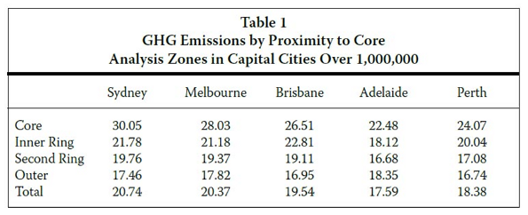
    Source: Greenhouse gas emissions, tonnes per capita, Housing form in Australia and its impact on greenhouse gas emissions, Residential Development Council 22 October 2007, p 11

    There are a number of reasons why this should be the case. First, suburban dwellings are often newer, incorporating more energy efficient means and materials – notably, better insulation. Second, though car journeys are less greenhouse gas efficient by the kilometre, the difference is not so great, and public transit is less efficient in other ways (because it rarely takes you just where you need to go) creating extra journeys and more waste.

    What is more, the view that suburban commuting must be a greater producer of greenhouse gas emissions does not take into account the changing patterns of home and work location in the newer suburbs. Our model of the diurnal commute, into the city in the morning and back to the dormitory town at night is becoming less typical.

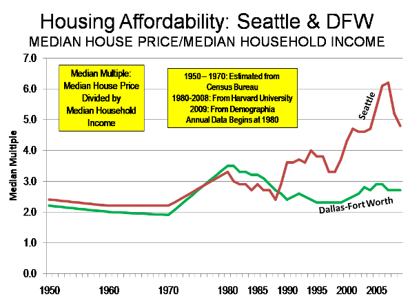
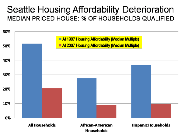
    For many people, commuting is quicker in the suburbs than in cities. It takes residents within the suburbs and exurbs 24/25 minutes, much less than the 43 minutes for those living and working in Greater London. The case for reducing energy use by living at higher densities appeals to our common sense, but less dense living might provide answers to the problems of energy and emissions.

    Suburbanisation has raised fears of social division. Anxieties about social alienation, along with those about the environment, fit into a wider account of the problems of suburbanisation, and a proposed solution, which has been called the New Urbanism.

    One group that hoped to address the problem are the New Urbanists, a group of architects and planners who have turned the perceived problem of the suburbs around and created a manifesto to reverse those negative trends. Among the best-known exponents of the New Urbanism is Peter Calthorpe, for the arguments in his books The Next American Metropolis (1993) and Sustainable Communities (with Sim Van der Ryn, 1989).

    Calthorpe argues that we are still building suburbs that are ‘increasingly out of sync with today’s culture’ failing to take into account changing household composition, falling incomes and environmental concerns – a proposition that many American “progressives” held to be strikingly confirmed by the collapse of the US housing market in 2008/9, and its wider impact on the economy.

    Intriguingly, Calthorpe’s views on planning take us far away from technical considerations into an idea of what the good life ought to be. Calthorpe says that ‘we need to start creating neighbourhoods’, arguing that, ‘Our faith in government and the fundamental sense of commonality at the centre of any vital democracy is seeping away in suburbs designed more for cars than people, more for market segments than communities.’

    The New Urbanists were an influence on Britain’s Urban Task Force, under Lord Rogers of Riverside, who drew up the British government’s planning policy in the document Towards an Urban Renaissance in 1998. Rogers, too, favoured higher densities, mixed use and an end to suburban sprawl.

    Folding the idea of preserving our social capital into the broader ideas of environmentalism, New Urbanists, the Urban Task Force and Herbert Girardet have all gravitated towards a concept of ‘sustainable communities’. It is a concept that is at once recognisable and at the same time very vague. Still, it has been an enormous influence on policy makers, who have tried to give substance to its implications.

    However, the evidence is clear that despite the many policy initiatives that have been taken to create ‘sustainable communities’, developers, and perhaps consumers, too, have resisted the appeal. First, take the case of Europe. Analysis of 42 west European cities shows that in all but one (Berlin) the suburbs and exurbs are growing faster than the core.

    In 1965 44 million people lived in the center of these 42 cities, while 42 million lived in the suburbs and exurbs. By 2000, the inner city population had dropped to 39 million, while the suburban had grown to 71.6 million. On average, inner city populations declined by 13 per cent, while suburban and exurban populations increased by 113 per cent.

    • For example Madrid’s inner city population grew from 2.25 million to 2.4 million between 1965 and 2000, but its suburbs grew from 125,000 to 2.1 million.
    • Over the same period, Frankfurt’s inner city declined from 695,000 to 641,000, while its suburbs grew from 755,000 to 1.25 million
    • Brussels’ inner city shrunk by 30,000 to 137,000, while its suburbs grew from 1.8 to 2.3 million.
    • Even Barcelona, poster-boy for urban densification, saw its core decline from 1.6 million in 1965 to 1.5 million in 2000, while its suburbs grew from half a million to 2.26 million over the same period.

    Source: Western Europe: Metropolitan Areas & Core Cities 1965 to 2000/2001, Demographia, http://www.demographia.com/db-metro-we1965.htm.

    Policies that try to contain sprawl run against the grain of human nature. Many, even most people aspire to live at lower densities than they do right now.

    Still, there is a point to the Urban Renaissance. The gentrification of canal and riverside districts, and the creation of ‘cultural quarters’ is a well-documented trend. This was the sense in which there was an urban renaissance in the noughties: well-heeled yuppies took back parts of the inner city. Often single, they had less need of gardens and preferred loft living in Shoreditch or central Zurich to a detached house in the Suburbs, which were coming to be less exclusive, anyway.

    These developments should lead those polemicists painting the suburbs as the greedy well-to-do and the inner cities as disproportionately occupied by the suffering poor to recalibrate their argument. Tim Butler, Chris Hamnett and Mark Ramsden’s analysis of London’s employment in the 2001 census shows that outer London and the South East is more working class than inner London.

    The image of black inner cities and white suburbs is changing, too. Many major cities are suffering ‘black flight’ as black Americans move out to the more affordable suburbs: Chicago, Los Angeles, Houston, Dallas, San Diego, Washington and Oakland. San Francisco’s black population is down from 13.4 to 6.5 per cent.

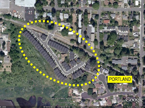
    Not only do the New Urban policy prescriptions coincide with the recent gentrification of inner cities, there is some evidence that they have helped it. Portland, where the adoption of an urban growth boundary (or green belt) was intended to densify the city and protect the country, has seen house prices rise much faster than the national average (it was below that, now it is above). Inside Oregon’s protected ‘farm land’ many farmhouses turn out to be just country homes for the wealthy disguised as farms

    To show that Greenwich Millennium Village was not just more riverside yuppie flats, but a real community, architect Ralph Erskine built in a combined school and health centre, except that an old school, Anandale, had to be relocated from the centre of Greenwich to the peninsula to provide the children – and spookily, it has kept its old catchment. Erskine’s Potemkin Village recruits children from Greenwich to act the part of the local community. A few parents objected at first, but most changed their minds when they saw the quality of the facilities. Around ten of the families in the Village proper send their children there, and of those, the majority are in the 20 per cent of new homes that earmarked for social housing. Like other attempts to reinvent the village in the town, such as the Bo01 estate in Malmo, Sweden, Erskine’s Greenwich peninsula is overwhelmingly upper middle class.

    It is pointed that in Britain, where, thanks in part to Lord Rogers, planning restrictions on new development were greatest, there was no boom in housebuilding, unlike much of the rest of the world. Of course there was a boom in house-prices – quite a phenomenal one. But all through the period 1997 to 2008 house-building fell below the rate needed to replace Britain’s dilapidated housing stock.

    The New Urbanism was always rather more than an architectural style, but also a vision of the good life. It hoped to address the social divide, and the solipsistic withdrawal from city life. Curiously, it seems if anything to have played a part in accelerating the social divide, in particular the gentrification of inner city enclaves. Far from making the city more diverse, the new urbanism seems to be making it more uniform. In London the trend towards in-fill by building on brownfield land has had the unintended effect of the loss of green spaces in the City. In the north of the city, Londoners gathered to protest at the recreation of urban overcrowding, when Islington’s municipal authorities planned to force yet another apartment block on top of garages in Pilgrim’s Way.

    The New Urbanism describes one trend in society, the gentrification of inner cities. But many more people want to move outwards, to cheaper and more spacious homes. As communications improve, and more land is released from farm use by rising agricultural productivity, that shift towards more dispersed dwellings should find its place in architecture and planning theory, too.

    Ultimately more dispersed patterns of living lead to more dispersed commuting.

    South East England, the Bassin Parisien, Central Belgium, the Dutch Randstad, Rhine-Ruhr, Rhine-Main, Northern Switzerland, and Greater Dublin are examples of what geographers call polycentric urban regions. When industry moves out of monocentric cities, it disperses along valleys and communication lines.

    But the growth of Mega City Regions does not mean the countryside is all being concreted over. On the contrary, these economic regions are a lot greener, a lot more dispersed than the twentieth century city. Exurbs and edge towns are being populated in the yawning green spaces in between the industrial estates.

    The issue that needs to be addressed is: Can We Imagine A Dispersed Future?

    Far from being necessarily de-humanising, dispersed settlements are an opportunity for an enlargement of the human spirit. To imagine that there is anything in physical proximity that is essential to community is to confuse animal warmth with civilisation, and an unfortunately deterministic view of architecture’s relationship to society. But worst of all it misses out the great alternatives that are waiting to be made in new communities across the country.

    James Heartfield is author of Let’s Build! Why we need five million homes in the next ten years, and a director of www.Audacity.org.