Category: planning

  • Low Hanging Fruit

    As a San Franciscan I get a lot of raised eyebrows when I mention that I recently bought property in Cincinnati. “Huh?” Then I walk them through it. Here’s the mom and pop business district along Hamilton Avenue in the Northside neighborhood during a recent Summer Streets event. This is a classic 1890’s Norman Rockwell Main Street with a hardware store, a Carnegie library, barbers, cafes, bars, funky little shops, and seriously good architectural bones.

    Screen Shot 2015-08-27 at 1.05.03 AMTravis Estell UrbanCincy

    Screen Shot 2015-08-27 at 1.04.38 AMTravis Estell UrbanCincy

    Screen Shot 2015-08-27 at 1.04.25 AMTravis Estell UrbanCincy

    It’s the perfect human scaled neighborhood. Kids walk to school. Older people make their way to shops and the farmers market on foot. Riding a bicycle to work is a normal natural activity that doesn’t involve spandex and Tour de France levels of endurance. Bus service to the university and downtown is frequent and convenient. And you can hop on the highway and be anywhere in Cincinnati in minutes.

    Screen Shot 2015-08-28 at 1.39.24 AM

    Screen Shot 2015-08-28 at 1.50.14 AM

    Screen Shot 2015-08-28 at 1.47.48 AM

    Screen Shot 2015-08-28 at 1.49.25 AM

    I tell folks around here that Northside is the kind of neighborhood where you can buy a quality home next door to great neighbors like these and thisand enjoy public events like this for less than the cost of a really good parking space in California. No one builds homes or neighborhoods like these anymore. We no longer have the culture that created these places.

    Screen Shot 2015-08-28 at 4.12.27 AMGoogle

    Screen Shot 2015-09-05 at 4.00.34 AM

    Screen Shot 2015-09-05 at 3.59.17 AM

    Screen Shot 2015-09-05 at 4.00.13 AM

    Screen Shot 2015-09-05 at 3.21.11 AM

    Screen Shot 2015-09-05 at 3.20.05 AM

    Screen Shot 2015-09-05 at 3.20.45 AM

    On the one hand Northside is a compact walkable neighborhood with a distinctive urban feeling at its center. But on the other it’s surrounded by forested hills, a vast historic cemetery, and productive small scale agriculture with farm houses that date back to the 1840’s. It’s a true suburb in the best sense of the word. It offers a good balance of urban convenience and vitality at your front door with the countryside at your back.

    Screen Shot 2015-08-28 at 2.16.43 AMGoogle

    Screen Shot 2015-08-27 at 9.17.59 PM

    Screen Shot 2015-09-05 at 4.55.02 AM

    Screen Shot 2015-09-05 at 4.55.23 AM

    I spend a lot of time talking to people who long for a particular kind of urban living environment. It’s not Manhattan or Hong Kong exactly. It’s smaller and more intimate. It’s more like a friendly small town with ready access to big city opportunity and culture. The old street car suburbs of the 1880’s to 1940’s like Northside are pretty much spot on. But we just haven’t built great urban places like these for three or four generations. As a society we don’t seem able to do it any more.

    Screen Shot 2014-10-27 at 12.16.25 PM

    Screen Shot 2014-10-27 at 11.03.26 AM

    Screen Shot 2014-10-27 at 12.08.29 PM

    Screen Shot 2014-10-27 at 12.17.27 PM

    Screen Shot 2014-10-27 at 11.05.22 AM

    In most places built after about 1950 you can live in a French Provincial tract house on a cul-de-sac near the strip malls and office parks, or… you can live in a Spanish colonial tract house on a cul-de-sac near the strip malls and the office parks. Those are your modern choices. The best you can hope for is an enlightened city planner or civil engineer who stripes a few bike lanes on the sides of the high speed eight lane arterials. Big whoopee.

    New Urbanists and the Smart Growth crowd are up against a massive wall of cultural resistance and institutional barriers. Trying to build new towns in the historical pattern or retrofit post war suburbs is not for the faint of heart. Personally I don’t have the desire to chip away at that mountain. Life’s too short. But there’s so much low hanging fruit out there. Neighborhoods like Northside exist all over the country. They’re already fabulous. They’re already filled with great people. They’re often very reasonably priced. And the best part is that all the obstructionist people who hate walkable urban places and obsess about how to accommodate all the cars have self-selected out. They live an hour away in the distant suburbs and want nothing to do with the city.

    John Sanphillippo lives in San Francisco and blogs about urbanism, adaptation, and resilience at granolashotgun.com. He’s a member of the Congress for New Urbanism, films videos for faircompanies.com, and is a regular contributor to Strongtowns.org. He earns his living by buying, renovating, and renting undervalued properties in places that have good long term prospects. He is a graduate of Rutgers University.

    Lead photo by Travis Estell UrbanCincy

  • Traffic Congestion: The Latest Urban Mobility Report Ratings

    In recent years there has been a proliferation of traffic congestion rating reports. Tom Tom and Inrix are now making it possible to compare traffic congestion in Louisville or even Lexington to Moscow or Paris. The Castrol Magnatic Start-Stop Index adds places like Jakarta and Bangkok. But the granddaddy of them all is the Texas A&M Transportation Institute Urban Mobility Report, which has just been released with 2014 data.

    Los Angeles

    Los Angeles remains the most congested major urban area in the nation with an average 43 percent added to travel times during peak hours. This article discusses the largest urban areas in the 53 US metropolitan areas with more than 1 million population.

    Los Angeles is long been the champion of traffic congestion in the United States. Since Texas A&M began publishing a traffic congestion scorecard in 1982, Los Angeles has usually had the worst traffic congestion, though Houston was reported to have the worst congestion for a few years in the mid-1980s.

    It should not be surprising that Los Angeles has the worst traffic congestion. Los Angeles is the nation’s most densely populated larger urban area, with 7000 residents per square mile. This high density means that the demand for both car and truck travel is higher than it would be in a lower density city. The Los Angeles freeway system is extensive and its roadways tend to be very wide. Part of the problem is that much of the planned freeway system was not built, such as the Slauson Freeway, the Reseda Freeway, the Topanga Canyon Freeway, the Laurel Canyon Freeway, the Beverly Hills Freeway and the missing link northern extension of the Long Beach Freeway through South Pasadena. None of these freeway cancellations drove people to transit, as some might suggest, as traffic volumes just continued to increase. Despite billions that were spent on rail and busway systems, Southern California’s largest transit system continues to draw fewer riders than when there were only buses in 1985.

    Congested in Other Urban Areas

    The top 10 congested urban areas include two that share commuting sheds with larger urban areas. These are third-ranked San Jose and 10th ranked Riverside-San Bernardino, which can blame part of their traffic congestion on their larger neighbors, Los Angeles and San Francisco (Figure 1).

    San Francisco is the second most congested urban area in the nation. The three most congested urban areas are also the three densest urban areas, Los Angeles, San Francisco and San Jose. Seattle ranks fourth and Portland ranks fifth, despite their much lower densities. Seattle’s intense traffic congestion is understandable, given its long, narrow geographical shape and the fact that there are only two north to south freeway routes through the urban area. Moreover, things are likely to get worse, as Seattle seeks to implement urban containment (densification) policies that are likely to worsen traffic congestion (Greater  traffic congestion is associated with higher densities).

    Portland has obtained the worldwide praise of urban planners who like its densification and anti-automobile policies. Portland, however is paying the price for that with traffic congestion 80 percent as bad as Los Angeles, even with a population density barely half that of Los Angeles.

    Austin may also be surprising, because it has a relatively small population (about 2 million) compared to most of the 10 worst congested urban areas. Austin was not large enough to justify more than a single route when the interstate system was designed in the 1950s and was very slow to develop its freeway system. At the same time, in recent years Austin has been the fastest-growing major metropolitan area in the United States, which has also added to traffic pressures.

    The least traffic congestion is in Richmond, which has also been estimated to have the best composite traffic congestion among international scorecards. Most of the least congested urban areas have metropolitan population between 1 million and 2 million residents and are located in the East, South or Midwest (Figure 2).

    Wasted Fuel

    Driving in congested traffic reduces fuel economy and results in wasted fuel (each gallon of gasoline consumed produces the same amount in greenhouse gas emissions). New York and Washington have the largest amount of wasted fuel per commuter, followed by San Francisco, Boston and Portland (Figure 3). The least wasted fuel per peak period commuter is in San Diego, Raleigh, Richmond, Jacksonville and Birmingham (Figure 4).

    Changes Since 1982

    There have been major changes in traffic congestion indexes among the 53 urban areas since 1982. San Jose has experienced the worst percentage point increase in excess travel time, adding 27 percentage points to its excess peak period travel time. Riverside-San Bernardino, Austin, Portland and New Orleans round out the five urban areas with the greatest increases in traffic congestion (Figure 5). With less growth in recent decades, however, traffic congestion has not increased enough to place in the worst ten in trend.

    The urban areas best at controlling their traffic congestion include some surprises. Dallas-Fort Worth has been one of the three fastest growing metropolitan areas in the high income world over the period, but has managed to keep up with its traffic congestion as well as any other urban area (Figure 6).

    Similarly, Phoenix has been very rapidly growing and has tied Dallas-Fort Worth for first place in best traffic congestion trend. Phoenix undertook a substantial Freeway building program in the 1980s. Detroit also ties Dallas-Fort Worth and Phoenix, though this reflects its long term economic difficulties and shows that better traffic congestion that results from less growth and job creation is not a positive. Five urban areas tied for fourth best traffic congestion trend, Richmond, Tampa St. Petersburg, St. Louis, Indianapolis and Houston. Like Dallas-Fort Worth, Houston was among the three fastest growing metropolitan areas of more than 5 million people over the period. Like Phoenix, Houston began a major freeway and arterial street improvement program in the late 1980s (perhaps partially in response to the publicity about having the worst congestion).

    Four Other Cities

    Four urban areas rank in the worst ten in each of the categories of traffic congestion, wasted fuel and congestion trend. San Jose abuts San Francisco which has the second worst congestion in the nation. Among the four, Portland is the most consistent, ranking 5th worst in traffic congestion, tied for 5th worst in wasted fuel and ranked fourth worst in congestion trend. Portland also seems the most out of place, being smaller and not having a more congested, larger urban area abutting it. New York is not a surprise, being the nation’s largest urban area, and having many bridges and tunnels, which concentrates traffic. Seattle has long been one of the most congested urban areas and also has geographical challenges, with a number of water crossings, as well as its limited north-south freeway capacity.

    The Texas A&M Annual Mobility Report pioneered the way for important urban competitiveness information that allows comparisons by public official and companies that were not possible before. The latest edition advances that purpose.

    Wendell Cox is Chair, Housing Affordability and Municipal Policy for the Frontier Centre for Public Policy (Canada), is a Senior Fellow of the Center for Opportunity Urbanism (US), a member of the Board of Advisors of the Center for Demographics and Policy at Chapman University (California) and principal of Demographia, an international public policy and demographics firm.

    He is co-author of the "Demographia International Housing Affordability Survey" and author of "Demographia World Urban Areas" and "War on the Dream: How Anti-Sprawl Policy Threatens the Quality of Life." He was appointed to three terms on the Los Angeles County Transportation Commission, where he served with the leading city and county leadership as the only non-elected member. He served as a visiting professor at the Conservatoire National des Arts et Metiers, a national university in Paris.

    Top Image: Los Angeles Traffic Congestion: AM Peak, September 2, 2015 From: Google Traffic

  • An Improbable And Fragile Comeback: New Orleans 10 Years After Katrina

    In the fall of 2005, many saw in postdiluvial New Orleans another example of failed urbanization, a formerly great city that was broken beyond repair.Yet 10 years after a catastrophe that drove hundreds of thousands of its citizens away, the metro area has made an impressive comeback.

    New Orleans’ resurgence since Katrina has come courtesy of $71 billion in federal funds and the determination and verve of New Orleanians themselves, as documented by Tulane geographer Rich Campanella, who provided research and direction for this article. It also benefited from the generosity of thevolunteers who worked in the recovery efforts as well as that of neighboring cities, notably Houston, which housed thousands of evacuees. Many have now returned, joined by newcomers from around the country, determined to turn around the city. “A city,” notes urban historian Kevin Lynch, “is hard to kill,” and New Orleans is proving that assertion.

    New Orleans’ comeback reflects not only improved levees and disaster management planning but a break from the region’s famously corrupt politics. Author Joel Garreau once described the city as a “marvelous collection of sleaziness and peeling paint.”  Today the metro area, and Louisiana, is earning higher marks for efficiency and business friendliness.  In Forbes’ annual ranking of the Best States For Business, Louisiana has risen from dead last in 2006 to 29th place in 2014, while Chief Executive Magazine ranks the state as having the ninth best business climate in the country, up from 45th in 2008.

    Perhaps most compelling has been the improvement in the public schools, which were  once among the worst in the country. After the storm, most of the campuses were converted to charter schools, which now educate over 80% of the parish’s schoolchildren. New Orleans now outperforms not only the rest of the state but the nation in terms of high school graduation rates, which have risen to 73% in 2014 from 54% in 2004, and the percentage of students on grade level in grades 3-11 is at 68%, up from 25% in 2000.  As Allison Plyer, executive director of the Greater New Orleans Community Data Center, put it in 2013, “Greater New Orleans is in some ways rebuilding better than before.”

    Growth, But Also A Rebound In Poverty

    The improvements in governmental institutions have, along with federal aid, sparked something of a jobs boom in New Orleans. The metro area recovered all the jobs lost in the recession by 2012 while the nation remained 3% below its pre-recession level.  The economy has expanded into some new sectors, such as digital media, while there has been a strong recovery in longtime core sectors liketourism and shipping, with an expansion of the port. After lagging the country for a generation, post-Katrina New Orleans surprised everyone by outperforming it.

    But there are signs that New Orleans’ rate of growth is leveling out, as might be expected with the tailing off of federal recovery spending. In our annual ranking of the cities creating the most jobs, themetro area has dropped from 26th place in 2013 to 43rd. This slowdown could worsen the biggest challenge facing New Orleans: its historic legacy of poverty.

    Greater New Orleans and the central city in particular have among the nation’s highest poverty rates and inequality. Even before Katrina, the city had over 26,000 blighted properties, a number that doubled after the storm.

    As more evacuees have returned, poverty rates in the city and the metro area have resurged. Between 2007 and 2013 Orleans Parrish’s poverty rate rose from 21% to 27%, just about where it was in 1999. At the same time, the gap between white and African-American incomes and poverty rates remain well above the national averages.  Incarceration rates in Orleans parish are almost four times as high as the national average, and  the rest of the metro area also has incarceration rates considerably above the national average.  New Orleans’ murder rate fell to the lowest level last year since 1971, but it was still the ninth highest among major U.S. cities.

    A Demographic Resurgence

    Yet some new demographic trends offer hope.Critically, the region finally has begun to reverse a demographic decline spanning more than a generation in which the urban core steadily lost young, educated people and families to the suburban periphery and beyond.  

     The immediate aftermath of Katrina saw an influx of “YURPS,” or Young Urban Rebuilding Professionals — urbanists, environmentalists and social workers who headed South to work in the recovery efforts, in nonprofits and government programs, seeking to be part of something important.After that came a wave of well-educated professionals, who saw personal opportunity in the region’s rebounding economy. Campanella estimate this latter group at around 15,000 to 20,000strong.   Along with them, says Campanella, have come a fair number of artists, musicians, and creative types seeking to join in what they perceived to be an undiscovered bohemia in the lower faubourgs of New Orleans.

    The New Orleans metro area’s population of college graduates increased by roughly 44,000 from 2007 to 2012, a 25% increase, double the national average of 12.2% over that span.

    These educated newcomers are widely credited not only with helping rebuild New Orleans, but also sparking an increase in start-up companies well above the national pace and boosting the city’s economic diversification. Employment in the New Orleans area’s information sector — high-paying jobs in entertainment, games, software — grew 21.2% between 2007 and 2012, more than twice the national average, according to Praxis Strategy Group.

    Is Gentrification A Threat?

    This promising development, however, brings with it a set of problems, among them concern, particularly among African-Americans, about gentrification of inner-city neighborhoods. Many African-Americans, notes city employee Lydia Cutrer, have “trust issues after many broken promises, and feel like outsiders are taking over.” Or, as former New Orleanian Sherby Guillory, a health care worker and now a Houston resident put it acidly, “They want to build a shining city on a hill, but without the people.”

    A map of the city by Campanella (below) shows where this turnover in population is the most advanced. He observes that the newcomers are attracted to a particular type of neighborhood – places with distinctive, historic housing stock, and close to areas that have already gentrified, or that never economically declined, like the Garden District. The arc of gentrification spreads through uptown New Orleans, around Audubon Park and Tulane and Loyola universities, with a curving spout along the St. Charles Avenue/Magazine Street corridor through the French Quarter and into the Faubourg Marigny and Bywater. These areas have in many cases been incubators of New Orleans’heavily African-American music and food culture, and now are losing some of those old connections.

    Courtesy of Richard Campanella

    Courtesy of Richard Campanella

    As elsewhere gentrification is widely welcomed in the real estate and business communities, but also poses dilemmas, even for newcomers. Indeed gentrification threatens to undermine one of the very reasons young people are so attracted to New Orleans — its unique local culture. Boilerplate yuppie restaurants selling beet-filled ravioli is no substitute for fried okra and other traditional specialties.

     The Physical Challenge Of Rebuilding

    As Katrina demonstrated all too well, poverty in New Orleans is deeply intertwined with  the geographic challenges of the region. Most predominately African-American neighborhoods were located in the low-lying areas of the city, easily susceptible to flooding, while more affluent, usually white neighborhoods were on higher ground.  

    Some have suggested moving the region’s entire population to higher ground, but political and fiscal realities, plus social resistance to closing down heavily damaged, far-flung neighborhoods, paved the way for resettlement patterns that have not reduced human exposure to the hazard of surge flooding.

    But there’s no question that $14.5 billion in taxpayer dollars have gone to good use in keeping thosehazard at bay — at least for the next few decades. The Army Corps of Engineers’ new Hurricane Storm Surge Risk Reduction System — composed of heightened levees, floodwalls, surge barriers, gates, and pumps — now  protects the metropolis from storms that have a 1% change of occurring in any given year. That’s much less than the city needs, but it’s a lot more than it had before Katrina, and the Risk Reduction System (note that it’s no longer called a “flood protection system”) worked well during Hurricane Isaac in 2012.

    That’s the good news. The bad news, Campanella observes, is that the coastal wetlands beyond the system, starved of sediment and freshwater, continue to subside and erode at rapid paces in the face of rising sea levels and intruding sea water.

     A Difficult Road Ahead 

    Solving New Orleans’ geophysical problems is critical for long-term growth.  “We have to approach this as a win-win proposition,” says the Nature Conservancy’s Seth Blitch. “Everyone knows if we do nothing, it’s a lose-lose for everyone.”

     In the near term obstacles include the growing disparities of race and class, the fall in oil prices, and the strengthening dollar,which could slow the recent surge in capital investment into Louisiana’s industrial economy that has come on the heels of the surge in natural gas production.  

    While challenges abound, progress over the past 10 years is undeniable, and few  would have predicted the city would have come this far so soon in addressing its long-term challenges. “None of this would have happened without Katrina,” says Loyola theologian and philosopher Michael Cowan. “It changed forever what had been an inertial environment. After Katrina, it was like operating in zero gravity. Katrina broke the pattern.”  

    This piece first appeared at Forbes.com.

    Joel Kotkin is executive editor of NewGeography.com and Roger Hobbs Distinguished Fellow in Urban Studies at Chapman University, and a member of the editorial board of the Orange County Register. He is also executive director of the Houston-based Center for Opportunity Urbanism. His newest book, The New Class Conflict is now available at Amazon and Telos Press. He is also author of The City: A Global History and The Next Hundred Million: America in 2050. He lives in Orange County, CA.

    Photo montage by Richard Campanella.

  • Book Review: Designed For The Future by Jared Green

    By the fifth word of Designed for the Future, Jared Green had almost lost me. By the end, he hadn’t quite gained me. This slim, visually interesting handbook presents “80 practical ideas for a sustainable world” from the noted author of The Dirt, a weekly blog sponsored by the American Society of Landscape Architects. Green’s earnest mission is to find hope for the future, and with this book, he edits a collection of essays that points to some projects that do.

    It is a slim, portable, affordable book for the busy design professional in any discipline who is trying to wrap his or her head around the slippery notion of sustainability. Green’s introduction summarizes his process, and then presents each idea in a two-page spread. The ideas range from using mushrooms, which are now compressed into insulation panels (don’t eat your wall), to Rome as an example of walkable urbanism (don’t tell the taxi drivers). Each idea is presented with a photograph and a neat summary of how it contributes to the future. The point of all this activity, however, remains elusive in this otherwise intriguing little book.

    Designed For the Future poses the question to eighty thinkers: “What gives you hope that a sustainable future is possible?” Each replies with a brief description of a project that inspired them to see a way forward. Among the notable but not entirely successful attempts to provide an answer is an essay by Elizabeth Mossop, “Changing Course,” about a design competition to improve management of the Lower Mississippi River in Louisiana. She notes that up until now the river, managed by scientists and engineers, has lost wetlands and added pollution to the Gulf of Mexico. Giving designers a turn might be a good idea, as she suggests. While I’m sympathetic, I keep thinking of the woeful mismanagement of the Everglades in my home state of Florida, and how often well-intentioned healing practices seem forever delayed. It is as if we cannot collectively bring ourselves to veer off our current pathway, no matter who is in charge.

    Some essays, however, are the real thing. “Project Row Houses” by F. Kaid Benfield showcases artist Rick Lowe’s community development project to preserve 22 wood-frame shotgun homes in Houston. The project uses buildings that are already built, improving them rather than replacing them; it provides dignified shelter for historically disadvantaged African Americans, and has spawned urban agriculture, education, and similar enterprises. This is what sustainability should be all about: taking our stuff and making it better, rather than abandoning it and making more stuff.

    Many of the essays are somewhat predictable paeans to urban life. “Seven Dials,” by New Urbanist Victor Dover, extols the virtues of this tiny London street intersection and its surroundings. Developed in the seventeenth century, this West End neighborhood has gentrified nicely into a walkable community. The accompanying photo seems too good to be true: pedestrians actively engaged in their public realm, not a car in sight, the sundial festooned with Union Jacks. As a prosperous, white, upper-middle-class community, it is an easy example of the urbanist’s dream come true, but well nigh impossible to replicate in America’s big-box car culture. Perhaps it could survive as a simulated city somewhere.

    Green’s inclusion of an analysis by Anthony Flint of Unité d’Habitation inspired me. This 11-story apartment block, built in France after World War II, lets daylight in on both sides of each apartment,, and features rooftop uses. It was architect Le Corbusier’s first phase of his Radiant City plan. The design was much maligned in the 1990s by urban activists as a misanthropic disaster, who claimed that traditional neighborhoods were better. But the Unite d’Habitation turned out to be a pretty nice place after all, while many well-intended traditional neighborhood developments have had poor results. There is hope, after all, for modernism.

    Green’s second-to-last entry is an essay on vernacular architecture by Li Xiaodong, a Beijing architect and professor at Tsinghua University School for Architecture. In some ways, this is the book’s most important essay. “It’s about the process, not about design,” says Li, adding, “Architecture should be based in a dialogue with local conditions and lifestyles. It should be a product of that dialogue.” Li beautifully captures the essence of sustainability, seeing it as a thought process, not a look or a lifestyle; about reacting intelligently to local conditions with materials and labor available on hand.

    Green’s examples are heavy on the land planning side of things. Innovations such as 3-D printing are missed, and economics and technology are entirely ignored. And a few essays seem repetitive: Paris is in the book twice.

    The focus is on people, land, water, and air. Reducing pollution and waste are important, and his book illustrates examples of this in abundance. We seem to have bounced back from the bad old days of the Ohio River on fire and air so thick you can take a bite out of it. This book offers assurance we are not backsliding into the wicked ways of the past.

    Reducing the amount of stuff we take from the earth also figures big. Densifying cities, which conserves open space, is the topic of more than one essay. Staying local and using renewable, vernacular materials also has resonance with these contributors. Green’s essayists portray a future where resources are extracted a little more gingerly, and open land is conserved and even integrated into human habitation on a small scale to improve our relationship with nature.

    The classical definition of sustainability includes two other tenets: increasing biodiversity, and spreading a little justice around to other species. The book provides scant evidence that the future holds any hope for these two notions. The wind farm in Lester Brown’s “Wind Mega Complexes” essay even goes against these principles, showcasing the giant wind turbines blamed for bird kills. Regarding biodiversity, Green misses the Mesoamerican Biological Corridor project, an oversight perhaps due to his self-proclaimed “random process” for choosing contributors.

    Green begins the book with the statement, “We can’t give in to fatalism.” For the symptoms of fatalism, he presents examples of cures. Someone, somewhere, is treating these symptoms, he reassures us, saying that things are getting better in many different ways.

    A deeper disease, however, lies undiagnosed in this book. Cities are denser, yes; but they increasingly all look the same. Wetlands are saved, yes; but we continue to “manage” them, as if it would be awful if they were left to themselves. Just when public spaces are getting nicer, most Americans prefer to remain indoors, glued to their devices. None of these imply a future of abundance and beauty. Until our own meaning and purpose are more fully addressed by our present society, it seems difficult to conceive of the kind of future envisaged in Designed For the Future.

    Richard Reep is an architect with VOA Associates, Inc. who has designed award-winning urban mixed-use and hospitality projects. His work has been featured domestically and internationally for the last thirty years. An Adjunct Professor for the Environmental and Growth Studies Department at Rollins College, he teaches urban design and sustainable development; he is also president of the Orlando Foundation for Architecture. Reep resides in Winter Park, Florida with his family.

  • Historic Districts: The Past or The Future?

    Preservation seems like an easy idea to support. Who would be against it? History, character, and a sense of place are what great communities are all about. They generate tourism and makes us all culturally richer. Landowners in historic districts even enjoy higher land values than nearby landowners in newer, usually blander developments. What’s not to like?

    Apparently, a lot. Cities unilaterally impose ordinances from time to time, regulating building size, shape and use, and rarely are there complaints, although the changes affect everyone in the city. Here in Florida, building codes were recently stiffened, causing buildings in the entire state to become more expensive, and there were no complaints to speak of. But in the small community of Winter Park, when a proposal was floated to make obtaining historic district status less onerous, indignant protesters with cries of “property rights” were voiced. Protesters who were shy about fighting the State and the City may have finally found, in individual neighborhoods, a small enough foe to bully.

    Protesters claim that they fear restraint of trade, and they’re hoping to cash in on rising land values, particularly where they have been historically low. A historic designation might make an owner think twice before knocking a house down.

    There’s mirth in Cyria Underwood’s eyes as she tells us about coming here to Winter Park from Louisville, Kentucky. A tall, elegant African American woman, Underwood works at the Hannibal Square Heritage Center, and observes Winter Park’s preservation battles like this: “Black people have an oral history tradition, and it’s a good thing we do. We don’t expect our own buildings to get preserved. So here on the West Side, we hand down our oral history from mother to child, father to son. It’d be nice to see preservation taken seriously,” she muses, her eyes still smiling, “but African Americans have learned to make do without it.”

    Interest rates remain low. In neighborhoods like the West Side, where Cyria works, owners feel the pressure to sell. Hannibal Square, built originally for blacks in the 1880s, today houses a mix of families, some of whom go back to the town’s early days. Walkability, playgrounds and parks make this a dream community for urbanists; many residents ride the buses that travel up and down Denning Avenue, and Sunrail’s Winter Park Station is a couple of blocks away. Finally, it seems, this area has come into its own and become a hip, urban community at long last.

    “However,” murmurs Cyria, her eyes twinkling, “the wolf is at the door.” She’s referring to developers who buy small houses on small lots and replace them with much larger homes, townhomes, and even multifamily clusters. West-siders have been clinging on by the skin of their teeth. Service jobs with modest incomes and part-time work (much of it a long bus ride away) have kept this neighborhood afloat. While land values all around have skyrocketed, the West Side — historically African-American — has not been rewarded with such good fortune. Property values are, to put it politely, stable.

    Fairolyn Livingston moved out of the West Side in the ’70s, but comes back frequently. She explains that when a West Side homeowner sells, he or she walks off counting the cash. But Livingston cites more than one seller who couldn’t replace the Winter Park lifestyle with the proceeds from his or her home, and ended up moving into poorer and even less upwardly mobile parts of town. So goes gentrification: the new buyer, often white, unwittingly banishes an African American family to a lower stratum, hardening class divisions.

    Livingston is candid about the younger newcomers. Asked whether they join the neighborhood churches, she chuckles. “Oh, no. There’s no interaction with our community.” The new buyers, however, benefit from the short walk to Park Avenue’s chic restaurants and shops, and can Sunrail to happy hour downtown. The West Side’s character, meanwhile, dissolves under the homogenous new face of urban America, where everywhere resembles everywhere else.

    Cyria Underwood, Fairolyn Livingston and many others are unworried about the preservation battles being waged in Winter Park right now. This is not surprising: preservation of the West Side has not been high on the City’s agenda. The same development pressures are being fought all over.

    Locally, Friends of Casa Feliz, a Winter Park preservation organization, will be co-hosting a West Side History panel discussion this autumn to help keep what is left of the architecture.

    It’s part of keeping a conversation going about the local urban future. Historic districts come into being in most places with a simple majority, but Winter Park’s requirement of a supermajority makes them difficult and rare. Protesters against preservation see this as just fine, and do not want property rights to change.

    While he isn’t a vocal protester, realtor Mark Squires is a realist. With a Clark Gable smile and wink, he is a true denizen of Winter Park real estate. “Everyone wants historic character,” Squires offers, “but nobody wants to pay for it.” Smaller, older homes have tiny kitchens and bathrooms, and are often hard to maintain. Squires and his colleagues find that, for many young couples with kids, Winter Park’s lifestyle is in high demand. The last thing on their busy agendas is fixing cast iron pipes or repainting wood trim. Many buyers want new, as the developers, builders, realtors and lenders are well aware. Every home becomes a potential knockdown, if the price fits the formula.

    Squires’ local reality is that historic preservation, while it might make everyone a little better off, makes home sales harder. Our local economy is geared towards short-term private profit, and the notion that preservation can also be profitable is rarely considered. While developers in Boston, Chicago, and elsewhere have proven that historic preservation can make money, it has yet to be seen as a both/and proposition in Central Florida. City Hall dithers over the proposed historic district ordinance while the bulldozers roll.

    Underwood is philosophical about it. “Willing seller, willing buyer, you know? You can’t control what someone does after you go.” Rich or poor, the same argument applies. The individual decides whether to push the easy button and go for new, or save a little bit of quality for future generations.

    The current wave of transactions, fueled by low interest rates and demand for in-town living, is recasting the character of her neighborhood, as well as of the more affluent areas of the East Side. If the City Commission votes to ease historic district formation, perhaps there will be more than just oral history to remember Old Winter Park by. If not, and more bungalows succumb to the McMansion, we’ll all just have to huddle up around her chair and ask for stories about the buildings that used to be here, and the people who lived within them.

    Richard Reep is an architect with VOA Associates, Inc. who has designed award-winning urban mixed-use and hospitality projects. His work has been featured domestically and internationally for the last thirty years. An Adjunct Professor for the Environmental and Growth Studies Department at Rollins College, he teaches urban design and sustainable development; he is also president of the Orlando Foundation for Architecture. Reep resides in Winter Park, Florida with his family.

    Photo of Cyria Underwood by the author

  • Special Report: Maximizing Opportunity Urbanism with Robin Hood Planning

    This is the first section of a new report authored by Tory Gattis for the Center for Opportunity Urbanism titled Maximizing Opportunity Urbanism with Robin Hood Planning. Download the full report (pdf) here.

    Across America and the developed world, we face a well-reported crisis of income stagnation, rising inequality, a declining middle class, and a general lack of broad prosperity. Yet contemporary urban planning seems disconnected from this crisis, focusing instead on pedestrian aesthetics, environmentalism, and appealing to the supposed preferences of the wealthy and the “creative class.” This approach increasingly dominates urban thinking, expressed often as New Urbanism or Smart Growth. In this perspective, dense and usually older cities like New York, Portland, and San Francisco have been held up as models. For the most part, planners see their world through the perspective of an architect – an architect of the physical form of cities. But what if they tried the perspective of an economist – an architect of opportunities for people to have a better life?

    Cities matter far more than they used to as engines of opportunity and upward social mobility – the very essence of the American Dream. As the basis of the economy has shifted from industry to services, proximity to others now matters more than ever before. A factory can be anywhere and ship its products anywhere, but, generally speaking, most services need to be in-person. This is pushing more and more of the population to agglomerate around not so much cities, as defined by their political boundaries, but major metros, including numerous suburban rings, where the vast majority of the population resides. In many metros, limited housing supply has driven up home prices and rents to levels where much of the middle and working classes are either unable to buy or must pay a heavy portion of their incomes in mortgages or rents.

    This is occurring as economic and technological factors have directed ever more wealth to a relatively small population of elites, whose demand for specialized services – whether personal spending or that of the corporations they control – has become a major part of the economy. Economic opportunity is driven not just by proximity to others in general, but by proximity to the very small but critically influential super-affluent class – what Citigroup research calls the “Plutonomy”. iv In some markets, such as Miami, New York and San Francisco, the locational preferences of this class – who often have several residences and many are foreign buyers – has been yet another driver of major metro agglomeration and higher housing prices, particularly where there are strong land use regulations.

    Family sizes have shrunk and reduced fertility rates are leading towards destabilizing demographic implosions in Europe, Japan, and China – and the U.S. trend is moving in the same direction.vi As nations seek to improve fertility rates, one of the greatest challenges is a shortage of family-friendly housing with sufficient space. If that space is not affordable, then people do the next best alternative: shrink their family size. Whereas families used to be comfortable with multiple children per bedroom, the modern standard is one bedroom for every child – not to mention the “home office” for virtual work by the dual-income parents. With the large suburban house both regulatory out-of-favor and unaffordable in some metropolitan areas, families are forced to shrink to live in expensive density, or pay very high prices and rents for what used to be considered standard middle class homes.

    The planning community generally has few answers to these dilemmas, but in practice the steps they often advocate may actually be making it worse. A dominant tenet of Smart Growth actually seeks to restrict suburban development and encourage density to contain urban expansion. Draconian regulations – and ever higher costs – are piled on any new developments. On the other side, pressure from NIMBY homeowners often limits development of any kind – including high-density. In some areas, exclusionary zoning – such as tight restrictions on multi-family housing – is used to prevent minority, disadvantaged, or lower-income populations from moving in nearby.

    All in all, the net effect is a suffocating restriction on new housing supply even as demand increases, leading to skyrocketing home prices. This has the effect of making affluent NIMBY homeowners, who are disproportionately white and older, quite happy since their homes prices, sans new competition, are almost certain to increase. But the system works like a “Robin Hood in reverse” for younger, middle and working class families that lose out. This is a major driver of inequality – in fact, recent analysis indicates that homeownership completely accounts for the rise in inequality in recent decades. xii Planners have to take a hard look in the mirror and face an uncomfortable truth: whether they have been conscious of it or not, they have been direct accomplices in the rise of inequality and the decline of the middle and working class.

    Download the full report (pdf) from the Center for Opportunity Urbanism.

    Tory Gattis is a Founding Senior Fellow with the Center for Opportunity Urbanism, and co-authored the original Opportunity Urbanism studies. Tory writes the popular Houston Strategies blog and its twin blog at the Houston Chronicle, Opportunity Urbanist, where he discusses strategies for making Houston a better city. He is the founder of Coached Schooling, a startup to create a high-tech network of affordable private schools ($10/day) combining the best elements of eLearning, home and traditional schooling to reinvent the one-room schoolhouse for the 21st century. Tory is a McKinsey consulting alum, TEDx speaker, and holds both an MBA and BSEE from Rice University.

  • The Evolving Urban Form: Jing-Jin-Ji (Dispersing Beijing)

    China’s cities continue to add population at a rapid rate, despite a significant slowdown in population growth. Although overall population is expected to peak around 2030, the urban population will continue growing until after 2050. China’s cities will be adding more than 250 million new residents in the next quarter century, according to United Nations projections. China’s cities will add nearly as many people as live in Indonesia, the world’s fourth largest country, more than live in Brazil and 10 times as many as live in Australia.

    Two of China’s six megacities (urban areas with more than 10 million population) are nearly adjacent, within 90 miles (150 kilometers) of one another. The urban areas of Beijing and Tianjin have a combined population of 35 million and are among the fastest growing in the world. This is an increase of nearly 60% from the 2000 population of 21 million.

    The Jing-Jin-Ji Megalopolis

    The faster growing of the two, Beijing, is the national capital. Beijing is encircled by five freeway standard ring roads or beltways. These are numbered 2 through 6, with the first ring road being surrounding the Forbidden City. Its population is served by a number of additional expressways and the world’s longest subway. For some time there has been discussion of integrating the metropolitan areas of a much larger region. A principal purpose is dispersion — to redistribute activities, such as government administration and manufacturing away from Beijing’s congested core to peripheral locations.

    Over the past year, there have been various announcements describing the process. The  megalopolis would be called Jing-Jin-Ji, and would be composed of Beijing, Tianjin and Hebei province. An alternative name would be the "Capital Economic Circle." The name, Jing-Jin-Ji is constructed of the last syllables of "Beijing" and "Tianjin," along with "ji," which is the pronunciation of the one character Mandarin abbreviation for Hebei.

    The Need for Dispersal

    Beijing has just become too dense and too crowded. Traffic congestion already is among the worst in the world. According to The Sydney Morning Herald, the situation has become so bad that officials intended to limit the population of the Beijing municipality (province) to 23 million, only slightly above the population that is nearing 22 million. They also intend to reduce the population of central districts by 15%.

    Important steps are already being taken. Construction has begun on a new facility to house Beijing municipality functions in the suburban district ("qu") of Tongzhou. This subsidiary center is a 40 minute drive from the city center. Tongzhou borders the municipality of Tianjin and, according to the Beijing Municipality government is itself growing about one-quarter faster than the Beijing municipality itself.

    There are also plans to move many of the manufacturing facilities that have located in Beijing to the other jurisdictions. The extent of the manufacturing dominance of Beijing is illustrated by the much larger "floating population," of Beijing, which consists of migrants from other parts of the country who lack local residence permission (hukou). According to data in the China Yearbook 2014, Beijing has more than double the ratio to its population of migrant workers as Tianjin and nearly 10 times the ratio of Hebei, which has more than two-thirds of the megalopolis population.

    One large automobile manufacturer has already completed moving out of Beijing to Huanghua, a county level city in the Hebei municipality of Cangzhou, which borders Tianjin to the south.

    Geography of Jing-Jin-Ji

    The jurisdictions comprising Jing-Jin-Ji have approximately 110 million residents. The gross land area is approximately 216,000 square kilometers (83,000 square miles), approximately the land area of Romania or the US state of Idaho. No one, however, should imagine a Phoenix or Portland type sprawl of such a magnitude. As is indicated the Table, the overall population density of Jing-Jin-Ji is only 500 residents per square kilometer (1,300 per square mile).  The largest urban areas comprise only 3.5% of the land area, yet contain approximately 40% of the population. Despite the massive urbanization of Beijing and Tianjin, and the other large urban areas, Jing-Jin-Ji has a population that is 40% rural.

    Components of Jing-Jin-Ji
    Jurisdiction Total Population (2013) Density (per KM2) Principal Urban Area Population (2015) Urban Density (per KM2)
    Beijing 21.2      1,300 20.2      5,100
    Tianjin 14.7      1,200 10.9      5,400
    Jing-Jin-Ji Core 35.9      1,300 31.1      5,200
    Baoding 10.2         500 1.3      5,900
    Langfang 4.4         700 0.5      3,800
    Canzhou 7.2         500 0.5      3,800
    Tangshan 7.5         600 2.4      8,700
    Zhangzhiakow 4.6         100 1.2      9,200
    Qinhuangdao 2.9         400 1.0      6,500
    Chengde 3.7         100 0.1      4,300
    Inner Jing-Jin-Ji 40.5         300 7.0      6,600
    Shijiazhuang 10.4         700 3.4    17,000
    Handan 9.2         800 2.0    11,900
    Xingtai 7.1         600 0.7      6,000
    Henshui 4.3         500 0.4    11,800
    Outer Jing-Jin-Ji 31.0         600 6.5    12,500
    Jng-Jin-Ji 109.2         500 44.6      5,900
    Population in millions.
    Jurisdition population from government sources
    Urban area population from Demographia World Urban Areas


    The Nearby Urban Areas

    In addition to Tianjin, other urban areas are expected to gain functions, jobs and residents from Beijing. Baoding, an urban area to the southwest of Beijing is expected to gain hospitals, educational institutions and government offices. Baoding has a population of 1.3 million and is a former capital Hebei, but was displaced by Shijiazhuang in 1967. Shijiazhuang, with a population of 3,4 million, is located  in the outer ring of Jing-Jin-Ji.

    Langfang is unusual in being a discontinuous municipality, part of which is an enclave surrounded by Beijing and Tianjin (as is Hebei province), and the other part located to the south of both jurisdictions. Langfang is in the path of growth of both Beijing and Tianjin. The urban area of Langfang is still relatively small, with 500,000 residents. The urbanization along the Jingtang Expressway through Langfang nearly reaches the development of Beijing to the northwest and Tianjin to the southeast.

    Tangshan is directly north of Tianjin and east of Beijing. Tangshan seems likely to benefit from the dispersion of functions, jobs and residences by virtue of its proximity to both of the megacities. A new high speed rail line has just been announced that would connect Tangshan with Beijing in 30 minutes. Tangshan gained international notoriety in 1976 when it was struck by a devastating earthquake (photo here) that virtually flattened the city and killed at least 240,000 people (estimates of the earthquake death toll reach 800,000). Tangshan has been completely rebuilt, with impressive modern architecture (photograph above, taken from an earthquake memorial), but not appreciated by all. One architectural critic has insensitively bloviated that the new architecture "has been more destructive to Tangshan’s urban history than the great earthquake." Today, Tangshan is an urban area of 2.4 million.

    Qinhuangdao, an urban area of 1 million, lies just beyond (northeast of) Tangshan on the way to Shenyang and China’s Dongbei (Manchuria). Qinhuangdao could profit from its well placed seaport.

    Transportation Improvements

    Important transportation improvements have been announced. There are plans to expand Beijing’s subway, which already has the highest ridership in the world and is second longest (after Shanghai). New suburban train lines will be built and new high speed rail lines will connect the cities within Jing-Jin-Ji that are farther apart. There will be considerable expansion of the already comprehensive expressway system, including Beijing’s seventh ring road, which is to be fully completed by 2017. Already, approximately 400 kilometers have been completed, much of it through the mountains to the west of Beijing.

    Decentralizing Beijing

    Jing-Jin-Ji would be China’s third megalopolis, joining with the Yangtze Delta (centered on Shanghai) and Pearl River Delta (centered on an axis from Guangzhou to Shenzhen). But Jing-Jin-Ji is substantially different and not so obvious a candidate for integration. Jing-jin-ji’s urban areas are located farther apart than in the Pearl or the Yangtze. Yet its concentration of development is greater, especially in the Beijing core, which provides much of the justification for decentralization.

    Wendell Cox is Chair, Housing Affordability and Municipal Policy for the Frontier Centre for Public Policy (Canada), is a Senior Fellow of the Center for Opportunity Urbanism (US), a member of the Board of Advisors of the Center for Demographics and Policy at Chapman University (California) and principal of Demographia, an international public policy and demographics firm.

    He is co-author of the "Demographia International Housing Affordability Survey" and author of "Demographia World Urban Areas" and "War on the Dream: How Anti-Sprawl Policy Threatens the Quality of Life." He was appointed to three terms on the Los Angeles County Transportation Commission, where he served with the leading city and county leadership as the only non-elected member. He served as a visiting professor at the Conservatoire National des Arts et Metiers, a national university in Paris. 

    Photograph: Tangshan’s modern architecture, from an earthquake memorial (by author)

  • Blaming Foreigners for Unaffordable Housing

    In a number of Western world cities, there is rising concern about foreign housing purchases which may be driving up prices for local residents. Much of the attention is aimed at mainland Chinese buyers in metropolitan areas where housing is already pricier than elsewhere. The concern about housing affordability is legitimate. However, blaming foreigners misses the point, which is that the rising prices are to a large degree the result of urban containment policies implemented by governments.

    London and the United Kingdom              

    The Daily Mail reports that London being deluged with foreign house buyers, who are buying not only expensive properties but also "starter homes," driving prices up. The Mail singles out Russian and Chinese buyers, many of whom pay cash for their purchases. Paula Higgins of the Home Owners Alliance lamented the fact that many foreign buyers are paying cash.  She questions the appropriateness of foreign investment in "family homes." David King, of Priced Out, said: "Foreign investment is driving up prices, making it even harder for ordinary people to get a decent place to live."

    Real estate firms headquartered in Russia are steering their clients to less expensive locations, outside London, such as to the north of England and Wales. A London real estate firm said that only 15% of its sales were to buyers from the UK. There is pressure for the government to protect local home buyers

    Certainly these investors are stepping into an already pricey market. The 11th Annual Demographia International Housing Affordability Survey found London house prices to be a severely unaffordable 8.5 times household incomes in 2014. London has the seventh worst housing affordability out of the 86 major markets rated in nine nations. The outside-the-greenbelt exurbs of London have house prices 6.9 times incomes.

    Vancouver

    Vancouver is a city of immigrants. According to data compiled by University of British Columbia (UBC) Geography Professor David Ley, nearly 90 percent of metropolitan Vancouver’s growth over the past two decades has been from foreign immigration (this article contains a graph with the numbers). Yet, there is significant concern about home purchases in the Vancouver area by mainland Chinese. UBC Professor Henry Yu’s history class described the issue in a video (Blaming the Mainlander).

    The Demographia International Housing Affordability Survey found Vancouver house prices to be a severely unaffordable 10.6 times household incomes in 2014. Vancouver has the second worst housing affordability out of the 86 major metropolitan areas rated in nine nations. Hong Kong has the worst housing affordability, with a median multiple of 17.0.

    California and New York

    Ilya Marritz of Public Broadcasting Systems (PBS) radio station WNYC remarked on how foreign investment is driving up prices in the New York and San Francisco bay areas: "There’s this relatively new trend of people buying properties in the city and not actually spending a lot of time living here." The Demographia International Housing Affordability Survey found New York metropolitan area housing to cost 6.1 times incomes, a 65% increase since before the housing bubble.

    The Diplomat, which specializes in Asia-Pacific affairs, commented that “there’s no doubt that China’s presence in the Bay Area market is driving up prices. The Diplomat quoted real estate executive Mark McLaughlin; “it’s added a demographic of buyers who, generally, take a long-term view. They’re not sellers in the next five to seven years.” Chinese buyers are sitting on much of this property as housing in the Bay Area becomes increasingly scarce, causing its value to skyrocket."

    The Demographia International Housing Affordability Survey places both San Francisco and San Jose metropolitan area house prices at 9.2 times incomes, tied for fourth least affordable in the 9 nations.

    The Los Angeles Times reports strong mainland Chinese purchasing activity in the suburbs of Los Angeles, from the San Gabriel Valley to Orange County, particularly Irvine as well as in Riverside-San Bernardino (the Inland Empire).

    The Demographia International Housing Affordability Survey found house prices to be 8.0 times incomes in Los Angeles, the 10th least affordable major metropolitan area in the Survey. Nearby San Diego prices are even higher, at 8.3 times incomes, earning it the 8th least affordable major metropolitan area in the 9 nation Survey.

    New Zealand

    Things have become more heated in New Zealand. The Labour Party opposition housing spokesperson Phil Twyford blamed foreign investors for driving up house prices in Auckland, New Zealand’s only metropolitan area with more than 1,000,000 population.

    "Kiwi families who are struggling to buy their own home want to know the impact offshore speculators are having on skyrocketing Auckland house prices. They are sick and tired of losing homes at auction to higher bidders down the end of a telephone line in another country."

    This evoked considerable criticism for ethnic insensitivity not only among New Zealand’s large Chinese minority, but also ordinary citizens. Radio New Zealand opined: "For a party that has diligently and deliberately courted the ethnic vote, including the Chinese community in Auckland, this was a risky strategy." The Economics Minister accused Labour of playing "the race card." There was predictable reaction in China, which is New Zealand’s largest goods export partner. The Shanghai Daily headlined: "New Zealand housing market debate descends into race row. "Meanwhile, the National Party government continues its difficult task of trying to reverse the consequences of urban containment policy in Auckland.

    The Demographia International Housing Affordability Survey found Auckland house prices to be a severely unaffordable at 8.2 times household incomes in 2014. Auckland has the ninth worst housing affordability out of the 86 major metropolitan areas rated in nine nations.

    Australia

    In Sydney, the Party for Freedom produced a brochure "blaming Chinese property buyers for pushing up home prices, ‘ethnically cleansing’ Australian families from their suburbs and creating a new ‘stolen generation,’" according to The Sydney Morning Herald (" Race hate flyer distributed in Sydney’s north shore and inner city"). The brochure also referred to foreign purchasers as "greedy foreign invaders," and charged them with "pricing locals out of the market." A You-Tube video was posted in which the party chairman burns the flags of China, the Australian ruling Liberal Party, the Labor Party and the Greens and images of Australia’s Prime Minister and the New South Wales Premier.

    Predictably, this brought a sharp reaction from public officials, such as Lane Cove mayor David Brooks-Horn, whose affluent North Shore community was targeted for distribution of the brochures.

    Despite this "vile attack," as New South Wales Multiculturalism Minister characterized it, there remains serious concern in Australia about rising house prices, which many blame on foreign investors aalthough avoiding the extremes indicated above.

    The Demographia International Housing Affordability Survey found Sydney house prices to be a severely unaffordable 9.8 times household incomes in 2014. This is the third most unaffordable market among the 86 major metropolitan areas rated in nine nations.  Today, The Australian Financial Review reported that the median house price in Sydney has reached $1,000,000 for the first time. This is a 23% increase in just one year.

    Melbourne, with prices 8.7 times incomes is sixth least affordable.

    "Supply, Supply, Supply"

    There is a common theme among those who are blaming foreigners for the escalation in their local house prices: foreign buyers have driven up demand, thus increasing prices and driving local purchasers out of the market. That might be a plausible theory if demand by itself raised prices. But, all else equal, demand results in higher prices only when there is a shortage of supply. And a shortage of supply is exactly what has been produced by government policies in each of the metropolitan areas described above.

    The problem lies largely with the blunt policy instrument of urban containment, which makes it virtually impossible to build on wide swaths of suburban greenfield land. Urban containment policy’s most destructive strategies are urban growth boundaries or greenbelts, which often prohibit development on virtually all greenfield sites and other regulations that deny planning permission on the majority of parcels suitable for housing on and beyond the urban fringe. The shortage of supply so important to the price increases has been produced by government policies in each of the metropolitan areas described above (Figure).

    The problem is that urban containment policy "creates its own weather." Investors are disproportionately drawn to markets where there are shortages. Sir Peter Hall and his colleagues pointed out that development plans provide a guide for developers of where to buy within the metropolitan area (in The Containment of Urban England).

    A Canary Wharf buyer in London told The Wall Street Journal: “If I could afford it I’d buy as many as I could”… “Flats [in London] are a great investment. I can’t see that changing." Nor will it so long as the "sure thing" of extraordinary house price increases supported by planning policy continues. San Francisco Bay Area public officials may as well have hung a "Welcome Speculators" banner from the Golden Gate Bridge.

    James Laurenceson, Deputy Director of the Australia-China Relations Institute at the University of Technology in Sydney, told The Sydney Morning Herald.:

    "Housing affordability is a real problem. The real reasons are right in front of our eyes – limited land releases, zoning regulations, development charges, record low interest rates and tax breaks to property investors. There’s not a Chinese buyer amongst them."

    Indeed, most of the cities above became severely unaffordable well before an affluent middle-class was enabled by China’s economic reforms.

    New South Wales Premier Mike Baird characterized the solution as "supply, supply, supply," which he sees as "the principal lever" for improving housing affordability. Housing affordability proposals that do not start with the supply shortage are little more than empty rhetoric. Attempts to blame the prices primarily on foreigners are not only misleading, but also diverts the public from the more important role played by limiting supply.

    Wendell Cox is Chair, Housing Affordability and Municipal Policy for the Frontier Centre for Public Policy (Canada), is a Senior Fellow of the Center for Opportunity Urbanism (US), a member of the Board of Advisors of the Center for Demographics and Policy at Chapman University (California) and principal of Demographia, an international public policy and demographics firm.

    He is co-author of the "Demographia International Housing Affordability Survey" and author of "Demographia World Urban Areas" and "War on the Dream: How Anti-Sprawl Policy Threatens the Quality of Life." He was appointed to three terms on the Los Angeles County Transportation Commission, where he served with the leading city and county leadership as the only non-elected member. He served as a visiting professor at the Conservatoire National des Arts et Metiers, a national university in Paris. 

    Photograph: Opera House, Sydney (by author).

  • Special Report: The Laissez Faire New Orleans Rebuilding Strategy Was Exactly That

    Urban risk may be understood as a function of hazard, exposure, and vulnerability.1 In metro New Orleans, Katrina-like storm surges constitute the premier hazard (threat); the exposure variable entails human occupancy of hazard-prone spaces; and vulnerability implies the ability to respond resiliently and adaptively—which itself is a function of education, income, age, social capital, and other factors—after having been exposed to the hazard.

    This essay measures the extent to which, after the catastrophic deluge triggered by Hurricane Katrina in 2005, residents of metro New Orleans have shifted their settlement patterns and how these movements may affect future urban risk.2 What comes to light is that, at least in terms of residential settlement geographies, the laissez faire rebuilding strategy for flooded neighborhoods proved to be exactly that.

    “The Great Footprint Debate” of 2005-2006

    An intense debate arose in late 2005 over whether low-lying subdivisions heavily damaged by Katrina’s floodwaters should be expropriated and converted to greenspace. Most citizens and nearly all elected officials decried that residents had a right to return to all neighborhoods. Planners and experts countered by explaining that a population living in higher density on higher ground and surrounded by a buffer of surge-absorbing wetlands would be less exposed to future storms, and would achieve a new level of long-term sustainability.

    Despite its geophysical rationality, “shrinking the urban footprint” proved to be socially divisive, politically volatile, and ultimately unfunded. Officials thus had little choice but to abrogate the spatial oversight of the rebuilding effort to individual homeowners, who would return and rebuild where they wished based on their judgment of a neighborhood’s viability.

    Federal programs nudged homeowners to return to status quo settlement patterns. Updated flood-zone maps from FEMA’s National Flood Insurance Program, for example, would provide actuarial encouragement to resettle in prediluvial spaces, while the federally funded, state-administered Louisiana Road Home Program’s “Option 1”—to rebuild in place, by far the most popular of the three options—provided grant money to do exactly that.

    “Shrinking the urban footprint” became heresy; “greenspacing” took on sinister connotations; and rebuilding in flooded areas came to be valorized as a heroic civic statement. Actor Brad Pitt’s much-celebrated Make It Right Foundation, for example, pointedly positioned its housing initiative along a surge-prone canal, below sea level and immediately adjacent to the single worst Katrina levee breach, to illustrate that if a nonprofit “could build safe, sustainable homes in the most devastated part of New Orleans, [then it] would prove that high-quality, green housing could be built affordably everywhere.”3 Ignoring topography and hydrology gained currency in the discourse of community sustainability even as it flew in the face of environmental sustainability.

    A Brief History of New Orleans’ Residential Settlement Patterns, 1718-2005

    Topography and hydrology have played fundamental roles in determining where New Orleanians settled since the city’s founding in 1718. The entire region, lying at the heart of the   dynamic deltaic plain of the Mississippi River, originally lay above sea level, ranging from a few inches along the marshy perimeter, to a few feet along an interior ridge system, to 8 to 12 feet along the natural levee abutting the Mississippi River.

    From the 1700s to the early 1900s, the vast majority of New Orleanians lived on the higher ground closer to the Mississippi. Uninhabited low-lying backswamps, while reviled for their (largely apocryphal) association with disease, nonetheless provided a valuable ecological service for city dwellers, by storing excess river or rain water and safeguarding the city from storm surges. Even the worst of the Mississippi River floods, in 1816, 1849, and 1871, mostly accumulated harmlessly in empty swamplands and, in hindsight, bore more benefits than costs. New Orleanians during the 1700s-1900s were less exposed to the hazard of flooding because the limitations of their technology forced them to live on higher ground.4

    Circumstances changed in the 1890s, when engineers began designing and installing a sophisticated municipal drainage system to enable urbanization to finally spread across the backswamp to the Gulf-connected brackish bay known as Lake Pontchartrain. A resounding success from a developmental standpoint, the system came with a largely unforeseen cost. As the pumps removed a major component of the local soil body—water— it  opened up cavities, which in turn allowed organic matter (peat) to oxidize, shrink, and open up more cavities. Into those spaces settled finely textured clay, silt, and sand particles; the soil body thus compacted and dropped below sea level. Over the course of the twentieth century, former swamps and marshes in places like Lakeview, Gentilly, and New Orleans East sunk by 6-10 feet, while interior basins such as Broadmoor dropped to 5 feet below sea level. New levees were built along the lakefront, and later along the lateral flanks, were all that prevented outside water from pouring into the increasingly bowl-shaped metropolis.

    Nevertheless, convinced that the natural factors constraining their residential options had now been neutralized, New Orleanians migrated enthusiastically out of older, higher neighborhoods and into lower, modern subdivisions. Between 1920 and 1930, nearly every lakeside census tract at least doubled in population; low-lying Lakeview increased by 350 percent, while parts of equally low Gentilly grew by 636 percent. Older neighborhoods on higher ground, meanwhile, lost residents: Tremé and Marigny dropped by 10 to 15 percent, and the French Quarter declined by one-quarter. The high-elevation Lee Circle area lost 43 percent of its residents, while low-elevation Gerttown increased by a whopping 1,512 percent.5

    The 1960 census recorded the city’s peak of 627,525 residents, double the population from the beginning of the twentieth century. But while nearly all New Orleanians lived above sea level in 1900, only 48 percent remained there by 1960; fully 321,000 New Orleanians had vertically migrated from higher to lower ground, away from the Mississippi River and northwardly toward the lake as well as into the suburban parishes to the west, east, and south.6

    Subsequent years saw additional tens of thousands of New Orleanians migrate in this pattern, motivated at first by school integration and later by a broader array of social and economic impetuses. By 2000, the Crescent City’s population had dropped by 23 percent since 1960, representing a net loss of 143,000 mostly middle-class white families to adjacent parishes. Of those that remained, only 38 percent lived above sea level.7

    Meanwhile, beyond the metropolis, coastal wetlands eroded at a pace that would reach 10-35 square miles per year, due largely to two main factors: (1) the excavation through delicate marshes of thousands of miles of erosion-prone, salt-water-intruding navigation and oil-and-gas extraction canals, and (2) the leveeing of the Mississippi River, which prevented springtime floods but also starved the delta of new fresh water and vital sediment. Gulf waters crept closer to the metropolis’ floodwalls and levees, while inside that artificial perimeter of protection, land surfaces that once sloped gradually to the level of the sea now formed a series of topographic bowls straddling sea level.

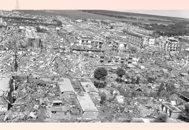
    When those floodwalls and levees breached on August 29, 2005, sea water poured in and became impounded within those topographic bowls, a deadly reminder that topography still mattered. Satellite images of the flood eerily matched the shape of the undeveloped backswamp in nineteenth-century maps, while those higher areas that were home to the historical city, quite naturally, remained dry.

    But the stark geo-topographical history lesson could only go so far in convincing flood victims to move accordingly; after all, they still owned their low-lying properties, and real estate on higher terrain was anything but cheap and abundant. Besides, New Orleanians in general rightfully felt that they had been scandalously wronged by federal engineering failures, and anything short of full metropolitan reconstitution came to be seen as defeatist and unacceptable. Most post-Katrina advocacy thus focused on reinforcing the preexisting technological solutions that kept water out of the lowlands, rather than nudging people toward higher ground. “Shrink the urban footprint” got yelled off the table; “Make Levees, Not War” and “Category-5 Levees Now!” became popular bumper-sticker slogans; and “The Great Footprint Debate” became a bad memory.

    Resettlement in Vertical Space

    The early repopulation of post-Katrina New Orleans defied easy measure. Residents living “between” places as they rebuilt, plus temporarily broken-up families, peripatetic workers, and transient populations all conspired to make the city’s 2006-2009 demographics difficult to estimate, much less map. The 2010 Census finally provided a precise number: 343,829. By 2014, over 384,000 people lived in Orleans Parish, or eighty percent   of the pre-Katrina figure. Of course, not all were here prior; one survey determined roughly 10 percent of the city’s postdiluvian population had not lived here before 2005.8

    How had the new population resettled in terms of topographic elevation? We won’t know precisely until 2020, because only the decennial census provides actual headcounts aggregated at sufficiently high spatial resolution (the block level) for this sort of analysis; annual estimates from the American Community Survey do not suffice. Thus we must make do with the 2010 Census. While much has changed during 2010-2015, the macroscopic settlement geographies under investigation here had largely had fallen into place by 2010.


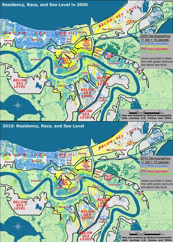
    Figure 1. Residential settlement above and below sea level, 2000 and 2010; analysis and maps by Richard Campanella.

    When intersected with high-resolution LIDAR-based digital elevation models, the 2010 Census data show that residents of metro New Orleans shifted to higher ground by only 1 percent compared to 2000 (Figure 1). Whereas 38 percent of metro-area residents lived above sea level in 2000, 39 percent did so by 2010, and that differentiation generally held true for each racial and ethnic group. Whites shifted from 42 to 44 percent living above sea level; African Americans 33 to 34 percent, Hispanics from 30 to 29 percent, and Asians 20 to 22 percent.

    Clearly, elevation did not exercise much influence in resettlement decisions, and people distributed themselves in vertical space in roughly the same proportions as before the flood. Yet there is one noteworthy angle to the fact that the above-sea-level percentage has risen, albeit barely (38 to 39 percent): it marked the first time in New Orleans history that the percent of people living below sea level has actually dropped.

    What impact did the experience of flooding have on resettlement patterns? Whereas people shifted only slightly out of low-lying areas regardless of flooding, they moved significantly out of areas that actually flooded, regardless of elevation. Inundated areas lost 37 percent of their population between 2000 and 2010, with the vast majority departing after 2005. They lost 37 percent of their white populations, 40 percent of their black populations, and 10 percent of their Asian populations. Only Hispanics increased in the flooded zone, by 10 percent, in part because this population had grown dramatically region-wide, and because members of this population sometimes settled in neighborhoods they themselves helped rebuild.

    The differing figures suggest that while low-lying elevation theoretically exposes residents to the hazard of flooding, the trauma of actually flooding proved to be, sadly, much more convincing.

    Resettlement in Horizontal Space

    Contrasting before-and-after residential patterns in horizontal space may be done through traditional methods such as comparative maps and demographic tables. What this investigation offers is a more singular and synoptical depiction of spatial shifts: by computing and comparing spatial central tendencies, or centroids.  

    A centroid is a theoretical center of balance of a given spatial distribution. A population centroid is that point around which people within a delimited area are evenly distributed.9

    Centroids capture complex shifts of millions of data with a single point. But they do not tell the entire story. A centroid for a high-risk coastal area, for example, may shift inland not because people have moved away from the seashore, but because previous residents decided not to return there. It’s also worth noting it takes a lot to move a centroid, as micro-scale shifts in one area are usually offset by countervailing shifts elsewhere. Thus, apparent minor centroid movements can actually be significant. Following are the centroid shifts for metro New Orleans broken down by racial and ethnic groups (Figures 2 and 3).

    In 2000, five years before the flood, there were 1,006,783 people living within the metro area as delineated for this particular study, of whom 512,696 identified their race as white; 435,353 as black; 25,941 as Asian; and 50,451 as Hispanic in ethnicity. Five years after the flood, these figures had changed to 817,748 total population, of whom 416,232 were white; 327,972 were black; 27,562 were Asian, and 75,397 were Hispanic.10 When their centroids are plotted, they show that metro residents as a whole, and each racial/ethnic sub-group, shifted westward and southward between 2000 and 2010, away from the location of most of the flooding and away from the source of most of the surge, which generally penetrated the eastern and northern (lakeside) flanks of the metropolis.

    Did populations proactively move away from risk? Not quite. What accounts for these shifts is the fact that the eastern half of the metropolis bore the brunt of the Katrina flooding, and the ensuing destruction meant populations here were less likely to reconstitute by 2010, which thus nudged centroids westward. Additionally, flooding from Lake Pontchartrain through ruptures in two of the three outfalls (drainage) canals disproportionally damaged the northern tier of the city, namely Lakeview and Gentilly. Combined with robust return rates in the older, higher historical neighborhoods along the Mississippi, as well as the unflooded West Bank (which sit to the south and west of the worst-damaged areas), they abetted a southwestward shift of the centroids. In a purely empirical sense, this change means more people now live in less-exposed areas. But, as we saw with the vertical shifts, the movements are more a reflection of passive responses to flood damage than active decisions to avoid future flooding.


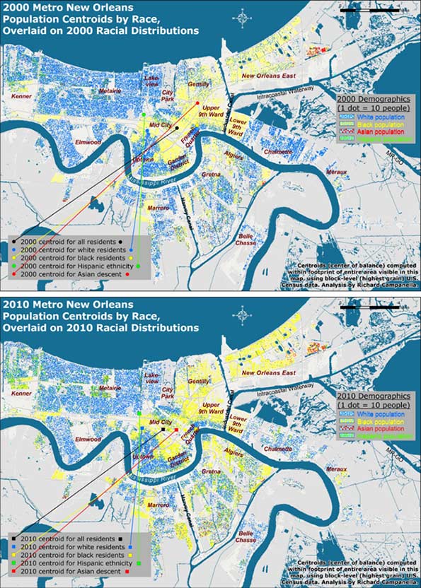
    Figure 2. Population centroids by race and ethnicity for metro New Orleans, 2000-2010; see next figure for detailed view. Analysis and maps by Richard Campanella.


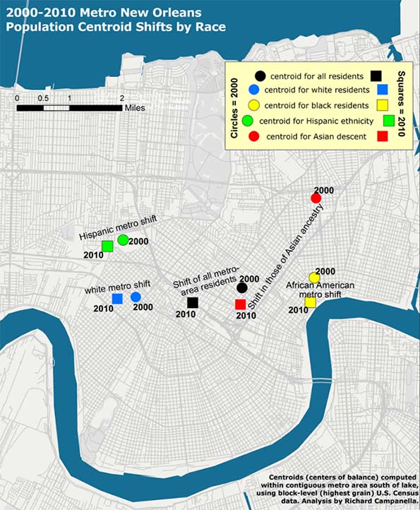
    Figure 3. A closer look at the metro-area population centroid shifts by race and ethnicity, 2000-2010; analysis and map by Richard Campanella.

    Reflections

    Resettlement patterns in metro New Orleans have only marginally reduced residential exposure to the hazard of storm surge. In the vertical dimension, metro-area residents today occupy below-sea-level areas at only a slightly lower rate than before the deluge, 61 percent as opposed to 62 percent, although that change represents the first-ever reverse (decline) of the century-long drift into below-sea-level areas. Likewise, residents’ horizontal shifts, which were in southwestward directions, seemed to suggest a movement away from hazard, but these shifts were more a product of passive than active processes .

    Metro New Orleans, it is important to note, has substantially reduced its overall risk—but mostly thanks to its new and improved federal Hurricane & Storm Damage Risk Reduction System (HSDRRS) rather than shifts in residences. No longer called a “protection” system, the Risk Reduction System is a $14.5 billion integrated network of raised levees, strengthened floodwalls, barriers, gates, and pumps built by the U.S. Army Corps of Engineers and its contractors to protect the metropolis from the surges accompanying storms with a 1-percent chance of occurring in any given year.11 The HSDRRD, which worked well during Hurricane Isaac’s surprisingly strong surge in 2012, has given the metropolis a new lease on life, at least for the next few decades. But all other risk drivers—the condition of the coastal wetlands, subsidence and sea level rise, social vulnerability, and, as evidenced in this paper, exposure—have either slightly worsened, only marginally improved, or generally remained constant.

    The exposure-related patterns reported here reflect who won the “Great Footprint Debate” ten years ago.12 Months after Katrina, when it became clear that no neighborhoods would be closed and the urban footprint would persist, decisions driving resettlement patterns in the flooded region effectively transferred from leaders to homeowners. Rather inevitably, the laissez faire rebuilding strategy proved to be exactly that, and people generally repopulated areas they had previously occupied, though at markedly varied densities.

    Ten years later, the resulting patterns are a veritable Rorschach Test. Some observers look to the 75-90 percent repopulation rates of certain flooded neighborhoods and view them as heroically high, proof of New Orleanians’ resilience and love-of-place. Others point to the 25-50 percent rates of other areas and call them scandalously low, evidence of corruption and ineptitude. Still others might point to the thousands of scattered blighted properties and weedy lots and concede—as St. Bernard Parish President David Peralta admitted on the ninth anniversary of Hurricane Katrina—that “we probably should have shrunk the footprint of the parish at the very beginning.”13

    As for the HSDRRS, continual subsidence and erosion vis-à-vis rising seas, coupled with costly and as-yet undetermined maintenance and certification responsibilities, will gradually diminish the safety dividend provided by this remarkable system. The nation’s willingness to pay for continued upkeep, meanwhile, may grow tenuous; indeed, it’s not even a safe bet locally. Voters in St. Bernard Parish, which suffered near-total inundation from Katrina, defeated not once but twice a tax to pay for drainage and levee maintenance, a move that may well increase flood insurance rates.14

    Residents throughout the metropolis appear to be repeating the same mistakes they made during the twentieth century: of dismissing the importance of natural elevation, of over-relying on engineering solutions, of under-maintaining these structures in a milieu of scarce funds, and of developing a false sense of security about flood “protection.”

    We need to recognize the limits of our ability to neutralize hazards—that is, to presume that levees will completely protect us from storm surges—while appreciating the benefits of reducing our exposure to them. Beyond the metropolis, this means aggressive coastal restoration using every means available as soon as possible, an effort that may well require some expropriations. Within the metropolis, it means living on higher ground or otherwise mitigating risk. In the words of University of New Orleans disaster expert Dr. Shirley Laska, “mitigation, primarily elevating houses, is [one] way to achieve the affordable flood insurance…. It is possible to remain in moderately at-risk areas using engineered mitigation efforts, combined with land use planning that restricts development in high-risk areas.”15

    Planning that restricts development in high-risk areas: this was the same reasoning behind the “shrink the urban footprint” argument of late 2005—and anything but the laissez faire strategy that ensued.

    Bio
    Richard Campanella, a geographer with the Tulane School of Architecture, is the author of “Bienville’s Dilemma,” “Geographies of New Orleans,” “Delta Urbanism,” “Bourbon Street: A History,” and other books. His articles may be read at http://richcampanella.com , and he may be reached at rcampane@tulane.edu or @nolacampanella on Twitter.

    Acknowledgements
    The author wishes to thank Gulf of Mexico Program Officer Kristin Tracz of the Walton Family Foundation, Dr. Shirley Laska, and the Gulf Coast Restoration Fund at New Venture Fund, and Tulane School of Architecture, as well as Garry Cecchine, David Johnson, and Mark Davis for their reviews.

    1 David Crichton, “The Risk Triangle,” in Natural Disaster Management, edited by J. Ingleton (Tudor Rose, London, 1999), pp. 102-103.

    2 In this paper, “metro New Orleans” means the conurbation (contiguous urbanized area shown in the maps) of Orleans, Jefferson, western St. Bernard, and upper Plaquemines on the West Bank (Belle Chasse); it excludes the outlying rural areas of these parishes, such as Lake Catherine, Grand Island, and Hopedale, and does not include the North Shore or the river parishes.

    3 Brad Pitt, as cited in “Make It Right—History,” http://makeitright.org/about/history/, visited February 13, 2015.

    4 Richard Campanella, Bienville’s Dilemma: A Historical Geography of New Orleans and Geographies of New Orleans (University of Louisiana Press, 2006, 2008); R. Campanella, Delta Urbanism: New Orleans (American Planning Association, 2010); R. Campanella, “The Katrina of the 1800s Was Called Sauve’s Crevasse,” Times-Picayune, June 13, 2014, and other prior works by the author.

    5 H. W. Gilmore, Some Basic Census Tract Maps of New Orleans (New Orleans, 1937), map book stored at Tulane University Special Collections, C5-D10-F6.

    6 Richard Campanella, Bienville’s Dilemma: A Historical Geography of New Orleans (University of Louisiana Press, 2008) and other prior works by the author.

    7 Coincidently, 38 percent of all residents of the contiguous metropolis south of Lake Pontchartrain also lived above sea level in 2000. Thus, at both the city and metropolitan level, three out of every eight residents lived above sea level and the other five resided below sea level. All figures calculated by author using highest-grain available historical demographic data, usually from the U.S. Census, and LIDAR-based high-resolution elevation data captured in 1999-2000 by FEMA and the State of Louisiana.

    8 Henry J. Kaiser Family Foundation, “New Orleans Five Years After the Storm: A New Disaster Amid Recovery” (2010), http://kaiserfamilyfoundation.files.wordpress.com/2013/02/8089.pdf

    9 Defining the study area is essential when reporting centroids. New Orleans proper, the contiguous metro area, and the Metropolitan Statistical Area, which includes St. Tammany and other outlying parishes, would all have different population centroids. This study uses the metro area south of the lake shown in the accompanying maps. It is also important to use the finest-grain—that is, highest spatial resolution—demographic data to compute centroids, as coarsely aggregated data carries with it a wider margin of error. This study uses block-level data from the decennial U.S. Census, the finest available.

    10 Figures do not sum to totals because some people chose two or more racial categories while others declined the question, and because Hispanicism is viewed by the Census Bureau as an ethnicity and not a race.

    11 For details on this system, see http://www.mvn.usace.army.mil/Missions/HSDRRS.aspx

    12 Richard Campanella, Bienville’s Dilemma: A Historical Geography of New Orleans (University of Louisiana Press, 2008), pp. 344-355.

    13 David Peralta, as quoted by Benjamin Alexander-Bloch, “Hurricane Katrina +9: Smaller St. Bernard Parish Grappling with Costs of Coming Back,” Times-Picayune/NOLA.COM, August 29, 2014.

    14 Mark Schleifstein, “St. Bernard Tax Defeat Means Higher Flood Risk, Flood Insurance Rates, Levee Leaders Warn,” Times-Picayune/NOLA.COM, May 4, 2015, http://www.nola.com/environment/index.ssf/2015/05/st_bernard_tax_defeat_means_hi.html ; see also Richard Campanella, “The Great Footprint Debate, Updated,” Times-Picayune/NOLA.COM, May 31, 2015.

    15 Shirley Laska, email communication with author, April 12, 2015.

  • Countering Progressives’ Assault on Suburbia

    The next culture war will not be about issues like gay marriage or abortion, but about something more fundamental: how Americans choose to live. In the crosshairs now will not be just recalcitrant Christians or crazed billionaire racists, but the vast majority of Americans who either live in suburban-style housing or aspire to do so in the future. Roughly four in five home buyers prefer a single-family home, but much of the political class increasingly wants them to live differently.

    Theoretically, the suburbs should be the dominant politically force in America. Some 44 million Americans live in the core cities of America’s 51 major metropolitan areas, while nearly 122 million Americans live in the suburbs. In other words, nearly three-quarters of metropolitan Americans live in suburbs.

    Yet it has been decided, mostly by self-described progressives, that suburban living is too unecological, not mention too uncool, and even too white for their future America. Density is their new holy grail, for both the world and the U.S. Across the country efforts are now being mounted—through HUD, the EPA, and scores of local agencies—to impede suburban home-building, or to raise its cost. Notably in coastal California, but other places, too, suburban housing is increasingly relegated to the affluent.

    The obstacles being erected include incentives for density, urban growth boundaries, attempts to alter the race and class makeup of communities, and mounting environmental efforts to reduce sprawl. The EPA wants to designate even small, seasonal puddles as “wetlands,” creating a barrier to developers of middle-class housing, particularly in fast-growing communities in the Southwest. Denizens of free-market-oriented Texas could soon be experiencing what those in California, Oregon and other progressive bastions have long endured: environmental laws that make suburban development all but impossible, or impossibly expensive. Suburban family favorites like cul-de-sacs are being banned under pressure from planners.

    Some conservatives rightly criticize such intrusive moves, but they generally ignore how Wall Street interests and some developers see forced densification as opportunities for greater profits, often sweetened by public subsidies. Overall, suburban interests are poorly organized, particularly compared to well-connected density lobbies such as the developer-funded Urban Land Institute (ULI), which have opposed suburbanization for nearly 80 years. 

    The New Political Logic

    The progressives’ assault on suburbia reflects a profound change in the base of the Democratic Party. As recently as 2008, Democrats were competitive in suburbs, as their program represented no direct threat to residents’ interests. But with the election of Barack Obama, and the continued evolution of urban centers as places with little in the way of middle-class families, the left has become increasingly oriented towards dense cities, almost entirely ruled by liberal Democrats.

    Obama’s urban policies are of a piece with those of “smart growth” advocates who want to curb suburban growth and make sure that all future development is as dense as possible.  Some advocate radical measures such as siphoning tax revenues from suburbs to keep them from “cannibalizing” jobs and retail sales. Some even fantasize about carving up the suburban carcass, envisioning three-car garages “subdivided into rental units with street front cafés, shops and other local businesses” while abandoned pools would become skateboard parks.

    At the end of this particular progressive rainbow, what will we find? Perhaps something more like one sees in European cities, where the rich and elite cluster in the center of town, while the suburbs become the “new slums” that urban elites pass over on the way to their summer cottages.

    Political Dangers

    The abandonment of the American Dream of suburban housing and ownership represents a repudiation of what Democrats once embraced and for which millions, including many minorities, continue to seek out. “A nation of homeowners,” Franklin D. Roosevelt asserted, “of people who own a real share in their land, is unconquerable.”

    This rhetoric was backed up by action. It was FDR, and then Harry Truman, who backed the funding mechanisms—loans for veterans, for example—that sparked suburbia’s growth. Unlike today’s progressives, the old school thought it good politics to favor those things that most people aspire to achieve. Democrats gained ground in the suburbs, which before 1945 had been reliably and overwhelmingly Republican.

    Even into the 1980s and beyond, suburbanites functioned less as a core GOP constituency than as the ultimate swing voters. As urban cores became increasingly lock-step liberal, and rural Democrats slowlyfaded towards extinction, the suburbs became the ultimate contested territory. In 2006, for example, Democrats won the majority of suburban voters. In 2012, President Obama did less well than in 2008, but still carried most inner and mature suburbs while Romney trounced him in the farther out exurbs. Overall Romney eked out a small suburban margin.

    Yet by 2014, as the Democratic Party shifted further left and more urban in its policy prescriptions, these patterns began to turn.  In the 2014 congressional elections, the GOP boosted its suburban edge to 12 percentage points. The result was a thorough shellacking of the Democrats from top to bottom. 

    Will demographics lead suburbs to the Democrats?

    Progressive theory today holds that the 2014 midterm results were a blast from the suburban past, and that the  key groups that will shape the metropolitan future—millennials and minorities—will embrace ever-denser, more urbanized environments. Yet in the last decennial accounting, inner cores gained 206,000 people, while communities 10 miles and more from the core gained approximately 15 million people.

    Some suggest that the trends of the first decade of this century already are passé, and that more Americans are becoming born-again urbanistas. Yet after a brief period of slightly more rapid urban growth immediately following the recession, U.S. suburban growth rates began to again surpass those of urban cores. An analysis by Jed Kolko, chief economist at the real estate website Trulia, reports that between 2011 and 2012 less-dense-than-average Zip codes grew at double the rate of more-dense-than-average Zip codes in the 50 largest metropolitan areas. Americans, he wrote, “still love the suburbs.”

    What is also missed by the Obama administration and its allies is the suburbs’ growing diversity. If HUD wants to start attacking these communities, many of their targets will not be whites, but minorities, particularly successful ones, who have been flocking to suburbs for well over a decade.

    This undermines absurd claims that the suburbs need to be changed in order to challenge the much detested reign of “white privilege.” In reality, African-Americans have been deserting core cities for years, largely of their own accord and through their own efforts: Today, only 16 percent of the Detroit area’s blacks live within the city limits.

    These trends can also be seen in the largely immigrant ethnic groups. Roughly 60 percent of Hispanics and Asians, notes the Brooking Institution, already live in suburbs. Between the years 2000 and 2012, the Asian population in suburban areas of the nation’s 52 biggest metro areas grew by 66 percent, while that in the core cities expanded by 35 percent. Of the top 20 areas with over 50,000 in Asian population, all but two are suburbs.

    Left to market forces and natural demographic trends, suburbs are becoming far more diverse than many cities, meaning that in turning on suburbia, progressives are actually stomping on the aspirations not just of privileged whites but those of many minorities who have worked hard to get there.

    Another huge misreading of trends relates to another key Democratic constituency, the millennial generation.  Some progressives have embraced the dubious notion that millennials won’t buy cars or houses, and certainly won’t migrate to the suburbs as they marry and have families. But those notions are rapidly dissolving as millennials do all those things. They are even—horror of horrors!—shopping atWal-Mart, and in greater percentages than older cohorts.

    Moreover, notes Kolko, millennials are not moving to the denser inner ring suburban areas. They are moving to the “suburbiest” communities, largely on the periphery, where homes are cheaper, and often schools are better. When asked where their “ideal place to live,” according to a survey by Frank Magid and Associates, more millennials identified suburbs than previous generations. Another survey in the same year, this one by the Demand Institute, showed similar proclivities.

    Stirrings of Rebellion

    So if the American Dream is not dead among the citizens, is trying to kill it good politics? It’s clear that Democratic constituencies, notably millennials, immigrants and minorities, and increasingly gays—particularly gay couples—are flocking to suburbs. This is true even in metropolitan San Francisco, where 40 percent of same-sex couples live outside the city limits.

    One has to wonder how enthusiastic these constituents will be when their new communities are “transformed” by federal social engineers. One particularly troubling group may be affluent liberals in strongholds such as Marin County, north of San Francisco, long a reliable bastion of progressive ideology.

    Forced densification–the ultimate goal of the “smart growth” movement—also has inspired opposition in Los Angeles, where densification is being opposed in many neighborhoods, as well as traditionally more conservative Orange Country. Similar opposition has arisen in Northern Virginia suburbs, another key Democratic stronghold.

    These objections may be dismissed as self-interested NIMBYism, but this misses the very point about why people move to suburbs in the first place. They do so precisely in to avoid living in crowded places. This is not anti-social, as is alleged, but an attempt—natural in any democracy—to achieve a degree of self-determination, notes historian Nicole Stelle Garrett.

    Aroused by what they perceive as threats to their preferred way of life, these modern pilgrims can prove politically effective. They’ve shown this muscle while opposing plans not only to increase the density in suburbs, and also balking at the shift of transportation funding from roads, which suburbanites use heavily, to rail transit. This was seen in Atlanta in 2012 when suburban voters rejected a mass transit plan being pushed by downtown elites and their planning allies. Opposition to expanding rail service has also surfaced in the Maryland suburbs of Washington.

    Suburbs and 2016 Election

    To justify their actions against how Americans prefer to live, progressives will increasingly cite the environment. Climate change has become the “killer app” in the smart growth agenda and you can expect the drumbeat to get ever louder towards the Paris climate change conference this summer.

    Yet the connection between suburbs and climate is not as clear as the smart growth crowd suggests.  McKinsey and other studies found no need to change housing patterns to reduce greenhouse gases, particularly given improvements in both home and auto efficiency. Yet so great is their animus that many anti-suburban activists seem to prefer stomping on suburban aspirations rather seeking ways to make them more environmental friendly.

    As for the drive to undermine suburbs for reasons of class, in many ways the  assault on suburbia is, in reality,  a direct assault on our most egalitarian geography. An examination of American Community Survey Data for 2012 by the University of Washington’s Richard Morrill indicates that the less dense suburban areas tended to have “generally less inequality” than the denser core cities; Riverside-San Bernardino, for example, is far less unequal than Los Angeles; likewise, inequality is less pronounced in Sacramento than San Francisco. Within the 51 metropolitan areas with more than 1 million people, notes demographer Wendell Cox, suburban areas were less unequal (measured by the GINI Coefficient) than the core cities in 46 cases.

    In the coming year, suburbanites should demand more respect from Washington, D.C., from the media, the political class and from the planning community. If people choose to move into the city, or favor density in their community, fine. But the notion that it is the government’s job to require only one form of development contradicts basic democratic principles and, in effect, turns even the most local zoning decision into an exercise in social engineering.

    As America’s majority, suburbanites should be able to deliver a counterpunch to those who seem determined to destroy their way of life. Irrespective of race or generation, those who live in the suburbs—or who long to do so—need to understand the mounting threat to their aspirations  Once they do, they could spark a political firestorm that could reshape American politics for decades to come.

    This piece first appeared at Real Clear Politics.

    Joel Kotkin is executive editor of NewGeography.com and Roger Hobbs Distinguished Fellow in Urban Studies at Chapman University, and a member of the editorial board of the Orange County Register. He is also executive director of the Houston-based Center for Opportunity Urbanism. His newest book, The New Class Conflict is now available at Amazon and Telos Press. He is also author of The City: A Global History and The Next Hundred Million: America in 2050. He lives in Orange County, CA.

    Suburbs photo courtesy of BigStockPhoto.com.