Category: Suburbs

  • 2010-2012: More Modest Dispersion Within Metropolitan Areas

    American cities seemed to be re-centralizing in the years immediately following the Great Recession, but new American Community Survey data indicates that, contrary to conventional wisdom, Americans continue to disperse though at a much reduced rate. The Census Bureau has just released the five year American Community Survey (2010-2014) small area data used by the City Sector Model to report on population trends within functional sectors of metropolitan areas. The City Sector Model classifies small areas as the urban core, suburban or ex-urban without reference to the more traditional analysis method that relied on core cities and suburbs (Note 1). The principal purpose is to compare finer-grained data and trends in parts of the metropolitan area that are more reflective of pre-World War II urban forms and lifestyles (the Urban Core: CBD and the Urban Core Ring) and the balance of the metropolitan area, which is automobile oriented (the Earlier Suburbs, Later Suburbs and Exurbs).

    These data were collected over a five year period, with the middle year being 2012. General trends can be examined in comparison to the 2008-2012 American Community Survey, with a middle year of 2010. At the same time, caution is warranted since the American Community Survey is not a count, such as is collected in the decennial censuses. For simplicity, this article refers to the 2010 to 2014 data as 2012 and the 2008 to 2012 data as 2010.

    More Modest Dispersion

    The continuing dispersion was most evident in the rising 0.4 percentage point share (from 26.9% to 27.3%) in the Later Suburbs – with mid-point construction dates of 1980 or later. Two of the other four functional city sectors experienced declines in their shares, with the higher density, transit-, walking- and cycling-oriented Urban Core Ring dropping from 13.5% to 13.4% and the Earlier Suburbs dropping from 41.9% to 41.6% of the major metropolitan population. The earlier suburbs are automobile oriented and have houses with median construction dates of 1946 through 1979. The Urban Core CBD sector and the exurbs have retained their previous share of the population since 2010 (Figure: Growth Share by City Sector: 2010-2012 and Population Share by City Sector).

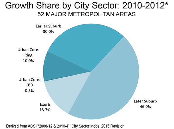
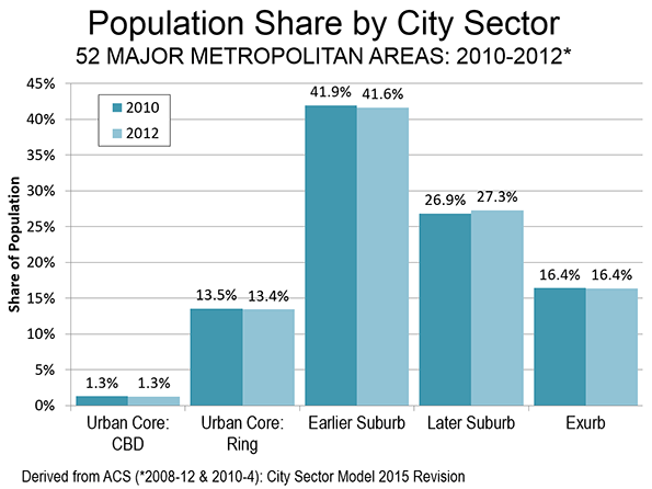
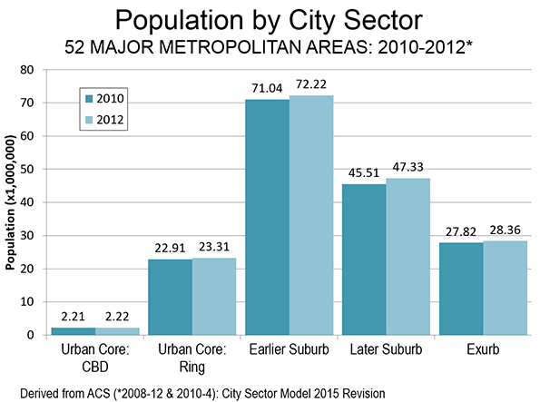
    Overall the Urban Core, which consists of the CBD and Ring dropped from 14.8% of the population to 14.7%. If this rate were to continue through the 2020 census, the Urban Core share of the major metropolitan area population would drop by 0.5 percentage points, considerably less than the 1.7 percentage point loss between 2000 and 2010. Nonetheless, the suburbs and exurbs accounted for nearly 90% of the growth between 2010 and 2012 (Figure: Population by City Sector). Suburbia, even exurbia, is where the growth is

    The new data also suggests that much of that growth was in the suburban areas of the historical core municipalities (newer and automobile oriented). For example, large areas of core cities are functionally suburban, such as in Phoenix, Dallas, Los Angeles, Portland, Atlanta, Charlotte, and elsewhere.

    The bottom line , as we have indicated in previous articles, is this: the data shows virtually no “return to the city.” Between 2010 and 2012 the suburbs and exurbs gained 3.5 million residents, while the Urban Cores gained 400,000. The Exurbs alone gained more population than the Urban Core (CBD and Ring combined). This has also been evident in each year of this decade by the continuing domestic migration to suburban and exurban counties, which has exceeded that of counties that contain the urban cores.

    New York, Other Legacy Cities and the Balance

    There is considerable variation in the size and growth of Urban Cores among the major metropolitan areas. The Urban Cores in the “legacy cities” are far larger and are capturing a far higher share of their metropolitan area growth. The legacy cities are the six metropolitan areas that have downtowns (central business districts or CBD’s) with more than 200,000 jobs (New York, Chicago, Philadelphia, San Francisco, Boston and Washington), These are generally older cities and the strength of their Urban Cores is illustrated by the fact that, combined, the core cities of these metropolitan areas account for 55% of the destinations of transit committing trips in the nation.

    Even among the legacy cities, strong distinctions exist. New York, with central business district employment of nearly 2 million, has nearly 4 times the jobs that of its Chicago counterpart. Indeed, New York’s central business district employment exceeds that of the combined employment in the downtowns other five legacy cities. Thus, as in other indicators of intense urbanism (such as transit ridership and the share of the national transit ridership increase), New York is in a “league” of its own.

    As of 2012, New York’s Urban Core included approximately 53% of the metropolitan area population. This is more than double the 26% share of the metropolitan population in the urban cores of Chicago, Philadelphia, San Francisco, Boston and Washington (Figure Legacy Cities and Others: Population).

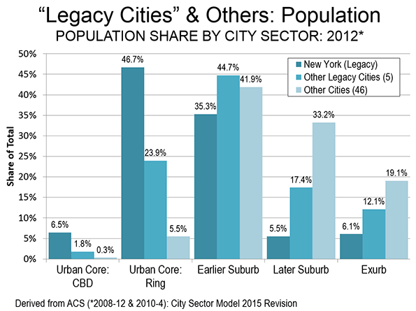
    The difference between the legacy cities and the other 46 metropolitan areas is even more stark. On average, other metropolitan areas have on average only approximately seven percent of their populations in their urban cores, compared to 53 percent in New York and 26 percent in the other five.

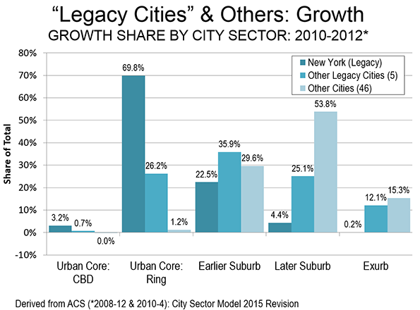
    There are even greater disparities in population growth. Between 2010 and 2012, 73% of the population growth in the New York metropolitan area was in the Urban Core. This is 2.7 times the average 27% of metropolitan growth in the urban cores of the other five legacy cities. Thus, by two measures, population concentration and population growth in the urban cores, Chicago, Boston and the other legacy cities cannot even present themselves as “little New York’s”.

    Most other cities are not even in the same league as Chicago or Boston. None achieved a 20 percent Urban Core growth percentage, though St. Louis was close (19.8 percent), and Seattle was next (15.0 percent). The urban core growth in the other 46 cities was less than 6% (Figure Legacy Cities and Others: Growth). Even in Portland, with its strong densification policies biased toward urban core development and discouraging towards suburban development, no more than average 10% of its growth took place in its Urban Core. Nearly 90 percent of Portland’s growth was in the suburbs and exurbs.

    Back to Normalcy?

    The 2010-2012 data does not indicate a return to the near monopoly on growth enjoyed by the suburbs and exurbs in the 1990s and 2000s. But more recent data suggests stronger suburban performance, as chronicled by William Frey at the Brookings Institution and Jed Kolko at Trulia. At the same time, it is good to see the upward trends in the in the urban cores, which as metropolitan areas as diverse as St. Louis and Seattle show, do not depend on suburban misfortune to prosper. The cores are an important part of a healthy metropolitan system, although in most places they are far smaller in population, and growth, than the suburban rings.

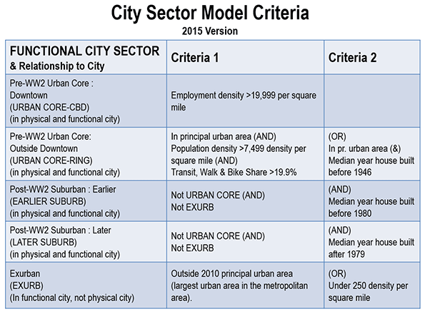
    Note: The “City Sector Model” provides data for areas (Zip Code Analysis Zones) within metropolitan areas, as opposed to data based on jurisdictional boundaries, such as city limits. The data is based on small areas, Zip Code Tabulation Areas (ZCTA’s). The criteria for classification is indicated in the Figure: City Sector Model Criteria.

    Wendell Cox is Chair, Housing Affordability and Municipal Policy for the Frontier Centre for Public Policy (Canada), is a Senior Fellow of the Center for Opportunity Urbanism (US), a member of the Board of Advisors of the Center for Demographics and Policy at Chapman University (California) and principal of Demographia, an international public policy and demographics firm.He is co-author of the "Demographia International Housing Affordability Survey" and author of "Demographia World Urban Areas" and "War on the Dream: How Anti-Sprawl Policy Threatens the Quality of Life." He was appointed to three terms on the Los Angeles County Transportation Commission, where he served with the leading city and county leadership as the only non-elected member. He served as a visiting professor at the Conservatoire National des Arts et Metiers, a national university in Paris.

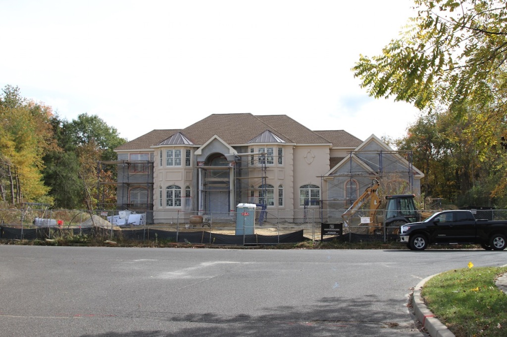
    Photo: New York’s Growing Skyline by Citizen59 (Own work) [CC BY 3.0], via Wikimedia Commons

  • How Portland Is a Lot Like Texas

    One theme I always hammer is that you have to look at proposed policy solutions in the context of the area where you want to apply them.

    A great example of this is Portland’s Urban Growth Boundary (UGB). The UGB, a policy that limits suburban development outside of a line drawn around the Portland region, is widely admired and perhaps even seen a type of holy grail policy in terms of preventing sprawl.

    Obviously restricting development outside the UGB raised demand for land inside of it and thus housing prices. Portland’s median home price multiple – that is, the median home price divided by the median household income – is 4.8. The average household in Portland would need to spend 4.8 times its annual income to buy a house there.  This compares with 2.9 in Kansas City, 3.0 in Columbus, and 3.9 in Austin.

    So Portland is less affordable than many similar sized housing markets around the US.

    But despite this, Portland remains the most affordable major West Coast metro area.  That’s because housing prices in other major coastal cities are even higher, including Seattle (5.2), Los Angeles (8.0), San Diego (8.3), the Bay Area (9.2), and Vancouver (10.6).

    So even while its home prices have risen, Portland remains the cheapest major city to live apart from Sacramento (4.7).  That is, even with the UGB Portland has a big cost advantage over its regional competition. In short, it’s cheap.

    In this way, the attraction of Portland is a lot like Texas. Its draw is more a cost arbitrage play for people leaving San Francisco than an upgrade to superior urbanism from the interior. As it happens, California refugees make up the bulk of the net migrants into Portland.

    The Texas comparison is relevant on the tax front too. Portland is one of the rare places you have the potential for double border tax arbitrage. Washington state has no income tax and Oregon has no sales tax. While only a limited number of people can take advantage of both (you have to both live and work in Washington to avoid the income tax), being able to zero out one or more major tax categories is a win.

    This is not to say that Portland is a lousy place to live. It’s fantastic as near as I can tell. The point is that Portland was able to put in place policies to create good enough urbanism to lure a certain number of San Franciscans without compromising its competitive position because it was in a high cost neighborhood.

    The story would be very different for a place like Oklahoma City or Columbus. These cities are in low cost regions, and if they undertook policies that raised their housing prices, they’d rapidly find themselves the most expensive market in their area.

    Cloning Portland’s UGB is simply not a viable policy for most interior cities, even if they had the political alignment to make it happen.

    There are many policies that can be broadly implemented across cities. The general principle is to first understand why a policy worked in the original context, then ask whether it is applicable to the target context, and if so how to implement it most successfully.

    Aaron M. Renn is a senior fellow at the Manhattan Institute and a Contributing Editor at City Journal. He writes at The Urbanophile, where this piece originally appeared.

  • The Detached iHome of the Future

    Will new American housing growth continue to reflect old methods, or will the land development, home building, and consulting industry retool, re-educate, and collaborate to create a new era of more attractive, livable, efficient, and environmentally responsible growth at attainable prices?

    Here is why it would be so significant to make a change: The US Department of Housing has determined that 620,000 new single family homes were completed in 2014, averaging 2,453 square feet on an 8,689 square foot average lot. The average price was $345,800, with a national total of $214.4 billion.

    Those post-recession 620,000 homes have used up much of the existing empty suburban lots from the recession. Assume that 30 percent of a development is consumed by infrastructure, and that typical 8,689 square foot lot represents about 12,400 square foot of growth. That means we have newly-developed — or recently consumed — about 275 square miles of construction, using lot stock. In other words, now that the existing lots are consumed, future growth will annually consume more than 275 square miles of land.

    That development, at $214 billion dollars in home value, is the equivalent of a $650 iPhone 6s for every US resident. Unlike the iPhone that is assembled in a minute, though, a single family home is built by craftsmen over many months in a development that takes years to go through the approval and construction process.
    An iPhone is a marvel of technology, representing billions in research and development, and requiring close communication and collaboration between professionals in engineering, materials, software, and manufacturing.

    The design for the $345,800 home and its neighborhood progress at a snail’s pace. Both floor plans and site plans are rooted in the 1960s, with civil engineering standards from the 1950s handbook. The professionals involved in land development design and construction — surveyors, planners, civil engineers, and architects — are a most un-collaborative group, fostering this stagnation.

    Yet today, innovations in both technology and methods can empower the consulting industry to create neighborhoods and housing that matches the progress of other industries, like those that are creating mobile phones, cars, and medicines. Savvy developers and home builders are beginning to break free, setting new trends by merging planning, architecture, and engineering.

    Of those 620,000 homes, it’s likely that only a few custom built ones had a tight coordination between the room function, the wall and window locations, and the connection to the surrounding viewsheds.

    When land is ‘subdivided,’ the streets, and afterwards the lot lines, are all set to regulatory minimums. This method ‘stretches’ the public street to create the greatest volume of street and the smallest area available for lots. The compression of space forces cookie-cutter, mundane growth. Architectural design was traditionally an afterthought to the subdividing process.

    To develop alternative approaches, we used the ‘down-time’ during the recession to research and develop new geometric relationships between lot and home, as well as to develop better spatial analysis and design software to accomplish ‘Architectural Blending’ for the mass market single family home.

    We saw how advancements in land planning have been made possible by merging engineering and surveying geometry with organic site layout methods. This combination has proven to significantly reduce infrastructure (street-utility length), while increasing average lot area. Redistributed space allows for more flexible designs.

    The merging of interior and exterior spaces, ‘Architectural Blending,’ was first implemented in a design idea coined as ‘BayHomes.’ The term came from the bay-like shape of common open spaces that undulated between home fronts. In 1999, Professional Builder Magazine called BayHomes “New Urbanism with a View.”

    BayHomes are single family detached homes set within townhome zoning, thus, they are in association-maintained environments. They were first implemented in 1998 on The Greens of Hutchinson, Minnesota, offering production housing that coordinated living spaces within the home with adjacent spaces and views, and for the first time merged planning and architecture at attainable prices. Since The Greens, there have been thousands of BayHome designs that have refined the method.

    BayHomes are positioned to provide a panoramic view from the focal point, usually the kitchen, to common spaces adjacent to the home front. BayHomes hide the garages, which makes them ideal along arterial streets to create a ‘village-like’ appearance. By eliminating most of the public street right-of-ways, compared to traditional single family homes the BayHome can achieve duplex density with plenty of landscaped open space providing a lower density feel.

    BayHomes serve a specific consumer who would have otherwise bought a duplex or townhome. The large scale housing market has been and will remain single family homes.

    The next problem became: How to duplicate advantages of a BayHome in a single family home which must front a lot on a public street? The challenge to increase available space was solved through a design technique called coving. A rectangular lot is simple: You have few options — no side views and limited front and rear yards space — whereas ‘coving’ produces a larger, non-rectangular lot, yet still maintains the density of the rectangle.

    When we looked at some traditional designs that would fit on higher density narrow lots, we saw typical floor layouts where — for example — 8.1 percent of the home was consumed by the hallway. If the home cost $200,000, then $16,000 was the cost of the hall. By merging planning and architecture, new models are more efficient within higher density single family-home neighborhoods, reducing or eliminating these common forms of waste within and around the home.

    With a new era of design we can solve problems like these, as well as critical issues. The problem with increased density is the compaction of space, sacrificing livability, efficiency, curb appeal, views, and environment. Some may argue that the environment is not harmed by increased density, ignoring that while the lot and home size is reduced, streets, walks, garages, and other infrastructure elements remain the same size as larger lots. Thus, the ratio of housing footprint to paved areas serving the home increases, and ‘organic’ (landscaped) space is sacrificed.

    As the home buying public becomes aware that it’s possible to have a home of significantly higher value than the typical monotonous design rooted in the 1960s, and that it can be located in a neighborhood of greater character, they will demand change with their pocketbooks. They will be able to look at the streetscapes of nearby cookie cutter subdivisions, and see that neighborhoods of the same density can have a dramatic increase in function, curb appeal, views, safety, efficiency, connectivity, and perception of space. The differences will be as dramatic as comparing a dial phone of the 1960s to the iPhone of today.

    Rick Harrison is President of Rick Harrison Site Design Studio and Neighborhood Innovations, LLC. He is author of Prefurbia: Reinventing The Suburbs From Disdainable To Sustainable and creator of Performance Planning System. His websites are rhsdplanning.com and performanceplanningsystem.com.

    Aerial view of Transoma, a community planned on the principles of coving, from the author.

  • Cherry Hill: The Winners

    This is Cherry Hill. It is by far the most desirable suburb in this part of southern New Jersey as measured by all the usual metrics. Property values are high. Public schools are great. The municipal government is lean and responsive. This is as good as the American Dream gets.


    Screen Shot 2015-11-17 at 2.50.46 PM

    Screen Shot 2015-11-17 at 2.51.14 PM

    Screen Shot 2015-11-17 at 2.52.55 PM


    Screen Shot 2015-11-17 at 2.52.03 PM

    Screen Shot 2015-11-17 at 2.50.22 PM

    Screen Shot 2015-11-17 at 3.06.03 PM

    Screen Shot 2015-11-17 at 3.06.42 PM

    Screen Shot 2015-11-17 at 3.05.02 PM

    Screen Shot 2015-11-17 at 3.11.13 PM

    The families who live here are overwhelmingly well educated professionals, often first and second generation immigrants who have discovered the high quality of life on offer. What was once a nearly 100% white enclave is now a diverse multi-cultural community. You’re just as likely to live next door to Hindus, Jews, Greek Orthodox, or Muslims, as the main line Protestants that dominated the area in previous decades. When proponents of suburban living talk about the success of the suburban development pattern this is the kind of place they often refer to.

    Screen Shot 2015-11-17 at 2.56.58 PM

    Screen Shot 2015-11-17 at 2.55.15 PM

    Screen Shot 2015-11-17 at 2.56.28 PM

    Screen Shot 2015-11-17 at 2.55.44 PM

    If you’re raising children you really can’t ask for a better environment. It’s safe, clean, and (most importantly) your kids will rub shoulders with the kids of equally successful families – which is what exclusive suburbs and premium school districts are really all about. Cherry Hill has successfully filtered out the riffraff.

    Screen Shot 2015-11-17 at 4.09.10 PM

    Screen Shot 2015-11-17 at 4.26.18 PM

    Cherry Hill has a middle-of-the-road population when it comes to social issues, but it’s decidedly conservative when it comes to money. It has embraced all the usual cost savings techniques to keep the budget tight and taxes as low as possible. Traditional in-house departments have been dissolved in favor of contract services with low cost private firms for things like waste management, school buses, and landscaping. Sales tax revenue has been boosted by cultivating the most successful regional shopping mall in the area. Class A suburban office parks deliver commercial property taxes to help subsidize the shortfall from residential taxes.

    Screen Shot 2015-11-17 at 4.08.41 PM

    And yet… there are problems. The average homeowner in Cherry Hill pays about $8,000 a year in property tax. Some of the larger homes pictured above pay on the order of $23,000 a year. You can blame teachers and cops and their “extravagant” salaries and pensions, but schools and public safety are the primary attractions to living in Cherry Hill. Outsourcing to low wage alternatives for these public services may not really work over the long term – although Cherry Hill keeps pushing that envelope. And the cost of maintaining a huge amount of very expensive attenuated public infrastructure like roads, sewers, and water pipes is rapidly getting out of control.

    Screen Shot 2015-11-17 at 3.59.48 PM

    Screen Shot 2015-11-17 at 5.54.35 PM

    Screen Shot 2015-11-17 at 5.54.06 PM

    Here’s another problem with Cherry Hill. This is what passes for the public realm. All the emphasis has been placed on private space. The homes, the tree lined subdivisions, the quality retail establishments, and the hermetically sealed professional centers are pristine. But in between there’s nothing that even comes close to a pleasant commons. Route 70 is “Main Street.” That’s all you get. Of course, the people who self select in to Cherry Hill don’t care. They’re inside their homes, shops, offices, and cars 100% of the time. There’s simply no need for a public realm. It’s a fully private pay-per-view environment.

    Screen Shot 2015-11-17 at 4.01.15 PM

    Screen Shot 2015-11-17 at 3.59.17 PM

    Screen Shot 2015-11-17 at 3.50.30 PM

    Screen Shot 2015-11-17 at 4.10.16 PM

    Screen Shot 2015-11-17 at 4.13.11 PM

    Unless you’re one of these poor bastards standing on the side of the highway waiting for a bus that may or may not arrive sometime within the next hour. These people can’t afford to live in Cherry Hill or own private vehicles so they commute on crappy inadequate public transit to and from neighboring low income suburbs.

    Cherry Hill is a giant wealth sponge. It soaks up the segment of the population that can afford to live the best version of a suburban life. That means there are many other suburbs – the vast majority – that become the also-ran towns of fair-to-middling suburbs with just-okay schools and mediocre shops. And then there are the lower income suburbs farther out that can’t quite manage to bootstrap themselves up above the poverty line.

    The dominant conversation in America today centers on the bleakness of inner city ghettos and the extravagance of newly gentrified urban elite neighborhoods. The reality is that most Americans live in the suburbs. A small number of people live in a few great places like Cherry Hill. The overwhelming bulk of the population, including the poor and large downwardly mobile middle class, now live in failing cheap anonymous declining suburbs that no one talks about – until they erupt Ferguson style.

    I’m just sayin.

    John Sanphillippo lives in San Francisco and blogs about urbanism, adaptation, and resilience at granolashotgun.com. He’s a member of the Congress for New Urbanism, films videos for faircompanies.com, and is a regular contributor to Strongtowns.org. He earns his living by buying, renovating, and renting undervalued properties in places that have good long term prospects. He is a graduate of Rutgers University.

  • So Much For The Death Of Sprawl: America’s Exurbs Are Booming

    It’s time to put an end to the urban legend of the impending death of America’s suburbs. With the aging of the millennial generation, and growing interest from minorities and immigrants, these communities are getting a fresh infusion of residents looking for child-friendly, affordable, lower-density living.

    We first noticed a takeoff in suburban growth in 2013, following a stall-out in the Great Recession. This year research from Brookings confirms that peripheral communities — the newly minted suburbs of the 1990s and early 2000s — are growing more rapidly than denser, inner ring areas.

    Peripheral, recent suburbs accounted for roughly 43% of all U.S. residences in 2010. Between July 2013 and July 2014, core urban communities lost a net 363,000 people overall, Brookings demographer Bill Frey reports, as migration increased to suburban and exurban counties. The biggest growth was in exurban areas, or the “suburbiest” places on the periphery.

    How could this be? If you read most major newspapers, or listened to NPR or PBS, you would think that the bulk of American job and housing growth was occurring closer to the inner core. Yet more than 80% of employment growth from 2007 to 2013 was in the newer suburbs and exurbs. Between 2012 and 2015, as the economy improved, occupied suburban office space rose from 75% of the market to 76.7%, according to the real estate consultancy Costar.

    These same trends can be seen in older cities as well as the Sun Belt. Cities such as Indianapolis and Kansas City have seen stronger growth in the suburbs than in the core.

    This pattern can even be seen in California, where suburban growth is discouraged by state planning policy but seems to be proceeding nevertheless. After getting shellacked in the recession, since 2012 the Inland Empire — long described as a basket case by urbanist pundits — has logged more rapid population growth  than either Los Angeles and even generally healthy Orange County. Last year the metro area ranked third in California for job growth, behind suburban Silicon Valley and San Francisco.

    To those who have been confidently promoting a massive “return to the city,” the resurgence of outer suburbs must be a bitter pill. In 2011, new urbanist pundit Chris Leinberger suggested outer ring suburbs were destined to become “wastelands” or, as another cheerily described them, “slumburbs” inhabited by the poor and struggling minorities chased out of the gentrifying city.

    In this worldview, “peak oil” was among the things destined to drive people out of the exurbs . So convinced of the exurbs decline that some new urbanists were already fantasizing that suburban three-car garages would be “subdivided into rental units with street front cafés, shops, and other local businesses,” while abandoned pools would become skateboard parks.

    This perspective naturally appeals to people who write most of our urban coverage from such high-density hot spots as Brooklyn, Manhattan, Washington, D.C., or San Francisco. And to be sure, all these places continue to attract bright people and money from around the world. Yet for the vast majority, particularly families, such places are too expensive, congested and often lack decent public schools. For those who can’t afford super-expensive houses and the cost of private education, the suburbs, particularly the exurbs, remain a better alternative.

    Even as Houston, like other Sun Belt cities, has enjoyed something of a renaissance in its inner core, nearly 80% of the metro area’s new homebuyers last year purchased residences outside Beltway 8, which is far to west of the core city.

    If you want to know why people move to such places, you can always ask them. On reporting trips to places like Irvine, California, Valencia, north of Los Angeles, or Katy, out on the flat Texas prairie 31 miles west of Houston, you get familiar answers: low crime, good schools and excellent access to jobs. Take Katy’s Cinco Ranch. Since 1990, the planned community has grown to 18,000 residents amid a fourfold expansion in the population of the Katy area to 305,000.

    To some, places like Cinco Ranch represents everything that is bad about suburban sprawl, with leapfrogging development that swallows rural lands and leaves inner city communities behind. Yet to many residents, these exurban communities represent something else: an opportunity to enjoy the American dream, with good schools, nice parks and a thriving town center.

    Nor is this a story of white flight. Roughly 40% of the area’s residents are non-Hispanic white; one in five is foreign born, well above the Texas average. Barely half of the students at the local high school are Caucasian and Asian students have been the fastest-growing group in recent years, with their parents attracted to the high-performing schools.

    “We have lived in other places since we came to America 10 years ago,” says Pria Kothari, who moved to Cinco with her husband and two children in 2013. “We lived in apartments elsewhere in big cities, but here we found a place where we could put our roots down. It has a community feel. You walk around and see all the families. There’s room for bikes –that’s great for the kids.”

    Here Come The Millennials

    Potentially, the greatest source of exurban and peripheral revival lies with the maturation of the millennial generation. Millennials — born between 1982 and 2002 — are widely portrayed as dedicated city dwellers. That a cohort of young educated, affluent people should gravitate to urban living is nothing new. The roughly 20% who, according to an analysis by demographer Wendell Cox, live in urban cores may be brighter, and certainly more loquacious, than their smaller town counterparts, dominating media coverage of millennials. But the vast majority of millennials live elsewhere — and roughly 90% of communities’ population growth that can be attributed to millennials since 2000 has taken place outside of the urban core.

    To be sure, millennials are moving to the suburbs from the city at a lower rate than past generations , but this is more a reflection of slower maturation and wealth accumulation.

    According to U.S. Census Bureau data released last month, 529,000 Americans ages 25 to 29 moved from cities out to the suburbs in 2014 while 426,000 moved in the other direction. Among younger millennials, those in their early 20s, the trend was even starker: 721,000 moved out of the city, compared with 554,000 who moved in.

    This may well reflect rising cost pressures, as well as lower priced housing many millennials can afford. Three-quarters, according to one recent survey, want a single-family house, which is affordable most often in the further out periphery.

    Future trends are likely to be shaped by an overlooked fact: as people age, they change their priorities. As the economist Jed Kolko has pointed out, the proclivity for urban living peaks in the mid to late 20s and drops notably later. Over 25% of people in their mid-20s, he found, live in urban neighborhoods; but by the time they move into their mid-30s, it drops to 18% or lower. In 2018, according to Census estimates, the number of millennials entering their 30s will be larger than those in their 20s, and the trend will only get stronger as the generation ages.

    Some might argue that millennials will be attracted to more urban suburbs, places like Bethesda, Md.; Montclair, N.J.; or the West University or Bellaire areas of Houston, all of them located near major employment centers with many amenities. These suburban areas are also among the most expensive areas in the country, with home prices often in the millions. And a number of older inner ring suburbs, as we saw in the case of Ferguson, are troubled and have lost population — even as the number of residents in downtown areas have grown.

    So when millennials move they seem likely to not move to the nice old suburbs, or the deteriorating one, but those more far-flung suburban communities that offer larger and more affordable housing, good schools, parks and lower crime rates.

    Among the research that confirms this is a study released this year by the Urban Land Institute, historically hostile to suburbs, which found that some 80% of current millennial homeowners live in single-family houses and 70% of the entire generation expects to be living in one by 2020.

    The Future Of Exurbia

    Far from being doomed, exurbia is turning into something very different from the homogeneous and boring places portrayed in media accounts. For one thing exurbs are becoming increasingly ethnically diverse. In the decade that ended in 2010 the percentage of suburbanites living in “traditional” largely white suburbs fell from 51% to 39%.  According to a 2014 University of Minnesota report, in the 50 largest U.S. metropolitan areas, 44% of residents live in racially and ethnically diverse suburbs, defined as between 20% and 60% non-white.

    And how about the seniors, a group that pundits consistently claim to be heading back to the city? In reality, according to an analysis of Census data, as seniors age they’re increasingly unlikely to move, but if they do, they tend to move out of urban cores as they reach their 60s, and to less congested, often more affordable areas out in the periphery. Seniors are seven times more likely to buy a suburban house than move to a more urban location. A National Association of Realtors survey found that the vast majority of buyers over 65 looked in suburban areas, followed by rural locales.

    Trends among millennials, seniors and minorities suggest that demographics are in the exurbs’ favor. The movement to these areas might be accelerated by their growing sophistication, as they build amenities long associated with older cities, such as town centers, good ethnic restaurants and shops, diverse religious institutions and cultural centers. At the same time, the growth of home-based business — already larger than transit ridership in two-thirds of American metropolitan areas and growing much faster — increases the need for larger homes of the sort found most often in the outer rings.

    Rather than regard these communities as outrages to the urban form, planners and developers need to appreciate that peripheral developments remain a necessary part of our evolving metropolitan areas. With a new generation looking for affordable homes, good schools and low crime, it seems logical that many will eventually leave core cities that offer none of the above. The future of exurbia is far from dead; it’s barely begun.

    This piece first appeared at Forbes.

    Joel Kotkin is executive editor of NewGeography.com and Roger Hobbs Distinguished Fellow in Urban Studies at Chapman University, and a member of the editorial board of the Orange County Register. He is also executive director of the Houston-based Center for Opportunity Urbanism. His newest book, The New Class Conflict is now available at Amazon and Telos Press. He is also author of The City: A Global History and The Next Hundred Million: America in 2050. He lives in Orange County, CA.

  • The Houses Americans Choose to Buy

    The US preference for detached housing remains strong, according to the newest data just released in the 2014 American Community Survey, by the United States Census Bureau. In 2014, detached house and represented 82.4 percent of owned housing in the United States. This is   up 1.8 percentage points from the 80.6 percent registered in the 2000 census. The increase may be surprising, given the efforts of planners to steer people into higher density housing, especially apartments.

    The US Situation in 2014

    Among owned housing, mobile homes ranks second only to detached housing. Attached houses, which are ground oriented units with common walls, such as townhomes and semi detached homes (also called duplexes) are the third most popular form of owned housing, accounting for 5.7 percent of units in 2014. Perhaps surprisingly, the apartments planners prefer ranked fourth preference among households buying their own homes. Apartments, which include lower rise, midrise and high-rise condominiums account for 5.5 percent of owned housing. (Figure 1). The fifth, and by far the smallest category of owned housing is "Boats, RVs, Vans, Etc., which represented 0.1 percent of owned housing.

    Trend Since 2000

    There were approximately 4.7 million more detached houses in 2014 than in 2000. This means that 114 percent of the new owned housing stock was detached housing. Despite their second ranking among housing types, there were substantial losses in the number of mobile homes. In 2014 there were approximately 1.1 million fewer mobile homes and continuing losses could drop mobile homes below attached homes and apartments over the next decade. Mobile homes are often transitional for households aspiring to afford detached or even attached housing. Attached homes enjoyed a strong increase of approximately 410,000 units. The strong detached and attached housing increase could reflect, in part, the realization of those aspirations.

    Apartments, which were within 15,000 of attached houses in 2000, dropped to approximately 270,000 behind, while adding only 160,000 owned units. In view of the strong condominium construction rates in some cities, this may be surprising. On the other hand, it could be indicative of the "dark and empty" thesis that many of the new units have been purchased for only occasional use and not as primary residences, some rented out by owners (Figure 2).

    There was an 18,000 unit loss in "Boats, RVs, Vans, Etc."

    Owned Housing by Metropolitan Classification

    The preference for detached housing was pervasive, even in the metropolitan areas with the largest pre-World War II urban cores (identified using the City Sector Model). Nearly 71 percent of owned housing is detached in these metropolitan areas, which include New York, Los Angeles, Chicago, Philadelphia, Washington, Boston and San Francisco. The detached housing percentage rises to 85 percent in the other 46 metropolitan areas with more than 1 million population and is similar for the 53 metropolitan areas between 500,000 and 1 million population. Among the 106 metropolitan areas with more than 500,000 population, the percentage of detached housing increased in 86.

    The detached housing share is a smaller 80 percent outside these largest metropolitan areas.

    The defining difference between the metropolitan areas with the largest cores is in owned apartments, which represent 15 percent of owned housing. This is more than three times the rate of owned apartments in the other 46 major metropolitan areas and the 53 metropolitan areas with between 500,000 and 1,000,000 population (Figure 3).

    Housing Types by Metropolitan Areas

    Among the 106 metropolitan areas, 86 have detached percentages of owned housing of 80 percent or more. The highest detached housing percentage is in Omaha, at 94.8 percent. Modesto trails closely at 94.4 percent. This may not be surprising, since so many households have been driven away from close enough-for-a-long-commute San Francisco Bay Area by its exorbitant house prices and severely constrained housing choices. Detached housing is now a luxury in the Bay Area well beyond the resources of middle income households who did not buy their homes in the past, when prices were lower.

    The gap between second and third is much larger, with Dayton having a detached housing percentage of 92.8 percent, followed closely by Kansas City (92.7 percent), Memphis (92.6 percent) and Wichita (92.4 percent). Stockton, at 92.3 percent has attracted so many San Francisco Bay Area residents that it is now a part of the San Francisco Bay combined statistical area ranks eighth, (Figure 4).

    The lowest rates of detached owned housing are in Miami (63.8 percent), Philadelphia (63.9 percent), New York (65.4 percent), Baltimore (65.4 percent), and Honolulu (66.0 percent).

    Philadelphia and Baltimore compensate substantially for their low detached housing percentage by leading in attached housing, which is widely dispersed in both the core municipalities and the suburbs. More than 30 percent of Philadelphia’s owned housing is attached, and 27 percent of Baltimore’s. In Washington and Allentown more than 20 percent of owned housing is also attached (Figure 5).

    Honolulu has the largest percentage of owned apartment housing, at 26.6 percent. New York (24.1 percent) and Miami (23.6 percent) follow. Only two other metropolitan areas, have more than 15 percent of their owned housing in apartments, Boston and Chicago (Figure 6).

    All of the metropolitan areas with the 10 highest percentages of mobile homes are in the South, with the exception of Tucson. Lakeland, Florida has by far the largest mobile on percentage, and over 20 percent. McAllen, Sarasota, Baton Rouge and Tucson complete the top five, ranging from 12.6 percent to 14.5 percent (Figure 7).

    As noted above, the percentages of owned housing in the "Boats, RVs, Vans, Etc." category are much smaller. McAllen has the largest share at 1.2 percent. The top 5 is rounded out by Bakersfield, Phoenix, Portland (OR-WA) and Tucson (Figure 8).

    The Detached House: Still King

    Three decades ago, historian Robert Fishman wrote: "For the first time in any society, the single-family detached house was brought within the economic grasp of the majority of households" (Note). The US may have been first, but it is not alone. The same observation can be made for other nations, such as Japan, Canada, Australia, New Zealand and Norway. The detached house is alive and well in the United States and may even be increasing its domination.

    Note: This quotation is from Fishman’s "Bourgeois Utopias: The Rise and Fall of Suburbia" (page 183). The subtitle should not be interpreted to suggest that this is another superficial anti-suburban screed. In fact, Fishman’s point can be interpreted as indicating that suburbia has been replaced by a new type of city, even less connected with the former dominant (monocentric) core.

    Photo: Minneapolis-St. Paul suburbs (author)

    Wendell Cox is Chair, Housing Affordability and Municipal Policy for the Frontier Centre for Public Policy (Canada), is a Senior Fellow of the Center for Opportunity Urbanism (US), a member of the Board of Advisors of the Center for Demographics and Policy at Chapman University (California) and principal of Demographia, an international public policy and demographics firm.He is co-author of the "Demographia International Housing Affordability Survey" and author of "Demographia World Urban Areas" and "War on the Dream: How Anti-Sprawl Policy Threatens the Quality of Life." He was appointed to three terms on the Los Angeles County Transportation Commission, where he served with the leading city and county leadership as the only non-elected member. He served as a visiting professor at the Conservatoire National des Arts et Metiers, a national university in Paris.

  • Eco-Modernism, Meet Opportunity Urbanism

    California has always been friendly ground for new ideas and bold proposals. That was a good thing when California’s economic and social policies encouraged middle-class opportunity, entrepreneurship, and social mobility, way back in the 1960s. But the contemporary California political elite tends to pioneer policies that endanger the spirit of opportunity that once made California great.

    Fortunately, some alternative ways of thinking are emerging. An environmental policy think-tank in Oakland called The Breakthrough Institute has been pioneering a new, pro-growth environmentalism called Eco-Modernism, premised on the idea of technological decoupling. That is, it is based on the principle that by intensifying the use of resources, human needs could be met with far less material. If technologies that do more with less were to be developed, more of the environment would be allowed to flourish independent of human exploitation.

    The Eco-Modernist’s answer to a problem as vast as climate change would not be to reduce emissions through cap-and-trade schemes or to put limits on the use of fossil fuels. Instead, Eco-Modernists would encourage investments in next-generation technologies capable of replacing fossil fuels. Hydroelectric and nuclear facilities have been providing such clean, carbon-free energy for decades. Eco-Modernists support government-funded construction of nuclear plants and hydroelectric systems to reduce carbon emissions and fight climate change while providing affordable energy. Technological advancement and government investment can both promote prosperity and save the environment, if used properly.

    Meanwhile, a Houston-based think-tank, the Center for Opportunity Urbanism, (directed by New Geography’s Southern California-based Executive Editor, Joel Kotkin, where I am a research associate) has been suggesting that urban planning and macroeconomic policy ought to be conducted with the goal of expanding opportunities for social mobility and a middle-class lifestyle. The center favors policies that maximize the availability of work and minimize the cost of living. In practice, this means promoting business and development-friendly tax, regulatory, and zoning codes, and investments in effective public infrastructure and education. The goals include removing unreasonable land and energy regulations that drive up the cost of housing and utilities, and investment in quality public education and in infrastructure.

    These two philosophies offer compelling, positive alternatives to the reigning green-and-blue consensus. Their shared goal: a wealthy, high-tech society, replete with opportunities for upward mobility, leaving little environmental impact. A meld of Eco-Modernism and Opportunity Urbanism could provide a thoughtful, compelling alternative to the California’s current orthodoxy; a path that would neither stifle economic growth, nor be uncaring towards the environment or the working class.
    There are at least two policy areas where the philosophies conflict, however, and if such a synthesis were to become viable, these differences would need to be addressed.

    Eco-Modernism doesn’t particularly support suburban sprawl, because it takes up more land than dense urban cores, while Opportunity Urbanism strongly encourages suburb formation. And Opportunity Urbanists support fossil fuel use for the indefinite future to provide cheap energy, while Eco-Modernists seek a gradual phasing-out of fossil fuels, and their replacement with nuclear energy.

    There’s a fairly straightforward policy compromise evident here. Eco-Modernists ought to accept suburban sprawl as important to economic growth and opportunity, and recognize that human housing needs take up comparatively little land. Opportunity Urbanists, for their part, should accept that nuclear energy can provide more sustainable and lasting energy than fossil fuels, and that a more nuclearized power system would be healthier, provide cheaper energy, and would generally provide a better quality of life for more people than fossil fuels ever could.

    If Eco-Modernists gave up their hostility to suburbia they would gain a zero-carbon nuclear platform, while Opportunity Urbanists that gave up on fossil fuels would retain an opportunity society with more advanced energy technology.

    Aside from this great compromise, Eco-Modernism and Opportunity Urbanism could complement each other very well. Intensive government investments in infrastructure, technology, and education drive the economy; market principles and expanded economic opportunity distribute its fruits. This strong-government/ market-based synthesis begins to resemble the economic philosophy of Henry Clay and Abraham Lincoln, that old Whig tradition that has unfortunately left us for the time being. Perhaps these new ideas will resurrect it.

    What better state to articulate new philosophies and a new synthesis based on innovation and opportunity, and put it into practice? California has always been about creating something new, and giving individuals the chance to create themselves anew. The state’s policy should reflect the state’s character. But two recent stories illustrate the lunacy that our political class substitutes for good policy.

    In September, a whole raft of Governor Jerry Brown’s anti-climate change legislation was soundly defeated. The boldest of these proposals called for a 50 percent cut in petroleum usage statewide by 2030 (amended later to 2050). The agenda was clear: bring California’s carbon emissions down to lead the fight against climate change through the force of example. An earlier drama occurred in June, when the Los Angeles City Council passed, nearly unanimously, a resolution to raise L.A.’s minimum wage to $15 an hour by the year 2020. Almost immediately, the move was condemned by business leaders and policy wonks across the state and nation on the grounds that it would raise the cost of doing business and drive industries out.

    This heavy-handed regulatory mode of problem-solving — a crucial component of what commentator Walter Russell Mead calls the “Blue Model” — dominates areas of California policy from water quality to food prices to pensions.

    The Republican alternative isn’t much better. Out of power and lost in the wilderness since the follies of the Pete Wilson administration, California Republicans typically unload pseudo-Reaganite market-based ideas when asked significant policy questions. In the above two cases, their solutions would be don’t put restrictions on carbon emissions, and don’t raise the minimum wage. But the problems still would not be fixed.

    New ideas need to be out there in response. Perhaps it’s time for Eco-Modernists and Opportunity Urbanists to enter into a dialogue and establish a common policy agenda for the Golden State. The dominant Democratic Party and the floundering Republicans don’t have these ideas. Someone needs to show them the way.

    Luke Phillips is a student studying International Relations at the University of Southern California. He has written for the magazine The American Interest and is a research associate at the Center for Opportunity Urbanism.

    Flickr photo by Jim Bowen: Sacramento, the California Statehouse.

  • Who Should Pay for the Transportation Infrastructure?

    Urban regions are significantly more important than any one city located within them. Housing, transportation, economy, and politics help produce uneven local geographies that shape the individual identities of places and create the social landscapes we inherit and experience. As such, decisions made within one city can ripple through the entire urban region. When affordable housing is systematically ignored by one city, neighboring cities become destinations for those who cannot afford higher housing costs. Even when the minimum wage is adjusted in one city, others cannot ignore it.

    In fact, a differential wage structure can produce diverse economic and labor geographies. Affordable housing and uneven economic development, in their turn, impact the regional transportation and infrastructure: if the cost of living and wages in one city in a particular region are high (as in San Francisco and Seattle), then low and middle-income workers will move to a more affordable neighboring city and pay a higher price, particularly in time spent, for transportation. They also pay more in fuel, and hence taxes that fund infrastructure maintenance and expansion.

    In other words, while companies and the more affluent population benefit from the agglomeration economies of alpha cities, it is the lower-wage workers and the population at large that pay for these uneven development. Therefore, a company deciding to locate in Seattle or San Francisco, or any location, does not have to bear the cost their decision imposes on urban transportation and the infrastructure needed to support their operation. Instead it’s their employees, particularly those with lower earning power, who do.

    How many LEED certified buildings and downtown redevelopment projects does it take to make up for this inequity?  Should a city be considered green, if a significant portion of its low earners has to commute to neighboring cities to afford a home? Can a city be seen as sustainable, if in a style akin to medieval cities, serfs have to leave every evening and return in the morning to make sure that the ‘creative class’ is adequately served?

    As states such as Washington engage with the old “pay as you go” policy of increasing fuel taxes to pay for the infrastructure, the question of what forces created the emergent commuting patterns remains unanswered. Was it just the commuters, acting as informed participants in the market economy, who sought to optimize their housing and transportation trade offs? Or did the locational choices of employers contribute to the growing commuting problems in the region? If commuters are subjected to “pay as you go” policies, shouldn’t employers who locate in expensive housing markets, irrespective of their employees’ income profile, be subjected to “pay as you locate” policies?

    Perhaps no metro region will make a better case study for this inequity than the area that ‘serves’ Seattle. The Puget Sound Region consists of four counties; however, to make sure that no one county that might have an economic connection with Seattle is left behind, we can look at six counties: Snohomish, King (where Seattle is located), Pierce, Kitsap, Thurston, and Mason.

    The entire urban region is served by a small number of highways, including Interstate 5. According to 2013 economic data, these six counties housed nearly 62% of all firms in the state. Furthermore, a quarter of all businesses in these counties were located within half a mile of a freeway. In terms of total employees, the six counties contained 69% of the state employment, and workplaces within half a mile of a freeway employed 37% of all employees in the counties. The inequity in the regional economic distribution is further exacerbated by the fact that the small area in West King county bounded by I-405 houses 30% of workplaces and 47% of employment, and generates a significant portion of the sales/revenue in the six counties. This area relies on I-5, I-405 and I-90 for the delivery of its employees from near and far.   

    The economic calculus of the early days of Interstate construction may have suggested that the trucking industry would benefit from this transportation infrastructure, but 1960s economists might be surprised by the type of companies now located within half a mile of freeways. In the six counties in Western Washington, the economic sectors over-represented in these geographies are: services and finance, real estate, and insurance (FIRE). Anyone driving on I-5 and I-405 (where Microsoft and other corporations are visible) can see this.  None of these workplaces require trucking. While their well-paid employees can afford to live in well-to-do places, including Bellevue and Seattle, many others reside in less expensive places such as Auburn, Tukwila, Tacoma, and Federal Way.

    A map of the region clearly suggests that neighboring counties and cities are housing those who work in West King County. Mobility has been the answer to unaffordability in this and other similar urban regions. If a city is unaffordable, is it fair to ask those who search for affordability in ‘other’ geographies pay for their so-called choices? Is this truly a choice? Are employers, current and future, asked to pay for their locational ‘choices?’ 

    Surely, we can do better than asking employees to bear the burden of a regional economic imbalance. Freeways should not be freer to some than others.  If this nation is about people paying for choices they make, then everyone should do so: employers and employees alike.

    Ali Modarres is the Director of Urban Studies at University of Washington Tacoma.  He is a geographer and landscape architect, specializing in urban planning and policy. He has written extensively about social geography, transportation planning, and urban development issues in American cities.

    Seattle photo courtesy of BigStockPhoto.com.

  • The Green Urbanization Myth

    Once a fringe idea, the notion of using technology to allow humanity to “decouple” from nature is winning new attention, as a central element of what the Breakthrough Institute calls “ecomodernism.” The origins of the decoupling idea can be found in 20th century science fiction visions of domed or underground, climate-controlled, recycling-based cities separated by forests or deserts. A version of decoupling was promoted in the 1960s and 1970s by the British science writer Nigel Calder in The Environment Game (1967) and the radical ecologist Paul Shepard in The Tender Carnivore and the Sacred Game (1973). More recent champions of decoupling include Martin Lewis, Jesse Ausubel, Stewart Brand, and Linus Blomqvist.  

    Proponents of decoupling point out correctly that the greatest threat to wilderness is not urban sprawl, but agricultural sprawl. The amount of the earth’s surface devoted to the unnatural, simplified ecosystems of agriculture—that is, farms and ranches—dwarfs the small amount consumed by cities, including low-density suburbs. Industrial, energy- and fertilizer-intensive agriculture has permitted us to grow far more food on far less land—with costs, to be sure, including water pollution from fertilizer runoff. Genetically modified crops will make it possible to shrink the footprint of global agriculture altogether, and if human beings ever derive most of their diet from laboratory-synthesized foods like in vitro meat and vegetables created from stem cells, most of today’s farmland can be freed for other uses.

    The decouplers are right to predict that technology will free up vast amounts of land for purposes other than farming. But many of them go wrong, I believe, when they assume that the decline of agricultural sprawl will be accompanied by the decline of urban sprawl, for two reasons. First, as societies become richer, more and more people choose low-density housing and can afford it. Second, whatever may be the case in other countries, in the United States, the private market for land—including retired farmland—ensures that little if any of the land freed by technology from agriculture will be turned into public wilderness preserves.

    One of the great urban legends of our time is the claim, endlessly repeated by urban gentry journalists, that Americans are tired of the suburbs and are moving back into the city in the search of walkable neighborhoods. The data disprove the claim. As Wendell Cox points out at Newgeography:

    But the core municipalities now contain such a small share of major metropolitan area population that the suburbs have continued to add population at about three times the numbers of the core municipalities…Indeed, if the respective 2010-2013 annual growth rates were to prevail for the next century,  the core municipalities would house only 28.0 percent of the major metropolitan area population in 2113 (up from 26.4 percent in 2013).           

    Thanks to decoupling, the low-density metro areas will probably become even bigger and even less dense. As farmland on the periphery of metro areas is retired from agriculture, much of it will be converted into cheap housing, low-rent office parks and inexpensive production facilities.

    The rise of robocars may accelerate metro area decentralization. Congestion will be reduced, and the greater safety of driverless cars may permit higher speeds on metro area beltways and cross-town freeways. Once taxi drivers are replaced by robot taxis, the cost of taxis will plummet and the greater convenience of point-to-point personal travel anywhere in a sprawling metro area will make rail-based mass transit obsolete except in places like airports and tourist-haven downtowns.  As in the past, most working-class families with children will probably prefer a combination of a longer commute with a bigger single-family house and yard to a shorter commute and life in a cramped apartment or condo. 

    Nor will most working-class and middle-class retirees move to walkable downtowns. They won’t be able to afford to. And robocars plus in-home medical technology will make it much easier for the elderly to age in place in car-based suburbs. 

    As great numbers of middle- and low-income Americans move to bigger, cheaper homes on the former farmland that rings expanding metro areas, they will be leap-frogged by the rich. Absent a reversal of today’s top-heavy income concentration, much of America’s wealth will continue to be concentrated in the hands of a few people. And when farmland is retired, thanks to GM crops, in vitro food, or other new land-sparing technologies, a lot of the former farm acreage will be bought by One Percenters and turned into rural retreats.

    The decouplers hope that retired farmland will be “rewilded” and transformed into nature parks that everyone can enjoy. But how realistic is this hope? At least in the United States, it is impossible to imagine federal or state governments buying more than a negligible portion of retired farmland and turning it into public parks. What is more likely, that most retired Midwestern farmland will be turned into rewilded public prairie preserves—or that it will be divided into the vast baronial estates of super-rich bankers, tech oligarchs, and trust-fund heirs and heiresses, who commute from their downtown skyscraper penthouses to their high-tech Downtown Abbeys?

    A certain amount of the former farm acreage owned by the plutocracy may be rewilded, with the encouragement of tax incentives like conservation easement laws. But rewilding on the scale imagined by some environmentalists is unlikely. For one thing, the former farmland will still be chopped up by fences, roads, power lines, and other structures. And all but the greatest recreational ranches will be too small to support self-sustaining populations of bison and other megafauna. Nor are voters likely to smile on the restoration of predators like wolves, coyotes, bears, and mountain lions, even if a few of eccentric rich landowners fancied the idea.

    And then there is the aesthetic factor. The biologist E.O. Wilson has suggested that, because we are descended from hominids who evolved on African savannahs, we naturally prefer vistas with grassy expanses to forests, deserts, and other biomes. Some evidence for this comes from the work of the Russian artists Komar and Melamid, who polled members of different nationalities and then painted the “Most Wanted Paintings” based on the results. In most countries, if they are to be believed, the favorite sofa painting shows a grassy landscape with a river and some woods in the background. 

    As Paul Shepard pointed out, the country-house landscape of 18th century Britain was anything but natural. The natural landscape of most of Britain, as of most of Western Europe, is dense forest. But the British rural upper class cleared the forests to create grassy vistas—the ancestors of the modern British and American suburban lawn. Shepard blamed this on the influence of Renaissance Italian landscape painting, which showed once-forested Mediterranean coast land that had been denuded by goats and sheep. But the Wilson theory may provide another explanation.

    Whether for cultural or instinctive reasons, the rich who buy up most of the land spared by technology may wish to keep open spaces, even if the area would naturally be forest. The late architect Philip Johnson waged a constant war on the New England forest in order to maintain grassy lawns over which to view his Glass House and other iconic buildings on his 47-acre New Canaan, Connecticut, estate. In prairie biomes, conversely, the rural rich are likely to plant some trees, to make the land conform to conventional notions of the scenic.   

    If the American rich are given a free hand to shape the former farm acreage they have bought, the most likely result will be a park-like landscape, with open vistas and clumps of trees—regardless of what the natural environment of the area would look like. The rewilding would be limited chiefly to small animals and birds, like raccoons and turkeys. No bison herds and no wolf packs. And as acreage was converted from farmland to One Percenter parkland, the already excessive deer population, freed from natural predators and rural American hunters alike, would swell even more. 

    The decouplers are right, I believe, to predict that advances in food production technology will free enormous amounts of former farmland for other uses. But very little of that land will be converted into the public wilderness preserves envisioned by Calder and Shepard and others. A minority of the former farmland will be converted into single-family housing on the edges of major metro areas. Most of the land retired from farming, instead of being spared for nature, will become rural estates for the plutocracy, surrounded by signs reading PRIVATE PROPERTY: KEEP OUT and overrun by starving deer.

    Michael Lind is the Policy Director of the Economic Growth Program at the New America Foundation in Washington, D.C., editor of New American Contract and its blogValue Added, and a columnist forSalon magazine. He is also the author of Land of Promise: An Economic History of the United States. Lind was a guest lecturer at Harvard Law School and has taught at Johns Hopkins and Virginia Tech. He has been an editor or staff writer at the New YorkerHarper’s Magazine, the New Republic and the National Interest.

    Image from BigStockPhoto.com

  • Low Hanging Fruit

    As a San Franciscan I get a lot of raised eyebrows when I mention that I recently bought property in Cincinnati. “Huh?” Then I walk them through it. Here’s the mom and pop business district along Hamilton Avenue in the Northside neighborhood during a recent Summer Streets event. This is a classic 1890’s Norman Rockwell Main Street with a hardware store, a Carnegie library, barbers, cafes, bars, funky little shops, and seriously good architectural bones.

    Screen Shot 2015-08-27 at 1.05.03 AMTravis Estell UrbanCincy

    Screen Shot 2015-08-27 at 1.04.38 AMTravis Estell UrbanCincy

    Screen Shot 2015-08-27 at 1.04.25 AMTravis Estell UrbanCincy

    It’s the perfect human scaled neighborhood. Kids walk to school. Older people make their way to shops and the farmers market on foot. Riding a bicycle to work is a normal natural activity that doesn’t involve spandex and Tour de France levels of endurance. Bus service to the university and downtown is frequent and convenient. And you can hop on the highway and be anywhere in Cincinnati in minutes.

    Screen Shot 2015-08-28 at 1.39.24 AM

    Screen Shot 2015-08-28 at 1.50.14 AM

    Screen Shot 2015-08-28 at 1.47.48 AM

    Screen Shot 2015-08-28 at 1.49.25 AM

    I tell folks around here that Northside is the kind of neighborhood where you can buy a quality home next door to great neighbors like these and thisand enjoy public events like this for less than the cost of a really good parking space in California. No one builds homes or neighborhoods like these anymore. We no longer have the culture that created these places.

    Screen Shot 2015-08-28 at 4.12.27 AMGoogle

    Screen Shot 2015-09-05 at 4.00.34 AM

    Screen Shot 2015-09-05 at 3.59.17 AM

    Screen Shot 2015-09-05 at 4.00.13 AM

    Screen Shot 2015-09-05 at 3.21.11 AM

    Screen Shot 2015-09-05 at 3.20.05 AM

    Screen Shot 2015-09-05 at 3.20.45 AM

    On the one hand Northside is a compact walkable neighborhood with a distinctive urban feeling at its center. But on the other it’s surrounded by forested hills, a vast historic cemetery, and productive small scale agriculture with farm houses that date back to the 1840’s. It’s a true suburb in the best sense of the word. It offers a good balance of urban convenience and vitality at your front door with the countryside at your back.

    Screen Shot 2015-08-28 at 2.16.43 AMGoogle

    Screen Shot 2015-08-27 at 9.17.59 PM

    Screen Shot 2015-09-05 at 4.55.02 AM

    Screen Shot 2015-09-05 at 4.55.23 AM

    I spend a lot of time talking to people who long for a particular kind of urban living environment. It’s not Manhattan or Hong Kong exactly. It’s smaller and more intimate. It’s more like a friendly small town with ready access to big city opportunity and culture. The old street car suburbs of the 1880’s to 1940’s like Northside are pretty much spot on. But we just haven’t built great urban places like these for three or four generations. As a society we don’t seem able to do it any more.

    Screen Shot 2014-10-27 at 12.16.25 PM

    Screen Shot 2014-10-27 at 11.03.26 AM

    Screen Shot 2014-10-27 at 12.08.29 PM

    Screen Shot 2014-10-27 at 12.17.27 PM

    Screen Shot 2014-10-27 at 11.05.22 AM

    In most places built after about 1950 you can live in a French Provincial tract house on a cul-de-sac near the strip malls and office parks, or… you can live in a Spanish colonial tract house on a cul-de-sac near the strip malls and the office parks. Those are your modern choices. The best you can hope for is an enlightened city planner or civil engineer who stripes a few bike lanes on the sides of the high speed eight lane arterials. Big whoopee.

    New Urbanists and the Smart Growth crowd are up against a massive wall of cultural resistance and institutional barriers. Trying to build new towns in the historical pattern or retrofit post war suburbs is not for the faint of heart. Personally I don’t have the desire to chip away at that mountain. Life’s too short. But there’s so much low hanging fruit out there. Neighborhoods like Northside exist all over the country. They’re already fabulous. They’re already filled with great people. They’re often very reasonably priced. And the best part is that all the obstructionist people who hate walkable urban places and obsess about how to accommodate all the cars have self-selected out. They live an hour away in the distant suburbs and want nothing to do with the city.

    John Sanphillippo lives in San Francisco and blogs about urbanism, adaptation, and resilience at granolashotgun.com. He’s a member of the Congress for New Urbanism, films videos for faircompanies.com, and is a regular contributor to Strongtowns.org. He earns his living by buying, renovating, and renting undervalued properties in places that have good long term prospects. He is a graduate of Rutgers University.

    Lead photo by Travis Estell UrbanCincy