Category: Urban Issues

  • The New World Order: A Report on the World’s Emerging Spheres of Influence

    This is the introduction to a new report, "The New World Order" authored by Joel Kotkin in partnership with the Legatum Institute. Read the full report and view the maps at the project website.

    The fall of the Soviet Union nearly a quarter of a century ago forced geographers and policy makes to rip up their maps. No longer divided into “west” and “east”, the world order lost many of its longtime certainties.

    In our attempt to look at the emerging world order, we have followed the great Arab historian Ibn Khaldun’s notion that ethnic and cultural ties are more important than geographic patterns or levels of economic development. In history, shared values have been critical to the rise of spheres of influence across the world. Those that have projected power broadly – the Greek, Roman, Arab, Chinese, Mongol and British empires – shared intense ties of kinship and common cultural origins. As Ibn Khaldun observed: “Only tribes held together by a group feeling can survive in a desert.”

    Of course, much has been written about the rising class of largely cosmopolitan “neo nomads”, who traipse from one global capital to another. But, for the most part, these people largely serve more powerful interests based on what we may call tribal groupings: the Indian sphere of influence, the Sinosphere and the Anglosphere.

    Our approach departs from the conventional wisdom developed after the Cold War. At that time it was widely assumed that, as military power gave way to economic influence and regional alliances, the world would evolve into broad geographic groups. A classic example was presented in Jacques Attali’s Millennium: Winners and Losers in the Coming World Order. Attali, a longtime advisor to French President Francois Mitterrand, envisioned the world divided into three main blocs: a European one centered around France and Germany, a Japan-dominated Asian zone, and a weaker United States-dominated North America.

    Time has not been kind to this vision, which was adopted by groups like the Trilateral Commission. The European Union proved less united and much weaker economically and politically than Attali and his ilk might have hoped. The notion of Japan, now rapidly aging and in a twodecades long slump, at the head of Asia, seems frankly risible. Although also suffering from the recession, North America over the past quarter century has done better in terms of growth and technology development, and has more vibrant demographics than either the EU or Japan.

    More recently, attention has turned to the rise of the so-called BRIC countries – Brazil, Russia, India and China. Yet it turns out that these countries have even less in common than the squabbling members of the European Union. For one thing, they represent opposing political systems. Brazil and India are chaotic but entrenched democracies, for example; Russia and especially China remain authoritarian, one-party dictatorships.

    These economies also are not particularly intertwined. Brazil is a major food exporter; Russia’s economy revolves around energy and minerals; China dominates in manufacturing; and India is vaulting ahead based largely on services. Brazil’s leading export markets, for example, are the United States and Argentina; Russia and China constituted together take barely 8 percent of the country’s exports. China’s largest trading partners by far are the United States, Hong Kong, Taiwan, South Korea and Japan. India ranks only ninth and Brazil tenth.

    More important still, no common “tribal” link, as expressed by a shared history, language, or culture unites these countries and peoples. This link is fundamental to any powerful and long-lasting power grouping.

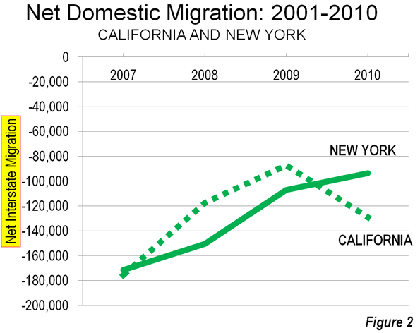
    In contrast, the Indian and Chinese spheres, for example, are united by deep-seated commonalities: food, language, historical legacy and national culture. A Taiwanese technologist who works in Chengdu while tapping his network across east Asia, America, and Europe does so largely as a Chinese; an Indian trader in Hong Kong does business with others of his “tribe” in Africa, Great Britain and the former Soviet Republics in east Asia. Beyond national borders, these spheres extend from their home countries to a host of global cities, such as Hong Kong, Singapore, London, New York, Dubai, San Francisco, and Los Angeles, where they have established significant colonies.

    The prospects for the last great global grouping, the Anglosphere, are far stronger than many expect. Born out of the British Empire, and then the late 20th Century, the Anglosphere may be losing its claim to global hegemony, but it remains the first among the world’s ethnic networks in terms of everything from language and global culture to technology. More than the Indian Sphere and Sinosphere, the Anglosphere has shown a remarkable ability to incorporate other cultures and people.

    In the future, we will see the rise of other networks, as well. An example would be the Vietnamese sphere of influence, which reflects both the rise of that particular Asian country, and the influence of its scattered diaspora across the world. Culture is key to understanding the Vietnamese sphere: the country’s history includes long periods of Chinese domination that made it resistant to being absorbed into the Sinosphere. Instead, as we argue, Vietnam is likely to be more closely allied, first and foremost, with the United States and its allies.

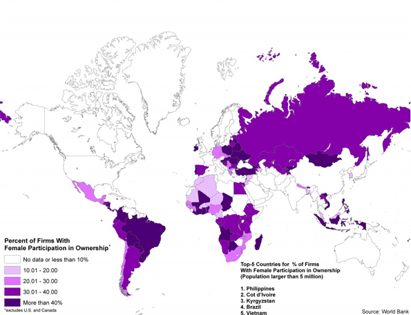
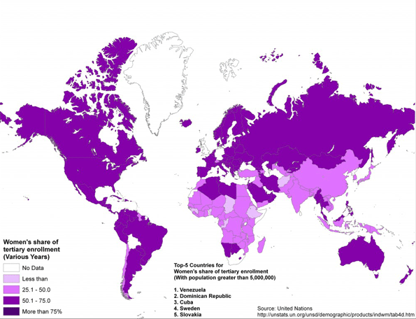
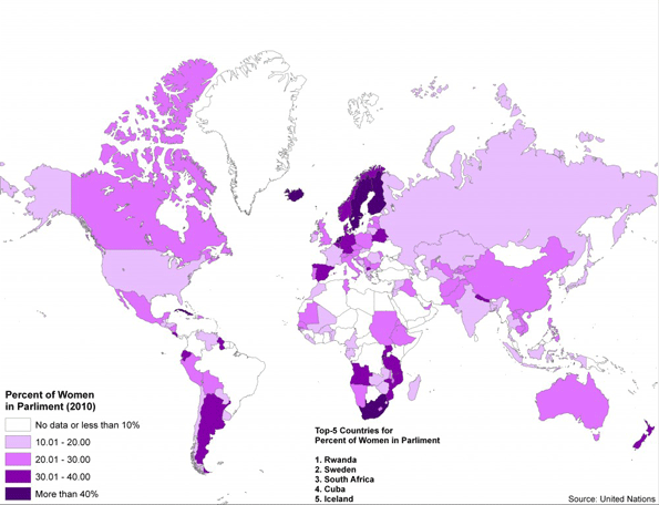
    Finally, our maps deal with basic demographic issues that will dominate the future. We trace the global rise of women to prominence in business, education and politics. Although Western nations still lead in female empowerment, we argue that the most significant changes are taking place in developing countries, notably in Latin America. It will be these women – in Sao Paolo, Mumbai, and Maseru – who increasingly will shape the future female influence on the world.

    Yet this positive development also contains the seed of dangers. Female empowerment, along with urbanization, has had a depressing effect on fertility rates, seen first in the highly developed countries, and now increasingly in developing ones. Looking out to 2030, many countries, including the United States and China, will be facing massive problems posed by too many seniors and not enough working age people.

    As has always been the case, the emerging world order will face its own crises in the future, with, no doubt, unexpected, unpredictable results. But our bet is solidly on the three spheres of influence which constitute the bulk of this report.

    For the full report, visit The New World Order website at the Legatum Institute.

    Report authors:

    Joel Kotkin is executive editor of NewGeography.com and is a distinguished presidential fellow in urban futures at Chapman University, and an adjunct fellow of the Legatum Institute in London. He is author of The City: A Global History. His newest book is The Next Hundred Million: America in 2050, released in February, 2010.

    Sim Hee Juat is currently a research associate with the Centre for Governance and Leadership at the Civil Service College of Singapore.

    Shashi Parulekar is an engineer by training. He holds a master’s in finance and an M.B.A. He has worked as a high-tech marketer in Asia for several decades.

    Jane Le Skaife is a doctoral candidate in the Department of Sociology at the University of California, Davis. She is currently conducting her dissertation research involving a cross-national comparison of Vietnamese refugees in France and the United States.

    Wendell Cox is a consultant specialising in demographics and urban issues, principal of Demographia and a visiting professor at the Conservatoire National des Arts et Metiers in Paris.

    Emma Chen is a senior strategist at the Centre for Strategic Futures, Singapore. The views expressed within this article are solely her own. Publication does not constitute an endorsement by the Centre for Strategic Futures, Singapore.

    Zina Klapper is Deputy Editor of www.newgeography.com. A Los Angeles-based writer/editor/consultant with a background in journalism, she works in multiple aspects of report presentation. The maps were prepared by Ali Modarres, Professor of Urban Geography at California State University, Los Angeles.

    We also owe a debt to our largely volunteer research staff, headed by Zina Klapper, Editor and Director of Research. This includes Gary Girod and Kirsten Moore from Chapman University, to whom we owe a special debt for directed study focused on the maps. We also wish to thank Sheela Bonghir from California State University at Northridge; Malcolm Yiong and Jasmin Lau at the Centre for Strategic Futures, Singapore, and Chor Pharn Lee at the Ministry of Trade and Industry and researcher Erika Ozuna, based in Dallas, Texas. Special thanks to Nathan Gamester at Legatum Institute in London for helping put this project together and seeing it to fruition.

  • Women Ascendent: Where Females Are Rising The Fastest

    You can find the future of the world’s women not in Scandinavia or the U.S., but among the entrepreneurs who line the streets of Mumbai, Manila and Sao Paulo. Selling everything from mangoes to home-made blouses, these women, usually considered the very bottom of their home country’s employment barrel, represent the cutting-edge of progress for women in the 21st century.

    This marks a departure from past decades, when the advancement of women was visible almost solely in the wealthiest of countries. Surveys of female achievements have consistently singled out just a sliver of the globe, but increasingly, women are making the greatest strides elsewhere — in the rapidly growing developing world.

    Women in these countries are newly empowered by remarkable gains in political representation, legal rights and, especially, education. But more important, they are rising in the 21st century’s key economic strata: as business owners.

    For our analysis of the countries where women are rising the fastest, we looked at three factors: education, politics and entrepreneurship. We studied the United Nations’ demographics on post-secondary education (current and historical) and on political participation. To assess the business environment, we examined statistics from Global Entrepreneurship Monitor on nascent entrepreneurship and the World Bank and World Economic Forum on gaps between male and female business ownership. We searched the global press, pored through research publications by financial institutions and NGOs, and visited some locations. Finally, we crunched the numbers, information and observations and came up with our own impressions.

    Our top picks for places where women were rising the fastest — as opposed to merely surfing an already advantageous position — were found largely in the developing world — particularly in Brazil, India, Vietnam and the Philippines.

    A vital benchmark of this progress is the large role that women play in business ownership in these places. In many developing countries the rate of female entrepreneurship surpasses that in the G-7 nations. Many become entrepreneurs by necessity: Often locked out of the of the best opportunities in the job market by cultural and sometimes legal barriers, women are starting businesses at rapid rates in Latin America, India, East Asia and even Africa and Central Europe.

    In contrast, female entrepreneurship rates aren’t rising in many of the most advanced countries. Despite talk of the feminization of advanced societies, the percentages of women-owned businesses are inching downward in the U.S., and they are stagnant in the E.U. To some extent, this slowdown reflects greatly expanded opportunities for a new generation of women, considerably more educated than their mothers, in both the mid-level job market and the highest corporate tiers. These changes have been accelerated by shifts in the nature of employment that favor “brains” and collaboration over traditional male advantages in “brawn” and single-minded ambition.

    The Rise of the Female Entrepreneur

    Latin America is a premiere example of the rise of female business ownership. Both Brazil and Costa Rica rank in the World Bank’s top 10 countries for female ownership participation. The region also stands out for its small gender gap in new businesses: Women are now starting businesses as often men, and sometimes succeeding. Among the top countries with the greatest equality between women and men in establishing new ventures, Global Entrepreneurship Monitor notes that many Latin American countries, especially Brazil and Peru, now have a gap that is smaller than in the U.S. or anywhere in Europe.

    The same trend is emerging in Asia. In the more tropical countries, where women are impeded by unpaid family work combined with a notoriously grim labor picture, many own marginal businesses. South Asia’s bright spot for female entrepreneurs is India, with its highly developed support structure of national-level and local organizations for women’s SMEs and early participation in micro-finance. And female entrepreneurs are thriving in Vietnam, the Philippines and Thailand as well. For example, 24% of Vietnam’s 100,000-plus incorporated enterprises are owned by women; 27% of its 3 million household businesses are also female-owned. The rate of female private business owners in China, at 11 out of 100, is also higher than the world average of 7%. Surprisingly, famously chauvinist Japan is the only country in the world where the percentage of women who own their own businesses, 13%, edges out the percentage of males who do.

    Eurasia and Central Eastern Europe have also experienced a surge in female entrepreneurial activity. As in Latin America, self-employment has often come about as a result of national tragedy and political dislocation — in this case, the economic disruption and male migration abroad that followed the fall of the Soviet Union.

    Data on women in African economies are sparse, with the positive news focused on Lesotho, ranked No. 1 and No. 2 by the World Economic forum for economic opportunity in the last two years, and, unsurprisingly, South Africa, the continent’s most developed nation, considered Africa’s best economic climate for women’s by The Economist Intelligence Unit. Ghana has also drawn attention, with a World Food Program-initiated salt start-up. Micro-financiers, development NGOs and the United Nations have assisted small-scale women entrepreneurs in African nations like Kenya in establishing micro industries such as processing soap, fruit and maize.

    Educated Women on the Front Lines

    Across the globe female gains in education have skyrocketed. In tertiary education — which includes post-high school vocational schools as well as colleges and universities — females now outnumber males in one-third of developing countries, including Brazil, Bangladesh, Honduras, Lesotho, Malaysia, Mongolia and South Africa. Worldwide, between 1970 and 2008, the number of female tertiary students expanded by 70 million, compared with 60 million for males.

    The Legal Right to Wages and Assets

    Along with economic and education gains, women in developing countries are making substantial political gains. Part of a broader movement throughout the developing world toward political empowerment, women are gaining increased access to capital and property ownership, and greater national attentiveness to issues specific to women, such as domestic violence and female health.

    One indication: The percentage of parliamentary seats held by women globally has risen considerably during the first decade of this century, and is now about 18%. As in entrepreneurship and education, the most dramatic gains now are not in the high-income countries but in the developing world, where sizable inroads to the very top tiers of government have also been made.

    Latin America has become the most visible emblem of rising female political power sweeping across a region. When Brazil elected Dilma Rousseff as president in 2010, it joined its neighbors Argentina, Costa Rica and, until recently, Chile in having a female head of state. Latin America, too, is a world leader for female political representation, with 30%-plus parliamentary representation in Costa Rica, Argentina, Ecuador and Bolivia.

    Yet some of the most astonishing changes in representation have taken place in Africa, where Rwanda now has the world’s highest percentage of women in parliament and cabinet seats. Each of Rwanda’s parliamentary houses comprises 50% or more women. South Africa, Angola, Mozambique, Uganda and Tanzania also boast above-average rates.

    The destiny of the global economy has shifted toward countries that once trailed behind but are now rapidly rising. In the same way, the trajectory of women’s progress — and the future of the ascendancy of women — has shifted from the developed to the developing world.

    This piece originally appeared at Forbes.com.

    Joel Kotkin is executive editor of NewGeography.com and is a distinguished presidential fellow in urban futures at Chapman University, and an adjunct fellow of the Legatum Institute in London. He is author of The City: A Global History. His newest book is The Next Hundred Million: America in 2050, released in February, 2010.

    Zina Klapper is a Los Angeles-based journalist, and Deputy Editor of newgeography.com.

    Photo by flickr user Dawn Danby

  • Domestic Migration: Returning to Normalcy?

    Even as the troubled economy has continued to hobble along, there may be hints that the domestic migration patterns from before the Great Financial Crisis could be returning at least in some states. This is evident in the recent national interstate migration data from the American Community Survey. This analysis reviews annual interstate migration data from the beginning of the Great Financial Crisis to 2010, with broad comparisons to earlier (2001-2006) data from the Census Bureau population estimates program (Note 1). The big stories are that Florida and Arizona show signs of recovery, the trend has reverted to more negative in California and the steady states are North Carolina (a big gainer of domestic migrants) and Illinois (a big loser of domestic migrants).

    Moreover, none of the states that have been perennial domestic migration losers moved into the top ten between 2007 and 2010, even as fast growing states such as Florida and Arizona were hard hit by the real estate bubble and saw migration rates decline. Notably, however, Pennsylvania, which had sustained modest domestic migration losses, rose to the number 8 position in 2010 (Table 1).

    Table
    Top Domestic Migration States: 2001-2010
      Year and Source
      2001-6 2007-9 2010
    Rank Census Estimates ACS ACS
    1 Florida Texas Texas
    2 Arizona North Carolina North Carolina
    3 Texas Arizona Florida
    4 North Carolina South Carolina Arizona
    5 Georgia Georgia Colorado
    6 Nevada Oklahoma South Carolina
    7 South Carolina Washington Virginia
    8 Tennessee Colorado Pennsylvania
    9 Virginia Virginia Washington
    10 Washington Utah Kentucky


    The Largest Gaining States:Some of the states with the largest gains seem to be returning toward their previous domestic migration volumes.

    Florida: For the last few years, the big news in interstate domestic migration has been in Florida. This state, which has grown by more than 5.5 times since 1950, had been the domestic migration leader for some years. However, as one of the four "ground zero" states (along with California, Arizona and Nevada) for its huge house price losses, Florida bottomed out at a loss of 38,000 domestic migrants, falling to 44th in 2007. The state lost another 16,000 interstate migrants in 2008. These were the first domestic migration loss since the 1940s for Florida.

    However, in 2009, Florida returned to growth, adding 21,000 domestic migrants. An even stronger recovery occurred in 2010, with a net 55,000 domestic migrants. This remains well below the peak of 265,000 recorded in Census estimate figures in 2004 and 2005. Nonetheless, Florida ranked third in domestic migration in 2010, trailing North Carolina by only 1000 as well as number one Texas. Part of Florida’s success is likely related to its housing affordability, which has been restored in all of the state’s major metropolitan areas with the exception of Miami. The recent repeal of Florida’s land rationing "smart growth" law should position the state for even more affordable housing and net domestic migration gains.

    Arizona: Arizona is another state that was hit hard by the housing bubble. Much has been written on Arizona’s recent hard times. Yet, unlike Florida, Arizona did not experience domestic migration losses in any year of the past decade. The state has routinely been among the top five in domestic migration, even during the darkest years of the Great Financial Crisis. Like the nation in general, Arizona reached its lowest net domestic migration figure in 2009 at 29,000, but recovered to 46,000 in 2010. Interstate domestic migration remains somewhat below the early 2000s figures, but is trending upwards.

    Texas: Texas took the interstate domestic migration crown away from Florida in 2006 at has been the nation’s leader since that time. According to Census estimates, Texas peaked in 2006 at 233,000 net domestic migrants. This was an artificially high peak, location by the outflow of people from Louisiana who were driven out by Hurricanes Katrina and Rita and the failure of responsible governments to properly maintain flood control infrastructure. From 2007 to 2009, Texas was also aided by its liberal land use policies that helped it avoid the real estate bubble, retaining lower house prices that made it more attractive to domestic migrants. Texas added more than 125,000 domestic migrants annually. However in 2010, net domestic migration dropped to 75,000. Nonetheless, even Texas indicates a return toward normalcy. In the first five years of the decade, Census data placed net domestic migration in Texas at only 40,000, well short of the 2010 figure.

    North Carolina: Through good times and bad, North Carolina was has been a consistent performer among the larger gainers. North Carolina ranked fourth in net domestic migration from 2001 through 2006, according to Census data. Then the state moved up to number two in every year from 2007 to 2010.   In 2010 domestic migration was 56,000, slightly below the 2001 to 2006 Census reported average of approximately 63,000. Like Texas, North Carolina largely escaped the real estate bubble, with house prices rising far less severely than on the West Coast, the Northeast, Florida, Nevada and Arizona, which could be a principal reason for its consistent domestic migration gains.

    The Largest Losing States:There were also indications that people continue to be among the most significant exports of California and New York, which wrestled for the bottom position for the entire decade. While The New York Times characterized the 2008 to 2010 domestic outmigration from California and New York as having slowed to a "relative trickle," the ACS data indicates that the spigot is still on.

    New York:New York experienced a net loss of 94,000 domestic migrants in 2010, a figure nearly equal to the population of its state capital, Albany. Despite this large loss, New York is doing better than earlier in the decade, when domestic outmigration averaged more than 200,000 from 2001 to 2006.

    California: California, however, may have taken a turn to the south. After having experienced the largest losses in the nation in 2007 (175,000), net domestic outmigration fell to 87,000 in 2009 and California relinquished the bottom position to New York. However, in 2010, California’s net domestic outmigration rose to 129,000 and the state recovered its former bottom ranking.

    Illinois: Illinois has been the most consistent performer among the largest losing states. According to Census data, domestic migration losses averaged 77,000 from 2001 to 2006. ACS data indicates similar losses, averaging 73,000 from 2007 to 2010.

    Normalcy Again? It is premature to suggest any long-term judgments on these early data. However, it would not be surprising to see the states with the highest costs of living (driven by high housing costs) and the least friendly business climates to lose domestic migrants to states with lower costs of living and more friendly business environments. For example, the fact that median house prices today in Phoenix are more affordable compared to the large metropolitan areas of coastal California than they were at the peak of the housing bubble may be part of what drove Arizona’s improved net domestic migration in 2010.

    —-

    Note 1: The Census Bureau provides annual estimates of domestic migration, however does not do so in census years, such as 2010, which is why this analysis uses American Community Survey data. For the purposes of data compatibility, 2007, 2008, 2009 and 2010 data from the American Community Survey (also conducted by the Census Bureau) is the principal source for recent trends. This analysis is different from the one by Kenneth M. Johnson of the University of New Hampshire Carey Institute, which detailed domestic migration results from the three year American Community Survey (2008-2010), and which was covered by The New York Times.

    Note 2: Leith van Onselen has recently described developments in the Phoenix housing market (in How Phoenix Boomed and Busted) during the last decade.

    Wendell Cox is a Visiting Professor, Conservatoire National des Arts et Metiers, Paris and the author of “War on the Dream: How Anti-Sprawl Policy Threatens the Quality of Life

    Photograph: Cape Coral, Florida (by author)

  • Back to the City?

    The 2010 Census results were mostly bleak for cities, especially for those who believed the inflated hype about the resurgence of the city at the expense of the suburbs.  Despite claims of an urban renaissance, the 2000s actually turned out to be worse than the 1990s for central cities.  The one bright spot was downtowns, which showed strong gains, albeit from a low base.  The resurgence of the city story seemed largely fueled by intra-census estimates by the government that proved to be wildly inflated when the actual 2010 count was performed.

    But beyond the headline numbers, there is intriguing evidence of a shift in intra-regional population dynamics in the migration numbers. The Internal Revenue Service uses tax return data to track movements of people around the country on a county-to-county and state-to-state basis. These can be used to look at movements of people within a metro area.

    Because this data is at the county level, it does not map directly to what we might think of as the “urban core” as most counties that are home to central cities contain large suburban areas as well. There are also areas inside many central cities themselves that are suburban in their built form.

    However, there are a limited number of cities that have combined city-county definitions that approximate the urban core. Looking at a few of these – New York, Philadelphia, San Francisco, and Washington, DC – we see that over the 2000s out-migration from the core to the suburban counties was relatively flat or even declined late in the decade as general mobility declined in the Great Recession. In contrast, migration from the suburban counties to the core stayed flat or actually increased, even late in the decade when again overall migration declined nationally.

    It should be stressed that the overall trend is still that of net out-migration from the core to the suburbs. But in searching for any potential inflection point, changes in the dynamics are clearly of interest.

    New York City

    First let us look at New York City. The city proper consists of five boroughs, each of which is a separate county. Treating the city as a whole as the core reveals these migration trends during the 2000s:


    Note: Core defined as the five boroughs of New York City

    This chart renders migration as an index, to show changes in in- and out-migration on the same scale. This should not be confused with the total number of people moving, which still shows overall net out-migration, though the trend lines show the same dynamic as above:


    Note: Core defined as the five boroughs of New York City

    Philadelphia

    Perhaps the most dramatic shift in these four cities was in Philadelphia, where the central city actually gained population for the first time since 1950.

    Here are the raw migration numbers, which again show net out-migration, but a distinct shift over the decade.

    San Francisco

    The Bay Area has been divided into two metro areas by the government, San Francisco and San Jose. Therefore, an intra-regional migration analysis looking at San Francisco alone will miss certain migration within the broader Bay Area. With that caveat in mind, we see again the same trend, albeit somewhat less pronounced:

    And here are the total migrants:

    Washington, DC

    Due to its very nature as a government town, Washington’s migration patterns differ from the many other cities. However, it has still experienced the same suburbanization phenomenon as the rest of America, and the same changes in intra-regional migration dynamics as the other cities highlighted here, though we see the shift beginning only in mid-decade:

    And the raw values:

    Conclusion

    Given the overblown triumphalist rhetoric about the urban core that ultimately hasn’t been backed up by the data, we should be cautious about reading too much into this. Again, net migration remains outward towards the suburbs and away from denser cities to smaller, generally less dense ones (from Chicago to Indianapolis or New York to Raleigh). Overall city population figures were disappointing. And the housing crash and the Great Recession have clearly wreaked havoc with migration patterns on a national level.

    Still, these are clearly figures that should inspire some at least small-scale optimism in urban advocates.  There has clearly been a shift affecting the net migration in these cities. And the same pattern is visible, though less easily attributable to just the urban core, in a large number of other metros around the country.  In particular, the fact the in-migration from the suburbs to the core held steady or even increased is a sign of some urban health.

    Back to the city as a mass movement?  Not yet.  But it’s certainly an improvement. These intra-regional migration statistics are key figures to keep an eye on as we look for any sign of a true inflection point in the overall population trends for America’s urban centers. The whole pattern could also shift again — in one direction or the other — as the economy, albeit slowly, comes back to life and people once again get back into the housing market.

    Aaron M. Renn is an independent writer on urban affairs based in the Midwest. His writings appear at The Urbanophile, where this piece originally appeared. Telestrian was used to analyze data and to create charts for this piece.

    Chicago photo by Storm Crypt / Flickr

  • Brand Loyalty Dominates Trip to Work

    Many public sector mavens watch like the Dow Jones average the shares of workers using various modes of transportation on work trips to see how their favorite mode is doing.  One shouldn’t be surprised when a certain hyperbole creeps into the interpretation of the trends.   But in reality not a whole lot is changing, despite many assertions of ballooning growth from some sectors. 

     We should start in 1960 with the first census to cover the Journey to Work.  Back then about two-thirds of workers used a car or truck. More interestingly 13% were on transit, 10% walked and 7% worked at home (think farmers).   As Figure 1 indicates, effectively all of the growth in the last 50 years has occurred in the private vehicle mode.  The melding here of walking and working at home misleads a bit because walking has continually declined while, due to the internet, working at home – once the farm decline reached bottom – has been the “mode” with the greatest and most consistent share of growth in the period.


    Source: 1960-2000 decennial Census; 2010 ACS

    Meanwhile the transit and walk modes have declined in share since the last half century but seem more recently to have bottomed out and reached some base level. 1

    Table 1 shows the relatively stable pattern for the last 20 years in broad terms. 

    1990 decennial

    2000 decennial

    2010

    ACS

    WORKERS

    100%

    100%

    100%

    DRIVE ALONE

    73%

    76%

    77%

    CARPOOL

    13%

    11%

    10%

    TRANSIT

    5%

    5%

    5%

    TAXI 

    0%

    0%

    0%

    BICYCLE

    0%

    0%

    0%

    WALKED

    4%

    3%

    3%

    OTHER

    1%

    1%

    1%

    WORKED AT HOME

    3%

    3%

    4%


    For Figure 1 and Table 1, the 2000 and earlier data are from the decennial censuses. The 2010 data are from a new source, the American Community Survey, which seeks to replicate the census structure.   These data are therefore not strictly comparable.  It has been observed that the ACS has tended to understate carpooling and overstate transit despite best efforts to assure comparability.

    Given the breadth of coverage of the census, it has immense value but a better handle on the mode share question can be found in the National Household Travel Survey (NHTS) of the Federal Highway Administration.  It replicates the census question asking about the usual mode of commuting, but it asks it as part of a collection of a complete diary of a day’s travel for each member of the household. It gets the what did you do yesterday response as well for the same person.   That means we can compare the person’s responses to the two separate queries and learn a great deal about the relationships between the responses. 

    This comparison between census and NHTS products helps state and metro planners know how their surveys might map to the census and helps test the utility of the census products. Just as importantly, it provides a comparison between what people say they do and what they actually do and it tells more about what alternatives travelers shift to when they don’t do “the usual”.   

    When the NHTS asks the question in the “actually-did-yesterday” format things change, in some cases appreciably.

    ‘Usual’

    On  Travel  Day Commuted   by:

    Commute

     Mode:

    Drove Alone

    Carpool

    Transit

    Walk

    Bike

    Other

    Drove Alone

    93.5

    5.6

    0.1

    0.5

    0.1

    0.4

    Carpool

    42.9

    54.8

    0.5

    1

    0

    0.8

    Transit

    13.2

    9.2

    68.3

    6.6

    0.8

    1.9

    Walk

    6.1

    9.3

    3.4

    80.2

    0.2

    0.7

    Bike

    13.8

    3.3

    6

    2.6

    73

    1.4

    Other

    64.1

    19

    4.2

    4.3

    0.3

    8

    Source: NHTS 2009

    Quick Findings

    If we study the yellow boxes we see the “loyalty” relationship between what people say they do and what they actually do.   There are some interesting stories here.

    Drove alone:  According to the NHTS, 93.5% of the people who said they usually drive alone to work actually did.  When they didn’t they almost exclusively shifted to carpooling, with only about 1% shifting out of the auto mode.  This is basically identical to the responses in the 2001 NHTS.2

    Transit:  Only about 68.3% of usual transit users actually used it on a specific day.  The big shift is to the auto-based modes, solo driving or pooling, accounting for more than three quarters of the shift, with the remainder largely shifting to walking.  This is almost the identical loyalty share observed in 2001, but with greater shifts to the auto instead of walking.

    Walking:  Surprisingly about 80% of those who say they usually walk actually do.  Again, when these commuters don’t walk, about three/quarters of the shift is to the private vehicle, with the remainder largely shifting to transit. Also very similar in loyalty to 2001 measures, but showing some increase in transit shifts.  

    Bicycle:   biking exhibits a little less “loyalty” than walking and a little more than transit.   Biking showed a decrease in loyalty from the 77% observed in 2001, perhaps reflecting that the increases in biking we have seen among less inveterate bikers.  The shift to the auto-based modes is less pronounced than the other cases with about a 63% share of the shift.  Transit and walking each obtain appreciable shares of the remainder.   Use of the auto modes as an alternative increased substantially from 2001. 

    Carpooling:  Carpooling is the great surprise.  While transit exhibited the lowest level of loyalty of all modes in 2001 it was surpassed by carpooling in 2009.  Carpooling showed a dramatic decrease in loyalty from 75% in 2001 to 55%, in 2009.  The dominant shift is to driving alone with only about 2% shifting to non-auto modes.  So the auto-based share remains about the same as in 2001. 

    What to Make of All This

    In today’s world we have seen substantial increases in variability in trips to work  – variability  in time of departure, arrival, choice of route to work, even a choice as to whether or not one travels to work at all  with telecommuting becoming more significant every day.  We should not be surprised that there is variability in choice of mode of travel.  Some part of this may simply be that some workers see transit, biking, or walking as the socially preferred modes and will state so when asked – kind of the “good citizen” response – they know what they are supposed to want – “but yesterday was different!”    

    Clearly, auto users tend to remain auto users, with a 98-99% loyalty whether in a carpool or driving solo.  Shifting either way often means things like: the car is in the shop, my wife needs the car, or carpool buddy is on leave, lost a job, or busy doing something else.  This does tell us that carpooling is becoming less formal and more of an occasional and more flexible activity, abetted by cell phones and apps.  One could speculate that these workers often do not have a serious option to the auto.   

    Transit users’ swing is substantial, with significant implications.  Actual users come in at 3.7% of travel rather than the 5% shown for the “usually use” response.  About 3.5% are the usual transit riders who are actually using transit. In terms of survey response reliability we are dancing on the thin edge of trustworthy responses in terms of observation density.    But even with that caveat it would seem appropriate for transit providers to recognize that a significant portion of their riders are “in for the day” because their usual circumstance changed.  Also worth noting is that given that auto users are about 20 times the number of transit riders, an insignificant shift from auto to transit – unnoticeable on the roads – could swamp transit use.   If all the car users had their car in the repair shop once a month it could double transit use in most regions.

    Walkers and bikers, who are those most likely to be affected by weather, both do better than transit in terms of brand loyalty.  This may all be a product of trip length. It has been observed in the past that walkers have an average trip length that is typically so short (circa 15 minutes or about a mile)  that transit (given typical wait times of close to 15 minutes) is not a realistic option so on bad weather days the car may be the substitute. Bike trip lengths to work may be significantly longer than walking so that transit can become a viable option, depending on wait times and routing.    

    Alan E. Pisarski is the author of the long running Commuting in America series. A consultant in travel behavior issues and public policy, he frequently testifies before the Houses of the Congress and advises States on their investment and policy requirements.

    Photo by Nathan Harper, Bottleleaf

    —————–

    Wendell Cox covered this topic in greater detail in a recent New Geography posting Oct 17 2011

    Commuting in America III pg 63

  • Political Footballs: L.A.’s Misguided Plans For A Downtown Stadium

    Over the past decade Los Angeles has steadily declined. It currently has one of the the highest unemployment rates (roughly 12.5%) in the U.S, and there’s little sign of a sustained recovery. The city and county have become a kind of purgatory for all but the most politically connected businesses, while job creation and population growth lag not only the vibrant Texas cities but even aged competitors such as New York.

    Rather than address general business conditions, which sorely need fixing, L.A. Mayor Mayor Antonio Villaraigosa and the other ruling elites have instead focused on revitalizing the city’s urban core, which has done little to boost the region’s overall economy in generations. The most recent example of such foolishness is a $1.5 billion plan to build a football stadium, named Farmers Field, downtown,unanimously approved by the city’s City Council and backed by the city’s “progressive” state delegation.

    Like most of  the dominant political class, California Senator and former City Council member  Alex Padilla cites the sad state of the local economy as justification for approving the plan. But, in reality, it’s hard to find something more profoundly irrelevant than a football stadium.

    Indeed years of independent investigations have discovered that urban vanity projects like sports teams and convention centers add little to permanent employment or overall regional economic well-being. As a Minneapolis Fed study revealed, consumers simply shift their expenditures from other activities to the new stadium. Certainly mega-stadiums have done little to boost sad-sack, depopulating cities such as St. Louis, Baltimore or Cleveland.

    Commitments to mega-projects tend to further drive urban areas into debt, largely by issuing more bonds that taxpayers are obligated to pay back. One particularly gruesome case can be found in Harrisburg, Pa., whose underwriting of a minor league baseball team helped push the city into bankruptcy. To get the stadium deal, Los Angeles, already over-indebted and suffering a poor credit rating, will issue another $275 million.

    Such projects often obscure the real and more complex challenge of nurturing broad-based economic growth. This would require substantive change in a city or regional political culture. Instead the football stadium services two basic political constituencies: large unions and big-time speculators, particularly in the downtown area. The fact that the stadium will be built with union labor, for example, all but guaranteed its approval by the city’s trade union-dominated council.

    Downtown developers and “rent-seeking” speculators, the other group behind the project, have siphoned hundreds of millions in tax breaks and public infrastructure in the past decade. They have done so – subsidizing companies from other parts of Los Angeles, entertainment venues and hotels — in the name of a long-held, impossible dream of turning downtown Los Angeles into a mini-Manhattan. Perhaps no company has pushed this more effectively than the stadium developer Anschutz Entertainment Group, a mass developer of generic entertainment districts around the world. AEG has expanded its influence by doling out substantial financial donations to Mayor Villaraigosa and others in the city’s economically clueless political class.

    This explains how the stadium was exempted from the state’s draconian anti-greenhouse gas legislation. The city promises that the stadium will be the “most transit-friendly” football stadium in the nation, which strikes locals as absurd. Football crowds tend to be drawn largely from  affluent types who don’t live anywhere close to downtown and rarely take public transit to their jobs, much less over the weekend. D.J. Waldie, a leading Los Angeles writer, described the entire project as “cloaked in green snake oil.

    An even more nebulous claim is that downtown needs the investment in order to drive regional growth. To be sure, recent years have seen the growth of a central city restaurant scene, and some 30,000 residents now live in the area compared to closer than 20,000 a decade ago. Yet just outside the immediate, highly-subsidized core, population growth in the surrounding parts of central city over the past decade stood at a mere 0.7%, the lowest rate since the 1950s. The vast majority of the region’s population growth took place in the far-flung regions of the San Fernando Valley.

    As an economic engine, downtown LA simply does not warrant the attention, nor the special treatment,  that the city’s ruling elites give it. For one thing, it represents a far smaller part of the city’s economy when you compare it to the urban cores of Washington, D.C., or New York City. Indeed, in New York and D.C. roughly 20% of all employment is in the central core; in Los Angeles it’s barely 2.5%.

    And, despite all the hype, fewer people now work in downtown L.A than in the 1980s and 1990s, when the area was populated by corporations and small businesses, many in manufacturing and trade, instead of hip hangouts. A more recent analysis shows that, despite all the hype, the downtown area has created virtually no new net jobs over the past decade.

    LA’s leaders should therefore focus on the systematic causes for the region’s ailing economy. One source of the problem lies in tough environmental rules that, although lifted on behalf of football, clamp on growth of virtually every other industry, including the city’s port and manufacturing sector. Powerful green interests, for example, make any plan to modernize the port all but impossible. This could prove catastrophic when the widening of the Panama Canal will allow aggressive, cheaper posts in the Gulf or Southeast U.S. to compete with the Pacific Asian trade that has driven LA’s port economy for decades.

    Los Angeles’ huge industrial sector has also been a victim of the regulatory tsunami. Manufacturers have lost roughly one-third of their jobs over the past decade as firms head out to more congenial regions with less onerous regulatory burdens. Sadly, Los Angeles has benefited little from the recent upsurge in manufacturing nationwide when compared with metropolitan areas such as Detroit, Salt Lake City and San Antonio.

    Even Hollywood, an industry less affected by green regulations, has begun to lose steam. Film production has dropped by more than half over the past 15 years. LA’s share of film and television production has eroded as well, with much  of the new work headed to Toronto, New Mexico, New Orleans, New York and Atlanta. All these cities offer richer incentives to attract productions than the world’s self-proclaimed “entertainment capital.”

    Faced with these serious regional challenges, officials should place less emphasis on football and creating another generic downtown and more on the city’s uniquely vibrant and heavily immigrant-driven small-business sector, which has been stifled by the state’s regulatory excess as well as the city’s legendary bureaucracy. Business consultant Larry Kosmont notes that the system is particularly tough on smaller, less politically connected firms. “It usually takes two to three times more to process anything in L.A., compared even to surrounding cities,” Kosmont told the Wall Street Journal. “It makes a big difference if you are a major Korean airline or AEG or if you are an independent entrepreneur.”

    Yet to date these entrepreneurs  receive little respect from City Hall. They  are unlikely to be granted the sort of papal dispensations from green legislation so readily given to the football stadium and other downtown projects. Until the disconnect of the leaders from the city’s real economic essence ends, Los Angeles, a city uniquely blessed by its population, climate and location, will continue to flounder, a perpetual underperformer among America’s great urban areas.

    This piece originally appeared at Forbes.com.

    Joel Kotkin is executive editor of NewGeography.com and is a distinguished presidential fellow in urban futures at Chapman University, and an adjunct fellow of the Legatum Institute in London. He is author of The City: A Global History. His newest book is The Next Hundred Million: America in 2050, released in February, 2010.

    Photo "LA Night Lights" by flickr user Steve Jurvetson

  • More Americans Move to Detached Houses

    In defiance of the conventional wisdom in the national media and among most planning professionals, Americans continue not only to prefer, but to move into single family detached houses. Data from the 2010 American Community Survey indicates that such housing attracted 79.2% of the new households in the 51 major metropolitan areas (over 1,000,000 population) over the past decade.

    In contrast households in multi-unit buildings (apartments and condominiums) represented 11.8% of the new housing, while two-unit attached housing represented 11.3% of the increase. There was a 2.3% decline in the "other" category of new housing, which includes mobile homes and boats. A total of 4 million net new occupied detached houses were added in the largest metropolitan areas, while there were 590,000 additional apartments and condominiums and 570,000 attached houses (Figure 1).

    Detached Vacancy Rate Rises Less than Multi-Unit: Another conventional assumption is that single family homes have been disproportionately abandoned by their occupants, particularly since the collapse of the housing bubble. This is also not true. In 2010 detached housing enjoyed a 92.4% occupancy rate in 2010 which is higher than the 89.4% occupancy rate in attached housing and 84.2% occupancy rate in multi-unit buildings. Because a more of the multi-unit housing is rental, it is to be expected that the vacancies would be the highest in this category. However, at the national level, overall vacancy rates rose the most in multi-unit housing, with an increase of 61%, from 10.7% in 2000 to 17.1% in 2010. The vacancy rate in detached housing rose at a slower rate, from 7.3% in 2000 to 10.7% in 2010, an increase of 48%. Attached housing – such as townshouses – have the slowest rise in vacancy rate, from 8.4% in 2000 to 11.0% in 2010, an increase of 32% (Figure 2).

    Detached and Attached Up in Most Markets, Apartments and Condominiums Down in Most: The move to detached housing was pervasive at the major metropolitan area level. Among the 51 largest metropolitan areas, the share of detached housing rose in 44 and declined in seven. The share of attached housing rose in 32 of the metropolitan areas, while declining in 19. Multi-unit housing experienced an increase in its market share in only three markets, while declining in 48.

    Largest Metropolitan Areas: Detached housing also increased more than attached housing and multi-unit housing in each of the nation’s five largest metropolitan areas.

    • In the largest metropolitan area, New York, 51.9% of the new housing was detached. This is considerably more than the 36.9% detached market share in 2000. Multi-unit housing accounted for 24.1% of the increase in the market. This is a far smaller share than the 55.7% that multi-unit housing represented in 2000. Attached housing was 19.9% of the increase, nearly 3 times its 2000 share of 6.7%. This movement of New Yorkers to less dense housing forms is particularly significant, in view of the fact that New York has historically had the lowest share of lower density housing (detached and attached) and the highest share of multi-unit houses.
    • In the second largest metropolitan area, Los Angeles, 96.0% of the new housing was detached. This is nearly double the 49.7% that detached housing represented of the market in 2000. The balance of the new housing was split between a share of 18.6% for multi-unit housing and a loss of 11.8% in the attached housing. The share of new units represented by multi-unit houses was less one-half than its percentage of the market in 2000 (39.0%).
    • In the third largest metropolitan area, Chicago, 95.9% of the new housing was detached, well above the 52.5% share in 2000. There was a huge loss in apartment and condominium share, at 31% of the market, while attached housing captured 40.4% of the market.
    • In the fourth largest metropolitan area, Dallas Fort Worth, 84.3% of the new housing was detached, well above the 62.0% share in 2000. Multi-unit housing accounted for 13.5% of the increase, approximately one-half the 2000 market share. Attached housing represented 3.2% of the increase.
    • In the fifth largest metropolitan area, Philadelphia, 77.6% of new housing was detached, well above the 45.3% market share for detached housing in 2000. Apartments and condominiums accounted for 27.7% of the increase between 2000 and 2010, slightly more than the 2000 market share 23.7%. Attached housing represented a minus 4.3% of the new housing.

    Despite being only the fourth largest metropolitan area, Dallas-Fort Worth accounted for 46% of the new housing in the five largest metropolitan areas (Figure 3).

    The three largest metropolitan markets where there was an increase in multi-unit housing share were San Jose, New Orleans and Denver. In San Jose, 55.5% of new housing was multi-unit, while only 10.3 percent was detached. New Orleans had a similar 10.5% detached new housing share, while 65.8% of the new housing was multi unit. In Denver, 31.3% of the new housing was multi-unit, while 60.2% was detached.

    The share of detached housing also declined between 2000 and 2010 in Boston, Kansas City, Minneapolis-St. Paul and Portland. In each of these metropolitan areas, the share of attached housing increased, while the share of multi-unit housing decreased. Nonetheless, detached housing continued to attract a majority of new housing in Kansas City (70.8 percent) and Portland (56.6 percent). Despite Portland’s strong planning emphasis on high density housing, its share of multi-unit housing, and 26.8% between 2000 and 2010 was less than its 2000 market share of 27.5%, with a strong 20.6 percent share in attached housing. Attached housing also accounted for a comparatively large share of new housing in Boston (45.7 percent), Minneapolis-St. Paul (39.7 percent) and Kansas City (25.8 percent). The stronger densification policies that existed in Minneapolis-St. Paul until the middle of the decade may have artificially raised the share of attached new housing.

    Share by housing type data is provided for the major metropolitan areas in Tables 1 and 2.

    Table 1
    Occupied Housing by Major Metropolitan Area: 2000
    Metropolitan Area Detached Attached Multi-Unit Other
    Atlanta, GA 66.6% 3.5% 25.5% 4.4%
    Austin, TX 57.7% 3.7% 32.1% 6.6%
    Baltimore, MD 46.0% 28.5% 24.2% 1.3%
    Birmingham, AL 68.3% 2.6% 17.9% 11.2%
    Boston, MA-NH 48.9% 4.4% 45.4% 1.3%
    Buffalo, NY 60.0% 2.8% 35.1% 2.1%
    Charlotte, NC-SC 67.5% 3.4% 21.8% 7.3%
    Chicago, IL-IN-WI 52.5% 6.3% 40.1% 1.1%
    Cincinnati, OH-KY-IN 64.7% 3.6% 27.8% 3.9%
    Cleveland, OH 65.7% 5.5% 27.7% 1.2%
    Columbus, OH 62.8% 5.5% 29.1% 2.6%
    Dallas-Fort Worth, TX 62.0% 3.1% 30.3% 4.6%
    Denver, CO 60.9% 7.8% 29.0% 2.3%
    Detroit,  MI 70.5% 5.5% 20.7% 3.3%
    Hartford, CT 60.0% 5.2% 34.1% 0.8%
    Houston, TX 61.4% 3.6% 29.1% 6.0%
    Indianapolis. IN 68.4% 5.2% 23.2% 3.3%
    Jacksonville, FL 63.5% 3.9% 22.3% 10.3%
    Kansas City, MO-KS 71.3% 4.6% 21.4% 2.6%
    Las Vegas, NV 53.4% 6.0% 34.7% 5.9%
    Los Angeles, CA 49.7% 8.6% 39.6% 2.0%
    Louisville, KY-IN 70.7% 2.1% 22.2% 5.0%
    Memphis, TN-MS-AR 69.1% 3.8% 22.8% 4.2%
    Miami, FL 45.4% 9.9% 42.1% 2.6%
    Milwaukee,WI 55.7% 5.3% 38.3% 0.7%
    Minneapolis-St. Paul, MN-WI 62.8% 7.7% 27.4% 2.0%
    Nashville, TN 64.9% 4.4% 24.4% 6.2%
    New Orleans. LA 59.9% 7.7% 28.5% 3.9%
    New York, NY-NJ-PA 36.9% 6.5% 56.3% 0.4%
    Oklahoma City, OK 71.6% 3.1% 19.2% 6.0%
    Orlando, FL 61.5% 4.5% 25.1% 8.9%
    Philadelphia, PA-NJ-DE-MD 45.3% 29.8% 23.5% 1.4%
    Phoenix, AZ 61.6% 6.1% 24.9% 7.4%
    Pittsburgh, PA 68.8% 6.5% 20.4% 4.4%
    Portland, OR-WA 63.8% 3.3% 27.5% 5.5%
    Providence, RI-MA 54.3% 2.9% 41.6% 1.2%
    Raleigh, NC 63.6% 5.2% 21.5% 9.8%
    Richmond, VA 71.3% 4.9% 20.4% 3.4%
    Riverside-San Bernardino, CA 67.0% 5.1% 18.6% 9.3%
    Rochester, NY 65.7% 4.3% 26.5% 3.5%
    Sacramento, CA 66.1% 6.0% 24.0% 3.9%
    Salt Lake City, UT 67.0% 4.8% 25.4% 2.8%
    San Antonio, TX 67.4% 2.9% 22.2% 7.5%
    San Diego, CA 51.7% 9.4% 34.5% 4.4%
    San Francisco-Oakland, CA 50.3% 9.3% 39.1% 1.3%
    San Jose, CA 57.0% 9.1% 30.5% 3.4%
    Seattle, WA 60.2% 3.5% 31.6% 4.8%
    St. Louis,, MO-IL 70.2% 3.1% 21.9% 4.8%
    Tampa-St. Petersburg, FL 58.4% 4.6% 25.7% 11.4%
    Virginia Beach-Norfolk, VA-NC 61.4% 10.4% 25.2% 3.0%
    Washington, DC-VA-MD-WV 47.6% 19.4% 32.1% 0.8%
    Average (Weighted) 55.9% 7.5% 33.3% 3.3%
    Data from 2000 Census
    Metropolitan areas over 1,000,000 population as defined in 2010


    Table 2
    Occupied Housing by Major Metropolitan Area: 2010
    Metropolitan Area Detached Attached Multi-Unit Other
    Atlanta, GA 69.2% 5.3% 22.7% 2.7%
    Austin, TX 60.4% 2.6% 31.8% 5.1%
    Baltimore, MD 47.4% 27.3% 24.2% 1.1%
    Birmingham, AL 70.8% 2.4% 16.8% 10.0%
    Boston, MA-NH 48.7% 5.9% 44.2% 1.2%
    Buffalo, NY 62.3% 2.9% 33.0% 1.8%
    Charlotte, NC-SC 68.9% 5.1% 20.4% 5.6%
    Chicago, IL-IN-WI 54.2% 7.6% 37.1% 1.1%
    Cincinnati, OH-KY-IN 68.9% 4.8% 23.2% 3.1%
    Cleveland, OH 68.7% 5.1% 25.1% 1.1%
    Columbus, OH 64.1% 7.3% 26.6% 2.1%
    Dallas-Fort Worth, TX 65.9% 3.1% 27.4% 3.6%
    Denver, CO 60.8% 7.9% 29.4% 1.9%
    Detroit,  MI 71.6% 6.3% 19.1% 2.9%
    Hartford, CT 60.9% 5.3% 33.1% 0.7%
    Houston, TX 65.1% 3.5% 26.0% 5.3%
    Indianapolis. IN 71.3% 5.0% 21.1% 2.6%
    Jacksonville, FL 66.3% 4.8% 21.3% 7.6%
    Kansas City, MO-KS 71.3% 6.4% 20.1% 2.2%
    Las Vegas, NV 60.9% 5.4% 29.9% 3.8%
    Los Angeles, CA 51.0% 8.0% 39.0% 1.9%
    Louisville, KY-IN 71.6% 3.6% 20.9% 4.0%
    Memphis, TN-MS-AR 72.5% 3.3% 20.4% 3.7%
    Miami, FL 47.0% 10.8% 40.0% 2.1%
    Milwaukee,WI 56.2% 6.5% 36.5% 0.8%
    Minneapolis-St. Paul, MN-WI 61.5% 11.0% 25.9% 1.6%
    Nashville, TN 67.2% 5.6% 22.3% 4.9%
    New Orleans. LA 65.1% 6.1% 24.6% 4.2%
    New York, NY-NJ-PA 37.2% 6.7% 55.7% 0.4%
    Oklahoma City, OK 74.3% 3.0% 17.1% 5.6%
    Orlando, FL 64.1% 5.5% 23.4% 6.9%
    Philadelphia, PA-NJ-DE-MD 46.6% 28.5% 23.7% 1.3%
    Phoenix, AZ 67.2% 4.8% 22.2% 5.8%
    Pittsburgh, PA 69.4% 7.5% 19.1% 4.0%
    Portland, OR-WA 62.8% 5.5% 27.4% 4.3%
    Providence, RI-MA 55.7% 3.7% 39.6% 1.0%
    Raleigh, NC 65.4% 8.0% 20.5% 6.2%
    Richmond, VA 73.2% 4.9% 19.0% 3.0%
    Riverside-San Bernardino, CA 70.7% 4.3% 17.1% 7.9%
    Rochester, NY 66.9% 4.8% 25.3% 2.9%
    Sacramento, CA 68.8% 5.6% 22.6% 3.0%
    Salt Lake City, UT 67.8% 6.1% 23.9% 2.2%
    San Antonio, TX 70.8% 2.2% 21.1% 5.9%
    San Diego, CA 53.0% 9.0% 34.5% 3.5%
    San Francisco-Oakland, CA 50.7% 9.4% 38.8% 1.1%
    San Jose, CA 54.3% 10.7% 32.0% 3.0%
    Seattle, WA 60.5% 4.2% 31.5% 3.8%
    St. Louis,, MO-IL 70.8% 4.2% 21.1% 3.9%
    Tampa-St. Petersburg, FL 59.6% 5.6% 24.7% 10.1%
    Virginia Beach-Norfolk, VA-NC 62.5% 11.1% 24.0% 2.5%
    Washington, DC-VA-MD-WV 48.1% 19.6% 31.7% 0.7%
    Average (Weighted) 57.8% 7.9% 31.5% 2.8%
    Data from 2010 American Community Survey
    Metropolitan areas over 1,000,000 population as defined in 2010


    In Housing, Preference Trumps Policy: The trend of the last decade is evidence of a continued preference of American households for detached housing. The results are remarkable for at least two reasons:

    • The first is that there have been unprecedented policy initiatives to discourage, if not to prohibit the building of new detached houses. It seems likely that the miniscule new detached housing share in San Jose, for example, is a direct result of that metropolitan area’s virtual prohibition of new detached housing, rather than any evidence that households have begun to prefer higher density housing. A small detached housing share in the face of a strong public policy bias toward higher density housing says nothing about preferences.
    • Second; the media and wishful advocates of denser settlement patterns have continuously referred to detached housing as having been severely overbuilt during the housing bubble, while suggesting an imperative for households to move into multiunit, often rented housing. The new data, with the larger increase in multi-unit vacancy rates, indicates that there was at least as much overbuilding in more dense housing types as there was in detached housing.

    Despite the expressed preferences of planners, academics and even many builders, American households continue to make their own decisions about housing.

    Wendell Cox is a Visiting Professor, Conservatoire National des Arts et Metiers, Paris and the author of “War on the Dream: How Anti-Sprawl Policy Threatens the Quality of Life

    Lead photo: Houses in Los Angeles. Photograph by author.

  • Overpopulation Isn’t The Problem: It’s Too Few Babies

    The world’s population recently passed the 7 billion mark, and, of course, the news was greeted with hysteria and consternation in the media. “It’s not hard to be alarmed,” intoned National Geographic. “We should all be afraid, very afraid,” warned the Guardian.

    To be sure, continued population increases, particularly in very poor countries, do threaten the world economy and environment — not to mention these countries’ own people. But overall the biggest demographic problem stems not from too many people but from too few babies.

    This is no longer just a phenomenon in advanced countries. The global “birth dearth” has spread to developing nations as well. Nearly one-third of the 59 countries with “sub-replacement” fertility rates — those under 2.1 per woman — come from the ranks of developing countries. Several large and important emerging countries, including Iran, Brazil and China, have birthrates lower than the U.S.

    In the short run this is good news. It gives these countries an opportunity to leverage their large, youthful workforce and declining percentage of children to drive economic growth. But over the next two or three decades — by 2030 in China’s case  – these economies will be forced to care for growing numbers of elderly and shrinking workforces. For the next generation of Chinese leaders, Deng Xiaoping’s rightful concern about overpopulation at the end of the Mao era will shift into a future of eldercare costs, shrinking domestic markets and labor shortages.

    This scenario is already a reality in Japan and much of the European continent, including Greece, Spain, Portugal, much of Eastern Europe, Scandinavia and Germany. Adults over the age of 65 make up more than 20% of these countries’ populations — compared with 15% in the U.S. —  and their numbers could double by 2030, according to researchers Emma Chen and Wendell Cox.

    In many of these countries, rising debt burdens and shrinking labor markets have already slowed economic growth and suppressed any hope for a major long-term turnaround. The same will happen to even the best-run European economies, just as  it has in Japan, whose decades-long growth spurt ended as its workforce began to shrink.

    By 2030 the weight of an aging population will strangle what’s left of these economies. Germany, Japan, Italy and Portugal, for example, will all have only two workers for every retiree. The U.S. will fare somewhat better, with closer to three workers per retiree. By 2030 the median age  will also be higher in China and Korea than in the U.S. This  age difference will grow substantially by 2050, according to the Stanford Center on Longevity.

    The biggest impact of aging, however, will not occur in northern Europe and Japan, where there may be enough chestnuts hidden away to keep the aged fed, but in Asia. In the next few decades, South Korea, Taiwan, Singapore, Thailand, and even Indonesia will start following Japan into the wheelchair stage of their demographic histories. These are not quite rich places like China and Brazil, which still lack the wealth and a developed welfare state to take care of the elderly Although not headed directly to European or Japanese rates of aging, these countries will experience a doubling of their Old Age Dependency Ratios; both will rise slightly above current U.S. levels by 2030.

    In China, the one-child policy could be used to explain this phenomenon, but this hardly accounts for declining birthrates and rapid aging in countries such as Iran, Mexico or Brazil. Other factors — urbanization, a secular society and upwardly mobile women — also appear to be playing an important role.

    Of course, the populations in most developing countries will still grow, but more due to longer lifetimes than a surfeit of new births.  But projections are often wrong, and their demographic trajectory may slow down more than now predicted.

    The one region expected to continue growing is Africa. Some countries, like Nigeria and Tanzania, are expected to more than double or even triple their current populations by 2050. But as Africa urbanizes and develops, it may eventually experience the same unexpected decline in fertility  we already see in Islamic Iran, multi-cultural Brazil  or throughout east Asia.

    Largely left out of the analysis may well be the next big demographic phenomenon: the rise of childlessness. We have already seen how the move in developing countries from six kids or more per household has reduced population growth. In a similarly dramatic way  the shift towards zero children, particularly in wealthier countries could have unforeseen lasting consquences. After all, with two children, or even with one kid, there’s the possibility of two or more grandchildren. With no children, it’s game over — forever.

    Of course, there have always been unmarried people and childless people; some by necessity or health reasons, others by choice. But now a growing proportion of young child-bearing age women in countries as diverse as Italy, Japan and Taiwan are claiming  no intention of having even one child. One-third of Japanese women in their 30s are unmarried, and similar trends are developing in other Asian countries.

    Life without marriage, and children, has also become the rage among a large proportion of the cognoscenti even in historically procreation-friendly America. Whether it’s because men are seen as weak, or children too problematical, traditional families could erode further in the decades ahead.

    The chidlessness phenomenon stems largely from such things as urbanization, high housing prices, intense competition over jobs and the rising prospects for women. The secularization of society — essentially embracing a self-oriented prospective — may also be a factor.

    If this trend gains momentum, we may yet witness one of the greatest demographic revolutions in human history. As larger portions of the population eschew marriage and children, today’s projections of old age dependency ratios may end up being wildly understated.  More important, the very things that have driven human society from primitive time — such as family and primary concern for children — will be shoved ever more to the sidelines. Our planet may be less crowded and frenetic, but, as in many of our child-free environments, a little bit sad and lot less vibrant.

    Our future may well prove very different from the Malthusian dystopia widely promoted in the 1960s and still widely accepted throughout the media. With fewer children and workers, and more old folks, the “population bomb” end up being more of an implosion   than an explosion.

    This piece originally appeared at Forbes.com.

    Joel Kotkin is executive editor of NewGeography.com and is a distinguished presidential fellow in urban futures at Chapman University, and an adjunct fellow of the Legatum Institute in London. He is author of The City: A Global History. His newest book is The Next Hundred Million: America in 2050, released in February, 2010.

    Photo "Nursery Cart" by flickr user Pieterjan Vandaele

  • Major Metropolitan Commuting Trends: 2000-2010

    As we indicated in the last article, solo automobile commuting reached an all time record in the United States in 2010, increasing by 7.8 million commuters. At the same time, huge losses were sustained by carpooling, while the largest gain was in working at home, which includes telecommuting. Transit and bicycling also added commuters.  This continues many of the basic trends toward more personalized employment access that we have seen since 1960.

    Solo Automobile Commuting: Among the nation’s 51 metropolitan areas with more than 1 million population, 38 experienced increases in solo automobile commuting between 2000 and 2010. More than 80% of commuting is by solo automobile in 25 of the 51 largest metropolitan areas, with the highest rates being in Birmingham, Detroit, Cincinnati, Indianapolis and Kansas City. Another 28 metropolitan areas have single automobile commute shares of between 70% and 80%, with Boston, Washington and San Francisco between 60% and 70%. As would be expected, the lowest solo automobile commute share was in New York at 51%.

    Car Pools: The national data also showed a nearly 2.4 million loss in carpool use. The losses were pervasive, occurring in all 51 metropolitan areas. Riverside-San Bernardino had the highest carpool market share at just under 15%, while all other major metropolitan areas were below 12%. Car pools have been losing market share for decades.

    Work at Home (Includes Telecommuting): In what we have previously labeled as The Decade of the Telecommute, the nation experienced a 1.7 million increase in working at home over the past decade. The market share gains in working at home were as pervasive as the losses in carpooling, with all 51 metropolitan areas registering increases. Austin had the strongest work-at-home market share, at 7.3%, followed by Portland at 6.5%, San Francisco and Denver at 6.2%, Phoenix at 6.0%, with San Diego, Raleigh and Atlanta above 5.5%. Overall, working at home exceeded transit commuting in 37 major metropolitan areas out of 51 in 2010, up from 27 in 2000. Three metropolitan areas had work at home market shares of less than 3%, including Memphis, New Orleans and last place Buffalo.

    Transit: As noted before, transit enjoyed its first 10 year gain since journey to work data was first collected by the Census Bureau 50 years ago. Overall, transit added 900,000 daily commuters, roughly half that for telecommuters. Transit’s market share increased in 25 of the top 51 metropolitan areas. It is also notable that in a number of the metropolitan areas with the largest expenditures for new rail systems, there were either losses or commuting gains were concentrated in the more flexible bus services.

    New York: As so often has been the case, transit was largely a "New York story." More than one half of the new transit commuters were in the New York metropolitan area, more than 450,000 of the 900,000 increase. New York boasts by far the most extensive transit system in the nation, which serves the second largest central business district in the world and by far the nation’s most important. In 2000, New York had a transit work trip market share of 27.4%. By 2010, New York’s transit work trip market share had risen to 30.7%, more than double that of any other metropolitan area. More than 70% of the new transit commuters in the New York area were on its subway (Metro), suburban rail and light rail systems.

    San Francisco: San Francisco retained its position as the second strongest transit metropolitan area, with a 14.6% work trip market share in 2010. This is up from 13.8% in 2000.

    Washington: Washington was the third strongest transit commuting market, with a 14.0% work trip market share in 2010. This modest increase from 13.4% nonetheless produced the second largest ridership increase in the nation, at more than 130,000. This reflects the strength of Washington’s job market over the decade. Rail ridership accounted for 53% of this increase, while buses accounted for the other 47%.

    Boston and Chicago: Boston passed Chicago to become the fourth strongest transit market, at 11.8% in 2010. This is an increase from 11.2% in 2000. Chicago ranked fifth at 11.2%, a small reduction from the 11.3% in 2000.

    Los Angeles: Los Angeles had the third largest increase in transit commuting, adding 60,000 daily transit commuters. Approximately 75% of these new commuters were attracted by the region’s extensive bus system as opposed to its very expensive but limited rail system. This increase placed Los Angeles in a virtual tie with Portland, with a work trip market share of 6.2%.

    Portland: Portland continued to experience its now 30 year transit market share erosion, despite having added three new light rail lines between 2000 and 2010. Portland’s transit work trip market share fell to 6.2% from 6.3% and now trails the work at home and telecommute market share of 6.5%.

    Seattle:Seattle added 29,000 new transit commuters for the fourth strongest growth in the nation. Approximately 75% of the new commuters were on the metropolitan area’s bus system.

    Atlanta: Atlanta, which is home to the third largest postwar Metro system in the nation (MARTA) gained nearly 9000 new transit commuters, all of them on the bus, while losing more than 3000 rail commuters.

    Miami:Miami added 16,000 new transit commuters, though more than 90% were attracted to the bus system, rather than the rail services.

    Rail and Bus in Texas: Other metropolitan areas with new and expanded rail systems did not fare as well. In Dallas-Fort Worth, the light rail system was more than doubled in length, yet there was a reduction of more than 3000 daily transit commuters. The transit work trip market share in Dallas-Fort Worth dropped from 1.8% to 1.4%, approximately one quarter lower than that of any other major metropolitan area with a new light rail or Metro system. Houston, which built its first light rail line during the period, lost nearly 3000 daily transit commuters, with its transit work trip market share dropping by nearly one-third, from 3.2% to 2.3%. By contrast, the third largest metropolitan area in Texas, San Antonio, lost no commuters from its bus only transit system.

    Other New Rail Metropolitan Areas: Other metropolitan areas with new rail systems experienced modest ridership increases, with 60 to 70 percent of the increase on the bus systems in Charlotte, Minneapolis-St. Paul and Phoenix. Salt Lake City experienced a small decline in transit commuting.

    Below 1 Percent: Four metropolitan areas had transit work trip market shares of less than 1%, including Indianapolis, Raleigh, Birmingham and last place Oklahoma City, with a market share of 0.4%.

    Bicycles: It was also a good decade for bicycle commuting, with the national increase of nearly 250,000. The bicycle commuting market share rose in 45 of the 51 largest metropolitan areas. Portland had the highest bicycle market share at 2.2%, with three other metropolitan areas at 1.5% or above, Sacramento, San Francisco and San Jose. The lowest bicycle commuting market shares were in San Antonio, Cincinnati, Birmingham and Memphis, all at 0.1 percent.

    Walking: There was little change in walking among the nations major metropolitan areas. The largest shares were in New York (5.9%) and Boston (5.4%), with the smallest shares in Raleigh (1.1%), Orlando (1.1%) and Birmingham (1.0%).

    Drifting Away from Shared Commuting: In some ways, the 2000s were different than previous decades, especially with the reversals in bicycle commuting and transit. However, overall, shared ride commuting (transit and car pools) lost share due to the precipitous decline in car pooling. Longer term share increase trends also continued in single-occupant automobile commuting and working at home. The bottom line: personal employment access (personal mobility plus working at home) continues to carve away at the smallish share still held by shared commuting.

    ————-

    Data: The 2000 and 2010 commuting market shares by mode are shown in Tables 1 and 2 (2010 metropolitan area boundaries).

    ————

    Table 1
    Work Trip Market Share: 2000
    Metropolitan Areas Over 1,000,000 Population in 2010
    Metropolitan Area Car, Truck or Van: Alone Car/Van Pool Transit Bicycle Walk Other Work at Home (Includes Telecommute)
    Atlanta 77.0% 13.7% 3.4% 0.1% 1.3% 1.1% 3.5%
    Austin 76.5% 13.7% 2.5% 0.6% 2.1% 1.1% 3.6%
    Baltimore 75.5% 11.5% 5.9% 0.2% 2.9% 0.9% 3.2%
    Birmingham 83.3% 12.0% 0.7% 0.1% 1.2% 0.7% 2.1%
    Boston 71.1% 8.6% 11.2% 0.5% 4.6% 0.8% 3.3%
    Buffalo 81.7% 9.4% 3.3% 0.2% 2.7% 0.5% 2.1%
    Charlotte 80.7% 12.8% 1.4% 0.1% 1.2% 0.8% 2.9%
    Chicago 70.4% 11.0% 11.3% 0.3% 3.1% 1.0% 2.9%
    Cincinnati 81.3% 10.1% 2.8% 0.1% 2.3% 0.6% 2.7%
    Cleveland 81.3% 8.8% 4.1% 0.2% 2.2% 0.6% 2.7%
    Columbus 82.1% 9.7% 2.1% 0.2% 2.3% 0.6% 3.0%
    Dallas-Fort Worth 78.7% 13.9% 1.8% 0.1% 1.5% 1.0% 3.0%
    Denver 76.0% 11.7% 4.4% 0.4% 2.1% 0.8% 4.6%
    Detroit 84.7% 9.2% 1.7% 0.1% 1.4% 0.6% 2.2%
    Hartford 82.6% 8.7% 2.8% 0.2% 2.5% 0.6% 2.6%
    Houston 77.0% 14.3% 3.2% 0.3% 1.6% 1.1% 2.5%
    Indianapolis 82.8% 10.4% 1.3% 0.2% 1.7% 0.7% 3.0%
    Jacksonville 80.3% 12.6% 1.3% 0.5% 1.7% 1.4% 2.3%
    Kansas City 82.6% 10.6% 1.2% 0.1% 1.4% 0.7% 3.5%
    Las Vegas 74.6% 14.7% 4.4% 0.5% 2.3% 1.3% 2.3%
    Los Angeles 71.9% 14.6% 5.6% 0.7% 2.7% 1.0% 3.5%
    Louisville 81.8% 11.2% 2.0% 0.2% 1.7% 0.7% 2.5%
    Memphis 80.7% 13.3% 1.6% 0.1% 1.3% 0.9% 2.2%
    Miami-West Palm Beach 77.3% 13.1% 3.2% 0.5% 1.7% 1.2% 3.1%
    Milwaukee 79.7% 9.9% 4.2% 0.2% 2.9% 0.6% 2.6%
    Minneapolis-St. Paul 78.3% 10.0% 4.4% 0.4% 2.4% 0.6% 3.8%
    Nashville 80.5% 13.1% 0.8% 0.1% 1.5% 0.8% 3.2%
    New Orleans 72.9% 14.6% 5.4% 0.6% 2.7% 1.3% 2.4%
    New York 52.7% 9.3% 27.4% 0.3% 6.0% 1.5% 2.9%
    Oklahoma City 81.6% 12.1% 0.5% 0.2% 1.7% 1.0% 2.9%
    Orlando 80.6% 12.1% 1.6% 0.4% 1.3% 1.1% 2.9%
    Philadelphia 73.1% 10.2% 8.9% 0.3% 3.9% 0.7% 2.9%
    Phoenix 74.6% 15.3% 1.9% 0.9% 2.1% 1.4% 3.7%
    Pittsburgh 77.5% 9.8% 5.9% 0.1% 3.6% 0.6% 2.5%
    Portland 73.1% 11.5% 6.3% 0.8% 2.9% 0.8% 4.6%
    Providence 80.7% 10.5% 2.4% 0.2% 3.3% 0.8% 2.2%
    Raleigh 80.8% 12.1% 0.9% 0.2% 1.6% 1.0% 3.5%
    Richmond 81.7% 10.9% 1.9% 0.2% 1.8% 0.8% 2.7%
    Riverside-San Bernardino 73.5% 17.6% 1.6% 0.5% 2.2% 1.2% 3.5%
    Rochester 81.7% 9.1% 2.0% 0.2% 3.5% 0.6% 2.9%
    Sacramento 75.3% 13.5% 2.7% 1.4% 2.2% 0.9% 4.0%
    Salt Lake City 76.0% 13.4% 3.3% 0.5% 2.1% 0.7% 4.0%
    San Antonio 76.2% 14.9% 2.7% 0.1% 2.4% 1.2% 2.6%
    San Diego 73.9% 13.0% 3.3% 0.6% 3.4% 1.4% 4.4%
    San Francisco-Oakland 62.8% 12.7% 13.8% 1.1% 3.9% 1.3% 4.3%
    San Jose 77.2% 12.4% 3.4% 1.2% 1.8% 0.9% 3.1%
    Seattle 71.6% 12.7% 7.0% 0.6% 3.1% 0.8% 4.2%
    St. Louis 82.5% 10.0% 2.2% 0.1% 1.7% 0.6% 2.9%
    Tampa-St. Petersburg 79.7% 12.4% 1.3% 0.6% 1.7% 1.2% 3.1%
    Virginia Beach-Norfolk 78.8% 12.1% 1.7% 0.3% 2.7% 1.6% 2.7%
    Washington 67.5% 13.4% 11.2% 0.3% 3.0% 0.9% 3.7%
    Top 51 Metropolitan Areas 73.2% 11.8% 7.5% 0.4% 2.9% 1.0% 3.2%
    Calculated from Census Bureau data
    Metropolitan areas as defined in 2010
    Table 2
    Work Trip Market Share: 2010
    Metropolitan Areas Over 1,000,000 Population in 2010
    Car, Truck or Van: Alone Car/Van Pool Transit Bicycle Walk Other Work at Home (Includes Telecommute)
    Atlanta 77.6% 10.3% 3.4% 0.2% 1.3% 1.5% 5.8%
    Austin 75.6% 10.5% 2.3% 0.6% 1.9% 1.8% 7.3%
    Baltimore 76.5% 9.6% 6.0% 0.2% 2.6% 1.0% 4.1%
    Birmingham 84.8% 10.0% 0.6% 0.1% 1.0% 0.5% 3.1%
    Boston 69.5% 7.5% 11.8% 0.7% 5.4% 0.8% 4.4%
    Buffalo 82.0% 7.5% 3.8% 0.3% 3.0% 1.1% 2.3%
    Charlotte 80.6% 10.0% 2.0% 0.2% 1.5% 0.6% 5.1%
    Chicago 71.0% 8.5% 11.2% 0.6% 3.1% 1.0% 4.5%
    Cincinnati 84.1% 7.9% 2.1% 0.1% 2.0% 0.4% 3.4%
    Cleveland 82.3% 7.2% 3.6% 0.3% 2.2% 0.7% 3.7%
    Columbus 82.4% 8.0% 1.7% 0.5% 2.3% 0.6% 4.6%
    Dallas-Fort Worth 81.3% 10.1% 1.4% 0.2% 1.2% 1.4% 4.6%
    Denver 76.3% 9.6% 4.1% 0.8% 1.9% 1.1% 6.2%
    Detroit 84.6% 8.5% 1.5% 0.2% 1.4% 0.8% 3.0%
    Hartford 81.5% 7.9% 3.1% 0.3% 3.0% 1.0% 3.2%
    Houston 79.4% 11.5% 2.3% 0.3% 1.4% 1.7% 3.4%
    Indianapolis 83.9% 8.2% 0.9% 0.3% 1.5% 0.8% 4.3%
    Jacksonville 82.5% 8.9% 1.0% 0.5% 1.4% 1.2% 4.5%
    Kansas City 83.7% 8.5% 1.2% 0.2% 1.4% 0.9% 4.1%
    Las Vegas 78.9% 10.5% 3.8% 0.6% 1.6% 1.3% 3.3%
    Los Angeles 73.5% 10.7% 6.2% 0.9% 2.6% 1.2% 5.0%
    Louisville 83.5% 9.2% 1.9% 0.2% 1.3% 0.9% 3.1%
    Memphis 83.6% 10.3% 1.0% 0.1% 1.5% 0.9% 2.7%
    Miami-West Palm Beach 78.8% 9.4% 3.5% 0.6% 2.0% 1.4% 4.4%
    Milwaukee 80.1% 9.3% 3.4% 0.5% 2.6% 0.7% 3.4%
    Minneapolis-St. Paul 78.3% 7.9% 4.8% 0.7% 2.4% 0.9% 4.9%
    Nashville 81.3% 10.7% 1.0% 0.2% 1.2% 1.0% 4.6%
    New Orleans 78.1% 11.0% 3.2% 0.7% 2.6% 1.9% 2.5%
    New York 50.5% 6.8% 30.7% 0.5% 5.9% 1.6% 3.9%
    Oklahoma City 82.7% 10.6% 0.5% 0.3% 1.6% 1.0% 3.4%
    Orlando 82.1% 9.2% 1.6% 0.3% 1.1% 1.4% 4.4%
    Philadelphia 73.9% 8.0% 9.6% 0.5% 3.5% 0.8% 3.8%
    Phoenix 76.7% 11.8% 2.0% 0.6% 1.5% 1.5% 6.0%
    Pittsburgh 77.0% 8.9% 5.6% 0.3% 3.7% 0.9% 3.5%
    Portland 72.1% 8.8% 6.2% 2.2% 3.3% 0.9% 6.5%
    Providence 81.3% 8.3% 2.6% 0.5% 3.2% 0.9% 3.2%
    Raleigh 82.0% 8.7% 0.9% 0.3% 1.1% 1.1% 5.9%
    Richmond 81.2% 10.1% 1.8% 0.4% 1.2% 0.7% 4.6%
    Riverside-San Bernardino 76.1% 14.8% 1.7% 0.4% 1.8% 1.4% 3.8%
    Rochester 82.6% 7.1% 1.8% 0.4% 3.9% 0.7% 3.6%
    Sacramento 75.6% 11.2% 2.9% 1.7% 1.9% 1.1% 5.5%
    Salt Lake City 77.7% 11.3% 2.9% 0.8% 2.3% 1.0% 4.0%
    San Antonio 79.5% 11.5% 2.1% 0.1% 2.0% 1.4% 3.3%
    San Diego 76.2% 10.1% 3.3% 0.8% 2.8% 1.0% 5.9%
    San Francisco-Oakland 61.5% 10.6% 14.6% 1.7% 4.2% 1.2% 6.2%
    San Jose 77.5% 10.3% 2.9% 1.6% 1.8% 0.9% 5.1%
    Seattle 70.5% 10.2% 8.2% 1.1% 3.5% 1.0% 5.5%
    St. Louis 83.0% 7.7% 2.6% 0.2% 1.9% 0.8% 3.7%
    Tampa-St. Petersburg 80.3% 9.5% 1.6% 0.8% 1.4% 1.4% 5.0%
    Virginia Beach-Norfolk 80.9% 9.4% 1.8% 0.5% 3.3% 0.9% 3.1%
    Washington 65.6% 10.6% 14.0% 0.5% 3.5% 1.0% 4.9%
    Top 51 Metropolitan Areas 73.7% 9.4% 7.9% 0.6% 2.8% 1.2% 4.4%
    Calculated from Census Bureau data
    Metropolitan areas as defined in 2010

    Wendell Cox is a Visiting Professor, Conservatoire National des Arts et Metiers, Paris and the author of “War on the Dream: How Anti-Sprawl Policy Threatens the Quality of Life

    Photo: Manhattan (New York), with the Woolworth Building in the distance (by author)

  • Have i-Phone, Will Travel

    Much in the way that fax machines, Fed Ex, and home computers changed residential living several decades ago, portable technology is now changing how we spend our time when moving from place to place. To better understand traveler behavior in the digital age, our DePaul University team has been tracking how passengers on intercity trips engage with technology. We’ve compiled data using (ironically) hand-held electronic devices on 112 air, bus and rail departures encompassing 18,000 passengers.

    Technology usage rose sharply among travelers on all modes of transportation between late 2009 and the beginning of this year. The percentage of passengers using technology at randomly selected points rose to 43 percent on curbside buses and 36 percent on conventional Amtrak trains. Airlines and Greyhound buses also saw sharp increases in tech usage. And almost 90% of passengers today use a portable digital-communication device at some point during their trip. Travelers have increasingly switched from simple audio devices to complex “visual” devices with LCD screens that can’t be effectively used behind the wheel when driving.

    The latest technology developments seem to favor common carriers. Drivers cannot text, tweet or catch up on Facebook when behind the wheel, unless of course, they are willing to put themselves and others at risk. This is a contrast from the earliest advances in portable electronic technology, which tended to favor automobile travel. Cellular phones were useful in cars, but their bulk and their weak batteries, along with the frequency of ‘dead spots,’ rendered them impractical on buses and trains, and in airports.

    Although the first commercial cellular phone service was introduced on Metroliner trains in 1969, the widespread installation of pay phones (particularly the Airphone) on commercial flights did not occur until 1984, and even then they were seen as an expensive luxury.

    As recently as the start of this century, traveling on a common carrier often meant going “incommunicado” for long periods of times. Business flyers who ventured “out of the loop” dashed for pay phones after arriving. Weary motorists fumbled for change at truck stops to place pay phone calls.

    Megabus and Boltbus, both curbside operators, have been the most adept at riding the personal technology wave. These curbside operators offer a trifecta of amenities — free Wi-Fi, power outlets accessible from every seat, and continuously strong cellular signals (due to their use of interstate highways) — that no other major transportation mode has yet to provide. They generally serve a younger demographic, so it’s not surprising that passengers on curbside buses are more likely to be engaged with technology than travelers on any other major mode. On curbside buses, it is common for more than 60% of passengers to be engaged with electronic technology at any given point.

    A survey we administered to riders waiting at curbside boarding locations showed that almost half consider Wi-Fi important when they choose a travel mode, and about 55% plan to send texts or emails on their trip. The ability to freely use portable devices, while undoubtedly less important than the low fares, helps explain why so many affluent travelers now hop on curbside buses, even when travel times are longer. With more than 400 daily departures, this sector has grown by more than 25% annually over the past several years.

    We also observed that many technology users on buses take advantage of adjacent empty seats. This opportunity is increasingly rare when flying. Our results shows that technology usage declines significantly on both airplanes and buses as conditions on board become more crowded.

    Amtrak is also benefiting from the technology wave, offering generous seating and tray tables that are attractive to technology users. Nevertheless, there are far more dead spots on trains than on buses, and Amtrak has not fulfilled its goals of making Wi-Fi widely available, in part due to the technological challenges associated with simultaneously serving hundreds of travelers along freight-oriented corridors. Wi-Fi is provided on Acela high-speed trains, but on very few other routes. Moreover, most long-distance trains still lack readily-available power outlets in coach class, sometimes leaving travelers in the dark after only a few hours.

    Even more perplexing is the absence of Wi-Fi and power outlets at most major rail stations, where installation is relatively cheap. Last summer, for example, I scrambled to find an outlet in San Diego—even searching the restrooms—to no avail, before reluctantly starting a long commuter train ride with a dead battery.

    Airlines face entirely different challenges. Only 24 percent of flyers in coach cabins were engaged with technology at randomly selected points during our observations. Crowded conditions and prohibitions during takeoffs and landings—which can be in effect for almost half of a flight—discourage use. Nevertheless, use of technology grew sharply during 2010. Airlines have invested heavily in airport lounges, gate areas, outlets and interactive on-board systems that support portable devices and in-flight Wi-Fi. Inflight cell phone calls also could be a game-changer in the not-so-distant future.

    It would be a stretch to argue that portable technology will appreciably diminish the share of travel by car anytime soon. Technology has accelerated the pace of life, making many people less tolerant of trains and buses operating on slow and unreliable schedules. As digitally connected lives in decentralized environments become more feasible, many people find it difficult to travel other than in private cars.

    And cars, too, are becoming more technology friendly. Bluetooth-equipped steering wheels allowing for hands-free phone use and voice activated dialing; power outlets and input jacks for i-Pods and satellite radio are on the rise. Built-in Wi-Fi is also now available in cars.

    Portable technology is making us rethink how we travel. The winner of the first round of innovation was the private automobile. The winner of the second was arguably the curbside bus. The next winner remains to the seen.

    Photo by Ben Dodson

    Joseph Schwieterman is a professor in the School of Public Service and director of the Chaddick Institute for Metropolitan Development at DePaul University in Chicago.