Category: Urban Issues

  • America in 2050 — Where and How We’ll Live

    The presence of 100 million more Americans by 2050 will reshape the nation’s geography. Scores of new communities will have to be built to accommodate them, creating a massive demand for new housing, as well as industrial and commercial space.

    This growth will include everything from the widespread “infilling” of once-desolate inner cities to the creation of new suburban and exurban towns to the resettling of the American heartland — the vast, still sparsely populated regions that constitute the majority of the U.S. landmass.

    In order to accommodate the next 100 million Americans, new environmentally friendly technologies and infrastructure will be required to reduce commutes by bringing work closer to — or even into — the home and to find more energy-efficient means of transportation.

    Suburbs Rule

    Suburbia — the predominant form of American life — will probably remain the focal point of innovations in development. Despite criticisms that suburbs are culturally barren, energy inefficient or suitable only for young families, 80 percent or more of the total U.S. metropolitan population growth has taken place in suburbia, confounding oft-repeated predictions of its inevitable decline.

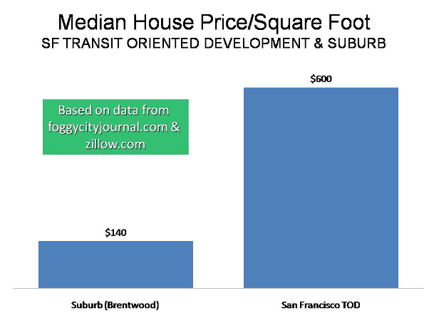
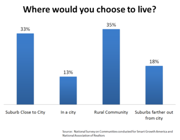
    This pattern will continue to the mid-21st century. The reasons are not hard to identify: Suburbs experience faster job and income growth, far lower crime rates (roughly one-third) and much higher rates of home ownership. While cities will always exercise a strong draw for younger people, the appeal often proves to be short-lived; as people enter their 30s and beyond, they generally prefer suburbs. This pattern will become more pronounced as the huge millennial generation — those born after 1983 — enters this age cohort.

    Over the next few decades, however, suburban communities will evolve beyond the conventional 1950s-style “production suburbs” of vast housing tracts constructed far from existing commercial and industrial centers. The suburbs of the 21st century will increasingly incorporate aspects of preindustrial villages. They will be more compact and self-sufficient, providing office space as well as a surging home-based workforce. Well before 2050 as many one in four or five people will work full or part time from home.

    Surveys of housing preferences consistently show that if given the choice, most Americans, particularly families, will still opt for a place with a spot of land and a little breathing room. And despite the coming population growth, most Americans will probably continue to resist being forced into density, and even with 100 million more people, the country will still be only one-sixth as crowded as Germany.

    The Rise of ‘Cities of Aspiration’

    The continuing appeal of suburbia does not mean that America’s urban centers are doomed. On the contrary, the United States will remain a nation of great cities. Throughout the history of civilization, cities have been engines for social, cultural and economic activity. The market for dense urban existence is likely to remain small compared with suburbs, but there will still be massive opportunities to provide for the roughly 15 million to 20 million new urban dwellers by 2050.

    Some urban areas such as San Francisco, Boston, Manhattan and the western edge of Los Angeles will remain highly attractive to the young, the affluent and the highly skilled, as well as some recent immigrants. After all, these cities contain many of the nation’s most vibrant cultural institutions, research centers, colleges and universities, and much of its most attractive architecture.

    These cities will sit atop the urban economic food chain, somewhat aloof from the rest of country, and will experience modest growth. But for most Americans, the focus of urban life will shift to cities that are more spread out and, by some standards, less intrinsically attractive.

    These new “cities of aspiration” — Phoenix, Houston, Dallas, Atlanta and Charlotte, N.C. — will perform many of the functions as centers for upward mobility that New York and other great industrial cities once did.

    Filling America’s Heartland

    Perhaps the least anticipated development in the nation’s 21st century geography will be the resurgence of the American heartland, often dismissed by coastal dwellers as “flyover country.” But as the nation gains 100 million people, population and cost pressures are destined to resurrect the nation’s vast hinterlands.

    Americans will head out to the hinterlands because they will find opportunities and perhaps a better quality of life. According to recent surveys, as many as one in three American adults would prefer to live in a rural area — compared with the 20-odd percent who actually do. Most Americans perceive rural America as epitomizing traditional values of family, religion and self-sufficiency and as being more attractive, friendly and safe, particularly for children.

    One critical factor in the heartland’s growing relevance is the advent of the Internet, which has broken the traditional isolation of rural communities. As the technology of mass communications improves, the movement of technology companies, business services and manufacturers into the hinterland is likely to accelerate. This will be not so much a movement to remote hamlets, but to the growing number of dynamic small cities and towns spread throughout the heartland.

    The heartland, consigned to the fringes of American society and economy in the 20th century, is poised to enjoy a significant renaissance in the early 21st. Not since the 19th century, when it was a major source of America’s economic, social and cultural supremacy, has the vast continental expanse been set to play so powerful a role in shaping the nation’s future.

    This article originally appeared at AOLNews.com.

    Joel Kotkin is executive editor of NewGeography.com and is a distinguished presidential fellow in urban futures at Chapman University. He is author of The City: A Global History. His newest book is The Next Hundred Million: America in 2050, released in Febuary, 2010.

    Photo: sparktography

  • Forced March To The Cities

    California is in trouble: Unemployment is over 13%, the state is broke and hundreds of thousands of people, many of them middle-class families, are streaming for the exits. But to some politicians, like Sen. Alan Lowenthal, the real challenge for California “progressives” is not to fix the economy but to reengineer the way people live.

    In Lowenthal’s case the clarion call is to take steps to ban free parking. This way, the Long Beach Democrat reasons, Californians would have to give up their cars and either take the bus or walk to their local shops. “Free parking has significant social, economic and environmental costs,” Lowenthal told the Los Angeles Times. “It increases congestion and greenhouse gas emissions.”

    Scarily, his proposal actually passed the State Senate.

    One would hope that the mania for changing how people live and work could be dismissed as just local Californian lunacy. Yet across the country, and within the Obama Administration, there is a growing predilection to endorse policies that steer the bulk of new development into our already most-crowded urban areas.

    One influential document called “Moving Cooler”, cooked up by the Environmental Protection Agency, the Urban Land Institute, the Environmental Defense Fund, Natural Resources Defense Council, the Environmental Protection Agency and others, lays out a strategy that would essentially force the vast majority of new development into dense city cores.

    Over the next 40 years this could result in something like 60 million to 80 million people being crammed into existing central cities. These policies work hard to make suburban life as miserable as possible by shifting infrastructure spending to dense areas. One proposal, “Moving Cooler,” outdoes even Lowenthal by calling for charges of upwards of $400 for people to park in front of their own houses.

    The ostensible justification for this policy lies in the dynamics of slowing climate change. Forcing people to live in dense cities, the reasoning goes, would make people give up all those free parking opportunities and and even their private vehicles, which would reduce their dreaded “carbon imprint.”

    Yet there are a few little problems with this “cramming” policy. Its environmental implications are far from assured. According to some recent studies in Australia, the carbon footprint of high-rise urban residents is higher than that of medium- and low-density suburban homes, due to such things as the cost of heating common areas, including parking garages, and the highly consumptive lifestyles of more affluent urbanites.

    Moreover, it appears that even those who live in dense places may be loath to give up their cars. Over 90% of all jobs in American metropolitan regions are located outside the central business districts, which tend to be the only places well suited for mass transit.

    Indeed, despite the massive expansion of transit systems in the past 30 years, the percentage of people taking public transportation in major metropolitan regions has dropped from roughly 8% to closer to 5%. Even in Portland, Ore.–the mecca for new wave transit consciousness–the share of people using transit to get to work is now considerably less than it was in 1980. In recent months overall transit ridership nationwide has actually dropped.

    These realities suggest that densification of most cities–with the exceptions of New York, Washington and perhaps a few others–cannot be supported by transit. Furthermore, drivers in dense cities will be confronted with not less congestion, but more, which will likely also boost pollution. The most congested cities in the country tend to be the densest, such as Los Angeles, Sen. Lowenthal’s bailiwick, which is in an unenviable first place.

    Then there is the little issue of people’s preferences. Urban boosters have been correct in saying that until recently there have been too few opportunities for middle-class residents to live in and around city cores. But over the past decade many cities have gone for broke with dense condo and rental housing and have produced far more product, often at very high cost, than the market can reasonably bear.

    Initially, when the mortgage crisis broke, the density advocates built much of their case on the fact that the biggest hits took place in suburban areas, particularly on the fringe. Yet as suburban construction ended, cities continued building high-density urban housing–sometimes encouraged by city subsidies. As a result, in the last two years massive foreclosures have plagued many cities, and many condominiums have been converted to rentals. This is true in bubble towns like Las Vegas and Miami; “smart-growth” bastions like Portland and Seattle; and even relatively sane places such as Kansas City, Mo. All these places have a massive amount of high-density condos that are either vacant or converted into lower-cost rentals.

    Take Portland. The city’s condo prices are down 30% from their original list price. The 177-unit Encore, one of the fanciest new towers, has closed sales on 12 of its units as of March, while another goes to auction. Meanwhile in New York half-completed structures dot Brooklyn’s once-thriving Williamsburg neighborhood, while the massive Stuyvesant Town apartment complex in Manhattan teeters at the edge of bankruptcy.

    Finally, it is unlikely that cities would be able to accommodate the massive growth promoted by urban boosters, land speculators and policy mavens. Aaron Renn, who writes the influential Urbanophile blog, says that most American cities today struggle to maintain their current infrastructure. They also have limited options to zone land for high-density construction, due in part to grassroots opposition to existing residential neighborhoods. Overall they would be hard-pressed to accommodate much more than 10% of their region’s growth, much less 50% or 60%.

    Given these realities, and the depth of the current recession, one might think that governments would focus more on basics like jobs and fixing the infrastructure–in suburbs as well as cities–than reengineering how people live. Yet it is increasingly clear that for many “progressives” the real agenda is not enabling people to achieve their dreams–especially in the form of a suburban single-family house. It is, instead, forcing them to live in what is viewed as more ecologically and socially preferable density.

    In the next few months we may see more of the kind of hyperregulation proposed by the likes of Sen. Lowenthal. It is entirely possible that a hoary coalition of HUD, Department of Transportation and EPA bureaucrats could start trying to restrict future housing development along the lines suggested in “Moving Cooler.”

    Yet over time one has to wonder about the political efficacy of this approach. Right now Americans are focused primarily on simply economic growth–and perhaps a touch less on the intellectual niceties of the “smart” form. In addition they are increasingly skeptical about climate change, which serves as the primary raison d’etre behind the new regulatory schema.

    Given the zealousness of the density advocates, perhaps the only thing that will slow, and even reverse, this process will be the political equivalent of a sharp slap across the face. Unless the ruling party begins to reacquaint itself with the preferences and aspirations of the vast majority of Americans, they may find themselves experiencing repeats of their recent humiliating defeat–manufactured largely in the Boston suburbs–in true-blue Massachusetts.

    Americans–suburban or urban–may resist a return to unbridled and extreme Republicanism, whether on social issues or in economic policy. But forced to choose between Neanderthals, who at least might leave them alone in their daily lives, and higher-order intellects determined to reengineer their lives, they might end up supporting bipeds lower down the evolutionary chain, at least until the progressive vanguard regains a grip on common sense.

    This article originally appeared at Forbes.com.

    Joel Kotkin is executive editor of NewGeography.com and is a distinguished presidential fellow in urban futures at Chapman University. He is author of The City: A Global History. His newest book is The Next Hundred Million: America in 2050, released in Febuary, 2010.

    Photo: Creativity+ Timothy K Hamilton

  • The Myth of the Strong Center

    At the height of the foreclosure crisis the problems experienced by some so-called “sprawl” markets, like Phoenix and San-Bernardino-Riverside, led some observers to see the largest price declines as largely confined to outer ring suburbs. Some analysts who had long been predicting (even hoping for) the demise of the suburbs skipped right over analysis to concoct theories not supported by the data. The mythology was further enhanced by the notion – never proved – that high gas prices were forcing home buyers closer to the urban core.

    Yet a summary of the trends over the past 18 months show only minor disparities between geographies within leading urban regions. Overall house prices escalated similarly in virtually all areas within the same metropolitan areas and the price drops appear to have also been similar. This is in contrast to a theory that suggests that huge price drops occurred in the outer suburbs while central city prices held up well.

    Summary of 18 Month Subarea Price Declines: This is indicated by a review of 8 metropolitan areas: Los Angeles, the San Francisco Bay Area, San Diego, Sacramento, Atlanta, Chicago, Portland and Seattle (see end note), for which subarea data is readily available (see table). On average, central area median house prices (all houses, including condominiums), fell 3% in relation to the overall metropolitan area average. Inner suburban areas experienced a 3% gain relative to metropolitan area prices, while outer suburban areas changed at the metropolitan area average. In actual price reduction terms, core areas declined 28.8%, inner suburban areas declined 25.7%, and outer suburban areas declined 27.1%. The overall average metropolitan area decline was 27.2%. There was, however, considerable variation in the figures by metropolitan area (see figure below).

    MEDIAN HOUSE PRICE CHANGES BY GEOGRAPHICAL SECTOR
    8 Metroplitan Areas
    CALIFORNIA MARKETS Central Inner Suburbs Outer Suburbs Overall
    Los Angeles -45.3% -30.0% -41.5% -37.1%
    San Francisco Bay -38.0% -39.1% -38.6% -38.6%
    San Diego -36.5% -37.4% -37.0% -36.9%
    Sacramento -53.6% -36.3% -37.5% -44.0%
    OTHER MARKETS
    Atlanta -11.6% -17.0% -15.8% -15.8%
    Chicago -21.0% -16.3% -17.5% -17.8%
    Portland -10.0% -14.5% -15.7% -13.5%
    Seattle -14.2% -14.7% -13.2% -13.7%
    AVERAGE -28.8% -25.7% -27.1% -27.2%
    Estimated from Data Quick information
    California Markets: July 2008 to January 2010
    Other Markets: 2008-2nd Quarter to 2009-4th Quarter

    Where Central Area Losses were Greatest: Over the past 18 months, central areas posted the largest losses in three of the areas. Further, in each of these areas, the smallest price drops were experienced in the inner suburbs.

    • Sacramento had the steepest central area relative price decline. Central area prices declined 37% relative to inner suburban prices, where the smallest losses occurred. The central area price loss averaged 53.6%, compared to the overall metropolitan area loss of 44.0%. The inner suburbs experienced the smallest loss, at 36.3%.
    • Los Angeles also had a steep central area relative price decline. Central area prices declined 45.3%, compared to the overall metropolitan area loss of 37.1%. The inner suburbs experienced the smallest loss, at 30.0% while outer suburbs lost 41.5%.
    • Chicago’s greatest losses also occurred in the central area, but were of a much smaller magnitude. Central area prices declined 21.0%, compared to the overall metropolitan area loss of 17.8%. The inner suburbs experienced the smallest loss, at 16.3%. The outer suburbs lost 17.5%.

    Where Suburban Losses were the Greatest: In two areas, the central area price losses were the least, Atlanta and Portland. Yet, the magnitude of these losses was modest. It is interesting to note that the metropolitan areas with the smallest relative losses in the central areas pursued radically different policies with respect to development. Portland’s “smart growth” policies favor central development at the expense of suburban development, while Atlanta’s more liberal policies do not attempt to steer development to the core.

    • Atlanta’s greatest price declines occurred in the inner suburbs, which experienced a loss of 17.0%, slightly more than that of the outer suburbs (15.8%). In comparison, the central area price drop was the least, at 11.6%, The metropolitan area loss was 15.8%.
    • Portland’s greatest price declines occurred in the outer suburbs which experienced a 15.7% loss, compared to the inner suburbs, at 14.5. The lowest decline was in the central area at 10.0%. The metropolitan area loss was 13.5%.

    Little Difference in Some Markets: There was little difference in the price declines among geographic sectors in three of the metropolitan areas. In the San Francisco Bay area, San Diego and Seattle, the differences between central, inner suburban and outer suburban price declines were all within a 2% range.

    Core Condominium Market Crisis

    However, core area markets where condominiums predominate indicate substantial difficulties in some of the metropolitan areas. These markets are generally only a small part of central cities, principally around downtown areas or major centers. For example, in the Portland area, the core condominium areas ring the downtown area and include the Pearl District and the South Waterfront District. The central area, which encompasses the entire city of Portland, however, is much larger and has a much larger share of detached housing.

    Demand has been so weak in the core condominium markets that substantial price reductions have occurred and a number of buildings have been forced to sell units at auction. Other buildings have given up altogether on selling and have rented condominiums. Some of the price drops, especially in Atlanta, Portland and Seattle are far greater than occurred overall in the respective metropolitan markets. The condominium implosion has not received nearly the level of attention in the national or local media that was accorded the housing bubble and collapse itself.

    Portland: A local television station video indicates that Portland’s condominium market is in crisis. A report in The Oregonian indicates that the downtown area has a “glut” of condominiums and that February sales prices averaged 30% below list. A luxury new 15-story building in the Pearl District (The Wyatt) is now being leased instead. Units at The Atwater in the South Waterfront district were auctioned, with minimum bid prices more than 50% lower than list. The John Ross, also in the South Waterfront District, is Portland’s largest condominium project and will be auctioning its units. Minimum bid prices average 70% below the previous top list prices. The smallest units have a minimum bid price of $110,000. By comparison, over the past year, the median house price in the Portland metropolitan area has dropped approximately 10%.

    Atlanta: Atlanta has a “vast oversupply” of condominiums. The uptown (including Atlantic Station) and Buckhead markets of Atlanta appear to be experiencing some of the worst market conditions in the nation. The prestigious Mansion on Peachtree, a combination hotel and condominium development, was unable to sell 75% of its residences and was recently sold in foreclosure at approximately $0.30 on the dollar. The winning auction bids at The Aqua condominium in Uptown averaged 50% below the last asking price. In Atlantic Station, units at The Element were auctioned at substantial discounts. Among conventional sales, condominium price reductions of up to 40% have been reported. One building has offered discounts of $100,000 per bedroom. Some new buildings have been converted to rentals, while planned projects have been placed upon hold.

    Seattle: Things are little better in Seattle. The overbuilt downtown area condominium market has experienced a median price decline of 35% over the past year. Units at The Gallery in tony Belltown were auctioned off at minimum prices 50% below the last list prices (which had already been discounted). Units at The Brix, on Capitol Hill, attracted bids at auction averaging 30% below previous list prices. Later this month, unsold units at 5th & Madison will be auctioned, at minimum prices below 50% of previous list. For comparison, median house prices in the Seattle metropolitan area declined 6% over the past year.

    Chicago: The downtown area of Chicago has been among the most vibrant condominium markets for more than a decade. However, in 2009, condominium sales fell to the lowest level since 1997. At current sales rates, the downtown area has a supply of more than five years, with annual sales of less than 600 and more than 3,000 units available or under construction.

    Los Angeles: Few markets have seen as many condominium buildings planned as downtown Los Angeles, and few have seen so many put on hold. A recent issue of the Los Angeles Downtown News lists approximately 50 downtown condominium projects. More than three-quarters of the projects have been scaled back, have had construction slowed or are on “hold.” The market has been so weak that a number of developers have taken losses by auctioning condominium units that they have not been able to sell conventionally.

    San Diego: The downtown San Diego condominium is substantially overbuilt. Developers have leased units that were to have been sold and there is virtually no construction of new units.

    Rental Conversions: Even these grim reports, however, may mask an even bigger problem. It is estimated that more than 20,000 condominiums units are completed or nearly completed, but are not listed for sale in Miami. In what is by far the nation’s strongest condominium market, Manhattan, more than 6,000 condominium units are completed or nearly completed, but not listed for sale.

    In core cities, few issues have been as divisive as the conversion of rental units to condominiums. But, now the opposite is now occurring – condominiums are being converted into apartments for rent: This is trend that undermines markets in a way that cannot be measured by median prices, since it replaces generally high-paying condo owners for generally less flush renters. This puts those who bought at higher prices in these markets at a particular disadvantage.

    Conclusion: Overall, contrary to the mythology developed early in the bubble, suburbs and even exurbs have generally performed about as well as closer in markets. The big imponderable will be the future of the core condominium market, which is experiencing significant financial reverses largely ignored by the national media.


    Note: As used in this article, the Los Angeles metropolitan area is the Los Angeles-Riverside Combined Statistical Area, the San Francisco area is the San Francisco-San Jose Combined Statistical Area and all other metropolitan areas are the corresponding metropolitan statistical areas. http://demographia.com/db-prdistr2010.pdf>Subareas defined.

    Photograph: Condominium construction, Atlanta, weekend of the Lehman Brothers collapse.

    Wendell Cox is a Visiting Professor, Conservatoire National des Arts et Metiers, Paris. He was born in Los Angeles and was appointed to three terms on the Los Angeles County Transportation Commission by Mayor Tom Bradley. He is the author of “War on the Dream: How Anti-Sprawl Policy Threatens the Quality of Life.

  • Transit Oriented Development: If Not San Francisco, Where?

    “The Great Transit Oriented Development Swindle?” reads the headline in the Fog City Journal, one of the growing number of internet newspapers providing serious, professional web-based journalism as an alternative to declining print newspapers (and their often less than effective web sites).

    The article does not directly answer the question in the headline, but certainly provides enough ammunition to what has become a commonly accepted mantra among planners and urban boosters. It reveals how transit oriented development (TOD) is often based upon fragile foundations that amount to an ideological swindle. It is important to recognize that the Fog City Journal is no right wing or libertarian organ. There is little market for that in the city of San Francisco. The leftish bent of the Fog City Journal, combined with author Marc Salomon’s unusually incisive (and footnoted) analysis makes this article noteworthy. It also seems clear that the author is a proponent of more transit service and funding, not less – even though he is highly skeptical about the current TOD craze.

    Transit Oriented Development: The idea behind transit oriented development is that, in new, higher density developments, people use transit more and cars less. Transit oriented development has become a first principle of some, who seem to believe that cities can become vibrant in part by strangling new suburbs out of existence. Transit oriented development is at the very heart of the Obama Administration’s “livability agenda,” and is frequently cited admiringly by Secretary of Transportation Ray LaHood.

    Eastern Neighborhoods: Salomon’s subject is San Francisco’s Eastern Neighborhoods, where transit oriented development is proposed. From the beginning Salomon identifies a fundamental problem: “Transit Oriented Development is predicated upon the notion that existing transit infrastructure is attractive enough such that residents of new units will take transit to work instead of drive. He continues: “The existing transit system, both regional and local, is not capable of handling existing demand.”

    Salomon correctly notes that “San Francisco is not the regional employment center.” In fact, nearly 90% of employment in the San Francisco-San Jose area is not in downtown San Francisco. Indeed, Silicon Valley, not downtown San Francisco, has long been the largest employment center in the area and there are also major job concentrations in the suburban belt east of Oakland.

    No Better Place for Transit Oriented Development: Yet, there are few places in the world better served by transit than the Eastern Neighborhood transit oriented development. The project is no more than a long walk from downtown San Francisco (Figure 1). Residents will be able to access frequent “Muni” bus services. The development would be well served by BART (the regional metro), midway between two stations, both of which access four routes. There are few places in the world where a non-transfer station serves that many routes. Salomon analyzes transit from the center of the development, the corner of Mission and 20th Streets.

    Transit Oriented Development: Forcing Longer Commutes: Salomon’s concern starts with the recognition that these systems are already overcrowded. However there is more. Even with their heavy (and highly subsidized) loads, the virtually unparalleled level of transit service available from Mission and 20th cannot compete with the automobile. Salomon’s analysis shows that, on average, transit oriented development residents working at jobs at the 30 largest firms in the San Francisco Bay area would spend nearly 3.5 as much time traveling to work by transit than if they drove themselves. The best transit travel time would be more than double the auto travel time, while the worst would near five times (Figure 2).

    Transit Oriented Development: Making Traffic Congestion Worse: Mirroring the research on the association between higher densities and greater traffic congestion, Salomon suggests that without substantial additional transit spending, transit oriented development “in San Francisco will most likely diminish transit reliability by increasing auto trips–the precise opposite of transit oriented development’s stated goals.” On this point, however, it is well to remember that no transit system has ever been seriously conceived, much less proposed or implemented that could provide competitive mobility between Mission and 20th and the dispersed employment throughout the San Francisco Bay Area. A transit system that reaches all of the dispersed employment in a modern American or European urban area at travel times competitive with the car could require annual expenditures that approach or even exceed the gross domestic product of the area.

    Unaffordable Transit Oriented Development: But Salomon is not through. Insufficient transit service is only part of the problem. There is a fundamental problem with the thesis that “cities need to densify their urban cores to support greater densities of development.” But, he says, “this is predicated upon the assumption that housing in the urban core and periphery are fungible, that the core and periphery compete interchangeably for buyers.”

    Unlike most urban advocates and the Secretary of Transportation, it is apparent that Salomon understands the first principle of “livability.” Livability requires affordability. In San Francisco suburb of Brentwood, for example, Salomon notes that the median house price is $298,000. Brentwood is located in eastern Contra Costa County, approximately 50 miles from downtown San Francisco. But there is no need to travel that far, since there is an abundance of jobs much closer.

    This compares to a median price of $627,000 for an apartment/condominium near the proposed transit oriented development in San Francisco. Further, the house in Brentwood will be more than double the size of condo in the transit oriented development, as data from zillow.com indicates. Thus, the new home buyer will pay less than one-fourth the cost per square foot in Brentwood compared to the transit oriented development (Figure 3). The Brentwood household will also enjoy a backyard that would not come with a 23rd floor flat.

    Lifestyles of the Few: None of this is to suggest that transit oriented development cannot be attractive. The mistake, however, is the outsized enthusiasm of its proponents. Like a Mini Cooper or sportscar, transit oriented development serves the needs and wants of a narrow niche market, but by no means anything close to the majority.

    Salomon concludes:

    In order for transit oriented development to check sprawl, prospective home buyers would be expected to make the choice between purchasing a $300K unit in Brentwood or a unit costing twice that much in San Francisco. Further, in order to check motor vehicle commutes, the assumption would be that someone paying that urban location premium would more than double their commute time by taking transit.

    Simply stated, many of the claims of transit oriented development proponents simply do not “pencil out.” TOD residents will have to drive, unless their jobs are within walking distance. Further, in the dynamic economy that has developed in US urban areas, few can assume that they will always work in the same place. Most importantly, however, very few suburbanites could afford the tony TODs. That’s not a problem, however, since most of them are probably not sorely tempted.

    Photograph: Market Street Toward the Ferry Building, San Francisco

    Wendell Cox is a Visiting Professor, Conservatoire National des Arts et Metiers, Paris. He was born in Los Angeles and was appointed to three terms on the Los Angeles County Transportation Commission by Mayor Tom Bradley. He is the author of “War on the Dream: How Anti-Sprawl Policy Threatens the Quality of Life.

  • The Forty-Fifth Parallel

    When I was a kid growing up in Oregon, we’d occasionally drive north on I-5 to Portland. Just north of Salem we’d pass a sign that read (if memory serves) “The 45th Parallel: Halfway between the equator and the north pole.”

    I wish I’d stopped and taken a picture of myself straddling the parallel. It would go with a collection of similar straddles: across the equator in Uganda, across the Arctic Circle in Finland, and across the 42nd parallel.

    Yes, for if you go south on I-5 (or almost any other road) the 42nd parallel, 7/15ths of the way from the equator to the north pole, is very well marked. It says “Welcome to California.” For 42 is the southern boundary of Oregon and Idaho, against California, Nevada and Utah. Likewise, heading south from Syracuse on I-81, just past Binghamton, it’s marked as “Welcome to Pennsylvania.”

    Other latitudes form important state lines: the four corners is at the 37th parallel and the 109th meridian. Colorado’s northern boundary follows the 41st parallel. And famously, the 49th parallel comprises the largest part of the US-Canada border.

    The special 45th parallel, however, is explicitly reflected in political geography in only two places: it forms Montana’s southern boundary with Wyoming. And more significantly, it forms the northern boundary of New York and Vermont against Quebec.

    Only four states lie entirely north of the 45th parallel: Alaska, Washington, Montana (almost), and North Dakota. The biggest cities are Seattle and Portland. The parallel divides the Minneapolis-St. Paul area. So counting six million from Washington, 2 million each from Oregon and Minnesota, and about 3 million from everywhere else, approximately 13 million Americans live north of the 45th parallel – or 4% of our population.

    Now consider Canada. That country’s southernmost reach is Middle Island in Lake Erie, just south of the 42nd parallel. (My mother often told me that Canada was south of California.) The 45th parallel passes north of Barrie, Ontario, which means the Toronto Metro area and Western Ontario are to the south. Further east, St. John, NB lies just to the north, but Halifax, NS is just to the south. Montreal, Ottawa, and all western cities are north of 45. I’ll guess that about 25 million of Canada’s 34 million people live north of the 45th – about 74% of the population.

    So while almost all Americans live to the south, a large majority of Canadians live to the north. So if one wants to distinguish the US from Canada by a single straight line, the 45th is as good as any. It is much better than the iconic 49th, since the largest Canadian cities are well south of that latitude.

    Heading east, the 45th passes through the southern tip of Crimea, and splits Kazakhstan and Mongolia in half. The only parts of Russia lying south are Vladivostok and the northern Caucasus. Japan, China and the Central Asian republics are almost all to the south.

    In Europe, the parallel runs through Southern France and Northern Italy. To a very rough approximation, it follows the Pyrenees-Alps mountains. In the continental EU, only Bulgaria, Greece, Spain and Portugal lie entirely to the south.

    The parallel wouldn’t have been the worst way to split up the former Yugoslavia: Zagreb is to the north, and Belgrade in the south. Further, the Serbian region of Vojvodina and the Romanian region of Transylvania are north. These areas both have large Hungarian minorities, formerly part of the Austro-Hungarian empire. Irredentist movements in Hungary might happily settle for a boundary at the 45.

    A reasonable population estimate for north of the 45th counts 200 million in the former USSR, 370 million in Europe, and 30 million in Canada, for a total of 600 million, or 10% of the world’s population.

    If the earth were a perfect sphere, then 29.3% of the surface area of the northern hemisphere would lie north of the parallel (this is a reasonably straightforward calculus problem; try it if you’re so inclined). As the earth is actually an ellipsoid, the number is somewhat smaller. Since about 5 billion people live in the Northern Hemisphere, only about 12% of them live north of 45. (Only about one million people live south of 45 S.)

    Is this surprising? Not really – one wouldn’t expect many people to be living at the north pole. But come to think of it, you’ll be surprised by how surprising this number really is.

    A reasonable rule of thumb is that cities at the same latitude will have the same average annual temperature, as they get the same amount of sunshine at the same times. Thus while Minneapolis certainly has colder winters and hotter summers than Portland, on average it should come out right. I learned this again on my last visit to Portland – summer nights in Portland are cold!

    But the rule of thumb doesn’t apply when something truly bizarre affects the climate. And that bizarre thing is the Gulf Stream, which heats Europe 5+ degrees latitude more than it should. Thus Milan (at 45) has a San Francisco climate; London, Paris and Berlin feel like Portland; Oslo, Helsinki and St. Petersburg are similar to Vancouver; and even Murmansk can’t be worse off than Anchorage.

    Thus the surprise is not how few people live north of 45, but rather how many. For of the 600 million northerly souls, only 5% of them live in North America. That means that subarctic Eurasia has nearly 20 times the population, but probably only 3 times the land area. Thus there is a seven-fold higher population density in northern Eurasia than there is in North America. I’m surprised.

    To quantify the surprise, the appropriate Gulf Stream comparison line through Europe might be at the 52nd parallel rather than 45. I chose that latitude as it roughly corresponds to the Baltic coast. Thus France, Germany, Benelux, Ukraine, Poland, and major parts of European Russia lie between 45 and 52, along with smaller countries. Estimating that combined population at about 400 million, and subtracting that from the 600 million, we get a more reasonable sub-arctic population estimate of about 200 million.

    So 200 million live in the northerly Eastern hemisphere, and 35 million live in Canada – a ratio of nearly six to one. I’m still surprised, but can no longer account for the discrepancy. Is life really that much easier in Finland?

    There is another half-way latitude worth mentioning. What latitude splits the earth’s surface in half? If you did the above calculus assignment, you will immediately know the answer: the 30th parallel. Half the earth’s surface lies within 30 degrees of the equator, and half beyond. The 30th parallel does not correspond to any political geography – it goes through Jacksonville, Baton Rouge, Beaumont, and Austin, before entering Mexico southeast of El Paso.

    So the United States mostly lies between the 30th and 45th parallels. Now isn’t that just the very best of temperate climes?

    Daniel Jelski is Dean of Science & Engineering State University of New York at New Paltz.

  • New Traffic Scorecard Reinforces Density-Traffic Congestion Nexus

    Inrix, an industry provider of traffic information, has just published its third annual Traffic Scorecard, which ranks the nation’s 100 largest metropolitan areas based upon the intensity of their peak hour traffic congestion in 2009. The results provide further evidence of the association between higher urban population densities and more intense traffic congestion.

    Los Angeles, Again: Not surprisingly, Los Angeles is again the most congested metropolitan area over 1,000,000 population. In Los Angeles, roadway travel takes nearly 34.7% more in peak periods than when there is no congestion. This means that a trip that would take 30 minutes without congestion would take, on average 40.5 minutes during peak periods.

    The principal measure used by Inrix is the Travel Time Index, which was developed by the Texas Transportation Institute (TTI), for its congestion reports that started in 1982. TTI’s latest Urban Mobility Report is for 2007. The Inrix measures are developed from actual GPS vehicle readings. This information is also provided to TTI to assist in preparation of its annual Urban Mobility Report.

    Measuring Delay: In the new edition, Inrix switches from using the Travel Time Index to what it calls the Travel Time Tax. The difference between the two measures is that the Travel Time Tax measures the percentage of delay, such as 35% in Los Angeles, while the Travel Time Index would state the figure as 1.35. The new method is preferable because differences in traffic congestion are more readily apparent. . For example, a metropolitan area having a Travel Time Tax of 15% would have 50% worse traffic congestion than a metropolitan area having a Travel Time Tax of 10%. This large difference is not as obvious when comparing the Travel Time Index values of 1.15 and 1.10. The “Travel Time Tax” parlance, however, is less than optimal and this article will use “average congestion delay” instead.

    Ranking the Metropolitan Areas: The average congestion delay in Los Angeles was much worse than in the other largest metropolitan areas, just as its core urban area density is well above that of anywhere else in the US, including New York (where far less dense suburbs more than negate the density advantage in the core city). It also doesn’t help that a number of planned freeways were cancelled in Los Angeles over the last 50 years.

    Among the large metropolitan areas, Washington, DC had the second worst Average congestion delay, at 22.4%, followed by San Francisco, at 21.5%, Austin at 20.7% and New York at 19.7%. Austin may seem to have placed surprisingly high, however this was the nation’s last large metropolitan area to open a full freeway to freeway interchange and has only recently begun to develop a comprehensive freeway system, through the addition of toll roads. Austin’s late roadway development is the result of two factors. Austin was too small in 1956 to receive a beltway under the interstate highway system and an anti-freeway movement delayed construction for decades.

    Inrix also develops an average congestion delay for the worst commuting hour. Los Angeles also has the most congested worst hour, with an average congestion delay of 69%. Austin ranked second worst at 55%, while San Francisco was third at 46%, Washington, DC fourth at 45% and New York fifth at 44%.

    Honolulu: Almost as Bad as Los Angeles: Smaller metropolitan areas also exhibited intense traffic congestion. Honolulu had an average congestion delay nearly as bad as Los Angeles, at 32.4% and a worst hour average congestion delay of 64%. The core urban area of Honolulu has the highest density of any metropolitan area between 500,000 and 1,000,000 population. New York exurb Bridgeport-Stamford had a worst hour average congestion delay of 63%, with a peak period average congestion delay of 18.0%.

    Inrix: Density and Traffic Congestion: Virtually all of the congestion and most of the analyzed road mileage is in the urban areas, rather than in the rural areas that make up the balance of the metropolitan areas. The metropolitan areas with more dense urban areas tend to have worse traffic congestion, as the table below indicates.

      • Metropolitan areas with core urban densities (see Note 1) of more than 4,000 per square mile had peak period average congestion delays of 18.4%, which is more than three times that of metropolitan areas with core urban densities of less than 2,000 (5.9%).

      • Metropolitan areas with core urban densities of more than 4,000 per square mile had worst peak hour average congestion delays of 37.5%, which is nearly 2.4 times that of metropolitan areas with core urban densities of less than 2,000 (15.9%).

    These relationships are similar to those indicated in the Texas Transportation Institute data for 2007.

    Traffic Congestion & Urban Density in the United States: 2009
    Core Urban Area Density (2000) Peak Period Average Congestion Delay: 2009 Compared to Least Dense Category Worst Hour Average Congestion Delay: 2009 Compared to Least Dense Category
    Over 4,000 18.4% 3.26 37.5% 2.36
    3,000-3,999 10.0% 1.76 22.3% 1.41
    2,000-2,999 7.3% 1.30 17.7% 1.12
    Under 2,000 5.6% 1.00 15.9% 1.00
    Density: Population per square mile
    Travel Time Tax: Additional travel time required due to traffic congestion
    2000 population density is the latest reliable data
    Calculated from INRIX & 2000 Census data

    Sierra Club Data Also Shows Nexus: Moreover, the association between higher densities and greater traffic congestion is indicated by the ICLEI-Local Governments for Sustainability Density-VMT Calculator, which is based upon Sierra Club research. According to the Calculator, under the “smart growth” scenario, residential housing would be 15 units per acre, as opposed to its “business as usual” scenario at a typical density of four housing units per acre. The density of traffic (vehicle miles per square mile) under the higher density “smart growth” strategy would be 2.5 times as high as under the “business as usual” scenario (Figure).

    The Inevitable Comparisons: Invariably, analysts (smart growth advocates and me) like to point out relationships between Portland, with its “smart growth” policies and Atlanta, the least dense major urban area in the world. The Inrix data shows Portland to have an average peak hour delay of 12.2%, which is 15% worse than Atlanta (10.6%). Portland is nearly twice as dense as Atlanta, while Atlanta’s traffic congestion is made worse by one of the most decrepit freeway and arterial systems in the nation.

    A National Vision: Inrix has also developed a monthly national congestion delay factor. Inrix notes that traffic congestion had been improving as driving declined due to the Great Recession. However, Inrix refers to reduction in driving as “lucky,” and notes that without a “national vision” that “includes addressing congestion as a national priority,” greater traffic congestion will result.

    There is indeed good reason to address traffic congestion. As David Hartgen and M. David Fields have shown, there is a strong relationship between the higher levels of mobility that occur with less congestion and greater economic growth. Obviously that relationship extends to higher urban densities, which are associated with economically counter-productive levels of traffic congestion.

    But there is more than jobs and the economy. More intense traffic congestion produces more intense air pollution as well as more greenhouse gas emissions. It is well to remember that public health was the rationale for air pollution regulation. Air pollution’s negative impacts are so local that they are measured in the quality of life of individual people, especially those in close proximity to unnecessarily overcrowded roads. It is ironic that the higher density promoted by smart growth advocates exposes urban residents to more intense air pollution.


    Note 1: 2000 core urban area (urbanized area) population densities are used in this analysis because there is no later reliable information. The next reliable urban area density data will be a product of the 2010 census. The Federal Highway Administration (FHWA) produces later urban area density figures, many of which are substantially inconsistent with those of the United States Bureau of the Census, which is the primary source of such information. For example, as late as 2005, FHWA reported the Houston urban area to have 1.3 million fewer people than the Bureau of the Census, while reporting a land area nearly 250 square miles larger than the census had measured. Of course, this is a physical impossibility. The result was that Houston’s density was overstated by 45%.

    Note 2: Inrix also ranks metropolitan areas using an “overall congestion” measure, which is simply all congestion added up. As a result, the overall congestion measure is heavily weighted by population. This is illustrated by comparing Los Angeles and Honolulu. These metropolitan areas have very similar average congestion delays, as noted above. This means that drivers encounter similar traffic delays during peak in Los Angeles and Honolulu. However, Honolulu’s overall congestion measure is 95% less than that of Los Angeles, principally driven by the fact that Honolulu’s population is 93% less. As such, the overall congestion measure is of little relevance to people in their day to day commute or as a comparative measure of the intensity of congestion between areas.

    Photograph: Los Angeles City Hall.

    Wendell Cox is a Visiting Professor, Conservatoire National des Arts et Metiers, Paris. He was born in Los Angeles and was appointed to three terms on the Los Angeles County Transportation Commission by Mayor Tom Bradley. He is the author of “War on the Dream: How Anti-Sprawl Policy Threatens the Quality of Life.

  • Decentralize The Government

    From health care reform and transportation to education to the environment, the Obama administration has–from the beginning–sought to expand the power of the central state. The president’s newest initiative to wrest environment, wage and benefit concessions from private companies is the latest example. But this trend of centralizing power to the federal government puts the political future of the ruling party–as well as the very nature of our federal system–in jeopardy.

    Of course, certain times do call for increased federal activity–legitimate threats to national security or economic emergencies, such as the Great Depression or the recent financial crisis, for example.

    Other functions essential to interstate commerce–basic research, science education, the guarantee of civil rights, transportation infrastructure, as well as basic environmental health and safety standards–also call for federal oversight. Virtually every modern president, from Roosevelt and Eisenhower to Reagan and Clinton, has endorsed these uses of centralized government.

    But what is happening now goes well beyond the previously defined perimeters of the federal government’s powers. Obama seems to possess a desire not so much to fix the basic infrastructure of the country but to re-engineer our entire society into the model championed by liberal academia.

    There also seems to be a conscious design to recreate the country as a European-style super-state. Forged by an understandable urge to minimize chaos after a century of conflict, the super-state generally favors risk management through centralization of authority. This has traditionally been accomplished by ceding regulatory powers to national capitals, though lately more and more powers have been ceded to the European Union.

    Initially the administration had hopes of imposing similar controls through acts of Congress. However, with the shifting political mood, this seems less and less possible. With its latest action the administration sends the message that it will now impose the desired results through the bureaucracy. Under the proposal, private firms that do not raise wages will be bullied into doing so through the manipulation of federal contract awards.

    This marks a departure from our basic traditions. For most of our history the burden of expanding opportunity has rested with the private economy, albeit in conjunction with often necessary protections for workers and consumers. Now the overall control of the economy is shifting to Washington–from government contracts to ownership shares in companies like General Motors and much of the financial sector.

    This new order would transform the very nature of American capitalism. Now the economic winners will not be those working for the most agile or profitable companies, but those who gain the blessings of the federal overlords. In some senses this extends the corrupt, largely failed political economy of Chicago politics to a bastard American form of French dirigisme.

    Climate change provides another critical and necessary rationale for the expansive federal role. With the “cap and trade” system all but dead, the administration now wants to regulate energy and land use through the gentle graces of a largely unaccountable EPA apparat. As a result, we may see energy use, land use and transportation–as is increasingly the case in California–controlled by the whims of the unelected bureaucracy.


    Such command and control approaches have their advantages in making people do what the mandarins demand. This is one reason there are so many admirers of Chinese autocracy now. In that regime, unlike our messy democracy, you can be forced to be green in precisely the way they tell you. There are always firing squads for those who go off the program.

    Of course, even the most passionate centralists don’t advocate adopting the Chinese model. But the notion of an enlightened super-state has long appealed to those disgusted with American-style muddling through. In some ways, the current fashion recalls Americans’ attraction for the Soviet Union or even fascist Italy during the troubled 1930s.

    Fortunately, most Americans do not appear ready for unbounded autocracy. This is particularly true outside the coastal urban centers. The Tea Party may have some cranky–even ill-advised–ideas, but they reflect a genuine–and broader–American preference for solving problems at the state or local level.

    Indeed, Americans, including some on the left, are instinctive decentralists. We express this tendency physically, first in our decades-old movement to the suburbs, and increasingly to smaller towns and cities as well as rural areas. Even in cities like New York or Los Angeles, local neighborhood identity trumps ties to more grandiose visions of City Halls or regional bodies. The rise of the Internet and social networks has enhanced this decentralizing trend by providing instant linkages and helping ad hoc organization among neighbors.

    Economic evolution mirrors this trend. Over the past few decades U.S. employment has shifted not to mega corporations but to smaller units and individuals; between 1980 and 2000 the number of self-employed individuals expanded 10-fold to include 16% of the workforce. The smallest businesses–the so-called micro enterprises–have enjoyed the fastest rate of growth, far more than any other business category. By 2006 there were some 20 million such businesses, one for every six private sector workers.

    America’s entrepreneurial urge, in contrast to developments elsewhere, has actually strengthened. In 2008 28% of Americans said they had considered starting a business–more than twice the rate for French or Germans. Self-employment, particularly among younger workers, has been growing at twice the rate of the mid-1990s.

    The remarkable volatility within even the largest companies has exacerbated this trend. Firms enter and leave the Fortune 500 with increasing speed. More and more workers will live in an economic environment like that of Hollywood or Silicon Valley, with constant job shifts, changes in alliances between companies and the growth of job-hopping “gypsies.” Although hard times could slow new business formation, historically recessions have served as incubators of innovation and entrepreneurship.

    Much of the most dynamic and meaningful change takes place under the radar of both big business and government. The shift to greater localism can be seen in the growth of local, unaffiliated community churches, regional festivals and farmers markets. Bowling clubs and old men’s clubs may be fading, but volunteerism has spiked among millennials and seems likely to surge among baby boomers. In 2008 some 61 million Americans volunteered, representing over a quarter of the population over 16.

    No other major country exhibits this kind of localized, undirected activism. Such vital grassroots may become even more important as the country becomes more diverse. In the coming decades we will have to accommodate an expanding range of locally preferred lifestyles, environments, ethnic populations and politics. One size determined by mandarins in Washington increasingly will not fit all. South Dakotans and San Franciscans will prefer to address similar problems in different ways. Within the limits of constitutional rights, we should let them try their hand and let everyone else learn from their success (or failure).

    Ultimately, we do not want to recreate the expansive mandarin state so evident in many foreign countries. Instead, we should focus more on family, community, neighborhoods, local jurisdictions and voluntary associations–what Thomas Jefferson called our “little republics”–as the most effective engines driving toward a better future.

    This article originally appeared at Forbes.com.

    Joel Kotkin is executive editor of NewGeography.com and is a distinguished presidential fellow in urban futures at Chapman University. He is author of The City: A Global History. His newest book is The Next Hundred Million: America in 2050, released in Febuary, 2010.

  • Eminent Domain as Central Planning

    Free markets are out of vogue. The unfortunate lesson that policymakers have learned over the past two years is that a big, brainy government that supposedly creates jobs is superior to irrational, faceless markets that just create catastrophic errors. So Washington has seized on the financial and economic crises to enlarge its role in managing the economy—controlling the insurance giant AIG, for example, and trying to maintain high housing prices through tax credits and “mortgage modification” programs.

    But when it comes to central economic planning, New York City and State are way ahead of the feds. Empire State politicians from both parties already believe that it’s their responsibility to replace people and businesses in allocating the economy’s resources. They’re even confident that their duty to design a perfect economy trumps their constituents’ right to hold private property. Three current cases of eminent-domain abuse in New York show how serious they are—and how much damage such government intrusiveness can wreak.

    Brooklyn’s Prospect Heights, industrial and forlorn for much of the late twentieth century, was looking better by 2003. Government was doing its proper job: crime was down, and the public-transit commute to midtown Manhattan, where many Brooklynites worked, was just 25 minutes. That meant that the private sector could do its job, too, rejuvenating the neighborhood after urban decay. Developers had bought 1920s-era factories and warehouses and converted them into condos for buyers like Daniel Goldstein, who paid $590,000 for a place in a former dry-goods warehouse in 2003. These new residents weren’t put off by the Metropolitan Transportation Authority’s railyards nearby, and they liked the hardwood floors and airy views typical of such refurbished buildings. They also settled in alongside longtime residents in little houses on quiet streets. Wealthier newcomers joined regulars at Freddy’s, a bar that predated Prohibition. Small businesses continued to employ skilled laborers in low-rise industrial buildings.

    But Prospect Heights interested another investor: developer Bruce Ratner, who thought that the area would be perfect for high-rise apartments and office towers. Ratner didn’t want to do the piecemeal work of cajoling private owners into selling their properties, however. Instead, he appealed to the central-planning instincts of New York’s political class. Use the state’s power to seize the private property around the railyards, he told Governor George Pataki, Mayor Michael Bloomberg, and Brooklyn borough president Marty Markowitz. Transfer me the property, and let me buy the railyards themselves below the market price. I’ll build my development, Atlantic Yards, around a world-class basketball arena.

    New York, in short, would give Ratner an unfair advantage, and he would return some of the profits reaped from that advantage by creating the “economic benefits” favored by the planning classes. Architecture critics loved Frank Gehry’s design for the arena. Race activist Al Sharpton loved the promise of thousands of minority jobs. The Association of Community Organizations for Reform Now (Acorn) loved the prospect of administering the more than 2,000 units of “affordable” housing planned for the development, as well as the $1.5 million in loans and grants that Ratner gave it outright. When the state held public hearings in 2006 to decide whether to approve Atlantic Yards, hundreds of supplicants, hoping for a good job or a cheap apartment, easily drowned out the voices of people like Goldstein, who wanted nothing from the government except the right to keep their homes.

    Can New York legally seize private property and transfer it to a developer purely for economic development? The Fifth Amendment to the U.S. Constitution allows the government to take property for a “public use,” long understood to mean such things as roads and railways, so long as it makes “just compensation” for them. Starting around the 1930s, a number of court cases began to broaden “public use” to include more nebulous “public purposes,” such as slum clearance. And in 2005, in Kelo v. New London, the Supreme Court decided that these “public purposes” could even include economic development. But New York’s constitution theoretically holds the state to a higher standard. In 1967, Empire State voters voted not to add a “public purpose” clause to their constitution, preferring to stick with the stricter requirement of “public use.”

    The state hasn’t let this inconvenience derail its plans for Prospect Heights, however. For seven decades, courts have let New York seize and demolish slum housing if it’s blighted—which New York State defines as “substandard” and “unsanitary.” So the Urban Development Corporation (UDC), a public entity of New York State, decided that the “public use” of Atlantic Yards would be blight removal. The city had already designated part of the neighborhood as “blighted” 40 years earlier, long before its resurgence. As for the rest, the UDC commissioned consultants—previously employed by Ratner—who soon returned the requisite blight finding.

    But wait, you say: people don’t buy half-million-dollar apartments in “substandard” or “unsanitary” neighborhoods. You’re right; that’s why the consultants had to stretch. In the 1930s, as Goldstein’s attorney, Matthew Brinckerhoff, pointed out, “substandard” and “unsanitary” meant “families and children dying from rampant fires and pestilence” in tuberculosis-ridden firetraps. In 2006, by contrast, the UDC’s consultants found “substandard” conditions in isolated graffiti, cracked sidewalks, and “underutilization”—that is, when property owners weren’t using their land to generate the social and economic benefits that the government desired.

    In New York, this creative definition of blight is the new central-planning model. Consultants have also cited “underutilization” in West Harlem, where the city’s Economic Development Corporation wants to take land from private owners and hand it to Columbia University for an expansion project. Says Norman Siegel, who represents the owners: “A private property owner has the right to determine the best productive use of his property. It’s not a right to be ceded to any government.”

    And in Queens, the Bloomberg administration is preparing a similar argument to grab swaths of Willets Point, an area adjacent to Citi Field that’s populated with auto-repair shops. The city’s recent “request for qualifications” from would-be developers drew a sharp response from the people who owned the land: “We . . . hold the most significant qualification of all: we own the properties. We are motivated to improve and use our own properties, consistent with the American free market system. We would have done so in spectacular fashion already, had the city upheld its end of the bargain by providing our neighborhood with essential services and infrastructure.” Instead, the city has done the opposite, letting streets disintegrate into ditches to bolster its blight finding. The perversity is astonishing: rather than doing its own job of maintaining public infrastructure and public safety, the government wants to do the private sector’s job—and is going about it by starving that private sector of public resources.

    Property owners have looked to the judiciary to check the overweening grasp of the legislative and executive branches. But courts can be wrong for longer than it takes to save a neighborhood. In Brooklyn, Goldstein and his neighbors have lost their lawsuits—most recently, in New York’s highest court, the court of appeals. In November, the court decided 6–1 that “all that is at issue is a reasonable difference of opinion as to whether the area in question is in fact substandard and insanitary. This is not a sufficient predicate for us to supplant [the state’s] determination.” The court essentially abdicated its duty to protect property owners from the governor and the Legislature.

    Nine days later, the West Harlem owners fared better in a lower court. The first department of the state supreme court’s appellate division found, 3–2, that the blight studies that the city and state had commissioned to justify their rapacity were “bereft of facts”—and further tainted by the fact that one blight consultant also worked for Columbia. The blight designation “is mere sophistry,” the majority concluded, “hatched to justify the employment of eminent domain.” The court further noted that “even a cursory examination of the study reveals the idiocy of considering things like unpainted block walls or loose awning supports as evidence of a blighted neighborhood. Virtually every neighborhood in the five boroughs will yield similar instances of disrepair.”

    The selective and arbitrary process that deems one neighborhood blighted while leaving a similar neighborhood alone also violates due process, the justices went on, as “one is compelled to guess what subjective factors will be employed in each claim of blight.” Another violation: the government responded poorly to property owners’ document requests under the state’s freedom of information law, hampering their right to mount a solid case. Such requests are particularly important in eminent-domain cases because New York property owners don’t enjoy the right to a trial with a discovery phase, but must go straight to appeals court—a seventies-era “reform” meant to speed up development projects.

    The Harlem owners were able to convince the lower court partly because they had commissioned their own “no-blight” study. “We said, ‘Let’s create our own record . . . as a counterweight,’ ” said Siegel. The owners also presented as evidence a government study, performed before Columbia showed interest in the land, that West Harlem was revitalizing itself. This is all very well—but property rights shouldn’t depend on owners’ creativity and resourcefulness in proving beyond all reasonable doubt that their land isn’t blighted.

    Further, the lower-court ruling is a tenuous victory. The case is proceeding to the court of appeals, and though Siegel is “cautiously optimistic” that it will rule in his clients’ favor, there’s no way to be sure. Meantime, Goldstein and fellow residents and business owners in Brooklyn have asked the court of appeals to reconsider its Atlantic Yards ruling after it rules on Harlem. But the starkly different decisions in the Harlem and Brooklyn cases, coming so close together, have pointed up the need for the Legislature and Governor David Paterson to create clear standards for the government’s power to seize property.

    An obvious step is to dispense with “underutilization” as a justification for a taking. As the court noted in the Harlem case, “the time has come to categorically reject eminent domain takings solely based on underutilization. This concept . . . transforms the purpose for blight removal from the elimination of harmful social and economic conditions . . . to a policy affirmatively requiring the ultimate commercial development of all property.”

    But the state should go even further and eliminate blight itself as a justification for property seizure. Since the sixties, when creeping blight seemed to threaten the city’s existence, New York has learned that the real remedy for “substandard” conditions is good policing and infrastructure, which create the conditions for people and companies to move to neighborhoods and improve them. As for 1930s-style “unsanitary” conditions, modern health care, infrastructure, and building codes have eliminated them. Today, the biggest risks to public health are often on government property: dangerous elevators in public housing, for instance, or the 2007 fire that killed two firefighters in the Deutsche Bank building in lower Manhattan, owned by the city and state since 9/11. Unless it needs property to build a road, a subway line, a water-treatment plant, or a similar piece of truly public infrastructure—or unless a piece of land poses a clear and present danger to the public—the state should keep its hands off people’s property.

    Eminent-domain abuse, dangerous though it is, is a symptom of a deeper problem: government officials’ belief that central planning is superior to free-market competition. That’s what New York has decided in each of its current eminent-domain cases. In Brooklyn, high-rise towers and an arena are better than a historic low-rise neighborhood; in Harlem, an elite university’s expansion project is better than continued private investment; and in Willets Point, Queens, almost anything is better than grubby body shops.

    To cure yourself of the notion that the government can do better than free markets in producing economic vitality, stroll around Atlantic Yards. You’ll walk past three-story clapboard homes nestled next to elegantly corniced row houses—the supposedly blighted residences that the state plans to demolish. You’ll see the Spalding Building, a stately sporting-goods-factory-turned-condo-building that, thanks to Ratner and his government allies, has been slated for demolition and now stands empty. You’ll peer up at Goldstein’s nearly empty apartment house, scheduled to be condemned and destroyed.

    And you’ll see how wrecking balls have already made the neighborhood gap-toothed. A vacant lot, for example, now sprawls where the historic Ward Bakery warehouse was, until recently, a candidate for private-sector reinvestment. Today, Prospect Heights finally shows what the state and city governments want everyone to see: decay. The decay, though, isn’t the work of callous markets that left the neighborhood to perish. It’s the work of a developer wielding state power to press property owners to sell their land “voluntarily.” It’s also the result of a half-decade’s worth of government-created uncertainty, which stopped genuine private investment in its tracks.

    Such uncertainty offers a crucial lesson to the rest of the nation, and not just in the area of eminent domain. Whenever government fails to confine itself to a limited role in the economy, it creates similar uncertainty. Even when the results aren’t as poignantly obvious as they are in Brooklyn, the private economy suffers—whether it’s financial or auto bailouts unfairly benefiting some firms at the expense of others, or mortgage bailouts unfairly benefiting some home buyers at the expense of others. Free markets may be imperfect, but they’re far better than the alternative—the blight of arbitrary government control and the uncertainty that it creates.

    This article originally appeared at City Journal. Research for this article was supported by the Brunie Fund for New York Journalism.

    Nicole Gelinas, a City Journal contributing editor and the Searle Freedom Trust Fellow at the Manhattan Institute, is a Chartered Financial Analyst and the author of After the Fall.

    Photo: Tracy Collins

  • The 10 Percent Solution to Urban Growth

    What if we achieved the urbanist dream, with people deciding en masse to move back to the city? Well, that would create a big problem, since there would be no place to put them. Many cities hit their peak population in 1950, when the US total was 150 million. Today it is over 300 million, with virtually all the growth taking place in the suburbs.

    So where would these new urbanites reside? With the enormous losses in our urban housing stock, our cities lack the residences to hold even their 1950 population. A recent survey found that one third of all the lots in Detroit are now vacant, for example. And even if all the old housing was rebuilt, declines in household sizes, particularly in urban areas, has reduced the effective carrying capacity of the old urban fabric even at historic densities.

    But there’s an even bigger challenge to wholesale urbanization from future population growth. The Census Bureau estimates that the US will add nearly 100 million more new people by 2050. If you look at the few cities in the country that have large inhabited urban cores, they hold a relatively small percentage of the current population. New York City, Los Angeles, Chicago, Philadelphia, San Francisco, Boston, Seattle and Washington, DC combined barely hold 20 million people. Even if all these cities doubled in population by 2050, they would only be able to hold 20% of the net new growth expected over the next four decades.

    And achieving even that level of urban growth is simply not realistic. Most of the existing highly urbanized cities are already largely full of buildings. Even where land is available, zoning restricts what can be built there, and increasing densities is politically difficult. New York City has been the most aggressive on the growth front, rezoning 20% of the city under the Bloomberg administration, although many sections have actually been downzoned.

    But even this effort could accommodate a projected one million new residents by 2030. Chicago is going the other direction. When it introduced new zoning under the Daley administration, permitted densities were actually reduced in most cases, though Chicago remains perhaps the only truly urban city with large amount of vacant or underutilized land for redevelopment. Ed Glaeser calls for building skyscrapers in California, but San Francisco residents are imbued with a strong anti-development mindset and have long railed against the “Manhattanization” of their city.

    America could not be reshaped from a primarily suburban to a city-centric country without a massive shift in local political mind-sets. Rather than attempting that exercise in futility, urban advocates should adopt much more modest goals that, although limited, could be completely transformational for our cities.

    There’s been much made of the return to the city. Indeed, large tracts of the urban cores of many places have been utterly remade. But most of the cities where this has happened have been America’s largest tier one cities – New York, Chicago, Boston, etc. They have achieved the point of self-sustaining urban growth, and are well positioned to attract more residents, particularly the upscale and childless, young singles and students and recent immigrants.

    In contrast, smaller cities have seen a few hundred downtown condos and such, but not a real urban renaissance. There is still a lot of work to do in those places.

    The way to do this is to adopt the “10 percent solution”. That is, for most cities, they should develop a strategy that tries to capture somewhere between 5 and 15 percent of the net new growth in their metro areas. If a city can get more, great. But for any growing region, even 10 percent would create a dynamic of massive change in the urban core.

    Consider Indianapolis, a region with healthy regional growth that is above average but not among the nation’s leaders. The Indianapolis metro area is adding people at a rate of about 200,000 people per decade. Center Township, which is the urban core of the city, peaked in population in 1950 at 337,000 people. Today it is at 167,000, a decline of 50%, on par with America’s greatest urban collapses

    But what if the urban core managed to capture 10% of that new growth? That’s 20,000 new residents, very easy to physically accommodate within a decade. What would 20,000 new residents do to central Indianapolis? What would it do to the entire dynamic of the city? It could be completely transformational.

    Such a modest capture of new population would catapult central Indianapolis into one of the absolute top growth areas in the region. Only one suburb is on track to add that many or more people during the 2000s. Many other suburbs are considered prosperous and fast growing despite adding only a few thousand people. Even that limited influx creates a pattern of growth vs. stagnation and decline. That’s where urban Indianapolis needs to get.

    One of the great advantages of targeting 10% market share in new growth is that it frees the city to pursue a market segmentation strategy. It doesn’t have to try to convince vast numbers of suburbanites – the vast majority of whom are likely to stay in place – to make a radical lifestyle change. Rather, the core can market to specific segments that it is best positioned to attract, and put together the most compelling and differentiated product to attract them.

    One potential market is those who want an urban environment but can’t afford to live in one of the expensive tier one cities. They could market themselves to people who find themselves priced out of the biggest cities, but would settle in a smaller, but still vibrant urban environment.

    Can Indianapolis do it? As with many cities, there is already some evidence that it could. In the 2000s, decades of population decline came to an end in 2006, and Center Township started adding an estimated 400 people per year. The jury is still out on whether the estimates are confirmed by the census count and whether it can be sustained, but it still amounts to 4,000 people per decade, showing that the city is already starting to make progress.

    Cincinnati provides another example. It is a metro growing a bit less than the national average, but still adding people at a rate of about 150,000 per decade. The city of Cincinnati declined from a peak of 503,998 in 1950 to 333,336 today, a loss of 170,000 people. Again, if the city captured 100% of just regional growth, in little more than a decade it would be back to a record high population. That’s not realistic of course, but 10% of that total, or 15,000 people, would still make a tremendous impact on the city. Like Indianapolis, there’s already some sign of an inflection point, as the city population began growing again in the 2000s.

    Can this 10% solution really happen? The answer is a resounding Yes, because it is already happening in Atlanta. Its reputation as a sprawlburg overshadows the fact that it is experiencing one of America’s most impressive urban core booms. The city of Atlanta has added almost 120,000 new residents since 2000, an increase of 28%. This is a mere 10.5% of the metro area’s growth during that time – but it has totally changed the city. Atlanta lost over 100,000 people from its 1970 peak, but is now at an all time high.

    Viewed in this realistic light, there is huge reason for optimism about rebuilding the urban cores of even our Rust Belt cities. Frankly, with the required market share of growth to get there so low, there’s no excuse for not making it happen. If city leaders can’t figure out how to attract even 10% of the market, they deserve to lose. If they can do better, great. And once they’ve captured that 10% base, and restarted a growth pattern, they can figure out how to get more ambitious and expand market share.

    For regions with population decline, like Detroit and Cleveland, there’s a different and much more challenging dynamic. But for cities with even modest regional population growth, there’s all the opportunity in the world to attract new urban residents and completely change the game for their urban cores.

    Aaron M. Renn is an independent writer on urban affairs based in the Midwest. His writings appear at The Urbanophile.

    Photo: Carl Van Rooy (vanrooy_13)

  • What is the Answer to the Suburban Question?

    We have recently assembled a special issue of the journal Cities with the title “The Suburban Question”, and we assume that many readers will assume the answer is “who cares”? The term ‘sub-urbs’ connotes a lesser form of urban life, and for decades it has been used dismissively to denote anything plastic, even hypocritical. Novelist Anthony Powell described one of his unsympathetic characters possessing a ‘‘face like Hampstead Garden Suburb”; the New York Times recently described architect Robert Stern as ‘‘a suede-loafered sultan of suburban retrotecture”. In the old days, record stores had ‘urban’ bins full of gangsta, but nothing marked ‘suburban’, although it is always easy to use the suburbs as a backdrop for duplicity, as in American Beauty, or the first series of Weeds (set in a gated community, a double score!).

    There has been some academic attention—Dick Walker, David Harvey, and of course Kenneth Jackson all wrote lasting pieces about the suburbs. But in these, they always appear as objects of inquiry, rather than subjects in their own right; and if academics live amongst the ‘little boxes of tickytacky’, they rarely write about them. This is more than unfortunate, for many reasons—the most obvious is that by most definitions, most of us are indeed suburbanites. But while there are endless dissertations on public housing, the decline of the inner city, and the much discussed revitalization of the inner city, there is precious little on their further-flung counterparts.

    It’s hardly the case, to answer the unspoken question, that there is nothing interesting to research ‘out there’. What about updating research on the ‘growth machine’? No one has really done any detailed work on the complexities of the home building industry, with its rigid design aspirations and complex financial connections. There is the gated community, which is still portrayed as ‘Fortress America’ even though there are significant proportions of Hispanic households living in gated communities, and many of these are rental properties and not the upscale compounds portrayed in textbooks. And there is the Home Owner Association. Despite the fact that millions of Americans live in them, relatively little research has been done on this important aspect of governance since the term ‘Privatopia’ was coined nearly two decades ago.

    A few authors have tried to push back against this indifference, arguing that suburbs appear to be ‘good places for most people’. Yet the reality that affordable homes-and-gardens are unquestionably popular does not seem to matter. In almost any manner imaginable, the suburban lifestyle has been savaged. Sprawl causes obesity; it destroys downtowns; it causes global warming. In Metroburbia, Paul Knox argues that the suburbs have turned us into monsters of capitalist consumerism, the sagging SUVs necessary to carry the wobbling masses from mall to McMansion.

    It is easy to argue that American suburbs are unsustainable, but to echo Peter Marcuse’s famous rhetorical question—‘sustainable for whom?’ Vibrant cities—New York, San Francisco, Boston—are expensive cities, and while that fabled creature, the Creative Worker (homo Floridian) is willing and, more importantly, able to pay large sums to live in very small spaces, most of us are not. Suburbs have attracted paying customers precisely because housing costs are low and conditions are attractive. Not many cool public spaces, but that’s less important to most people past their college years.

    This is the backdrop to the papers that we have collected in our special issue. Its aim is to present work that asks ‘what is happening in the suburbs, in terms of the built form, the economy and social relations’. They are not necessarily written ‘in defense of suburbs,’ but engage suburbs as if they matter. Nick Phelps leads off by emphasizing the contribution that suburbs make to our local and national economies. He reminds us of the transfers there of jobs and the growing importance of suburbs to the urban region and the economic health of our nations. He closes with an urgent reminder that the “economic centrality of suburbs within the contemporary economy should, perhaps more than anything else, signal the need for a re-balancing of urban studies to be more fully suburban in academic and policy focus.”

    A perfect example of this appears in a study of Phoenix by Carol Atkinson Palombo and Pat Gober. Their analysis of new housing construction in the prior two decades indicates trends that span different types of multi-family housing in suburban locations. They note, “densification no longer equates to urban infill but takes many forms and occurs all over the metropolitan region”. A complementary article by Roger Keil and Douglas Young focuses on their empirical work in Toronto, and especially what they have termed ‘the in-between city’. These places are “not quite traditional city and not quite traditional suburban”, forgotten geographies where many live and where their infrastructure reminds us that the placing of ‘urban versus suburban’ neglects the many shades of in-between urban places that require planning and policy attention.

    Toronto is the focus of another paper, in which Susan Moore explores the tenets of New Urbanism. In four case studies, she explores sub/urban forms, showing that the general edicts of the “densification-is-good” movement are contextualized in different settings, and reveals endless rounds of compromises between developers, planners, politicians and residents. In the end, this design imperative is unable to transcend the “urbanization of the suburbs or the suburbanization of the urban,” and once more we are challenged by the need to confront the assumed distinction between urban and suburban developments, or even cities and suburbs themselves.

    This theme is given additional attention in a further paper, by noted Turkish urbanist Feyzan Erkip, whose work explores, and contrasts, the new manifestations of Westernization in Ankara—malls and gated communities—with more traditional neighborhoods. She finds little difference between the views of the populations in the old and new, but the meanings that these new design features take on are very much conditioned by their context. For instance, the malls have a liberating veneer for Turkish women, who feel socially threatened in the streets but not in the private shopping districts. Conversely, gated communities adopt familiar design features but unlike their Western counterparts, these are essentially up-scale squatter settlements; this indeterminate legal status is attractive for some residents because it makes their homes less open to search by law enforcement or tax officials.

    We conclude our collection, and this piece, with a simple response: the answer to the suburban question is that they possess a rich history and a dynamic present and therefore demand more attention and a serious research agenda. We call for more academic attention to be given to places where a majority of Americans, many Europeans, and a growing number of Asians, Africans, and Latin Americans live. Urban studies should either become inclusive of all parts of the city—from edge to center—or the field of Suburban Studies, spearheaded by the New Suburbanism, is long overdue.

    Andrew Kirby is the editor of the interdisciplinary Elsevier journal “Cities.”This is his 20th year as a resident of Arizona. Ali Modarres is an urban geographer in Los Angeles and co-author of City and Environment.

    Photo: urbanfeel @ flickr