Category: Urban Issues

  • A Tour of The Bund in Shanghai

    One of the great pleasures of China is a walk along the Bund promenade.

    Shanghai’s Bund is one of China’s great tourist and historic sites. Its history lessons are from two distinctively different periods. All of this can be witnessed from the raised promenade along the west bank of the Huang Pu River, which separates the old Puxi (west of the river) commercial core of Shanghai from the new, iconic business district that has grown up in Pudong (east of the river). It is clear that the promenade at the Bund is a very popular local tourist attraction as well.

    The Bund became a center of British commerce in the mid-19th century and remained a part of the Shanghai International Settlement (through a 1860s merger of the British and American concessions) until the beginning of World War II. Most of the buildings were built in the first quarter of the 20th century.

    This article will provide a quick tour of the western style buildings in Puxi, behind the promenade and a few views of Pudong (the Lujiazui business district) across the river. The tour starts at the south end of the Bund and continues approximately 1.2 kilometers (0.75 miles) to Suzhou Creek, just beyond the north end of the Bund. The western buildings are located along Zhongshan East #1 Road, facing the Huang Pu. The promenade is between the buildings and the Huang Pu, across from which is the Lujiazui business district of Pudong. Generally, the names used for the buildings are the original or pre-World War II, though the there can be conflicting names. I would be pleased to be advised of any corrections.

    Image 1 shows a broad sweep of the central Bund from the south to north. It includes the four most iconic buildings.

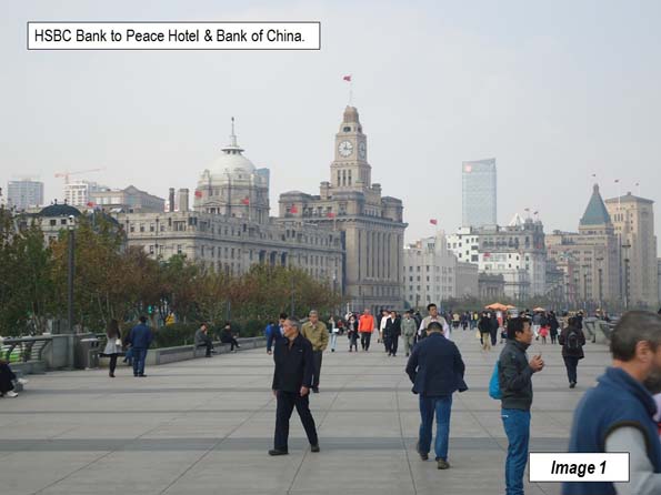
    The Hong Kong and Shanghai Banking Corporation (HSBC) Building is the large domed building near the left of the picture. It was constructed in 1923 and served as the local branch of this UK bank until 1955, six years after the establishment of the People’s Republic of China. When the bank left, it ceded title to the Shanghai People’s Government, which used the building as its headquarters for some years. It is now the Shanghai Pudong Development Bank Building.

    The Customs House is just to the north of the Shanghai Pudong Development Bank Building, with the tall clock tower was opened in 1927.

    The Peace Hotel is farther north, with the green peaked tower. It was originally the Sassoon Hotel and was the north building of the hotel complex. It is now the Fairmont Peace Hotel. Across the street, is the south building of the Peace Hotel, now called the Swatch Art Peace Hotel.

    The Bank of China Building is just to the north of the Peace Hotel. Construction began on the building in the mid-1930s and it was opened after the start of World War II, in 1942.

    The illustrations start at the south end of the Bund, just north of the Pudong Ferry Terminal

    Image 2: Asia Building

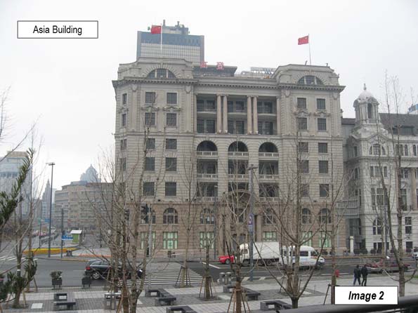
    Image 3: Shanghai Club

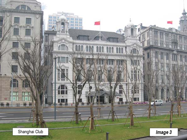
    Image 4: Union & Nish in Navigation Buildings

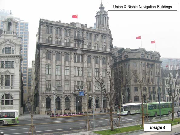
    Image 5: Nishin Navigation & China Merchants Bank Buildings

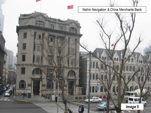
    Image 6: Great Northern Telegraph to HSBC Building

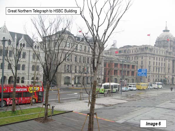
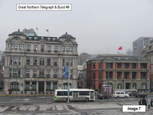
    Image 7: Great Northern Telegraph & Bund #6

    Between Bund #6 and the Hong Kong & Shanghai Bank Buildings, Fuzhou Road reaches Zhongshan Road. Fuzhou Road has been known for its bookstores, though there have been fewer in recent years.

    Image 8: Original Hong Kong & Shanghai Bank (HSBC) Building, now Shanghai Pudong Development Bank.

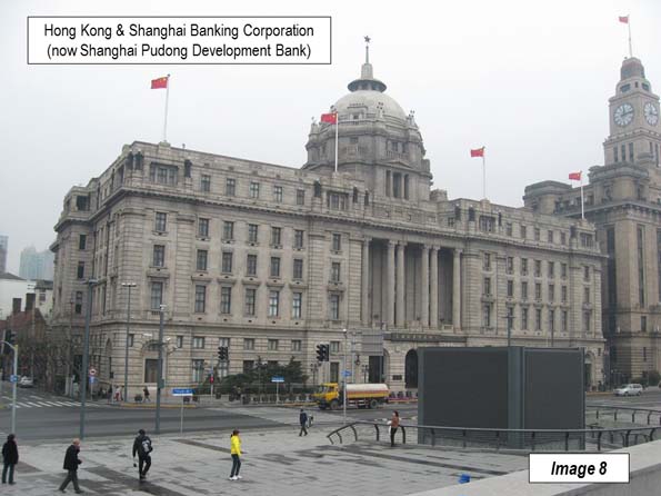
    Image 9: HSBC Bank & Customs House Buildings

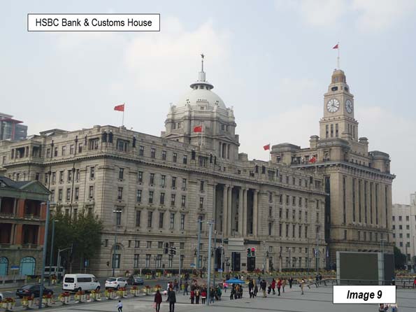
    Image 10: Customs House and buildings to the south

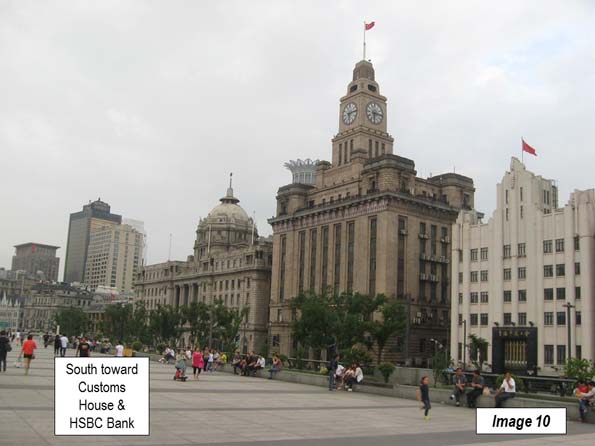
    Image 11: Customs House

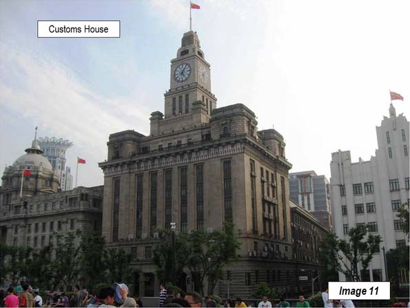
    Image 12: Bank of Shanghai & Russo-Chinese Bank

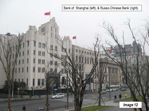
    Image 13: Russo-Chinese Bank, Bank of Taiwan (original name, Taiwan was occupied by Japan when built) and the North China Daily News buildings. The North China Daily News was the leading English newspaper of China until it closed at the beginning of World War II.

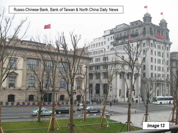
    Image 14: Bank of Taiwan, North China Daily News & Chartered Bank

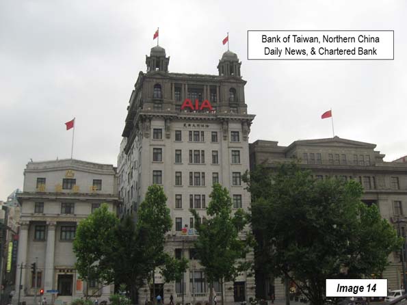
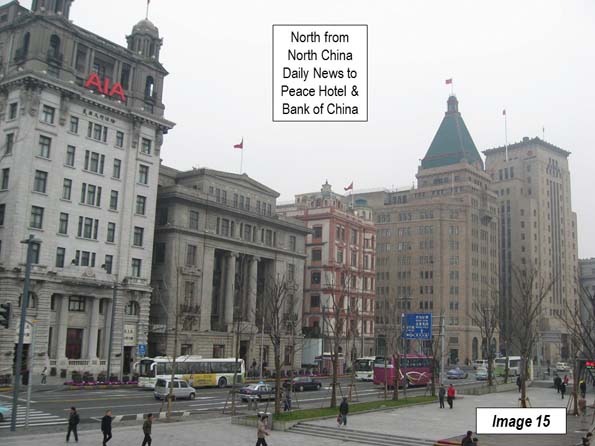
    Image 15: North China Daily News Peace Hotel South Building, Peace Hotel (North) and Bank of China buildings

    The Peace Hotel north and south buildings are across Nanjing Road opposite one another. Nanjing Road is an important shopping street, and a few more blocks inland becomes a pedestrian mall. It is also famous for offers from local students to join them in tea drinking ceremonies or at art exhibitions at which they claim to have work on display. This can be a costly experience and is not recommended.

    Image 16: Peace Hotel (North) and Bank of China

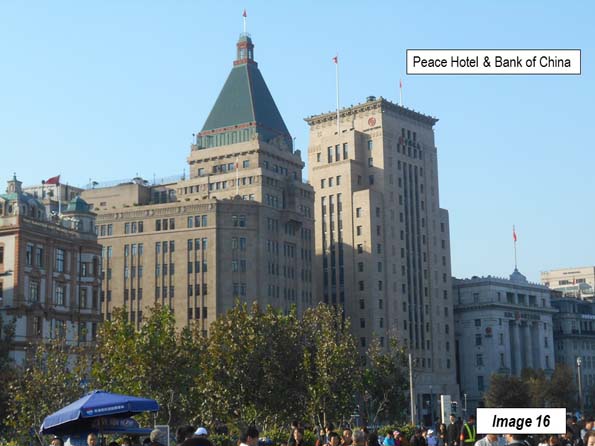
    Image 17: Peace Hotel (North) and Bank of China

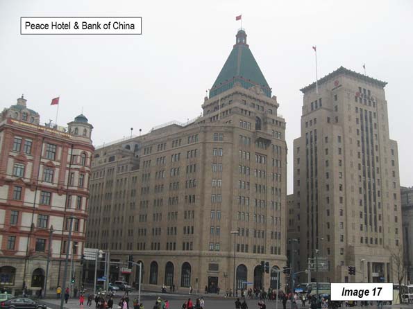
    Image 18: South from Peace Hotel (North) to North China Daily News

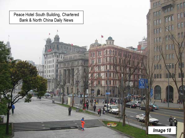
    Image 19: Yokohama Specie Bank and Yangtze Insurance buildings

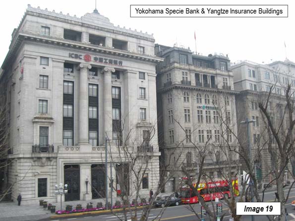
    Image 20: Jardine Matheson, Yangtze Insurance, Yokohama Specie Bank and Peace Hotel (north and south buildings). Jardine Matheson was an early trading company that got its start in Guanghou (Canton) and Hong Kong.

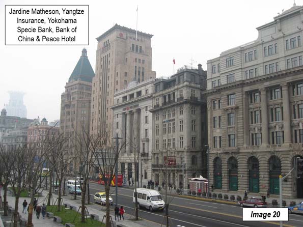
    Image 21: Glen Steamship Lines and Bank of Indochina

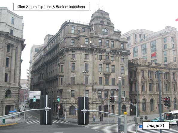
    Image 22: North end of the historic bund buildings on Zhongshan Road (Glen Steamship Lines and Bank of Indochina).

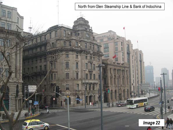
    Image 23: Waibaidu Bridge over Suzhou Creek, Broadway Mansions and Russian Consulate

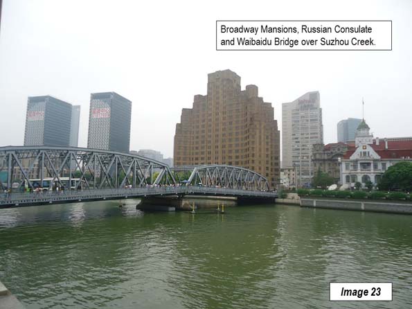
    Image 24: Central Bund, including HSBC, Customs House and North China Daily News buildings from the World Finance Centre. The Shanghai World Finance Center has an opening at the top and locals refer to it as the “bottle opener” for its resemblance (Image 33).

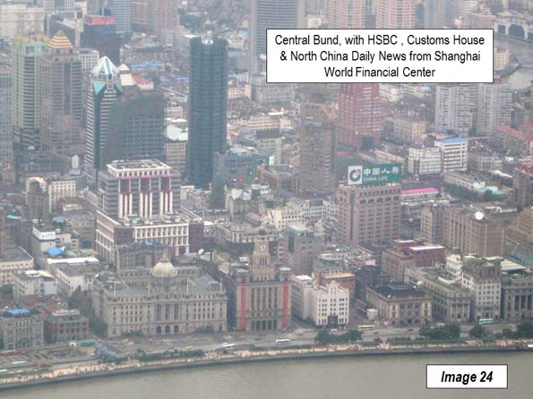
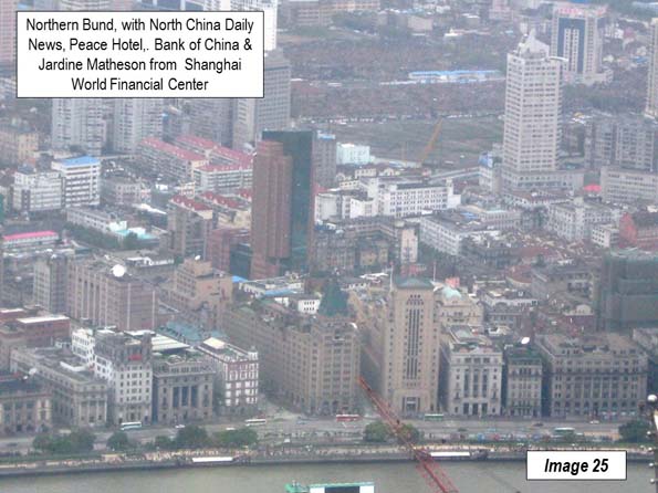
    Image 25: Northern Bund, including North China Daily News, Peace Hotel, Bank of China and Jardine Matheson Buildings from the Shanghai World Financial Tower.

    Images 26 to 28: Promenade views

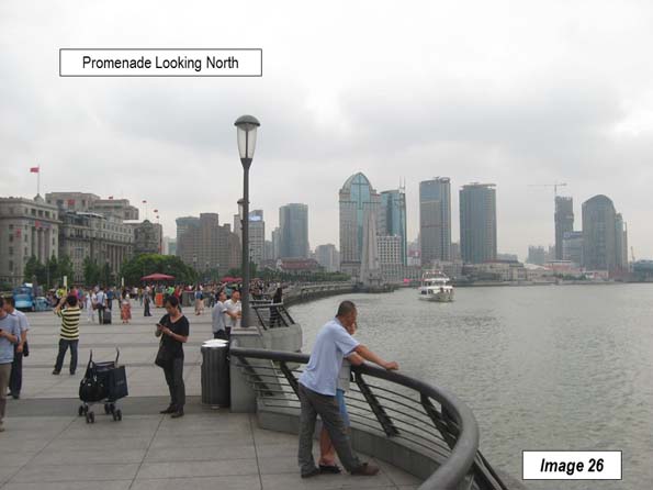
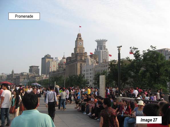
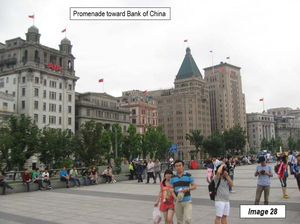
    Image 29: View of Pudong’s Lujiazui business district from the Bund promenade (across the Huang Pu). The Pearl of the Orient Tower is to the left. The tallest building, on the right, is the Shanghai Tower, second tallest building in the world (127 stories).

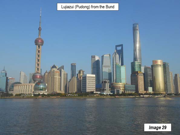
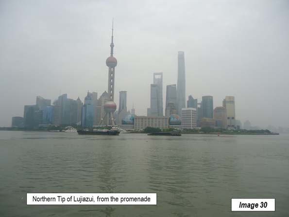
    Image 30: Northern tip of Lujiazui business district from the promenade

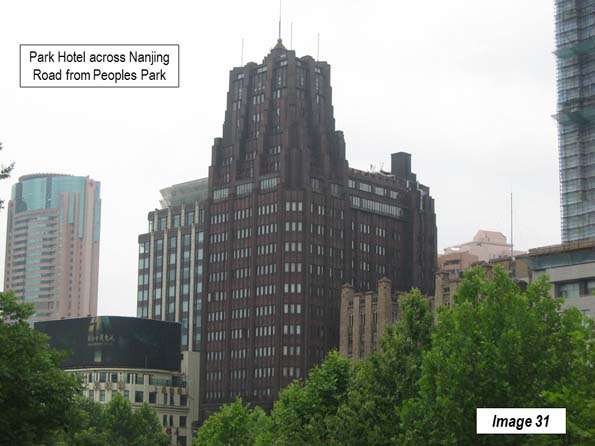
    There are a number of additional Western-style buildings that were a part of the International Settlement in Puxi. Many are on the East – West streets leading from Zhongshan Road as well as on some North – South streets, such as Sichuan Middle Road. Some buildings of the same era are located on Nanjing Road. The Park Hotel, located across the street from People’s Park was the tallest building in Asia when it was built in 1934 (Image 31), and may be the best known local hotel, along with the Peace Hotel, on the Bund.

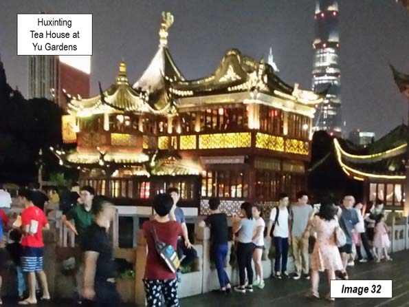
    The Bund is close to other interesting tourist areas. The Yu Garden dates to the 16th century and is the very architectural conception of China for some tourists. As Chinese as is its appearance, not much of Chinese cities looks like this. Yu Garden now hosts extensive shopping, as well as the Huxinting Teahouse (Image 32, at night).

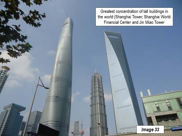
    The Bund sightseeing tunnel provides a short rail service from East Beijing Road (across the street from the Bank of China) under the Huang Pu to Lujiazui, near the Pearl of the Orient Tower. From there overhead walkways provide access to Lujiazui skyscrapers, include the three tallest (Image 33), which are virtually across the street from one another. These include the Shanghai Tower (second tallest in the world), the Shanghai World Financial Center and the shortest, the Jin Miao Tower, which is taller than the Empire State Building in New York and nearly as tall as the Willis Tower (former Sears Tower), in Chicago, the tallest in the world for a quarter of a century.

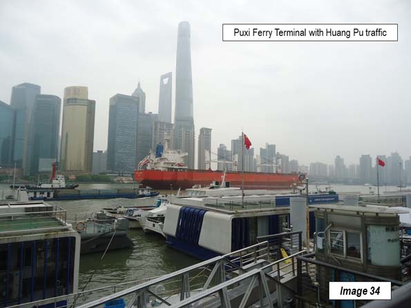
    From here, it is a short walk to the ferry terminal for a short right to the south end of the Bund (Image 34), completing the circle tour that began with Image 2.

    Finally, the Bund promenade is also a very well designed urban space that has become one of Shanghai’s most important public meeting spaces. It is well appointed with places to sit, relax or read a book. Like Le Jardine du Luxembourg in Paris and New York’s Central Park, there are few places to better spend a Saturday afternoon.

    Photograph at Top: Central Bund (Hong Kong & Shanghai Bank and Customs House), by author

    Wendell Cox is principal of Demographia, an international public policy and demographics firm. He is a Senior Fellow of the Center for Opportunity Urbanism (US), Senior Fellow for Housing Affordability and Municipal Policy for the Frontier Centre for Public Policy (Canada), and a member of the Board of Advisors of the Center for Demographics and Policy at Chapman University (California). He is co-author of the "Demographia International Housing Affordability Survey" and author of "Demographia World Urban Areas" and "War on the Dream: How Anti-Sprawl Policy Threatens the Quality of Life." He was appointed to three terms on the Los Angeles County Transportation Commission, where he served with the leading city and county leadership as the only non-elected member. He served as a visiting professor at the Conservatoire National des Arts et Metiers, a national university in Paris.

  • Suburban. Comma. Transit.

    I explored the Orange Line Bus Rapid Transit (BRT) system that runs for eighteen miles across the San Fernando Valley in Los Angeles. The Valley is a profoundly suburban city-within-a-city and home to 1.8 million people spread out over 260 square miles. Attempts to upgrade public transit by the central authorities in LA proper have been fought tooth and nail by folks in the Valley and illustrate why transit just doesn’t work when the local culture doesn’t want it. I’m not sure why LA keeps pushing on this particular string.

    Screen Shot 2016-09-04 at 7.29.48 AM

    screen-shot-2016-09-06-at-1-33-01-pm

    screen-shot-2016-09-06-at-1-37-08-pm

    Transit works best when one compact highly productive walkable neighborhood is connected to another compact highly productive walkable neighborhood. Manhattan or Hong Kong isn’t required. A plain vanilla Main Street with two and three story buildings works just fine.

    Suburbia is the exact opposite. Everything is spread out and oriented around private space, leisure, and consumption. Public space is an afterthought and any hint of density is anathema. Transit is believed to attract “the wrong element.” If this is the kind of world these folks want to inhabit… I say walk away and let them all enjoy the Jiffy Lubes and drive-thru burger joints without transit.

    Screen Shot 2016-09-04 at 7.44.46 AM

    Screen Shot 2016-09-04 at 7.45.15 AM

    Screen Shot 2016-09-04 at 7.29.12 AM

    Screen Shot 2016-09-04 at 8.36.14 AM

    This is the standard suburban environment with its sad begrudging crumbs of half assed bus service. It’s a monumental waste of scarce public funds to attempt to operate public transit here. The land use pattern and culture are in direct conflict with efficient cost-effective transit. And it’s punishing for the people who have no choice but to walk or take the bus: the young, the elderly, the infirm, and the poor.

    Screen Shot 2016-09-04 at 8.35.25 AM

    Screen Shot 2016-09-04 at 8.36.39 AM

    Screen Shot 2016-09-04 at 8.37.30 AM

    Screen Shot 2016-09-04 at 8.35.04 AM

    Screen Shot 2016-09-05 at 3.14.34 AM

    Screen Shot 2016-09-05 at 3.13.22 AM

    Here’s how suburban communities typically deal with transit. To the extent that it’s tolerated at all the transit station is hidden away behind a row of self storage facilities and plumbing supply warehouses. The entrance is treated as if it were an office park. There’s an enormous amount of surface parking. The assumption is that people will drive to the bus or train station since transit is a bridge between the comforts of the private automobile and the necessary evil of commuting to a more congested urban destination.

    Screen Shot 2016-09-04 at 8.32.46 AM

    Screen Shot 2016-09-04 at 8.32.12 AM

    Screen Shot 2016-09-05 at 3.14.07 AM

    Screen Shot 2016-09-04 at 8.31.57 AM

    Screen Shot 2016-09-04 at 8.33.55 AM

    The Park and Ride model of transit like this Metro stop in Chatsworth (the terminus of the Orange Line) is moderately acceptable to middle class suburbanites so long as the station is properly landscaped. Absolutely nothing can be built anywhere near the station. Loitering must be prevented at all costs. Theoretically it’s possible to walk to and from the station, but the location and design of the place ensure it isn’t a common practice.

    Screen Shot 2016-09-05 at 4.07.31 AM

    Screen Shot 2016-09-05 at 4.06.35 AM

    Screen Shot 2016-09-04 at 9.04.15 AM

    Screen Shot 2016-09-04 at 9.03.57 AM

    Screen Shot 2016-09-04 at 9.04.53 AM

    I followed the entire route of the Orange Line and found the stations themselves are well designed, convenient, and efficient. The fully segregated busway disguised in a tunnel of greenery mean buses are never stuck in the same traffic that afflicts cars and trucks. The buses come frequently and predictably and travel is comfortable and fast. BRT simulates the benefits of a light rail system, but at a tenth the cost.

    Screen Shot 2016-09-04 at 9.06.44 AM

    Screen Shot 2016-09-04 at 11.53.30 PM

    Screen Shot 2016-09-04 at 9.05.59 AM

    Screen Shot 2016-09-04 at 9.06.25 AM

    Screen Shot 2016-09-04 at 9.07.05 AM

    But each station was built in a spot that makes it unlikely that transit will live up to its full potential. This is the De Soto stop. The buses do a great job of getting passengers from one isolated station to another. This isn’t an accident. It’s the only set of arrangements the locals would tolerate – and the locals have a lot of lawyers. Transit is associated with the lower class and home owners here want no part of it. So they litigated for years until the proposed rail line was beaten back to a bus route and some decorative shrubbery that didn’t go anywhere too offensive.

    Screen Shot 2016-09-05 at 12.37.57 AM

    screen-shot-2016-09-06-at-9-41-43-am

    screen-shot-2016-09-06-at-9-40-09-am

    screen-shot-2016-09-06-at-9-41-24-am

    screen-shot-2016-09-06-at-9-40-35-am

    screen-shot-2016-09-06-at-9-46-41-am

    Here’s the Balboa station. Abundant surface parking, plenty of landscaped strips, and a location that doesn’t infringe on nearby private property lets people drive to the bus. Unfortunately the effectiveness of good transit is negated by the barren surroundings. If you had access to a car and could drive to the bus… you wouldn’t really need the bus.

    Screen Shot 2016-09-04 at 11.57.48 PM

    Screen Shot 2016-09-04 at 11.54.47 PM

    Screen Shot 2016-09-05 at 12.09.34 AM

    Screen Shot 2016-09-04 at 11.51.50 PM

    Screen Shot 2016-09-04 at 11.52.09 PM

    Here’s the Sepulveda station. Notice how the pattern repeats. In the Valley it’s now possible to take a highly effective bus trip from the Costco parking lot in Van Nuys to a strip mall a dozen miles away in Canoga Park. That’s progress of a sort since the BRT is so much better than traditional suburban bus service. But the public investment in infrastructure isn’t being complimented by the required private investment near any of the stations. That’s because the culture rejects the kind of infill development that would make the stations economically meaningful.

    Screen Shot 2016-09-04 at 11.55.42 PM

    Screen Shot 2016-09-04 at 11.50.02 PM

    Screen Shot 2016-09-04 at 7.25.03 AM

    Screen Shot 2016-09-04 at 7.31.10 AM

    Screen Shot 2016-09-04 at 7.23.44 AM

    Screen Shot 2016-09-04 at 7.24.28 AM

    Bicycle and pedestrian paths parallel the BRT busway along many miles of the system. This allows people to get from Point A to Point B in a way that doesn’t rile up the locals quite as much as the proposed light rail did. Fenced in landscaped bike paths follow the suburban “Sunday in the park” model of leisure that’s at least borderline socially acceptable in the Valley. The fact that low income people also use the paths to peddle to work is an unfortunate and much lamented side effect. I noticed more than a few Spandexed guys on $4,000 bikes yelling at slow moving folks to get out of the way.

    screen-shot-2016-09-06-at-10-40-38-am

    The eighteen miles of Bus Rapid Transit in the Valley cost $324 million dollars to construct. That’s $18 million per mile. Compare that to the recent $1.1 billion road improvement project on a ten mile stretch of freeway in the Valley. The freeway was already ten lanes wide so adding slightly better on and off ramps and tweaking the car pool lanes did exactly nothing to relieve traffic congestion. That’s $110 million dollars per mile. The same people who lament the waste of taxpayer money on transit think the city should be spending more to upgrade the roads.

    Over the years community groups and their elected representatives in the Valley have created legislation that forbids the construction of light rail or the use of sales tax revenue to fund a subway. Other local groups created rules that mandated a fully underground subway system because they objected to surface or elevated rail lines in their neighborhoods. And the ubiquitous anti-infill and anti-density brigades continue as always.

    Personally, I don’t see the point of fighting locals who don’t value transit. I say give this part of the city no transit at all. But also require the locals to fund their own road projects from their own immediate tax base as well. Actually, I would love to see things taken a step farther. Cut the Valley loose from the City of Los Angeles altogether as so many folks in the Valley have attempted to do for decades. Let the Valley keep its own tax revenue and pay for its own services and infrastructure as an independent city. And let Los Angeles be free to focus on projects that actually make sense in the coastal communities that actively want transit and more intensive development. If that means the region is less integrated as a result… I don’t see how things could be worse.

    John Sanphillippo lives in San Francisco and blogs about urbanism, adaptation, and resilience at granolashotgun.com. He’s a member of the Congress for New Urbanism, films videos for faircompanies.com, and is a regular contributor to Strongtowns.org. He earns his living by buying, renovating, and renting undervalued properties in places that have good long term prospects. He is a graduate of Rutgers University.

  • Corporate Mustard Showroom Helps Explain New York’s Retail Rent Crisis

    The story of skyrocketing rents has two components: residential and commercial.

    My New York neighborhood, the Upper West Side, features fairly stable residential rents, but commercial rents seem to have been soaring. This has caused the familiar angst over the loss of neighborhood businesses to the ubiquitous bank branches and drug stores.

    But today even chains are getting priced out. The quintessential marker of gentrification, Starbucks, was recently forced to relocate in my neighborhood. They vacated their stores at 67th and Columbus when the landlord raised their rent to $140,550/month.

    You’ve got to sell a lot of grande’s to cover that kind of rent check. How many businesses can realistically survive at this location? (Maybe none – it’s still vacant).

    A block up the street, another store helps illustrate the forces sending retail rents through the roof. It’s the Maille “mustard boutique” at 68th and Columbus pictured above.

    Maille is a supermarket brand of dijon mustard. It’s a product of Unilever, the Anglo-Dutch food and consumer products giant. You may not know Unilever, but you know their brands, including Hellman’s, Dove, Lipton, and even Ben and Jerry’s.

    This particular location provides mustard tastings, and sells dijon in a variety of flavors not typically available. I believe they also have some vinegars. I was once needed some dijon and purchased a jar of their regular flavor for $7 – which is $3 more it sells for at the grocery store a few blocks away.  They apparently charge as much as $99 for a jar of black truffle mustard.

    I don’t know what their monthly rent is. It’s a smaller, mid-block store than the former Starbucks location. Based on square footage equivalents, the rent would be somewhere around $30,000 a month.

    Can you really sell enough mustard to cover that kind of rent (to say nothing of the “mustard sommelier” and other employees they have on staff and all the other costs of operations)? I see people in the store, but it’s never crowded. And it’s rare to see someone walking out with a shopping bag.

    It strikes me as dubious that this store could even break even, much less turn a profit that would earn the required return on invested capital.

    But ultimately it doesn’t matter if this store makes money or not. The rent isn’t even a rounding error to Unilever and can easily be justified as a marketing expense.

    If there’s one thing it’s not hard to find in this world, it’s gourmet mustard. This neighborhood needs a corporate mustard showroom like it needs a hole in the head.

    But we have one anyway. And there’s actually a second location in the Flatiron. These are the only Maille stores in the US, save for what appears to be a popup going into a Connecticut mall.

    You can tell a lot of amazing “only in New York” stories. But this is an example of a bad one. These showrooms may be exclusive to the city, but they put upward pressure on retail rents and make it harder for actual neighborhood serving businesses to make it. (This location was closed over the summer for a sidewalk replacement project and I was hopeful it wouldn’t reopen – alas, it was to be denied).

    Multiply two Maille mustard showrooms by all the other major corporations who use NYC as a branding platform, and it’s easy to get a sense as to why retail rents are so high in Manhattan.

    Aaron M. Renn is a senior fellow at the Manhattan Institute, a contributing editor of City Journal, and an economic development columnist for Governing magazine. He focuses on ways to help America’s cities thrive in an ever more complex, competitive, globalized, and diverse twenty-first century. During Renn’s 15-year career in management and technology consulting, he was a partner at Accenture and held several technology strategy roles and directed multimillion-dollar global technology implementations. He has contributed to The Guardian, Forbes.com, and numerous other publications. Renn holds a B.S. from Indiana University, where he coauthored an early social-networking platform in 1991.

    Photo: Maille mustard “boutique” on Columbus Ave at 68th St.

  • Can California Transition to Next Tech Wave?

    The consumer technology boom, largely responsible for a resurgence in California’s economy after the tech wreck of 2001, seems to be coming to an end. The signs are widespread: slowing employment, layoffs from bell-weather social media companies, the almost embarrassing difficulty of finding buyers for Twitter, the absorption of Yahoo by Verizon and the acquisition by Microsoft of LinkedIn.

    This is not to minimize the great things which have been accomplished over 15 years of massive investment in these technologies. Mark Zuckerberg founded Facebook in 2004, and is now worth some $55 billion, up $15 billion from last year. In 2015, more than 1 billion people globally used Facebook applications every single day. The “app economy” created by Steve Jobs and Apple is equally impressive. What would we have done with our free time if it were not for Farmville, Angry Birds and Pokemon Go?

    The tech boom has changed the face of wealth in America. Tech oligarchs, mostly clustered in the Bay Area, which dominates some 40 percent of employment in search and web publishing, now account for one quarter of the wealth of the Forbes 400 richest Americans. This tilting of wealth is not going away, and may shape the business world for a generation.

    Concentration and contraction

    Overall though, the economic impact of these technologies has been limited. Google’s Alphabet Inc. and Facebook Inc. together employ fewer than 75,000 people, one-third fewer than Microsoft, worth only a fraction its value. Snapchat, the star of Silicon Beach, employs several hundred people, hardly enough to reverse a long-term decline in Southern California tech employment.

    More troubling still are changes in the Bay Area tech culture. In its 1980s heyday, Silicon Valley was a Wild West of start-ups, new companies and ideas, and lots of jobs. Today, it resembles increasingly the cozy and fundamentally uncompetitive world of Detroit’s Big Three — Ford, Chrysler and General Motors. The Valley is increasingly dominated by a handful of companies — Google, Facebook and Apple — while conditions for startups, even well-funded ones, have deteriorated markedly.

    Read the entire piece at The Orange County Register.

    Joel Kotkin is executive editor of NewGeography.com. He is the Roger Hobbs Distinguished Fellow in Urban Studies at Chapman University and executive director of the Houston-based Center for Opportunity Urbanism. His newest book, The Human City: Urbanism for the rest of us, will be published in April by Agate. He is also author of The New Class ConflictThe City: A Global History, and The Next Hundred Million: America in 2050. He lives in Orange County, CA.

    Marshall Toplansky is Senior Advisor to Chapman University in the area of Data & Analytics, as well as adjunct faculty member at the Argyros School of Business and Economics. Formerly Managing Director of KPMG’s national center of excellence in Data & Analytics, Marshall co-founded big data company Wise Window, a pioneer in analyzing social media, blogs and news stories to track and predict business and political trends. Marshall is Chairman of the Cicero Institute, a strategy and research institution in Salt Lake City, Utah. He is past Managing Director of the Harvard Business School Association of Orange County, and was elected to the Computing Industry Hall of Fame for his role in creating the industry’s largest technical service certification program, A+, which has certified more than 3 million computer technicians worldwide.

  • Today’s Orange County: Not Right Wing—and Kinda Hip

    What comes to mind when you think about Orange County? Probably, images of lascivious housewives and blonde surfers. And certainly, at least if you know your political history, crazed right-wing activists, riding around with anti-UN slogans on their bumpers in this county that served as a crucial birthplace of modern movement conservatism in the 1950s.

    Yet today, Orange County—or the OC, as locals call it—is becoming a very different place. Today close to half the population of this 3-million person region south of Los Angeles are minorities, primarily Latino and Asian, and the county’s future belongs largely to them.

    These days you color the OC both ethnically diverse and politically purplish. The Republican share of the electorate has dropped from 55 percent in 1990 to under 40 percent today. Two of the seven people who represent the area in Congress are Latino, and a third is of Middle Eastern descent. Four of the 10 people the county sends to Sacramento are minorities, three Asians and one Hispanic. Asians, now 20 percent of the local population, represent the majority on the county Board of Supervisors. In 2012 Mitt Romney took the county with 53 percent of the vote; this year it may be far closer than that.

    The cultural landscape is also changing. What was historically a land of hamburger dives (we still have some) and little Mexican restaurants (we have many) is now home to some of Southern California’s best restaurants—including two on the top 30 list ofLos Angeles Times food critic Jonathan Gold. The OC is also home to one of the country’s leading venues for new plays, South Coast Repertory. Alongside the ubiquitous malls have arisen some of the nation’s most innovative urban environments, some of them revived small town main streets, from Santa Ana’s 4th Street Market to Orange to Laguna Beach and Fullerton.

    When urbanists talk about the future, they usually imagine an environment of dense buildings, connected by train transit and highly centralized workplaces. Yet the bulk of all the nation’s economic and population growth takes place in “post-suburbia,” a term first applied to the OC. Post-suburbia, noted two urban scholars in 1991, reflects a “decentralized, multi-centered area” that puts “into question the mainstream urbanist’s concept of central-city dominance.”

    This new geography of urbanity—far more than the much-discussed recovery of the urban core—dominates our metropolitan life; since 2000 over 80 percent of all metropolitan area jobs and population have remained outside the urban core. Post-suburbia predominates among our most demographically and economically vital regions, including STEM-intensive regions such as Silicon Valley, the northern reaches of Dallas, the western suburbs of Houston, Johnson County west of Kansas City or virtually anything around Raleigh or Austin. Orange County’s STEM sector (PDF) has expanded at twice the rate of L.A. County, despite all the considerable hype about the emergence of “Silicon Beach.”

    Post-suburbia was not designed to be a traditional commuter suburb, where people pile onto trains or the highways to get “downtown.” The vast majority of OC people work in the plethora of county worksites, and many others, particularly from the Inland Empire to the east, drive into the area for work.

    What places like the OC sell is both work and quality of life. The area ranks 10th out of 3,111 counties in the U.S. for natural amenities, and even outpaces Los Angeles among cities for best recreation. The roads are less congested, and there’s more open space. Urban Los Angeles has 9.4 acres of parks and recreation areas per 1,000 residents; Irvine has 37 acres per 1,000 residents, meaning that over 20 percent of the city’s land is dedicated to parks, five times the national average. No wonder the Irvine city motto is “Another Day in Paradise.”

    All changes are not for the better, of course, and one of the chief problems in today’s OC is the cost of housing. Irvine is a city of 236,000 people that was once a classic Anglo suburb and is now 40 percent Asian and less than half white. Housing, once distinctly middle class, now averages near $800,000, in large part due to purchases by Chinese investors. According to the real-estate information firm DataQuick, the 25 most common last names of homebuyers last year were Chen, Lee, and Wang.

    The landscape has also changed, with massive rows of multi-family houses crowding the wide boulevards of the city, clogging traffic and making “paradise” a little less bucolic. Since 2000, Orange County’s prices have increased 3.5 times that of incomes, one of the highest rates of increase in the country. The middle class who came to experience a Disneyland urban existence now finds the county largely beyond their means.

    These price increases have benefited many older property owners, particularly along the strip near the Pacific Ocean—now among the most expensive places to live in the country—but have sent rents soaring as well. Santa Ana, right next door to Irvine, is home now to much of the county’sgrowing homeless population, now estimated at 15,000, in large part reflecting rents increasingly out of reach to the working poor. If one full-time worker rents a two-bedroom apartment in Orange County they can expect to spend over 40 percent of their income (PDF) on rent.

    High prices are making the OC increasingly unaffordable for young families. Despite the assertions by density advocates, most millennials remain deeply interested in home ownership and generally move to places they can afford a house, which is usually somewhere else. This is one reason why Orange County, once an epicenter of youth culture, is going grey—and quickly.

    Orange County’s old folks feel little reason to move, short of being carried out feet first. The OC’s perfect weather, coupled with Proposition 13 protections, keeps seniors in their homes long after their offspring have left. With grey ponytails common even among surfers, the OC by 2040 is on track to be the oldest major county in California.

    The big hope may be the aging of millennials who by 2018 will on average be over 30. With safe cities and exceptional schools, the OC is a great place for “grownup millennials” looking to raise a family. Kina De Santis, CMO of the Orange County-based tech startup Motormood, calls it “very family oriented,” and Lee Decker, CMO at IGNITE Agency praises it for having the right environment for those with families who still want to focus on their startups, explaining, “As I prepare to get married to my kick ass and ridiculously supportive fiancé, I’m deciding to firmly root myself here in OC.” 

    In a famous scene from the play Hamilton, the future treasury secretary and his friend, Marquis de Lafayette, celebrate America’s revolutionary victory with the words—“immigrants, we get the job done.” As the OC evolves in the coming decades, the fast-growing foreign born population, and their offspring, will play the leading roles.

    In 1970, 80 percent of OC residents were non-Hispanic white. Many feared new immigrants, with the OC Grand Jury—a body of 19 to 23 members impaneled for one year to investigate and report on both criminal and civil matters within the county—in 1993 calling for a three-year ban on all immigration. Since 2000, the area’s Latino growth rate has been roughly 50 percent greater than Los Angeles’s. By 2014, the non-Hispanic white population dropped to 43 percent of the population, while the Hispanic share rose to 35.3 percent.

    The growth of the Asian population has been, if anything, more dramatic. One critical turning point was the arrival of the Vietnamese after the 1975 fall of Saigon, which turned Westminster from a sleepy town to one of the largest settlements of Vietnamese outside the mother country. More recently, Koreans and ethnic Chinese have arrived in significant numbers.

    Since 2000, Orange County’s Asian population has been growing at roughly 3 percent annually, roughly 50 percent faster than Los Angeles County. The OC’s rate is roughly equal to that of such Asian migration centers as Santa Clara, San Francisco, and New York. Overall, Orange County is the nation’s fourth most heavily Asian county over 1 million, at roughly 20 percent.

    Although they differ in appearance from the old OC denizens, these new OC residents are attracted by many of the same things that brought earlier immigrants to the area—single family homes, parks, and good public schools. They have created a dazzling series of ethnic “villages” from the heavilyVietnamese band from Westminster to Garden Grove, to the expanding “Little Korea” in the same area, the “Little Arabia in Anaheim and the El Centro Cultural de Mexico, located in Santa Ana.

    These newcomers and their kids are reshaping the OC’s culture, which plays a huge part in the area’s economy, employing well over 50,000 people; overall, the county lags only New York and Los Angeles in terms of the role of creative industries. In the past much of this was tied to the surfer culture, most notably serving as the fashion capital of the surf wear world—known to some Boomer adepts as “Velcro valley,” built around surf wear icons Hurley, Quicksilver, and O’Neill. The creative sector is adding jobs across a range of other industries such as architecture and interior design. Orange County is increasingly proving itself capable to draw the talent and support the lifestyle to compete with other creative powerhouses such as Los Angeles and New York.

    Immigrants provide much of the impetus. Much of the best food in Orange County is produced by newcomers and their children. The immigrant reshaping of the OC also is reflected in the bustling ethnic shopping malls that dot the county, packed with shops selling groceries, clothing, travel packages, and videos to the increasingly diverse population. Even more important is the growing cross-fertilization of ethnic styles and tastes. Urban amenities such as locally owned restaurants, bars, and retail shops at Huntington Beach’s Pacific City, keep things interesting as people are increasingly looking to spend their money on regionally tuned experiences (PDF), rather than typical suburban chains.

    Perhaps the most influential figure here is Shaheen Sadeghi, a Persian-American and former CEO of the surf wear line Quicksilver. Sadeghi’s company has taken a dozen sites, many of them deserted industrial and warehouse spaces, and converted them into exciting urban spaces. Perhaps his most impressive is the Packing House in Anaheim, a gigantic food court located in a former fruit-packing facility, which teems with ethnic food vendors.

    Critically, Sadeghi’s vision goes well beyond the usual urbanist dreamscape of a culture dominated by hip singles and childless couples. He wants to appeal to families, just in an updated way. “The international community tends to be more family oriented,” he notes, “on the weekend at the Packing House you’ll see a family from Asia putting all the tables and chairs together.”

    Building this new vision for OC will not be easy, he realizes, given the regulatory vise exercised by California regulators on small business. Yet he sees the area’s decentralization—epitomized by the county’s 34 separate cities—as providing consumers with greater diversity and choice. “Each city has its own identity, brand, and culture,” he suggests. “It’s like there’s more cookies in the cookie jar.”

    Sadeghi is bringing the old OC model to the future, proving that post-suburban “sprawl” can coexist with diversity and culture. Like the visionaries who created Disneyland, Irvine and other earlier iconic expressions of the county’s past, innovators like Sadeghi are willing to buck models, urban or otherwise, in pursuit of a unique sensibility. The OC should not aspire to become another Brooklyn, he suggests, but exploit all its natural advantages, as well as its efflorescent diversity to reinvent itself. “After all,” he says with an inner reassurance those of us who live here tend to have, “we still have a couple of things no one else has—ocean and good weather. And they aren’t going away.”

    Joel Kotkin is executive editor of NewGeography.com. He is the Roger Hobbs Distinguished Fellow in Urban Studies at Chapman University and executive director of the Houston-based Center for Opportunity Urbanism. His newest book, The Human City: Urbanism for the rest of us, will be published in April by Agate. He is also author of The New Class ConflictThe City: A Global History, and The Next Hundred Million: America in 2050. He lives in Orange County, CA.

  • Two Cheers for NIMBYism

    Politicians, housing advocates, planners and developers often blame the NIMBY — “not in my backyard” — lobby for the state’s housing crisis. And it’s true that some locals overreact with unrealistic growth limits that cut off any new housing supply and have blocked reasonable ways to boost supply.

    But the biggest impediment to solving our housing crisis lies not principally with neighbors protecting their local neighborhoods, but rather with central governments determined to limit, and make ever more expensive, single-family housing. Economist Issi Romem notes that, based on the past, “failing to expand cities [to allow sprawl] will come at a cost” to the housing market.

    A density-only policy tends to raise prices, turning California into the burial ground for the aspirations of the young and minorities. This reflects an utter disregard for most people’s preferences for a single-family home — including millennials, particularly as they enter their 30s.

    In California, these policies are pushed as penance for climate change, although analyses from McKinsey & Company and others suggest that the connection between “sprawl” and global warming is dubious at best, and could be could be mitigated much more cost-effectively through increased work at home, tough fuel standards and the dispersion of employment.

    Read the entire piece at The Orange County Register.

    Joel Kotkin is executive editor of NewGeography.com. He is the Roger Hobbs Distinguished Fellow in Urban Studies at Chapman University and executive director of the Houston-based Center for Opportunity Urbanism. His newest book, The Human City: Urbanism for the rest of us, will be published in April by Agate. He is also author of The New Class ConflictThe City: A Global History, and The Next Hundred Million: America in 2050. He lives in Orange County, CA.

  • America’s Next Great Metropolis Is Taking Shape In Texas

    If you drive south from Dallas, or west from Houston, a subtle shift takes place. The monotonous, flat prairie that dominates much of Texas gives way to a landscape that rises and ebbs.

    The region around Highway 35 is called the Hill Country, and although it does not seem so curvy to a Californian, it is some of the very nicest country in the state of Texas, attracting a growing coterie of wealthy boomers. It also turns out to be a growth corridor that is expanding more rapidly than any in the nation. The area is home to three of the nation’s 10 fastest-growing counties with populations over 100,000 since 2010.

    In fact, there is no regional economy that has more momentum than the one that straddles the 74 miles between San Antonio and Austin. Between these two fast-growing urban centers lie a series of rapidly expanding counties and several smaller cities, notably San Marcos, that are attracting residents and creating jobs at remarkable rates.

    Anchoring one end of the region is Austin, which has been the all-around growth champion among America’s larger cities for the better part of a decade. Texas Monthly has dubbed it the “land of the perpetual boom.”

    Austin has been ranked among the top two or three fastest-growing cities for jobs virtually every year since we began compiling our annual jobs rankings. Since 2000, employment in the Austin area has expanded 52.3%, 15 percentage points more than either Dallas-Ft. Worth or Houston.

    Comparisons with the other big metros are almost pathetic. Austin’s job growth has been roughly three times that of New York, more than four times that of San Francisco, five times Los Angeles’ and 10 times that of Chicago. Simply put, Austin is putting the rest of the big metro areas in the shade.

    Nor can Austin be dismissed as a place where low-skilled workers flee, as was said about other former fast-growing stars, notably Las Vegas. Just look at employment in STEM (science-, technology-, engineering- and math-related fields). Since 2001, Austin’s STEM workforce has expanded 35%, compared to 10% for the country as a whole, 26% in San Francisco, a mere 2% in New York and zero in Los Angeles. And contrary to perceptions, the vast majority of this growth has taken place outside the entertainment-oriented core, notes University of Texas professor Ryan Streeter, with nearly half outside the city limits.

    Austin has also been sizzling in the business services arena, the largest high-wage job sector in the country. Since 2001, employment in business services in the Austin area has grown 87%, more than any of the large Texas towns.

    No surprise then that Austin has become a magnet for people. Its population has grown at the fastest rate among U.S. metro areas above a million in the nation since 2000, an amazing 60%. That’s more than twice as fast as Atlanta, three times more than hipster haven Portland, roughly six times San Francisco and San Jose, and more than six times Los Angeles or New York. Much of the growth is coming from migration rather than births, and it boasts the highest rate of net in-migration of all the big Texas cities. The biggest sources of newcomers, according to an analysis of IRS data by the Manhattan Institute’s Aaron Renn, are California, the Northeast and Florida.

    San Antonio: The Emerging Upstart

    During the decades of Texas’ urban boom, San Antonio has been considered a laggard, a somewhat sleepy Latino town with great food and tourist attractions and a slow pace of life. “There has been a long perception of San Antonio as a poor city with a nice river area,” says Rogelio Sáenz, dean of the public policy school at the University of Texas-San Antonio.

    Economic and population data say otherwise. Since 2000, San Antonio has clocked 31.1% job growth, slightly behind Houston, but more than twice that of New York, and almost three times that of San Francisco and Los Angeles.

    And many of the new jobs are not in hospitality, or low-end services, but in the upper echelon of employment. This reflects the area’s strong military connections, which have made it a center forsuch growth industries as aerospace, and cyber-security. Although slightly behind Austin, San Antonio’s STEM job growth since 2001 — 29% — is greater than that of all other Texas cities, as well as San Francisco’s, and three times the national average.

    Similar growth can be seen in such fields as business and professional services, where the San Antonio area has expanded its job base by 44% since 2000. This just about tracks the other Texas cities, and leaves the other traditional business service hotbeds — New York, San Francisco, Chicago and Los Angeles — well behind. The city has also expanded its financial sector; the region ranked seventh in our latest survey of the fastest-growing financial centers. Once again, there is a military connection; much of the area’s financial growth has been based on USAA, which provides financial services to current and former military personnel around the country, and employs 17,000 workers from its headquarters in the city’s burgeoning northwest.

    But perhaps most encouraging has been the massive in-migration into San Antonio. Long seen as a place dominated by people who grew up there, the metro area has become a magnet for new arrivals. Since 2010, its rate of net domestic in-migration trails only Austin among the major Texas cities. Significantly, the area’s educated millennial population growth ranks in the top 10 of America’s big cities, just about even with Austin, and well ahead of such touted “brain centers” as Boston, New York, San Francisco.

    In the process, San Antonio is emerging as an attractive alternative for young professionals and families to an Austin that has become more congested and expensive. The cost of living in San Antonio is significantly lower than the other Texas cities, and less than half that of places like San Francisco and Brooklyn. As the vanguard of millennials moves into the family forming, childbearing and house-buying years in the coming decade, San Antonio, with its increasingly lively music, art and restaurant scence, is likely to grow in attractiveness.

    Greater San Marcos: Whoa Nellie!

    As impressive as San Antonio and Austin’s progress has been, the most dramatic locus for growth in the region is between the two cities. The San Marcos area, which lies at the center of the corridor, has clocked growth that is among the most rapid in the nation by several measures. Looking at population, two of the 10 fastest growing counties in the country since 2010 are located in this corridor — Hays and Comal. Their growth rate, 4% per annum since 2010, exceeds Austin’s 3% and is almost double the growth rate of Dallas-Ft. Worth and Houston.

    As is usual in Texas, and most American cities, urban growth tends to expand outwards, not only for population but also for jobs. Over the past decade, Hays and Comal’s job growth rate has been an astounding 37%, outpacing Austin’s impressive 31% growth, the other Texas cities, and over six times the pace of the country overall.

    Local boosters suggest that this growth will transform the San Marcos area into something like other suburban nerdistans, such as San Jose/Silicon Valley, north Dallas, Orange County and Raleigh-Durham. Certainly some of the same advantages those areas enjoyed are emerging, including the growth of Texas State University at San Marcos (now with over 38,000 students) as a major center of higher education.

    Equally important, note researchers John Beddow and James LeSage, the central location of the San Marcos area allows families to choose from not only local jobs, but those located in both San Antonio and Austin. And to be sure, tech, education, business and professional services are all growing rapidly, but so far much of the development is lower on the food chain, such as food service and wholesale trade. Amazon, for example, just recently opened a sprawling, 855,000-square-foot warehouse in San Marcos, which is slated to employ upwards of 1,000 people.

    Choices To Be Made

    If you were to look for the next great American metropolis, there’s probably no better bet than the emerging San Antonio-Austin corridor. The elements are all there: major universities, including the Austin and San Antonio campuses of the University of Texas, job and population growth, low housing prices and a burgeoning tech community. Perhaps even more important, this part of Texas is only marginally tied to the energy industry, which has become a huge drag on the economy of the state’s largest city, Houston.

    Yet there remain many challenges. One is transportation, particularly around freeway allergic Austin, although San Antonio has an excellent and largely free-flowing system. The Austin bottleneck is particularly troublesome because much of the city’s growth is to the north, which means commuters living in the San Marcos region have to navigate through painfully slow freeways. Another is education, despite the university presence. San Marcos and Austin may be above the national average in terms of the percentage of college-educated residents, but San Antonio and New Braunfels, a large town south of San Marcos, still lag.

    To maintain the area’s natural beauty, steps must be taken to prevent development from overrunning the Hill Country.

    But none of this should stop this region from coalescing into something that represents a Texas version of Silicon Valley — a little less dependent on the highest end of companies, less expensive and more diversified — providing a powerful new entrant among the nerdistans that increasingly dominate our national economy.

    This piece first appeared in Forbes.

    Joel Kotkin is executive editor of NewGeography.com. He is the Roger Hobbs Distinguished Fellow in Urban Studies at Chapman University and executive director of the Houston-based Center for Opportunity Urbanism. His newest book, The Human City: Urbanism for the rest of us, will be published in April by Agate. He is also author of The New Class ConflictThe City: A Global History, and The Next Hundred Million: America in 2050. He lives in Orange County, CA.

  • The Rival Future Visions of Peter Thiel and Scott Adams

    Our mental model of the world shapes our behavior at fundamental levels in ways we often can’t even recognize. I was struck by this when reading two books almost back to back, Scott Adams’ How to Fail at Almost Everything and Still Win Big and Peter Thiel’s Zero to One.

    Both authors lay out a schema for modeling the future and how to behave relative to it, but come to very different conclusions.

    Scott Adams, creator of the Dilbert comic strip, has a simple model: systems over goals. That is, it’s better to have a good system with high odds of success vs. setting a concrete goal and working towards it. In other words, get your lifestyle right when it comes to diet and exercise, don’t focus on losing X pounds to reach Y weight.

    This strategy implies a single worldview axis: goals-systems, with a preferred end of the axis on which one should align his personal decision making.

    Thiel, founder of PayPal, has a more formal framework, but adopts the same axis of decision making. In his case, he labels it definite-indefinite. He then combines this with an axis of optimist-pessimist to produce the following 2×2 matrix:


    Peter Thiel future model matrix. Image via Will Price’s Zero to One review.

    Both Thiel and Adams are American, so reside in the top half of the chart, so let’s focus there. To Thiel, a goal is a definite view of the future. That is, you have an exact idea of what the future should be, and set about making it happen. A system would be an indefinite future. In this view, we can’t fundamentally control the future, so we put ourselves in the best position to benefit from the chance that comes our way.

    Now these two don’t have perfect alignment. Adams’ systems are in many cases designed to achieve results that could be viewed as a goal (e.g., a ripped physique). As a serial entrepreneur, he’s not afraid of starting companies, but does not put everything at risk while doing so. Most of what Adams would call goals Thiel would still label indefinite because they present incremental improvement vs. revolutionary change (e.g., lose 15 pounds vs. “We chose to go to the moon.”)  But there’s a rough correspondence.

    Adams, as we saw, comes down firmly on the indefinite/systems side of the equation. Thiel says that the would be startup founder should be in the definite/goals quadrant, and believes that part of the reason America has gone off course is that we’ve shifted from a definite to indefinite view of the future.

    In the 1950s, people welcomed big plans and asked whether they would work. Today a grand plan coming from a schoolteacher would be dismissed as crankery, and a long-range vision coming from anyone more powerful would be derided as hubris.

    In addition to his more formal framework for thinking about the future, Thiel also tries to explain why people like Adams have an indefinite view of the future:

    But perhaps you can’t understand Malcolm Gladwell without understanding his historical context as a Boomer (born in 1963). When Baby Boomers grow up and write books to explain why one or another individual is successful, they point to the power of a particular individual’s context as determined by chance. But they miss the even bigger social context for their own preferred explanations: a whole generation learned from childhood to overrate the power of chance and underrate the importance of planning. Gladwell at first appears to be making a contrarian critique of the myth of the self-made businessman, but actually his own account encapsulates the conventional view of a generation.

    Adams is a baby boomer, putting him squarely within this generational psychoanalysis.

    Is one of the two right? I think it’s more complex than that, and in part comes down to what you want, what your temperament is, and what your experiences have been in life.

    Thiel obviously has gargantuan Silicon Valley ambitions and an ego to match. And he’s got over a billion dollars to show for it.

    Adams’ success is much smaller scale – but still well into the millions of dollars, plus a significant amount of fame. He appears to be fully satisfied with his life.

    So at the individual level, you can succeed either way. At a societal level, Thiel may have a point, though Robert Gordon and others posit different explanations for the economic growth slowdown.

    In any case, the key is that how you think about the future, particularly the degree to which you can shape the future, determines a lot about the strategies you are going to use for your life. On the one hand perhaps a concentrated bet and effort to sculpt the future. On the other a more open or diversified strategy to try get the best result in in uncertain future. (I should note that Thiel says this kind of diversification is a myth, saying, “Life is not a portfolio”).

    I also recently read and reviewed Antifragile by Nassim Taleb. While I’m not familiar with his full corpus, his high view of randomness suggests that he’s favors a more Adams-like approach. He advocates that people should adopt what he calls a “barbell” strategy. That is, on one end you try to derisk your core life as much as possible. And on the other you place multiple, small, high risk bets with a chance of a significant payoff. This sounds like a system to me. On the other hand, Taleb also says that entrepreneurs who risk the definite should be treated with honor as heroes, even if they fail.

    In any case, it’s worth thinking about how we view the future. Is it something that’s primarily within our control or something that’s more dominated by outside forces or even chance? How we answer that question will determine a lot about how we go about living our lives.

    Aaron M. Renn is a senior fellow at the Manhattan Institute, a contributing editor of City Journal, and an economic development columnist for Governing magazine. He focuses on ways to help America’s cities thrive in an ever more complex, competitive, globalized, and diverse twenty-first century. During Renn’s 15-year career in management and technology consulting, he was a partner at Accenture and held several technology strategy roles and directed multimillion-dollar global technology implementations. He has contributed to The Guardian, Forbes.com, and numerous other publications. Renn holds a B.S. from Indiana University, where he coauthored an early social-networking platform in 1991.

  • Welcome to Rosemont, IL

    Millions of people pass through O’Hare, settle into the adjacent hotels, go to conferences and meetings in the nearby convention centers, shop in the nearby stores or drink and eat in the nearby bars and restaurants, and believe they’re in Chicago.  But they’re not.  In most cases, they’re in the small village of Rosemont, the tiny town that’s done more than any community I know to capitalize on its location.

    Last week my wife and son flew out of town for a quick vacation on the West Coast.  As for me, duty called and I was unable to join them.  But I did drop them off and pick them up from Chicago’s main international airport, O’Hare.  While I waited for their arrival, I drove around the area surrounding the airport. For reference, here’s Rosemont’s boundaries, courtesy of Google Maps.  Rosemont is the area shaded in faint red (click on the map if you need to make it larger):

    Here’s what many people don’t know.  Yes, O’Hare International Airport is technically within the City of Chicago.  The airport is owned and operated by the City; Chicago Transit Authority (CTA) “L” lines can take you directly from downtown Chicago to the airport within 30-40 minutes.  But the airport is connected to the rest of Chicago by a sliver of property that follows the parcels fronting Foster Avenue for about a half mile, before connecting with the broad tarmac that is the airport.  Immediately east of the airport, where all the highways meet that connect the airport to the region, stands little Rosemont.

    But “little” hardly applies in any sense to Rosemont.  The village is a dizzying mix of hotels, convention centers, restaurants, large and small-scale entertainment venues, tightly packed against the interstates that wind their way through the community.  Those familiar with the area know that the area has almost a Vegas Strip feel to it, with a scale that can overwhelm.  Here’s some screenshots from Google Earth:

    What you see above are hotels, a convention center, office complexes, an outlet mall, and Allstate Arena, a venue for professional and collegiate sports teams.  What have I not included?  Myriad bars and restaurants, a performing arts center, even a field for a professional women’s softball team.  There’s even a casino, but it’s in yet another suburb, Des Plaines, just feet from the Rosemont boundary.  All of this within a 1.8 square mile area that holds only 4,200 residents.

    How did this happen?  Two words, one man — Donald Stephens.

    Airplane construction had taken place on the site that is now O’Hare for many years prior to the airport’s official opening in 1963.  The City of Chicago annexed the property for manufacturing uses in the 1940s, using the Foster Avenue sliver mentioned earlier to reach the site.  Chicago, as well as neighboring suburbs Des Plaines, Park Ridge and Schiller Park, all passed on annexing the land just east of what was a major manufacturing hub.  However, the Interstate Highway Act, which initiated the construction of the Interstate Highway system, was passed in 1956.  That act opened up possibilities for the development of an airport and changed how the empty lands would be viewed.  Donald Stephens, an insurance underwriter, led the effort to incorporate the community that same year.

    Rosemont’s boom as a commercial center paralleled the growth and expansion of O’Hare.  First came the hotels, and then smaller commercial uses like bars and restaurants.  The Donald Stephens Convention Center and Allstate Arena opened in 1975 and 1980, respectively, and throughout much of the ’80s the entertainment district also grew and expanded.  The airport-driven uses continue to gather in the community; the Rosemont Theater for the Performing Arts opened in 1995.  The Fashion Outlet Mall of Chicago opened in 2013.

    This extreme concentration of commercial, recreational and entertainment uses led to a unique development in Rosemont.  In 1995, residents living within the small residential core of the community voted to enclose all portions of residential Rosemont as a gated community.  Rosemont residents may fight major traffic when going to or coming home from work, but they have a sense of security that usually comes with living in upper class enclaves.

    Rosemont’s growth didn’t come without controversy.  Stephens, who was the only mayor of Rosemont from its founding in 1956 until his death in 2007, was often dogged with accusations of associations with Chicago organized crime.  Twice he was brought up on political corruption charges, for tax fraud and bribery, but was acquitted.  After Stephens’ death, his son Bradley assumed the position of mayor.

    Rosemont’s unique location has led to a unique set of statistics about the community. The community’s residents are firmly middle- and working-class: the median household income for residents is about $46,000, just below the metro area’s median of $55,000.  Demographically speaking, the community is about 57% non-Hispanic white and 35% Hispanic/Latino.  Rosemont residents lag behind the metro area in terms of educational attainment by one measure 13.1% of residents over age 25 have a bachelor’s degree or more, compared to 35.3% in the metro area.

    But none of that matters when the community has outsized economic numbers related to its location.  In a region that averages about 1.1 jobs per household, Rosemont has 11.3.  In a region that averages about $14,500 in general merchandise retail sales per capita, Rosemont has over $163,000.  In 2014, Rosemont had an equalized assessed value, or a value for all property in the community, of nearly $260 million.  Schiller Park, just to the south of Rosemont and nearly three times its size in terms of residents, had an equalized assessed value of $290 million.

    So, in many respects Rosemont is less a community than a state-chartered commercial and entertainment district.  Its successes cannot be replicated.  But that doesn’t mean that its successes are enduring.  On my brief visit there, I saw many pedestrians walking across Rosemont from one commercial or entertainment venue to another, in what is a challenging walkable environment.  The network of interstates that meet in the village means that it is an environment for cars, and there’s currently no way around that.  If Rosemont wishes to maintain its position as a commercial and entertainment venue, it may really need to consider improved walkability as a way to reach new and younger demographics travelling through Chicago.

    As for me, I often wonder how the area would look if Chicago had the foresight and vision to annex the property prior to the development of O’Hare,  If it had, the uses may have been quite similar but the look very different.

    Top photo: The Hyatt Regency O’Hare, located in Rosemont, IL.  Source: totsandtravel.com

    Pete Saunders is a Detroit native who has worked as a public and private sector urban planner in the Chicago area for more than twenty years.  He is also the author of “The Corner Side Yard,” an urban planning blog that focuses on the redevelopment and revitalization of Rust Belt cities.

  • A Better Way

    My recent post at Granola Shotgun described how a town in Georgia spent an enormous amount of public money on a new civic center and road expansions, but somehow managed to devalue nearby private property in the process. Here’s an example of a neighborhood in Nashville, Tennessee that took a different approach that cost a lot less and achieved a radically better set of outcomes.


    Screen Shot 2016-08-25 at 6.01.50 PM

    Screen Shot 2016-08-25 at 5.49.18 PM

    The McCabe Park Community Center was designed by a local firm rather than an international starchitect. Municipal funds were recirculated right in town and used to foster native talent and professional employment. And while the facilities are available to everyone in Nashville this center is scaled and programmed primarily to serve the immediate neighborhood.

    Screen Shot 2016-08-25 at 9.25.20 PMGoogle

    Screen Shot 2016-08-25 at 6.41.04 PM

    A conscious decision was made to accommodate pedestrians rather than provide the usual endless automobile infrastructure. There are the required handicap accessible parking spaces close to the entrance at the rear. There are a few dozen off street parking spots along the baseball diamond. But that’s it. It’s absolutely possible to arrive by motor vehicle, but the cars don’t dominate the landscape.

    Screen Shot 2016-08-25 at 11.08.02 PM

    Screen Shot 2016-08-25 at 5.48.42 PM

    Screen Shot 2016-08-25 at 6.01.06 PM

    Bicycle and pedestrian infrastructure make it clear that it’s safe, pleasant, convenient, and dignified to arrive without a car. One of the goals of this community center is to facilitate a more active and healthy lifestyle.

    Screen Shot 2016-08-25 at 11.40.11 PMGoogle from 2009

    Screen Shot 2016-08-26 at 1.07.16 AMGoogle Street View from 2009

    Screen Shot 2016-08-26 at 1.05.07 AMGoogle Street View from 2009

    Screen Shot 2016-08-26 at 1.06.32 AMGoogle Street View form 2009

    Screen Shot 2016-08-26 at 1.48.03 AMGoogle Street View form 2009

    The road out front was a standard suburban affair of wide lanes, fast moving vehicles, no distinction between the road surface and adjacent parking lots, and no sidewalks. This landscape made it very clear that if you weren’t in a car you just weren’t important. It was also brutally ugly and lined with aging low value buildings and struggling businesses.

    Screen Shot 2016-08-26 at 1.29.53 AM


    Screen Shot 2016-08-25 at 5.46.54 PM

    Screen Shot 2016-08-25 at 6.00.19 PM

    Screen Shot 2016-08-25 at 5.49.32 PM

    Screen Shot 2016-08-25 at 5.59.23 PM

    Screen Shot 2016-08-26 at 2.04.37 AM

    The new traffic roundabout has transformed the intersection in several crucial ways. First, instead of stopping at a light cars now slow down a bit, but continue on. This means more cars move through the space in less time so traffic congestion has actually been reduced.

    Screen Shot 2016-08-26 at 1.35.08 AM

    Screen Shot 2016-08-26 at 1.35.18 AM

    Screen Shot 2016-08-26 at 1.35.55 AM

    Second, there are significantly fewer accidents because cars are moving at slower speeds and drivers are made to pay more attention to their surroundings as the street narrows. Cars are still welcomed here, but they’ve been disciplined to share the space with humans.

    Screen Shot 2016-08-26 at 1.36.39 AM

    Screen Shot 2016-08-26 at 2.04.12 AM

    Screen Shot 2016-08-26 at 1.39.18 AM

    Third, pedestrians and cyclists can now traverse the area safely so more people are willing to arrive without a car. With more foot traffic shops are able to repurpose some of the asphalt in front for outdoor seating. That translates to more sales, more employment, more profit, and more tax revenue.

    Screen Shot 2016-08-26 at 1.53.49 AM

    Screen Shot 2016-08-26 at 1.52.05 AM

    Screen Shot 2016-08-26 at 2.01.46 AM

    Screen Shot 2016-08-26 at 2.02.54 AM

    Screen Shot 2016-08-26 at 1.52.51 AM

    Screen Shot 2016-08-26 at 1.59.23 AM

    Screen Shot 2016-08-26 at 2.00.44 AM

    Fourth, land values have improved and older buildings are now seeing major improvements that also boost employment and generate new tax revenue. People don’t like paying taxes, but that money is what funds everything people expect the city to provide. The alternative is the slow death of deferred maintenance, budget cuts, and even higher fees and stealth charges on existing low value properties.

    Screen Shot 2016-08-26 at 2.58.33 AM

    Screen Shot 2016-08-25 at 11.07.40 PM

    Parking hasn’t been eliminated as much as redistributed. As sidewalks were installed on-street parking was added. The parked cars create a physical as well as emotional buffer between pedestrians and moving vehicles.

    Screen Shot 2016-08-25 at 5.50.59 PM

    Screen Shot 2016-08-25 at 5.51.14 PM

    Screen Shot 2016-08-25 at 5.52.40 PM

    Screen Shot 2016-08-25 at 5.52.56 PM

    Screen Shot 2016-08-25 at 5.51.36 PM

    The reorganized street supports smaller locally owned shops that keep money circulating in the community. This is the opposite of typical road widening projects that devalue small businesses in older neighborhoods while subsidizing big box corporate chains way out on the edge of town.

    Screen Shot 2016-08-26 at 3.16.43 AM

    Screen Shot 2016-08-26 at 3.17.03 AM

    Screen Shot 2016-08-26 at 3.16.12 AM

    Screen Shot 2016-08-26 at 3.16.26 AM

    Screen Shot 2016-08-26 at 3.15.58 AM

    Here’s something that breaks all the rules of suburban development. It’s supposed to be the kiss of death to have a business situated right next to a fully detached single family home. Yet in this location the shops and the properly designed street actually make these houses more desirable. The usual amenity of residential isolation has been exchanged for the amenity of good walkable urbanism. This kind of arrangement is so incredibly rare in America today that people are willing to pay a premium for such properties.

    Screen Shot 2016-08-25 at 6.02.46 PM

    Screen Shot 2016-08-25 at 6.03.00 PM

    Finally, we have the 1950’s tract homes that could have started the long slide into low rent crappiness as is so often the case when suburban roads are widened in a hopeless attempt to ease traffic congestion. Here, the road diet and nearby improved commercial district  have inspired property owners to invest in substantial renovations and improvements to otherwise outdated homes.

    The future of most suburbs is to change from what they are now to something else. That “something” could be relentless decline or steady incremental rejuvenation. I don’t believe most places understand how to reinvent themselves in a cost effective yet culturally acceptable manner. The politics of inertia, fear, and vested interests are awfully powerful. That means the few places that can successfully pull it off will be miles ahead of the competition. Look around wherever you live. Then think long and hard about how your town will manage in the years ahead.

    John Sanphillippo lives in San Francisco and blogs about urbanism, adaptation, and resilience at granolashotgun.com. He’s a member of the Congress for New Urbanism, films videos for faircompanies.com, and is a regular contributor to Strongtowns.org. He earns his living by buying, renovating, and renting undervalued properties in places that have good long term prospects. He is a graduate of Rutgers University.