Category: Urban Issues

  • Leaving California? After slowing, the trend intensifies

    Given its iconic hold on the American imagination, the idea that more Americans are leaving California than coming breaches our own sense of uniqueness and promise. Yet, even as the economy has recovered, notably in the Bay Area and in pockets along the coast, the latest U.S. Census Bureau estimates show that domestic migrants continue to leave the state more rapidly than they enter it.

    First, the good news. People may be leaving California, but, overall, the rate of leaving is about three-quarters less than that experienced in the first decade of the millennium. In the core, booming San Francisco metropolitan area, there was even a shift toward net domestic migration after 2010, something rarely seen since the 1980s.

    Outmigration dropped with the initial economic slowdown of the last recession, particularly as housing prices in some areas, notably the Inland Empire and the Sacramento area, drifted toward the national norm of three times incomes by 2010, having been twice that high or more in the boom times. The initial recovery after 2010 may also have encouraged people to stay as well.

    Back to mounting outmigration

    The San Francisco Bay Area lost more than 600,000 net domestic migrants between 2000 and 2009 before experiencing a five-year respite. Now, sadly, the story seems to be changing again. Housing prices, first in the Bay Area and later in other metropolitan areas, have surged mightily, and are now as high as over nine times household incomes. In 2016, some 26,000 more people left the Bay Area than arrived. San Francisco net migration went from a high of 16,000 positive in 2013 to 12,000 negative three years later.

    Similar patterns have occurred across the state. Between 2010 and 2015, California had cut its average annual migration losses annually from 160,000 to 50,000, but that number surged last year to nearly 110,000. Losses in the Los Angeles-Orange County area have gone from 42,000 in 2011 to 88,000 this year. San Diego, where domestic migration turned positive in 2011 and 2012, is now losing around 8,000 net migrants annually.

    The major exceptions to this trend can be found in the somewhat more affordable interior regions. Sacramento has gained net migration from barely 1,800 in 2011 to 12,000 last year. Even some still-struggling areas, like Modesto and Stockton, have seen some demographic resurgence as people move farther from the high-priced Bay Area.

    Read the entire piece at The Orange County Register.

    Joel Kotkin is executive editor of NewGeography.com. He is the Roger Hobbs Distinguished Fellow in Urban Studies at Chapman University and executive director of the Houston-based Center for Opportunity Urbanism. His newest book, The Human City: Urbanism for the rest of us, was published in April by Agate. He is also author of The New Class ConflictThe City: A Global History, and The Next Hundred Million: America in 2050. He lives in Orange County, CA.

    Wendell Cox is principal of Demographia, an international public policy and demographics firm. He is a Senior Fellow of the Center for Opportunity Urbanism (US), Senior Fellow for Housing Affordability and Municipal Policy for the Frontier Centre for Public Policy (Canada), and a member of the Board of Advisors of the Center for Demographics and Policy at Chapman University (California). He is co-author of the “Demographia International Housing Affordability Survey” and author of “Demographia World Urban Areas” and “War on the Dream: How Anti-Sprawl Policy Threatens the Quality of Life.” He was appointed to three terms on the Los Angeles County Transportation Commission, where he served with the leading city and county leadership as the only non-elected member. He served as a visiting professor at the Conservatoire National des Arts et Metiers, a national university in Paris.

    Photo: Marco Varisco, CC License

  • The 37 Megacities and Largest Cities: Demographia World Urban Areas: 2017

    Many of the world’s biggest cities are getting bigger still. In 2017, the number of megacities — urban areas with better than ten million people —   increased to 37 in 2017, as the Chennai urban area entered their ranks. Chennai becomes India’s fourth megacity, along with Delhi, Mumbai and Kolkota. These are among the major findings in the just released 13th annual edition of Demographia World Urban Areas, which provides population, land area and population density estimates for the 1,040 identified built-up urban areas (cities) in the world. Built-up urban areas are the physical form of the city, a definition which separates out the urban, or constructed form of the city from the rural and smaller town areas with which they form a metropolitan area or labor market (Figure 1).

    The World’s Largest Cities

    Asia increasingly dominates the ranks of the world’s most populous cities. Tokyo-Yokohama continues to be the largest urban area in the world (Figure 2), a ranking it has held for more than six decades. It is estimated the Tokyo Yokohama house a population of 37.9 million, living in approximately 3300 square miles (8,500 square kilometers) with a population density of 11,500 per square mile (4,400 per square kilometer).

    Jakarta is the second largest urban area, with a population of 31.8 million 9,600 per square kilometer). Delhi, India’s capital held onto third position, with a population of 26.5 million. Delhi has now opened up a more than 3.5 million lead on 8th ranked Mumbai, which had been India’s largest urban area before and which some experts had considered likely to become the world’s largest city. This prediction, like a similar ones made with respect to Mexico City in the 1980s has not come to fruition and it seems unlikely that either urban area will ever be, the world’s largest.

    Manila moved up from fifth position to fourth position, passing Seoul-Incheon (Figure 3). Manila’s population is estimated at 24.3 million, in an area of 690 square miles (1,790 square kilometers) in a population density of 35,100 per square mile (13,600 per square kilometer), the highest density among the top five built-up urban areas.

    Seoul-Incheon remains the only high income city, besides Tokyo,  in the top five. Seoul-Incheon is estimated to have a population of 24.1 million and an urban population density of 22,700 per square mile (8800 per square kilometer).

    The second five includes Karachi, Shanghai, Mumbai, New York and Sao Paulo, with only New York in the high income world. Thus, seven  of the largest 10 cities in the world are now outside the high income world. New York was the largest city in the world from the 1920s until the mid-1950s. London, which was the largest city in the world from the early 19th century to the 1920s is now ranked 34th, while Beijing, which preceded London as largest ranks 11th. Among the next ten largest urban areas, only two — Osaka-Kobe-Kyoto, at 14th and Los Angeles, at 19th are in the high-income world.  Formerly rapidly growing Los Angeles seems likely to drop out of the top 20 before long.

    Dhaka’s High Density

    Dhaka (Figure 4) remains far and away the highest density built-up urban area in the world (Figure 5), Dhaka has an urban density of 118,500 per square mile (45,700 per square kilometer). No other urban area exceeds 70,000 per square mile (27,000 per square kilometer). Yet, Dhaka is not dense enough for some critics, who perceive it to sprawl too much. Notably, Dhaka is about 50 percent denser than Mumbai or Hong Kong (the high income world’s densest city) and more than 30 times as dense as international densification model Portland, Oregon. Portland ranks 963rd in population density out of the 1040 built-up urban areas.

    A Half Urban World?

    In recent years, the population of the world has become majority urban for the first time. Yet, most people do not live in the largest urban areas. For example, only 15 percent of the urban population resides  in the 37 megacities. The middle of the urban population distribution is at a population of approximately 680,000. People who live in urban areas such as Shizuoka (Japan), Mangalore (India), not to be confused with Bangalore, Qitaihe (China) and Allentown (United States) are the average. The population of the urban areas that are larger have half of the urban population, while the smaller includes the other half.

    Distribution of the Population

    World urbanization is dominated by Asia, which has a majority (54 percent) of the built-up urban areas with at least 500,000 population. Asia’s dominance is even greater in population, with 58 percent of the residents in urban areas of 500,000 or more. North America has the second largest share of urban area population, at 12.5 percent, followed by Africa (11.2 percent) and Europe (9.9 percent). By contrast, Europe has the second largest number of urban areas of 500,000 population or more, reflecting the generally smaller population of its cities (Figures 6 and 7).

    Concentration of Future Growth in Asia and Africa

    The latest data underscores the substantial changes that have occurred in urbanization in recent decades. In 1950, 11 of the 20 largest cities were in the high income world, according to the United Nations. On average these cities had 5 million population. Today, only five of the 20 largest cities are in the high income world and their average population is 21.5 million.

    In the decades to come, Asia  seems likely to continue its dominance, while Africa will capture an increasing share of urban population growth. By 2050, the United Nations projects that approximately 1.2 billion residents will be added to Asian urban areas, while nearly 900 million will be added to the urban areas of Africa. This would leave only about 125 million, or five percent of total urban growth for the rest of the world. Of course, projections can be wrong, but the strength of current trends make these forecasts all the more credible.

    Note: Demographia World Urban Areas uses base population figures, derived from official census and estimates data, to develop basic year population estimates within the confines of built-up urban areas. These figures are then adjusted to account for population change forecasts, principally from the United Nations or national statistics bureaus for a 2016 estimate.

    Built-up urban areas are continuously built-up development that excludes rural lands. Built-Up urban areas are the city in its physical form, as opposed to metropolitan areas, which are the city in its economic or functional form. Metropolitan areas include rural areas and secondary built-up urban areas that are outside the primary built-up urban area. These concepts are illustrated in Figure 1 (above), which uses the Paris built-up urban area (unité urbaine) and metropolitan area ("aire urbaine") as an example.

    Wendell Cox is principal of Demographia, an international public policy and demographics firm. He is a Senior Fellow of the Center for Opportunity Urbanism (US), Senior Fellow for Housing Affordability and Municipal Policy for the Frontier Centre for Public Policy (Canada), and a member of the Board of Advisors of the Center for Demographics and Policy at Chapman University (California). He is co-author of the “Demographia International Housing Affordability Survey” and author of “Demographia World Urban Areas” and “War on the Dream: How Anti-Sprawl Policy Threatens the Quality of Life.” He was appointed to three terms on the Los Angeles County Transportation Commission, where he served with the leading city and county leadership as the only non-elected member. He served as a visiting professor at the Conservatoire National des Arts et Metiers, a national university in Paris.

    Photo: Cover of Demographia World Urban Areas: 13th Annual Edition.

  • Deindustrialisation in Sydney

    According to property analysts CoreLogic, the Sydney median vacant land selling price has hit $450,000, a massive 20.5 per cent higher than the same time last year. This follows the New South Wales Valuer-General’s January announcement that in the 12 months to July 2016, land values across the city’s north-western and south-western corridors rose by around 25 per cent. Yet a general reluctance to identify out-of-control land values as the prime cause of our housing crisis is matched by a strange indifference to their distorting effects on Sydney’s economic structure. One exception is Michael Cook of Investa Property Group, who recently captured the essential problem. “South Sydney, once the domain of the industrial juggernaut Goodman, is now dotted with high-density Meriton apartments,” he writes. “Where once ‘office’ or ‘industrial’ was the highest and best use, residential is now commanding the big bucks.”

    Cook’s observations are consistent with this account of classic “deindustrialisation” from land economist Alan Evans of Reading University, applicable in many respects to conditions in Sydney:

    It has already been argued that the high price of land will have led to the substitution of other factors for land where this is possible. Where substitution is more difficult, industries will face higher costs, and competition from countries where land or other prices are lower will force them to contract. The net result will have been a shift of production and employment away from some activities which use a lot of space, primarily in manufacturing industry, and towards activities which use relatively little space, primarily services. In this way the planning system will have contributed to the so-called de-industrialisation of Britain over the last 30 years or so.

    While most of our civic and opinion leaders contemplate a “truly global city” for the world’s best and brightest, processes of contraction and dislocation are reshaping Sydney’s industrial base. “The broad trends being observed within Metropolitan Sydney, amplified over the past two years”, said Sass J-Baleh of Colliers International in March, “has been the shift in preference for industrial users, particularly those large users within the manufacturing and logistics industry sectors, to locate further west of Sydney, and the urban renewal of industrial-zoned land in pockets of inner and middle ring areas.” By ‘urban renewal’ she means the conversion of industrial land for residential and ‘mixed use’ purposes, and ‘pockets of inner areas’ means, mostly, the old industrial transportation axis of South Sydney, stretching from Sydney Harbour down to Central Station, Alexandra Canal, Kingsford-Smith Airport and Port Botany.

    In a 2015 report to the NSW Department of Planning, consultancy Urbis note that “industrial land users traditionally located around Sydney’s East and South subregions (ie Botany, Mascot, Banksmeadow etc) have progressively moved west as the city’s population and urban footprint expanded and competition from alternative land uses increases.” Urbis found that in the east and south industrial development has been “priced out … because of their diminishing industrial base (a function of increased inner-city residential densities and planning pressures).” South Sydney industrial land values for larger sites reached $700 per square metre in 2012, say Urbis, while south west and outer south west values were as low as $300 and $250. In the case of industrial development that differential has a large impact, since it’s “delivered at lower margins than development for other land uses.” In other words “land value has a greater role in determining the overall feasibility of development.”

    Colliers report that South Sydney land and capital values achieved a record growth rate of 19.4 per cent over 2016.

    Across metropolitan Sydney, 35 hectares of industrial land was rezoned for other uses in 2013, of which 18.3 hectares was rezoned for medium-density housing. Unsurprisingly a high 79 per cent occurred in Botany Bay LGA (Local Government Area), the lower sector of the old South Sydney hub closest to the port, encompassing Mascot, Botany and Banksmeadow (renamed Bayside LGA in September 2016). While local industrial land values reached $850 per square metre in 2014, the equivalent figure for residential values in Mascot was $1,385. Hence the observation by Colliers’ Edward Princi in 2015, that “residential approvals and rezoning have reduced the traditional industrial base of the city’s south by about 2 million square metres.” CBRE Research estimate that South Sydney will lose 210,000 square metres of industrial stock over the next 5 years. In contrast, the residential populations of Botany Bay LGA and City of Sydney LGA were forecast to grow by 23 and 30 per cent respectively.

    From the gentrified, inner-city band around the CBD, City of Sydney LGA extends down to the industrial zone’s northern Alexandria-Waterloo-Zetland sector. Here residential land values are more than triple those of Botany Bay, as much as $4,751 per square metre in the old factory suburb of Waterloo, just 4 kilometres south of the CBD. “Greater high density development and ongoing gentrification are underpinning the evolution of South Sydney from a blue collar, industrial working class area to an upmarket, mixed-use precinct with a rapidly growing local population”, say agents Jones Lang Lasalle. In June 2015, City of Sydney Council rezoned what are officially called the Southern Employment Lands (“employment lands” are roughly equivalent to industrial lands in NSW planning jargon) to allow for a range of other business activities and housing (parts like Green Square were already the subject of special arrangements). This may just be a case of responding to pressure from landowners, but Lord Mayor Clover Moore’s “green, global and connected” administration would have needed little encouragement.

    By the 1940s, Alexandria/Waterloo was the “largest industrial municipality in Australia”, 415 hectares crowded with 550 smokestack factories churning out products as diverse as soap, tallow, fertilisers, springs, brushes, aircraft, storage batteries, furniture, sporting goods, glass, matches, industrial gases, paper containers, paints and varnishes. “The Birmingham of Australia”, was its nickname. Today Alexandria, Waterloo and Zetland converge on a very different landscape. “One of the largest urban renewal projects undertaken in Australia”, Green Square is a complex of towers providing 20,000 new apartments around a Town Centre with two public plazas, at least one park, an ‘urban stream’, an aquatic centre, a library, and an underground railway station. With an estimated 2030 population of 61,000 packed into 2.78 square kilometres, it will be the country’s most densely populated urban area. The economic principle, elaborated by Evans and others, that “capital is substituted for land in the production of space as land becomes more expensive”, is thus borne out.

    Other parts of industrial South Sydney are being similarly transformed. In 2015 alone, no less than 1,701 apartments were planned or being built amidst the derelict factories and workingmen’s bungalows of neighbouring Rosebery.

    While South Sydney was the heartland of the old industrial zone, it also branched off along the south shore of the harbour west of the CBD, where waterfront sites attracted bulk commodity processing industries reliant on seaborne transportation. Among them the woolstores at Darling Harbour, timber sawing at Rozelle Bay, coal-fired power generation at White Bay, sugar refining at Pyrmont, then further west as Sydney Harbour becomes the Parramatta River, livestock slaughter at Homebush Bay, iron ore smelting at Rhodes, coal-fired gasworks at Mortlake, and oil refining at Camellia. Over the decades, these industrial hubs were uprooted by rising land values and rents, and factors like the availability of motorised transportation. For instance, Urbis point out that between 1993 and 2012 (before the most recent explosion in prices) standard residential land values within a 15 kilometre radius of Sydney CBD rose at double the rate of small industrial land values, by 8.38 per cent and 4.44 per cent respectively.

    Mostly, the old waterfront sites were rezoned for residential, commercial or recreational purposes, but not other industrial uses. Darling Harbour is now a convention, exhibition and entertainment precinct. Rozelle Bay and White Bay, along with Johnston Bay and Blackwattle Bay, are part of The Bays Precinct, an urban renewal plan for mixed use and 16,000 new dwellings on 95 hectares of derelict waterfront land. The small peninsula of Pyrmont is currently Australia’s most densely populated suburb following the completion of Jacksons Landing, a planned community featuring five massive high-rise apartment blocks. Redeveloped as the site of the Sydney Olympics, Homebush Bay is the subject of a 2030 Master Plan for several 45-storey residential towers housing 21,000 more people in 10,700 new apartments. At Rhodes, a project allowing up to five 25-storey buildings will take the expected population to 11,000, “making it one of the most densely populated areas of Sydney outside the CBD.” And Camellia has its own government Land Use and Infrastructure Strategy, proposing “a town centre … public plazas, high-rise apartments and parks.”

    Dislocating land values are having an impact beyond the traditional zones, however. Now they are rippling out to the secondary or middle ring of industrial sites in Sydney’s central west region. From the 1960s and 1970s, places like Blacktown, Holroyd, Rydalmere, Rosehill, Silverwater, Chullora, Villawood, Milperra, Smithfield, Moorebank and Wetherill Park emerged as industrial centres in conjunction with the shift of working class population to the western suburbs and highway upgrades. Urbis identify Smithfield, Wetherill Park and Chullora, along with South Sydney, as locations from which industrial operators are relocating to the outer west and south west.

    Ray White Commercial’s head of research Vanessa Rader explains that “the market extending from Enfield to Moorebank, taking into account regions such as Milperra, Villawood and Chullora in recent years, has been contracting due to competition from other uses such as retail and residential, resulting in increases in land value …” She describes the region as “home to manufacturing, fabrication and wholesale type uses.” Similar analysis came from CBRE’s Raj Chaudhary, who said “the withdrawal of about 100,000 square metres from the central west industrial market, due to rezoning and conversion to residential, is reducing supply in an already tight market …” Last year’s sale of 3 warehouse units in Holroyd for a price equivalent to more than $3,000 per square metre was “the highest industrial per square metre building rate ever achieved in the area.”

    These processes of contraction, dislocation and relocation have transformed Sydney’s industrial geography. According to the NSW Department of Planning’s last Employment Lands Development Program (ELDP) report, 79 per cent of Greater Sydney’s total zoned employment lands, and 93 per cent of the 22 per cent zoned but not yet developed, are now in the central west, south west and outer west subregions. This is up from 60 per cent of all employment lands in 1991, say Urbis. The question is whether planning authorities are supplying enough zoned land serviced with water, sewerage, electricity and road connections on the western periphery to meet demand from new operators and those driven out of other locations, and to relieve pressure on land values generally. While this will receive more detailed treatment on another occasion, the evidence suggests they are failing. “Under the average take-up rate of 163 hectares per annum there is only 2.8 years of supply”, says the ELDP report, “this does not meet the supply standard for undeveloped and serviced land (5-7 years supply).” Malcolm Tyson of Colliers warns that Sydney could run out of industrial land in just 6 years. Dreaming of “global city” amenities like dense housing, commuter rail, walkability and bike paths, our planning elites may be occupied elsewhere. But this is a crisis in the making.

    John Muscat is a co-editor, along with Jeremy Gilling, of The New City, a web journal of urban and political affairs.

    Photo: Derelict White Bay Power Station, Rozelle, Sydney, 2014

  • Should Transit Fares Cover Operating Costs?

    Maryland has long had a state law requiring transit systems to collect enough fares to cover at least 35 percent of their operating costs. While it is admirable to set a target, this particular target is disheartening for two reasons.

    First, 35 percent is a pretty low goal. The 2015 National Transit Database lists 48 transit operations that cover between 100 and 200 percent of their costs, including New York ferries, the Hampton Jitney, several other bus lines, and a bunch of van pooling systems. No rail lines cover 100 percent of their operating costs, but BART covers 80 percent, Caltrains covers 72 percent, New York and DC subways cover 64 percent, and New York commuter trains cover 60 percent. On average, commuter bus and commuter rail systems earn half their operating costs. So 35 percent lacks ambition.

    Even worse, most Maryland transit operations don’t come close to meeting the target. Maryland commuter trains cover 45 percent of their costs. But Baltimore’s light rail only covers 17 percent, and its heavy rail covers a pathetic 13 percent. Standard bus service also covers just 13 percent of its costs, though commuter buses come closer to the target, reaching 28 percent.

    Maryland lawmakers have figured out a solution to the second problem, if not the first. They simply passed a bill abolishing the target. Now, transit advocates hope, the state can spend even more money building obsolete transit systems that won’t be able to afford to maintain because they can’t even cover a third of their operating costs.

    Transit is “not profitable,” said one advocate, “but it’s essential for an economically competitive region.” Just how economically competitive has Baltimore been since it sunk billions of dollars into light- and heavy-rail lines that don’t cover even a fifth of their operating costs? Maryland certainly won’t make itself more economically competitive by increasing the tax burden still further so they can build more obsolete transit lines.

    Failing to cover costs isn’t a symptom that you are economically competitive. It is a symptom that you’ve failed to provide things that people need and want. The Antiplanner can understand why people think we need to subsidize food stamps or other aid to low-income people. I can’t understand why people think nothing of throwing huge amounts of money towards marketable operations like transit.

    C. Northcote Parkinson, the author of Parkinson’s Law, said that organizations that set goals low so they would be easy to meet were suffering from a disease he called injelititis. The transit industry has been suffering from this disease since the mid-1960s, when it discovered it could live off the public trough rather than actually have to provide services that people want. Once this disease reached its late stages, he said, the only cure required “a change of name, a change of site, and an entirely different staff.”

    There’s still a chance that Maryland’s governor may veto the bill. Let’s hope he does.

    Randal O’Toole is a senior fellow with the Cato Institute specializing in land use and transportation policy. He has written several books demonstrating the futility of government planning. Prior to working for Cato, he taught environmental economics at Yale, UC Berkeley, and Utah State University.

    Photo: By AndrewHorne (Own work) [Public domain], via Wikimedia Commons

  • Welcome to South Chicago

    If you’ve been reading my stuff here long enough, you probably know that cringe when I hear people talk about Chicago’s South Side as a monolith, as code for black and poor.  The truth is, there are many facets to the South Side.  It is largely black, but not exclusively so; it is less wealthy than other parts of the city and region, but with pockets of wealth also.  It has its very troubled spots, but it has places of promise.  I’ve written about one part of the South Side here, and recently wrote about a nearby but very different part of the South Side too.  With that in mind, I’m adding another entry into my “Welcome To” series.  Today, I’ll talk about one of the oldest parts of the South Side, and indeed Chicago — the neighborhood of South Chicago.

    Others in the “Welcome To” Series:
    Welcome To Mount Greenwood
    Welcome To Rosemont
    Welcome To The South Side, JRW Style

    South Chicago does indeed fit one image of the South Side: it is a classic late 19th/early 20th century industrial neighborhood, and that sense is captured in the image above.  Virtually from its inception, steel production, port activities and rail transportation defined the community.  Situated at the mouth of the Calumet River as it enters Lake Michigan, the neighborhood was well suited to produce manufactured goods and deliver them to the entire nation. 

    Had things gone a little differently, South Chicago could’ve been at the center of Chicagoland, rather than on the periphery.  The Calumet is in fact a larger river than the Chicago River, closer to the centerpoint for today’s metropolitan area.  There are historical reports that suggest that the early U.S. government nearly established Fort Dearborn where the river empties into Lake Michigan, but later opted for the less flood-prone area further north. 

    The swampy areas around South Chicago may have inhibited early development but never diminished its importance.  Settlement of the area began in the 1830’s, and happened independently of Chicago’s settlement and growth, ten miles to the north.  The Chicago Fire (1871), the establishment of the South Works steel mill (1880), annexation into Chicago (1889), the acquisition of South Works by U.S. Steel (1901), and the creation of the Calumet Harbor/Port of Chicago (1921) all served as catalysts for growth that started in South Chicago and spread to its surrounding communities.   

    South Chicago has a unique physical and demographic character derived from its growth independent of Chicago and relative isolation because of the surrounding swampy land.  To the north, west and south of South Chicago, most residential and commercial development consists of structures built between about 1925-1955.  But within South Chicago itself, you can find plenty of blocks that look like this:

    92nd and Brandon, South Chicago

    or like this:

    90th and Houston, South Chicago

    that have much more of the 1890’s/1900’s/1910’s-era construction that could be found in places much closer to the Loop, like Bucktown or Bridgeport.  When driving into the area, it gives a sense of stepping back in time. 

    South Chicago’s commercial heart, the aptly named Commercial Avenue, also has the rather dusty appearance.  Here’s the primary commercial intersection of 91st and Commercial (presumably scrubbed of all cars and pedestrians just for this Google Earth pic):

    South Chicago is also served by a spur of the Metra Electric line that provides transit service to much of the South Side.  The South Chicago branch begins (or ends, I guess, depending on your perspective) at 93rd and Baltimore, just east of the Commercial Avenue view you see above.  The only electrified train line in Metra’s transit system, and the only one that does not share its tracks with freight lines, South Chicago has regular service that connects it to the Loop within 35 minutes.

    I had the pleasure of working with the South Chicago Chamber of Commerce during my time with the City of Chicago about 25 years ago.  It was then that I found out another unique characteristic of the community — a substantial and long-established Latino community, mostly Mexican, that’s been based in South Chicago for more than 100 years.  Significant Mexican immigration to Chicago began around 1910, with immigrants drawn (or recruited) to the city to work in steel plants and packinghouses, and also pushed by the upheaval of the Mexican Revolution that began around the same time.  Steel mill jobs were plentiful at the time, but so were worker strikes.  Mexican workers were often cast as strike breakers, putting them at odds with recent European immigrants.  By 1960 Latinos made up more than one-third of South Chicago’s population, even as it was less than ten percent citywide.  Today, blacks are the largest racial/ethnic group in the community, but Latinos still make up nearly one-fourth of the population there.

    Developers are trying to bring South Chicago into the 21st century by parlaying its lakefront location into new development.  The former U.S. Steel South Works site, closed in 1992, is the single largest vacant site on the Chicago lakefront.  A development team is working out the details of a purchase of the 430-acre site to build as many as 12,000 residential units and new retail on the site.  This effort comes on the heels of a failed joint venture attempt by U.S. Steel and a developer that fell apart in 2004, and considerable infrastructure investment by the city into the area (remediation of the U.S. Steel site, an extension of Lake Shore Drive, and the creation and upgrade of lakefront parks). 

    I’m guessing that there will come a time when South Chicago sheds its industrial past and embraces its potential.  A key lakefront location, with nearby parks and excellent transit options, and a funky, authentic building stock that might appeal to urban pioneers might mean that South Chicago could get discovered.  We’ll see.

    Pete Saunders is a Detroit native who has worked as a public and private sector urban planner in the Chicago area for more than twenty years.  He is also the author of “The Corner Side Yard,” an urban planning blog that focuses on the redevelopment and revitalization of Rust Belt cities.

    Lead photo: A freighter leaves Lake Michigan and enters the Calumet River Turning Basin in South Chicago, near 95th Street and Lake Shore Drive.  Source: still from youtube.com

  • Bay Area Residents (Rightly) Expect Traffic to Get Worse

    In a just released poll by the Bay Area Council a majority of respondents indicated an expectation that traffic congestion in the Bay Area (the San Jose-San Francisco combined statistical area) is likely to get worse.

    It is already bad enough. The Bay Area includes two major urban areas (over 1,000,000 population), with San Francisco ranked second worst in traffic congestion in the United States, closely following Los Angeles. In San Francisco, the average travel time during peak travel hours was reported to be 41 percent worse due to traffic congestion, according to the 2015 Annual Mobility Report from the Texas A&M Transportation Institute. That means a trip that would normally take 30 minutes without congestion stretches to 42 minutes. Los Angeles is only slightly worse, where the travel time congestion penalty is 43 percent. In the adjacent and smaller San Jose urban area, congestion adds 38 percent to travel times, tying with Seattle as third worst in the nation.

    According to a Mercury News article by George Avalos, “The Bay Area’s traffic woes are so severe that more than two-thirds of the region’s residents surveyed in a new poll are demanding a major investment to fix the mess — even if that means stomaching higher taxes.” Residents perceive the problem as an “emergency that requires drastic solutions,” and 70 percent of those asked support a “major regional investment” to improve traffic.

    Those who expect traffic congestion to get worse are probably right. Public policies in California and the Bay Area virtually require it. For example, the state has proposed a “road diet” program that would place significant barriers in the way of highway capacity expansion. Without capacity expansion, traffic is likely to only get worse.

    The regional transportation plan (Plan Bay Area), adopted by the Association of Bay Area Governments and the Metropolitan Transportation Commission, seeks significant densification (called “pack and stack” by critics). Should the plan succeed, you can bank on traffic congestion getting even worse. It is no coincidence that Los Angeles, San Francisco and San Jose have the worst traffic congestion in the nation. They are also the nation’s three densest urban areas. Indeed, higher densities are associated with greater traffic congestion.

    There are, of course, things that can be done. But no one in the Bay Area should suspect that California, with its present policies, is up to the job.

    Take, for example, the newly announced plan by Governor Brown and legislative leaders to spend $52 billion over the next 10 years on transportation, much of it on roads. The program would require the largest increase in the state’s gasoline tax and vehicle fees in history. It will all go to repairs and maintenance, which are necessary, and to transit, walking and bike infrastructure. Yet, according to press reports, it contains nothing for the highway capacity expansions required for serious congestion relief.

    It is a sad commentary that the state has been deferring maintenance on the roads that carry more than 98 percent of the state’s surface (non-airline) travel, while continuing to pursue a mixed conventional-high- speed rail proposal that, at the moment, is set to cost $64 billion. If ever finished, it will probably cost much more and will be lucky to carry even one percent of California travel (See note).

    Some may romantically anticipate that transit can substitute for the automobile and reduce traffic congestion. This is fantasy, as the US experience with urban rail proves. For the most part, transit cannot get you from here to there in the modern metropolitan area. In the Bay Area, the average commuter using transit can reach only 3.5 percent of the jobs in 30 minutes in the San Francisco metropolitan area and 2.0 percent of the jobs in the San Jose metropolitan area (according to the University of Minnesota Accessibility Laboratory). Even with a 60-minute commute, the share of jobs accessible in both areas is only about 20 percent. Even where transit is most intense in the San Francisco Bay Area, the average commuter can reach 16 times as many jobs in 30 minutes and eight times as many in 60 minutes (Figures 1 and 2). That is not to minimize the value of transit, which carries 50 percent of commuters to the nation’s six largest downtown areas (New York, Chicago, Philadelphia, San Francisco, Boston and Washington). But in each of these metropolitan areas the overwhelming percentage of jobs are outside downtowns, where the overwhelming share of commuting is by car.

    The hope of some planners that traffic will get so bad people will switch to transit requires service that takes people where they want to go. They must still be wondering why people persist in driving their cars that take them where they need to go instead of switching to transit that takes them where planners would like them to go. Of course, the reality is that transit provides little mobility beyond the urban core and cannot be made to do so at any reasonable cost.

    The bottom line is that traffic congestion can get considerably worse. In Bangkok and Mexico City, traffic congestion is at least 70 percent worse than in the Bay Area, according to the Tom Tom Traffic Index. This is despite much lower automobile ownership rates.

    The survey indicated another alternative for those who really cannot stand the Bay Area’s unbearable and worsening traffic congestion. Move. The Bay Area Council found that 40 percent of respondents and 46 percent of Millennials are considering moving from the area in the next few years.

    Indeed, that is beginning to happen. After a five-year respite in the Bay Area’s substantial net domestic out-migration, 26,000 more people left than arrived in 2016. The big loser was Santa Clara County (a net loss of 21,000), while San Francisco County (city) lost 7,000. Between 2000 and 2009, the Bay Area had lost more than 500,000 net domestic migrants.

    For the millions who will remain in the Bay Area, however, moving is not a solution. Of course, a dawn of reason could occur among the leadership of California and the Bay Area, in which ideologically preferred solutions are replaced by practical strategies that work. Things will probably have to get much worse for the public to demand that.

    Note: See my co-authored reports with Joseph Vranich, The California High Speed Rail Proposal: A Due Diligence Report (2008), and California High Speed Rail: An Updated Due Diligence Report (2012).

    Wendell Cox is principal of Demographia, an international public policy and demographics firm. He is a Senior Fellow of the Center for Opportunity Urbanism (US), Senior Fellow for Housing Affordability and Municipal Policy for the Frontier Centre for Public Policy (Canada), and a member of the Board of Advisors of the Center for Demographics and Policy at Chapman University (California). He is co-author of the “Demographia International Housing Affordability Survey” and author of “Demographia World Urban Areas” and “War on the Dream: How Anti-Sprawl Policy Threatens the Quality of Life.” He was appointed to three terms on the Los Angeles County Transportation Commission, where he served with the leading city and county leadership as the only non-elected member. He served as a visiting professor at the Conservatoire National des Arts et Metiers, a national university in Paris.

    Photo: City of San Francisco (by author)

  • Urban leaders should plan for the public transit of the future

    Self-driving, automated cars are coming. There will be teething pains in many forms: Some people will want highly automated vehicles while others will fear them. Some will be privately owned, and others will be taxis and shuttles for use by different people every day.

    What’s largely unappreciated yet important is that leaders in urban regions need to prepare for two separate, competitive streams of vehicle automation. One stream lets automation assist the driver. A second stream has no driver. Not recognizing the distinction can result in confused predictions and ineffective public policy.

    Stream 1, the advanced self-driving car that still has a human driver at the wheel, will be in auto dealerships around 2020. Early innovative versions in high end cars, such as Tesla with Autopilot, or Volvo with Pilot Assist, can be purchased now. In the early 2020s, driver assistance technology in all price ranges will be astonishing, making driving on limited-access highways safer, more comfortable, and safely supportive of a lower but still mindful focus of attention while operating a car. On urban streets with crossings, signals, left turns, driveways, double parking, bicycles, and pedestrians, automated driving will arrive later.

    Sophisticated assistance to drivers is mostly what vehicle automation represents for the next decade: cruise control on steroids. Automatic, radar-activated braking will reduce collisions with pedestrians, bicycles, and other motor vehicles. Making collisions impossible is today’s engineering goal as older cars are retired from the consumer fleet.

    The Highway Loss Data Institute (HLDI) has already found that today’s very early versions of front crash prevention systems lead to insurance claim rates that are 10 to 16 percent lower for vehicles equipped with both driver alerting and automated braking, and 7 to 22 percent lower for vehicles equipped with a warning system only.

    Stream 1 automation for many more years will still require that a human driver remain awake and responsible for the inevitable situations that automated control fails to handle, such as new roadway sinkholes that electronic maps and in-car sensors do not notice and behavior of other motorists that is unusual, sudden, and irrational.

    However, levels of driver distractions like those that now commonly occur –– looking away from the road for over two seconds, for example — will be more safely tolerated in future semi-automated cars. This level of distraction is so pervasive a human condition, indeed, that meeting zero fatality goals will be impossible without robotic autonomy that compensates for the error of insufficient driver attention. Rear-end collisions and drifting out of lane—commonplace with today’s smart phone distractions—are going to be snuffed out via automated driver assistance as older cars are retired from service.

    Stream 1 promotes continued vehicle ownership, and is not particularly disruptive to existing patterns of vehicle use. It’s merely a nicer version of your current car. Government oversight of motor vehicle safety should not constrain, but rather encourage the roll out of the new safety features.

    The current regulatory framework can be successfully managed within existing processes of government departments of transportation, vehicle and operator licensing authorities, and urban planners. In general, instead of new regulations, only fine-tuning of today’s rules is needed.

    Stream 2—the completely automated car—is not a consumer purchase now and may never be. Having no driver is its essence. The fully automated driverless vehicle will inevitably evolve toward these vehicles having commercial and other institutional owners for the purpose of providing on-demand ride service for any passengers, with or without a drivers’ license. Passengers would have no responsibility for operating the vehicle, like with a bus or taxi today, but now without a human driver.

    Stream 2 represents a widening path of disruption in automobility already begun by the likes of Uber and Lyft, Car2Go and ReachNow. This disruption will decisively arrive in the form of cars and mini-buses without a steering wheel and foot pedals.

    To get into service quickly and safely, the first street-legal Stream 2 versions will be traveling on limited, pre-defined routes on public streets and roads with government regulatory clearances following months of planning. In what’s called by the U.S. Federal Government a limited “operational design domain,” these vehicles will provide new opportunities for local mobility. Dozens of local officials throughout the first world’s urban regions have already begun to discuss with consultants and vendors where and how Stream 2 services would be usefully deployed.

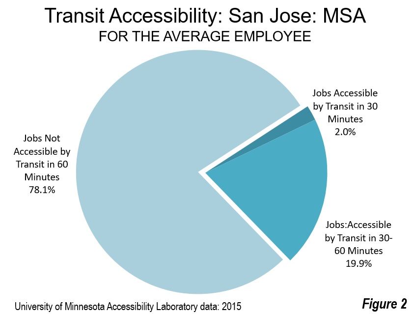
    Government oversight should not discourage deployment of automated vehicles without drivers. Rather it should accelerate the potential for reducing the percentage of single occupant vehicles (SOVs) on streets in all kinds of low speed environments, from congested areas within the densest city centers to suburban residential areas where public transit is now impractical.

    Uber’s semi-robotic taxis in Pittsburgh and Arizona are still Stream 1 technologies, but are trying to make the jump to Stream 2. They are beginning with drivers in the usual position keeping watch on not-quite-ready automation systems, and who are always ready to take over control. So far, human driver intervention remains frequent, around once per mile on average.

    The future date for successful transition of early trial semi-robotic deployments to completely driver-less operation on even a small portion of a metropolitan street grid is uncertain –– although several manufacturers promise by the early 2020s. Operating a region-wide commercial service without drivers may take years of testing and safety certification. Slow-moving mini-bus shuttles staying under 25 mph in a curb lane are easiest to deploy first, and are being tested already in Asia and Europe. A limited version is just now being tested in Las Vegas ahead of passenger service said to be coming within months.

    Stream 2 requires a combination of impeccable up-to-date digital mapping, well-maintained lane markings and signage, all within bounded operating areas. There will be remote human oversight. Governments at all levels are most unlikely to allow autonomous vehicles to roam unmonitored. That’s sensible public policy.

    In contrast, because human driving remains available, vehicle owner-drivers in the less controversial and high-momentum Stream 1 of driver assistance will be able to travel on all types of roads, a practically unlimited operating domain. The auto industry is trying to enable drivers to gain swaths of time to do limited non-driving tasks on limited access highways. Less attentive driving has the potential to become safer, with crashes from driver error less common. The inevitable years ahead for roads that mix automated and non-automated vehicles will challenge and delay the full potential for mitigating distraction.

    Stream 1 drivers with automated assistance will more easily tolerate longer distance commutes that let them access lower-cost housing and closer proximity to outdoor recreation. The daily grind of congested commuting from suburbs to downtowns could be significantly eased for drivers of highly-automated vehicles, who can then focus on non-driving activities.

    By making car travel easier, Stream 1 will be a force of unknown magnitude for making urban areas spread outward. Traffic could increase but would move more smoothly because of automated control assistance. Many consumers will embrace Stream 1, so it will not initially reduce parking demands in our residential areas, employment centers, or shopping districts in the way the slower-arriving Stream 2 promises.

    Stream 1 automated driver assistance appeals to the sense of autonomy and control that comes with car ownership. The driverless Stream 2 supports the rising attraction of efficient ride hailing, ride sharing and taxis. Both are coming, with Stream 1 having the advantage now. But which path of innovation will dominate in the 2020s?

    Stream 1 automated driver assistance has no deployment barriers. It’s simply your next car purchase or the one after. It conforms to every purpose and role that your family vehicle now plays: habit, status, privacy, security, and the sense of assurance you get from owning a car as you and your parents long have.

    The full automation in Stream 2 faces a series of obstacles to everyday use, with gaps in technological capability an even bigger issue than regulatory barriers. For Stream 2 to be realized, drivers must become completely redundant in all circumstances within a geographic range of service. Even with machine learning in computer algorithms, that’s a tough goal. Reaching a near-error-free level of robotic motor vehicle operations over a broad geographic region at the human level of 100 million miles between fatal incidents may be inevitable, but the number of years to get Stream 2 cars to be this safe is still uncertain.

    Eventually, Stream 2 will become the taxicab, the Uber, the Lyft, the ReachNow, and the city bus of the future, reducing operating cost by eliminating drivers. Stream 2 will be battery-electric powered for operation that is quiet, non-polluting, and energy-efficient. Optimists for the automated vehicle’s future are enthusiastic about their potential for making car ownership unnecessary for many people.

    But wait. Consumers will shift away from car ownership only as new Stream 2 on-demand mobility services emerge as suitable for the wide range of personal desires and needs that exist within any typical family. That will require new levels of affordable vehicle availability, range, responsiveness, convenience, choice, comfort and personalization not currently available today, and also not easily reached in the early years of Stream 2 robo-cabs.

    Stream 1 is familiar and can be safely left to new car dealers and existing motor vehicle regulations policy. Stream 2 breaks with current practice, however, providing the biggest opportunity for congestion reduction in the long run. This is where regional and local governments need to focus now by encouraging, facilitating, and funding demonstration projects of the driverless vehicles available now.

    John Niles lives in Seattle. He is a principal with the automated vehicle consultancy Grush Niles Strategic, and is also the Research Director at Center for Advanced Transportation and Energy Solutions (CATES) and a Research Associate at Mineta Transportation Institute at San Jose State University. This essay builds upon a report that his Toronto colleague Bern Grush prepared for The Residential and Civil Construction Alliance of Ontario (RCCAO), issued October 2016,”Ontario Must Prepare for Vehicle Automation.”

    Photo: Flckr user jurvetson (Steve Jurvetson). Trimmed and retouched with PS9 by Mariordo [CC BY-SA 2.0], via Wikimedia Commons

  • To Reunite America, Liberate Cities to Govern Themselves

    Time magazine’s 2016 Person of the Year was elected president, as the magazine’s headline writer waggishly put it, of the “divided states of America.”

    Donald Trump did not, of course, cause America’s long-standing divisions of class, culture, education, income, race, and politics, which have been baked into our geography and demography for a long time. But he has certainly brought them into stark relief. As the social psychologist Jonathan Haidt remarked, “We have to recognize that we’re in a crisis, and that the left-right divide is probably unbridgeable. … Polarization is here to stay for many decades, and it’s probably going to get worse, and so the question is: How do we adapt our democracy for life under intense polarization?”

    The answer lies not in enforcing uniformity from left or right but in embracing and empowering our diversity of communities. The best way to do that is by shifting power away from our increasingly dysfunctional federal government and down to the local level, where partisan differences are more muted and less visible, and where programs and policies can actually get things done.

    This is hardly the first time the United States have been so divided. Yet with the exception of the Civil War, America has always been able to surmount its differences and change as needed over time. Often the most powerful and lasting innovations—from both the left and right—have percolated up to the national level from the grassroots politics of state and local governments, the places Justice Louis Brandeis famously called “the laboratories of democracy.”

    Far from promoting unity, centralizing power at the national level drives us further apart. This is something that the Founders recognized at the very outset of the American experiment when they designed a federalized system, and it is very much in tune with our current national mood. Almost half (49 percent) of Americans view the federal government as “an immediate threat to the rights and freedoms of ordinary citizens,” according to a 2015 Gallup poll. And nearly two-thirds (64 percent) believe that “more progress” is made on critical issues at the local rather than the federal level, according to a separate 2015 Allstate/National Journal Heartland Monitor poll.

    The issue isn’t just the dysfunction of our national government, but how we can best and most efficiently address our economic needs and challenges. The United States is a geographically varied place. No top-down, one-size-fits-all set of policies can address the very different conditions that prevail among communities. Back when he was governor, Bill Clinton understood that “pragmatic responses” by local governments to key social and economic issues were critical in “a country as complex and diverse as ours.”

    Until recently, local empowerment was mostly a theme of the right, for example when Yuval Levin characterized President Obama’s use of executive orders as intrusions on local rights. Now some progressives, horrified about the orders that might come down from a Donald Trump administration, are also seeing the light. Progressives have not always been hostile to local control, as anyone who’s studied the grassroots radical movements of the 1960s well knows. But now a growing chorus of them, including Benjamin Barber and Bruce Katz, are on board with the idea. Indeed, strange times make for strange bedfellows, and we have come to a pass where conservatives and progressives can work together to reinvigorate our federalist state.

    The United Kingdom, long a highly-centralized country, has been making moves in this direction—even before the Brexit vote showed widespread opposition to meddling from an even more distant government in Brussels. In 2015, a blue-ribbon panel of British business leaders, policymakers, economists, and urbanists outlined four key steps to empower cities, including shifting decision-making authority from the national government to cities and metropolitan areas; giving cities greater tax and fiscal authority; placing city leaders on national representative bodies and giving them a permanent seat on the national cabinet; and creating new mechanisms to coordinate major investments in infrastructure, talent, and economic development across metro areas. We would be wise to follow their cue.

    It is time for American mayors and community leaders—from small towns, suburbs and midsized ‘burgs to great metropolitan capitals like New York City, LA, and Chicago to press for a similar devolution of power. Such a strategy recognizes both the advantages that come from local innovation and problem solving and the substantial variations in local capabilities and needs. This need for devolution and local empowerment does not just apply to the federal government; it applies to the relationship between the states and municipalities as well. A greater recognition of local differences may be particularly helpful for suburbs, which often have little voice in regional decision-making compared to either big city mayors or the rural and small town interests that dominate many statehouses.

    In the America that emerged after the Second World War, unity of purpose was the watchword. In the more geographically-varied world of today, it makes sense to allow for a greater variation of policy approaches. Rather than pursuing a single vision of “national greatness,” it’s time for us to embrace and empower the country’s wondrous local diversity of cities, suburbs and communities of all kinds.

    Vive le difference!

    Joel Kotkin is executive editor of NewGeography.com. He is the Roger Hobbs Distinguished Fellow in Urban Studies at Chapman University and executive director of the Houston-based Center for Opportunity Urbanism. His newest book, The Human City: Urbanism for the rest of us, was published in April by Agate. He is also author of The New Class ConflictThe City: A Global History, and The Next Hundred Million: America in 2050. He lives in Orange County, CA.

    Richard Florida is author of The New Urban Crisis, University Professor at the University of Toronto, Distinguished Visiting Fellow at NYU, and editor-at-large of The Atlantic’s CityLab.

  • Transit Ridership Down 2.3% in 2016

    With little fanfare, the American Public Transportation Association (APTA) released its fourth quarter 2016 ridership report last week. When ridership goes up, the lobby group usually issues a big press release ballyhooing the importance of transit (and transit subsidies). But 2016 ridership fell, so there was no press release.

    The report showed that light-rail ridership grew by 3.4 percent, probably because of the opening of new light-rail lines such as Seattle, where the opening of the University line increased ridership by 60 percent. In the past, light-rail ridership has grown with the addition of new lines, but the number of passengers per mile of light rail has fallen, indicating diminishing returns to new rail construction.

    Commuter-rail ridership grew by 1.6 percent, mostly due to growth in New York City. Trolley bus ridership grew by 1.8 percent, almost all of which was in San Francisco. Demand-response (paratransit) grew by 0.7 percent.

    The two most important modes, however, both declined: heavy rail fell by 1.6% and buses by 4.1 percent. Since these two modes together carry 86 percent of transit riders, their decline swamped the growth in other modes. “Other,” which includes ferries, monorails, and people movers, also fell by 0.2 percent.

    In some cases, the decline in bus ridership more than made up for increases in rail ridership. Phoenix light-rail ridership grew by 10.6 percent, but for every light-rail rider gained, Phoenix transit lost nearly four bus riders. Los Angeles light-rail ridership grew by 8.7 percent, but for every light-rail rider gained, Los Angeles lost nearly six bus riders. Ridership on Nashville’s Music City Star grew by 2.6 percent, but the city lost more than 30 bus riders for every new rail rider. Denver opened a new rail line to the airport but lost more than 1-1/2 bus riders for every rail rider gained. Charlotte lost more than 15 bus riders per new rail rider, while Portland lost nearly 2 bus riders per new light-rail rider.

    Other major rail systems couldn’t even record gains. Washington’s Metrorail fell by 10.4 percent; Atlanta fell by 4.7 percent; and the biggest shock of all, New York City subways fell by 0.8 percent. Heavy-rail ridership also feel in in Baltimore (-13.2%), Chicago (-1.3%), Miami (-3.8%), and Philadelphia (-4.5%), among other places.

    Ridership on Boston’s aging subway lines fell by 0.2 percent. As in Washington, the Boston subway is experiencing maintenance problems, including smoke in the tunnels. MBTA has ordered new rail cars, one of which was put on display this week. As columnist Teresa Hanafin noted on Tuesday in the Boston Globe,

    Governor Charlie Baker and state transpo and T officials tour the new Orange Line trains at noon in Medford. The new cars are terrific: They come equipped with sneakers that riders can borrow when the trains break down and they have to walk to the next station, paperbacks to read during the daily delays, hair dryers so riders can help T workers warm up the tracks during cold weather, tasers to ward off gropers, vomit bags, nose plugs, hand sanitizer, and cheese vending machines so riders can feed the rats. Isn’t technology great?

    Light-rail ridership declined in, among other places, Buffalo (-6.1%), Cleveland (-4.7%), Dallas (-1.7%), Minneapolis (-0.2%), Philadelphia (-6.0%), Pittsburgh (-4.3%), St. Louis (-4.6%), and Sacramento (-3.5%). Commuter-rail ridership fell in Albuquerque (-7.7%), Austin (-3.5%), Dallas-Ft. Worth (-6.1%), Los Angeles (-4.3%), Maryland (-1.9%), Miami (-1.6%), Orlando (-8.5%), and Philadelphia (-5.9%), among other places.

    Salt Lake City has been getting more federal transit funding per capita than any other urban area, but the region seems to be losing its bet on light rail and commuter rail. Except for paratransit, every mode of transit in the region declined. The same thing happened in Dallas-Ft. Worth, which has built more light rail than any region in the country. Transit in San Jose, home of one of the nation’s worst-managed transit agencies, took a real nosedive, losing 10.0 percent of light-rail riders and 8.5 percent of bus riders.

    APTA will no doubt blame these declines on low gasoline prices. Prices for regular gasoline in 2016 averaged $2.14, about 12 percent less than 2015’s $2.43. Prices in 2016 were also less variable, which might have given people more confidence in driving. Perhaps more important, per capita incomes grew by 3.5 percent, which probably contributed more to near-record auto sales than low gas prices (though the low fuel prices influenced people’s choices of what vehicles to buy).

    The transit industry bills itself as providing necessary transportation for low-income riders and alternative transportation for choice riders. Whether because of low gas prices, rising incomes, or growing shared-car services, low-income commuters are buying cars and higher-income travelers are making a choice not to use transit. In the face of these choices, transit agencies that want to spend hundreds of millions or billions on fixed-guideway transit, either rail or dedicated bus lanes, are wasting peoples’ money.

    Randal O’Toole is a senior fellow with the Cato Institute specializing in land use and transportation policy. He has written several books demonstrating the futility of government planning. Prior to working for Cato, he taught environmental economics at Yale, UC Berkeley, and Utah State University.

    Photo: Wade Rockett, CC License.

  • The Ghost of Mamie Eisenhower

    There’s a certain amount of nostalgia these days for 1950’s suburbs when men were men and ladies mopped linoleum floors in white pumps and pearls. I’m not entirely sure that world ever really existed precisely the way it was portrayed on black and white television, but we seem to want it to be true.


    Here are examples of the most common version of 1950’s suburban homes. Soldiers returning from World War II eagerly bought them with heavily subsidized mortgages. They were based on the Levittown model of modest mass produced houses stamped out by the tens of thousands in potato fields all across North America. 875 square feet. Three small bedrooms. One bath. A little eat in kitchen. No garage. No air conditioning. And this kind of home was a spectacular improvement over the accommodations most families had experienced during the Great Depression of the 1930’s and wartime rationing of the 1940’s.

    Screen Shot 2016-07-13 at 1.49.17 PM

    Screen Shot 2016-06-04 at 9.43.05 PM

    But by today’s standards these homes are often considered substandard. In fact, in many communities homes like these are now illegal to build because they’re so cheap and unimpressive that they might attract “the wrong element.” This subdivision has been in decline for years. The manufacturing jobs that once supported these families dried up long ago. The next generation who managed to get university degrees and work their way up the economic food chain moved to more exclusive locations farther away from the old city center. The population of this tract has contracted by 17% since the 2000 census. Today the largest segment of the remaining population in this neighborhood earns $10,000 or less per year. Many are elderly pensioners or people on public assistance. Some of these homes languish on the market and eventually sell for as little as $25,000. Homes in better condition consistently sell for $50,000 to $60,000 – largely because banks won’t write mortgages for less.

    If you take a ten minute drive out along the aging 1950’s commercial corridors that compliment these residential subdivisions you quickly discover the scope of the problem. The most common criticism of this environment is that it’s soul crushingly ugly. The presumed remedy is to make it “pretty” by planting flowers, mandating more attractive signage, and flying American flags everywhere. There’s a concerted effort to replace the dead drive-thru burger joints and empty muffler shops with shiny new drive-thru burger joints and muffler shops. But ugliness isn’t the problem and newness isn’t any kind of solution.

    Insolvency is the problem. This landscape doesn’t generate enough value to support the required infrastructure that supports it. The majority of the land along this commercial strip is surface parking lots, landscaped berms, and storm water retention ponds. None of that pays taxes, employs people, or adds value to the town. The best discount tire shop in the world can’t spin off enough revenue to carry the public burden of suburban roads, sewers, water systems, schools, police, and so on. Ugly is just the icing on the cake.

    But then I discovered this bit of Dwell Magazine style new construction. The fashionable Mid Century Modern lines are a kind of Walter Gropius meets Mies Van Der Rohe meets Frank Lloyd Wright homage to Mamie Eisenhower’s bygone Atomic Ranch America with all the latest “green” bells and whistles. So why did someone spend so much money on this property in this location? Well…

    It’s a peculiar sweet spot if you’re paying attention. The schmaltzy 1950’s tract homes are built right on the edge of an old 1890’s neighborhood. When the subdivision was new people were eager to escape the cramped apartments and run down housing stock of traditional urbanism and reveled in the privacy, personal space, and greenery of the fresh suburban living arrangement. They drove away from Main Street on the newly widened highways toward a glorious Jiffy Lube and Dairy Queen future. Meanwhile, the old neighborhood suffered institutional neglect and was abandoned to slumlords and marginalized minority populations for decades.

    Today there’s a renewed appreciation for historic districts. The economic and cultural pendulum is swinging back again, particularly among post college Millennials. The center of this traditional neighborhood is a five minute bicycle ride from those cheap 1950’s tract homes. As prices for venerable properties rise and availability tightens the little tract homes may seem a lot more viable. This is especially true as Millennials begin to have children and start looking for affordable property close to civilization, but with a little patch of garden. Zoning regulations and building codes make it almost impossible to alter existing homes in the older neighborhood. But the small homes and large lots of the suburban subdivision are significantly easier to add on to and modify. These homes can turn away from the depressing sprawl along the highway and turn back toward Main Street. Given enough time and incremental investment this could be one of the more desirable places to live in the years to come.

    And there’s one more aspect to these homes that I find particularly appealing. There’s a significant amount of land that lends itself to serious gardening and a conspicuous lack of Home Owners Association rules and regulations. Combined with the close-in location and genuinely affordable price point these homes are ideal for varying degrees of suburban homesteading. This sort of thing may seem peculiar to most people at the moment, but it could be a prominent selling feature in the future. Time will tell.

    John Sanphillippo lives in San Francisco and blogs about urbanism, adaptation, and resilience at granolashotgun.com. He’s a member of the Congress for New Urbanism, films videos for faircompanies.com, and is a regular contributor to Strongtowns.org. He earns his living by buying, renovating, and renting undervalued properties in places that have good long term prospects. He is a graduate of Rutgers University.

    All photos by Johnny Sanphillippo