Category: Urban Issues

  • New Data on Commuting in Canada

    New data from the National Household Survey indicates that driving to work continues to surge in Canada. In addition to providing work access market shares, the National Household Survey provides one-way work trip travel time estimates for all metropolitan areas.

    The National Data

    Between the 2006 census and the 2011 National Household Survey indicates an increase of nearly 750,000 additional work-bound cars on the road. The increase in driving exceeded the overall increase of 585,000 in employment (Figure 1). Transit also experienced a strong increase, adding nearly 230,000 one-way work trip riders. At the same time, there were declines in car pool passengers (266,100), walking and cycling (52,200), and working at home (87,700).

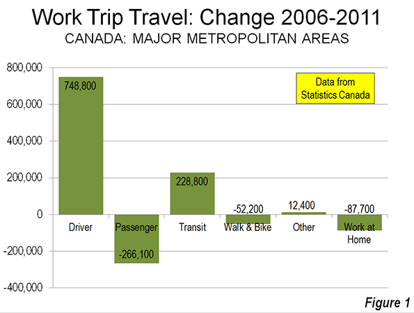
    Driving (whether alone or in a car pool) reached a share of 68.9%, up 2.1 percentage points over the 66.8% registered in the 2006 census. Transit also increased, with its share rising from 10.2% in 2006 to 11.2% in 2011. The big loss was in carpool passengers which dropped from 7.1% to 5.9%. This declining carpool share mirrors the experience in the United States. There were also losses in the combined walking and cycling share, from 7.1% to 6.5% and in the work at home share from 7.7% to 6.9%.

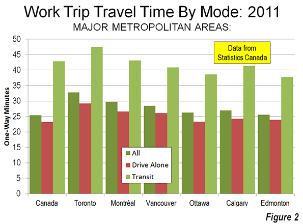
    Overall, the average one-way work trip travel time was 25.4 minutes, not much different than the US average of 25.5 minutes. However, among the major metropolitan areas, travel times generally exceeded those of similarly sized US metropolitan areas (below).

    Major Metropolitan Areas

    The story was similar among the major metropolitan areas (over 1,000,000 population).

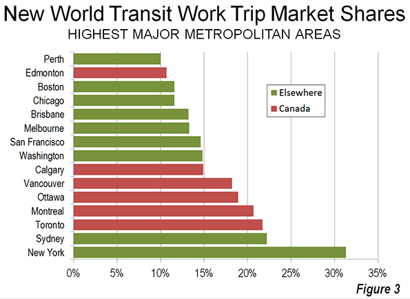
    Toronto: In Toronto, now Canada’s dominant metropolitan area, driving (alone or in car pools) increased from 59.4% to 60.2% between 2006 and 2011. Transit also experienced a full one percentage point increase to 21.7%. This transit work trip market share is higher than any other metropolitan area in Canada or the United States, with the exception of New York, at 31.1%). Toronto’s transit market share trails that of Sydney slightly (22.2%), though is much higher than that in Melbourne. Driving and transit took virtually all of their increase from a 1.9 percentage point loss in carpool passengers.

    Toronto’s one way work trip travel time was 32.8 minutes, which is longer than all other major metropolitan areas and exceeded in the New World only by Melbourne (36 minutes), New York (34.9 minutes), Washington (34.5 minutes), and Sydney (34 minutes). Toronto’s work trip travel time is longer than that of larger Los Angeles (28.6 minutes), as well as similarly-sized Dallas-Fort Worth (26.6 minutes) and Houston (27.7 minutes).

    Montréal: Montréal, the nation’s second-largest metropolitan area experienced a 1.2 percentage point increase in driving, while transit rose 0.7 percentage points. Montréal had the largest decline in carpool passengers among major metropolitan areas, falling from 4.7% in 2006 to 3.2% in 2011.

    Montréal’s average one-way work trip travel time was 29.7 minutes, also longer than the Los Angeles metropolitan area, which has more than three times as many residents. Among the 12 US metropolitan areas between 2,500,000 and 5,000,000 population, only Baltimore (30.3) and Riverside-San Bernardino (31.0) have longer work trip travel times than Montréal.

    Vancouver:Vancouver was the only major metropolitan area with the decline in driving, from 61.7% to 60.9%. Vancouver also had the highest transit market share increase, from 15.1% to 18.2%. Vancouver experienced a huge (1.9 percentage point) loss in carpool passengers and a strong loss in working at home (0.8 percentage points).

    The average work trip travel time in Vancouver was 28.4 minutes. This is nearly equal to that of Los Angeles (28.6 minutes), despite the fact that Los Angeles is nearly five times as large. Vancouver, with a population of 2.3 million has a longer work trip travel time than any US major metropolitan area under 2,500,000 population.

    Ottawa:Ottawa, which includes suburbs in Quebec (across the Ottawa River), experienced the 1.4 percentage point increase in driving and a 0.7% increase in transit use. Ottawa’s transit market share ranks third in the nation. The driving and transit gains were also largely at the expense of carpool passenger and working at home losses. The one-way work trip travel time was 26.3 minutes.

    Calgary:Among the major metropolitan areas, Calgary experienced the largest increase in driving, a 2.7 percentage point increase, from 64.2% to 66.9%. This is the second largest driver market share among the major metropolitan areas. Transit was up a modest 0.4 percentage points, while the share of carpool passengers dropped 1.9 percentage points. Working at home declined by 0.9 percentage points. The one-way work trip travel time was 27.0 minutes, longer than any US metropolitan area in the 1,000,000 to 2,500,000 population category.

    Edmonton:Driving increased 2.1 percentage points from 2006 to 2011 in Edmonton, from 70.5% to 72.6%. Edmonton had the highest driver market share in the nation. Transit was up 1.6 percentage points. Car pool passengers declined 2.2 percentage points and working at home declined 0.7 percentage points. Edmonton’s one-way work trip travel time was 25.6 minutes, the shortest among the major metropolitan areas. Work trip travel in Edmonton takes somewhat longer than the average of 24.5 minutes for US metropolitan areas with from 1,000,000 to 2,500,000 million residents

    Medium Sized Metropolitan Areas

    Five of Canada’s metropolitan areas have between 400,000 and 1,000,000 residents (Quebec, Winnipeg, Hamilton, Kitchener and London). Overall, these areas experienced a 1.9 percentage point increase in driver market share, to 72.4%. Transit was up 0.6%age points to 9.3%. Driving and transit experienced market share gains in each of the five metropolitan areas. As among the major metropolitan areas, the driver and transit gains were principally from losses in car pool passengers. Work trip travel times were below the national average in all but Hamilton.

    Travel Time by Mode

    At the national level, automobile drivers had an average work trip of 23.2 minutes, while transit commuters spent nearly 20 minutes more (42.2 minutes). Transit’s relative travel times were better in the major metropolitan areas, all of which have rapid transit or light rail lines to downtown (25.6 minutes for solo drivers and 41.6 minutes for transit). Even so, the average transit commuter spends nearly two-thirds more time on the way to work than solo automobile commuters (Figure 2)

    Transit’s Market Share

    Among the six major metropolitan areas, five (Toronto, Montréal, Vancouver, Ottawa, and Calgary) have transit market shares greater than all other New World (Australia, Canada, New Zealand, and the United States) major metropolitan areas with the exception of New York and Sydney (Figure 3).

    Policy Implications

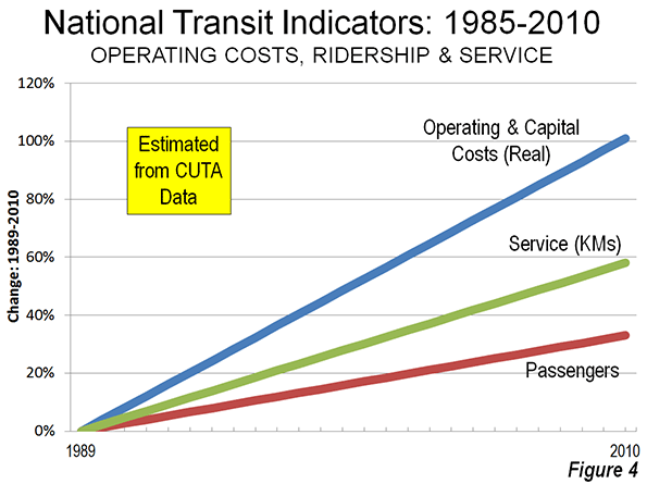
    Major metropolitan areas in Canada have made substantial transit investments (see: Improving the Competitiveness of Metropolitan Areas) in recent years and have seen a strong escalation of operating subsidies (Figure 4). These expenditures did not prevent the substantial increase in driving. Transit’s increase was less than the decrease in car pool passengers. It is possible that many car pool passengers switched to transit, however any such diversion would not have had any impact on the number of cars on the road, but would have only reduced the number of passengers. Driving was up in all the major metropolitan areas, even Vancouver. This seems likely to have increased traffic congestion, which is already substantially worse in Canada than in the United States, though better than in Australia and New Zealand (Note).

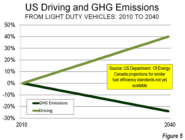
    A principal reason for the increased transit investment has been to reduce greenhouse gas emissions (GHG emissions). However, that impetus is weakening. Canada is adopting strong vehicle emissions standards, virtually identical to the US regulations projected to lead to a huge GHG emissions reduction, even as driving volumes continue to increase (Figure 5). Similar progress seems likely in Canada (projections for Canada are not yet available).

    Table
    Canada: Commuting Market Share: 2006-2011
    2011: National Household Survey Driver Car Pool Passenger Transit Bike Or Walk Other Work at Home
    Major Metropolitan Areas
    Toronto, ON 60.2% 5.1% 21.7% 5.3% 1.0% 6.7%
    Montréal, QC 62.5% 3.2% 20.9% 6.7% 0.8% 6.0%
    Vancouver, BC 60.9% 4.6% 18.2% 7.5% 1.3% 7.6%
    Ottawa, ON-QC 60.0% 6.3% 18.9% 8.0% 0.9% 5.8%
    Calgary, AB 66.9% 5.1% 14.9% 5.7% 1.3% 6.2%
    Edmonton, AB 72.6% 5.2% 10.7% 4.9% 1.3% 5.3%
    Metropolitan Areas: 400,000-1M
    Quebec, QC 72.7% 3.9% 10.8% 7.1% 0.7% 4.8%
    Winnipeg, MB 67.9% 6.9% 12.8% 6.8% 1.3% 4.3%
    Hamilton, ON  73.0% 6.2% 8.7% 5.0% 0.9% 6.2%
    Kitchener, ON 77.0% 6.4% 5.1% 5.2% 0.9% 5.5%
    London, ON 73.4% 6.3% 6.4% 6.4% 0.8% 6.6%
    Major Metropolitan Areas 62.5% 4.6% 19.3% 6.2% 1.0% 6.4%
    Metropolitan Areas: 400,000-1M 72.4% 5.8% 9.3% 6.2% 0.9% 5.3%
    Balance of Canada 75.3% 5.8% 2.8% 7.0% 1.4% 7.8%
    National Total 68.9% 5.2% 11.2% 6.5% 1.2% 6.9%
    2006: Census Driver Car Pool Passenger Transit Bike Or Walk Other Work at Home
    Major Metropolitan Areas
    Toronto, ON 59.2% 7.0% 20.7% 5.4% 0.9% 6.9%
    Montréal, QC 61.3% 4.7% 20.1% 6.9% 0.8% 6.2%
    Vancouver, BC 61.7% 6.5% 15.1% 7.3% 1.1% 8.4%
    Ottawa, ON-QC 58.6% 7.5% 18.2% 8.3% 0.8% 6.6%
    Calgary, AB 64.2% 7.0% 14.5% 6.2% 1.0% 7.1%
    Edmonton, AB 70.5% 7.4% 9.1% 5.9% 1.1% 6.0%
    Metropolitan Areas: 400,000-1M
    Quebec, QC 70.7% 5.1% 9.7% 8.2% 0.7% 5.5%
    Winnipeg, MB 66.2% 8.4% 12.3% 7.1% 0.8% 5.1%
    Hamilton, ON  71.4% 8.0% 8.2% 5.5% 0.8% 6.2%
    Kitchener, ON 73.9% 8.9% 4.5% 6.3% 0.7% 5.7%
    London, ON 70.7% 8.5% 6.3% 7.2% 0.9% 6.4%
    Major Metropolitan Areas 61.4% 6.4% 18.1% 6.4% 0.9% 6.8%
    Metropolitan Areas: 400,000-1M 70.3% 7.6% 8.7% 6.9% 0.8% 5.7%
    Balance of Canada 71.6% 7.7% 2.3% 7.9% 1.4% 9.1%
    National Total 66.8% 7.1% 10.2% 7.1% 1.1% 7.7%
    From Statistics Canada data


    Wendell Cox is a Visiting Professor, Conservatoire National des Arts et Metiers, Paris and the author of “War on the Dream: How Anti-Sprawl Policy Threatens the Quality of Life.

    ——————–
    Note: The INRIX Traffic Scorecard indicates that the average time lost in Canada’s traffic congestion was more than double the US rate (average delay of 15.6%, compared to 6.6% in the United States) in 2012. New data from Tom Tom indicates that traffic congestion is worse in Australia and New Zealand than in Canada.

    Photo: Montreal Centre-Ville (downtown)

  • The Persistence of Failed History: “White Infill” as the New “White Flight”?

    “There is a secret at the core of our nation. And those who dare expose it must be condemned, must be shamed, must be driven from polite society. But the truth stalks us like bad credit.” – Writer Ta-Nehisi Coates

    ***

    With the recent Supreme Courts strike down of the 1965 Voting Rights Act, which was created to protect minority representation, the headline in the Huffington Post read “Back to 1964?” While some contend the title hyperbolic, the HuffPost lead, if not the strike down itself, reflects the reality of a country still tethered to its discriminatory past.

    This reality is reflected in all facets of American society, including urbanism. Specifically, is the “back-to-the-city” movement destined to become 1968 inverted; that is, instead of “white flight” there’s “white infill”? If so, the so-called “game-changing” societal movement will be a process of switching out the window dressing, with the style du jour less lace curtains, more exposed brick.

    While debatable, there appears to be a back-to-the-city trend, particularly the inner-core areas of America’s largest and most powerful cities. For instance, according to a recent report by the Census Bureau, Chicago’s core exhibited a 36% boom in its population from 2000 to 2010—a gain of nearly 50,000. Rounding out the top five core-growth gainers were the cities New York, Philadelphia, San Francisco, and Washington D.C. The report finds that, on average, “[T]he largest metro areas—those with 5.0 million or more population—experienced double-digit percentage growth within 2 miles of their largest city’s city hall…”

    Who is moving into these “spiky” urban cores?

    Whites largely. For example, much of Chicago’s core gains comes from the downtown zip code 60654, in which 11,499 (77%) of the area’s 14,868 incoming residents were white, and where the median family income is $151,000. Other zip codes in Chicago’s core share similar proportions of growth, such as 60605, with 70% of its 12,423 new residents being white. Contrast this with a 5% growth rate for blacks.

    As well, according to research by the Thomas B. Fordham Institute examining the zip codes with the largest growth in the share of white population from 2000 to 2010, 15 of the top 50 were located in Philadelphia, New York, and Washington D.C. Philadelphia’s downtown zip code 19123 grew its population by nearly 40%, and its proportion of whites increased from 25% to almost 50%.  In D.C., the growing core zip code of 20001 increased its white share from 6% to 33% in a mere 10 years. While in Brooklyn, the zip codes 11205 and 11206 showed similar growth dynamics, with overall gains of 15% and 18% respectively, and corresponding increases in the white share of approximately 30%. Also on the Institute’s list are zip codes in not-quite-global cities such as Chattanooga, Austin, Atlanta, St. Paul, Indianapolis, Tampa, and Portland, with the vast majority of the “whitening” areas located in, or besides, the downtown core.

    Now, why does it matter if whites are leading the charge into those cores frequently championed as evidence of a new social order? After all, it is a step forward, right? Or, as urbanist Kaid Benfield recently wrote:

    Inner cities are growing again.  People of means, especially young people, want to be in cities today.  While that carries its own set of challenges, I would submit that addressing the challenges of gentrification is a far better problem to have than coping with massive abandonment and rampant crime.

    While that line of argument has merit, what’s missing is a deeper examination about those “people of means”. Specifically, a recent study out of Brandeis University showed the wealth gap between blacks and whites has nearly tripled over the past 25 years. That said, the people of means wanting to be in cities is largely the same people who always had means, and they are simply taking their means from one geography to the next; that is, from the suburban development to the urban enclave.

    Gap


    Of course many argue that infusing affluence into an area will create broad spillover effects. Tweeted urban planner Jeff Speck:

    “A beautiful and vibrant downtown can be the rising tide that lifts all ships. #walkablecity”.

    Yet there is little evidence of a “trickle down” effect within “rejuvenated” space. For instance, in his piece examining the aforementioned D.C. zip code of 20001, Dax-Devlon Ross writes:

    In 2011 alone, condos accounted for 57 percent of total home sales (276), most at triple the 2000 median price. The zip code now boasts an Ann Taylor, a Brooks Brothers, an Urban Outfitters, enough bars to serve several university populations at once and a mind-boggling 10 Starbucks…

    …What’s telling about the zip code’s “new build” makeover is that it did not move the poverty needle. The zip code’s poverty rate is exactly what it was in 1980, 1990 and 2000 — 28 percent — and the child poverty rate is nearly twice what it was in 1990 (45 percent).

    In other words, such developmental strategy is a game of whack-a-mole in which the raison d’être for the mole won’t stop until real economic restructuring happens, or until equity truly starts entering into the lexicon of our shared language. Instead, we get the apologia of the status quo that is shifting the same affluence to the same pockets, switch out the spatial aesthetics of the parking lot for the parklet.


    Trump Towers Chicago. Courtesy of Northwestern Univ.

    That said, there is real doubt the country has the stomach for such discourse, let alone for policy that can affect the prioritization of human and community capital. From the article “Separate, Unequal, and Ignored”, the author suggests that “[r]acial segregation remains Chicago’s most fundamental problem”, and he questions why the issue remained muted during the recent mayor’s race. Answered Princeton sociologist Douglas Massey:

    “[Segregation] is a very difficult and intractable problem. Politicians don’t like to face up to difficult and intractable problems, whatever their nature”.

    Unfortunately for city proponents, this same inability to face the issue by leading urban thinkers is making the “new urbanism” movement look really old. Asked about the risk of racial and economic homogeneity at the hands of the “back-to-the-city” movement, Alan Ehrenhalt, author of “The Great Inversion and the Future of the American City”, answered this way:

    I think you’re going to have class segregation no matter what you do. It would be nice to have people of all classes living right next to each other in gentrified downtowns. That’s probably not going to happen. It is true that a gentrified area tends to become less diverse. Cities can’t solve all problems.

    No, cities can’t solve all problems. But neither should cities be used to make existing problems worse. Re-urbanism, or specifically the opportunities it creates for equitable reinvestment, should be respected for what it is: a chance to move forward from a divided, destructive past.

    Yet such will take collective will and reflective honesty. Or the ability to look deep in the mirror at the American face and know that behind us is a persistence of failed history.

    Richey Piiparinen is a writer and policy researcher based in Cleveland. He is co-editor of Rust Belt Chic: The Cleveland Anthology. Read more from him at his blog and at Rust Belt Chic.

    Lead photo courtesy of Columbus Underground.

  • A Million New Housing Units: The Limits of Good Intentions

    In May 2013, the district of Husby in suburban Stockholm, Sweden was shaken by “angry young men” engaging in destructive behavior for about 72 hours,1 including the burning of automobiles and other properties and attacks on police officers (over 30 officers were injured). The violence spread to the nearby districts of Rinkeby and Tensta as well as to other parts of Sweden.

    Husby, Rinkeby, and Tensta are located within the corporate limits of Sweden’s capital city,2 but a considerable distance from the waterfront and medieval beauty of downtown Stockholm frequented by visitors and tourists. All three communities were planned in the 1960s and completed in the mid-1970s as part of the Swedish Million Programme.  According to official Stockholm municipal statistics, resident populations in 2012 were 12,203, 15,968, and 18,494 respectively.3

    This ambitious program was approved by Sweden’s Parliament in 1965 to remedy what was then considered an acute shortage of housing. Its goal was to rapidly produce a large number of affordable housing units for the Swedish middle class while preserving nearby open space, improving traffic safety and encouraging residents to walk, ride bicycles and use transit. Planners and architects felt that in order to achieve the desired suburban “new town” environment, development and densities were to be as concentrated as possible, and all units were to be within 500 meters of the transit station.4

    The first new homes in Tensta were delivered to their initial residents in 1967, only two years after the program was approved, but the subway line, so important to the design and development of these communities, was not to be opened to traffic until 1975.

    By the 1970s, the Swedish economy had slowed considerably from its 1960s boom, and as the economy cooled, some areas outside of Stockholm where new Million Programme communities had been built suddenly had a surplus of housing. In Stockholm, production of the Million Programme units continued well into the 1970s until all planned units were completed, even though the population of Stockholm was to decline from 787,182 in 1965 to a modern low of 647,115 in 1981.

    Yet in the end, most of the residents who ended up in these units were neither middle class or of Swedish descent. In part because the Million Programme had eliminated Sweden’s shortage of housing and many of its communities were considered unsightly and undesirable by Swedes, the newly constructed units became places where waves of new immigrants to the country found a place to live. Over time these communities have become suburban ghettos for newly-arrived families and individuals, with persons of an “immigrant background” (either immigrants or the child of immigrants making up between 85% and 90% of resident population in these districts according to official statistics for 2012).  

    These areas soon became isolated from the mainstream of Swedish society. The new communities were designed to make open space accessible to their residents (ordinarily a desirable goal), but this by design disconnected from nearby older (and lower-density) subdivisions. Planners and architects for the Million Programme apparently never anticipated that their creations would become segregated to such an extent that a member of Parliament and government minister would call for some of them to be razed. Sweden’s Minister of Integration, Nyamko Sabuni, did just that in a 2009 op-ed column, when she charged that they led to “exclusion” of their residents and since many of them are badly in need of thorough renovation, some should be torn down instead.5 Indeed some Million Programme complexes outside of Stockholm have met their demise with the use of a wrecking ball.6

    Swedish planners and elected officials did learn from these mistakes. The new high-tech employment center of Kista, located adjacent to Husby, has a base of employment that never developed in the Million Programme districts, and a significantly lower percentage of immigrants (though still higher than 50%). 

    Planners and elected officials in other nations (including North America) should take notice of the Million Programme – and more-recent Smart Growth proposals – as an example of what can go badly wrong.

    The aftermath of Million Programme demonstrates the inability of elected officials and the planners and architects on their staffs to anticipate the future needs and even the demographic makeup of their constituent populations, even in a democratic nation such as Sweden. Though it was approved with wide agreement by the Parliament in 1965, it is unlikely that members of that body anticipated that Swedish middle-class families would reject the densely-developed large-scale apartment developments that the effort produced, nor that much of the wave of immigration that was to arrive on Swedish shores starting in the late 1960s and continuing for many years would end up seemingly confined and segregated in the newly-constructed communities. The problems resulting from the cheap construction methods used and a resulting need for extensive and expensive renovations in order to bring the units up to contemporary standards will require large amounts of money. The source of that funding to make those repairs has not been identified.

    Finally, the role of rail transit in these projects deserves a mention. The construction of the Stockholm subway’s Blue Line (a radial line linking all three communities with downtown Stockholm) was significantly delayed, and did not open for traffic until 1975, well after most of the new homes were occupied, even though a transit station was always intended as an integral part of each of them (prior to 1975, residents had to take buses to get downtown, or get themselves to regional rail stations some distance away).  While the subway system in general (and the Blue Line in particular) are rightly called the “world’s longest art exhibit” because of the extraordinary and diverse beauty of its underground stations, it has not prevented the isolation and economic disadvantage that the minorities living along the line have always experienced. 

    C. P. Zilliacus is a transportation engineer residing in the eastern United States.

    Translations from Swedish by the author.

    Tensta housing photo by Wikimedia Commons user Holger.Ellgaard.

    ——————–

    1           Dagens Nyheter, 2013-05-22, ”Det har blivit värre I Husby de senaste åren” (translates to “It Has Gotten Worse in Husby in Recent Years”)  http://www.dn.se/sthlm/det-har-blivit-varre-i-husby-de-senaste-aren/
    Dagens Nyheter (“The Daily News”) is the largest daily newspaper in Sweden.

    2           Like some U.S. cities, including Houston and Los Angeles, Stockholm annexed significant areas of mostly vacant land during the 20th Century that are now generally considered suburban due to distance from downtown and land use characteristics. 

    3           Municipal statistics for Stockholm obtained online from http://www.statistikomstockholm.se.

    4           A Swedish-language overview of the Million Programme was written by Michael Lindqvist, 2000-05-15 “Miljonprogrammet – planeringen och uppförandet” (“Million Programme – Planning and Construction”), available online http://www.micral.se/miljonprogrammet/Miljonprogrammet.pdf

    5           Dagens Nyheter, 2009-03-20, "Riv i miljonprogrammen för integrationens skull" (translates to "Tear Down the Million Programme Units for the Sake of Integration") http://www.dn.se/debatt/riv-i-miljonprogrammen-for-integrationens-skull/

    6           For an example, see Jan Jörnmark’s photo essay of abandoned Million Programme apartment buildings in the municipality of Laxå, located about 240 kilometers (150 miles) by highway west of Husby: http://www.jornmark.se/places_photo.aspx?placeid=29&Photonumber=001&lang=

  • Suburbia’s Sacred Spaces

    From the earliest times, cities have revolved around three basic concepts – security, the marketplace and what I call "the sacred space." In contemporary America, everyone wants safe streets and a thriving economy, but what about the ethereal side, the places that makes us take note of a place and feel, in some way, a connection with its history?

    What makes up sacred space in our time is debatable. Certainly, the great churches of Europe and the mosques in the Islamic world are the most obvious symbols. In America, we have relatively few such places, but there’s also the sanctity of a war memorial, a monument to a revered leader, concert hall, cherished parks or a sports facility.

    For its part, suburbia is not good at being venerable. It’s not just a matter of age, notes urban analyst Aaron Renn, but also "a lack of transcendent scale." Ceremonial locations, such as New York’s Times Square or Indianapolis’ War Memorial, make "a statement of the permanence of this community, its people, and their values" for an entire region or even state, he notes. Such spaces tend almost always to be built in core cities.

    There is also another factor impinging on the sanctity of suburbia: its lack of permanent establishments. In most suburbs, even the most iconic businesses, notes Renn, tend to go in and out of business. Visit the suburban town that you grew up in, and many of the most cherished spots have gone. This happens in cities, too, but the presence of historic buildings, including old churches, does lend them a greater sense of permanence.

    The very notion of sacred space in suburbia has long seemed absurd to urban theorists, who have regarded suburbia as a hellish place with little in the way of permanency or transcendence. In 1921, Lewis Mumford described the emerging suburbia around New York as a "dissolute landscape … a no-man’s land which was neither town or country." Decades later, architect Peter Blake intemperately declared in "God’s Own Junkyard" that the suburban pattern developing in the United States is "making life there only slightly less tolerable than on tenement streets."

    Yet, ironically, if the greatest "sacred spaces" are in the core cities, those who seek the transcendent are increasingly found far from the dense urban centers, particularly on the East Coast. The most religious cities, according to one recent study, are lower-density areas such as Salt Lake City, Birmingham, Ala., Memphis, Tenn., and Oklahoma City.

    Overall, suburbs tend to be not only where the megachurches are, but increasingly also where the new mosques, Hindu temples and ethnic Christian churches tend to cluster. In contrast, many urban churches in cities such as Philadelphia, New York and Minneapolis often are empty, or even abandoned.

    One trend-setter here is San Francisco – perhaps the ultimate mecca of the secularized "creative class" – where a large former Catholic church, now shuttered, is being turned into an art academy. In many cities, such as ultra-secular Seattle, religious structures are being routinely refashioned into high-end condos and loft spaces.

    So, if religious folks cluster in suburbs, where there is insufficient "sacred space," urbanites live amidst spiritual and symbolic splendor, but feel very little attachment to the religions that inspired them. Indeed, the places idolized as pillars of successful urbanism – think of places like Seattle, Boston, San Francisco or Manhattan – tend to be less religious, while cities with more of a strong spiritual commitment, such as many in the South, are seen as somewhat backward.

    As the urban booster Richard Florida puts it, the shift from religious to secular values is “one part of the transition to more economically advanced societies.”

    Whether one accepts this thesis, it’s pretty clear that most urbanists today have little or no use for religion. This even has crept into discussion of the urban past. Britain’s Peter Hall, for example, wrote a thousand-page history, “Cities in Civilization,” with hardly any reference to religion. Religious institutions rarely appear in the writings of new urbanists, smart-growth advocates and others who tend to also disdain suburbs.

    So perhaps we need to look elsewhere than even grand church buildings or old synagogues for “sacred space.” Emphasis on historic and grand places should be supplanted with greater attention on the activities of those who worship and perform charity, even operating out of more prosaic places. When I worked in Houston after the Hurricane Katrina disaster, the leading institutions helping the evacuees were not the established mainline churches, but the often vast evangelical ones, many of them housed in uninspiring barn-like structures on the suburban frontier.

    In other words, rather than focus on buildings, perhaps we should look at function. What is the most sacred thing in our lives? This could easily be a place where children can play; the parks in places like Irvine or the new Riverside County community of Eastvale, outside Ontario, serve as a kind of sacred space amidst prosaic buildings, malls and strip shopping centers. Perhaps we need to redefine continuity to be less about stylish brick and mortar and more about what animates peoples’ feelings about place and their connections to it.

    This may be, in particular, the essence of suburban “sacred space.” Suburban community has its own unique iconography of recreation centers, parks and smaller religious bodies; yet, these places also constitute the connective tissue of suburbia. When UC Irvine’s Jan Brueckner and Ann Largey conducted 15,000 interviews across the country, they found that, for every 10 percent drop in population density, the likelihood of people talking to their neighbors once a week goes up 10 percent, regardless of race, income, education, marital status or age.

    This is something I see every day in my own San Fernando Valley suburban community. Not only are there strong ties here among neighbors, but many belong to various faith communities, ranging from African-American evangelical churches, to Armenian orthodox as well as every variety of Judaism, from reform to the ultra-religious “black hats.” For many of us, the “holy places” include the trees, which grow luxuriously here, and the many birds, small mammals and variety of insects that share space with us.

    In the end, I would argue that “sacred space” in the current context is basically about home – those places where one has lived, children have played, pets have lived out their lives and where holidays, religious or not, are shared with neighbors. Suburbia not only does not negate this kind of sacred space but, in a surprising way, nurtures it.

    In his brilliant book, “Holyland: A Suburban Memoir,” author D.J. Waldie writes about growing up in the Orange County-adjacent, suburban tract development of Lakewood. He still lives there, and believes that, for millions of Americans – like his parents – these modest communities represented something very inspiring, a place to raise children, go to church, know the neighbors.

    “I actually believe that the place where I live is, in the words of the Californian philosopher Josiah Royce, a ‘beloved community,’” Waldie said last week. “The strength of that regard, Royce thought, might be enough to form what he called an ‘intentional community’ – a community of shared loyalties – even if the community is as synthetic as a tract-house suburb.”

    Lakewood, he notes, is a place that urban planners would like to have seen “bulldozed away years ago to make room for something better,” yet the people there, increasingly Latino and Asian, do not feel their suburb is the invidious thing reviled in urban-studies program or criticized by advocates of forced densification. These are places that people adhere to, Waldie says, even if the appeal is difficult for outsiders to appreciate.

    “I believe that places acquire their sacredness through this giving and taking. And with that ever-returning touch, we acquire something sacred from the place where we live. What we acquire, of course, is a home,” he suggests. “It’s a question of falling in love … falling in love with the place where you are; even a place like mine … so ordinary, so commonplace, and my home.”

    Joel Kotkin is executive editor of NewGeography.com and a distinguished presidential fellow in urban futures at Chapman University, and a member of the editorial board of the Orange County Register. He is author of The City: A Global History and The Next Hundred Million: America in 2050. His most recent study, The Rise of Postfamilialism, has been widely discussed and distributed internationally. He lives in Los Angeles, CA.

    This piece originally appeared at The Orange County Register.

    Suburbs photo by Bigstock.

  • Public Unions for Private Benefits: Public Sector Unions Enrich their Members by Distorting State Finances

    Concerned citizens of California are already familiar with the undue political influence of California’s prison guard union. According to Tim Kowal of the Orange County Federalist Society, the union raises $23 million dollars per year and spends $8 million of it lobbying. As a result, the state has found it impossible to engage in meaningful reform of its correctional system. The union helped defeat a 1999 bill allowing alternative sentencing to select parole offenders and attempts in 2000 and 2008 to provide substance abuse treatment for nonviolent drug users as a substitute for prison sentences. Such laws remain on the books that keep nonviolent criminals in prison, keeping prison guards in high demand with enviable job security.

    Experience shows that when public sector unions become powerful, they can influence the democratic process to secure promises of future benefits. These benefits are ubiquitous; a recent investigation uncovered that many Chicago police officers are eligible to receive annual six figure pensions upon retiring at age 50. In no way are these promises in the public interest. And the real fiscal crisis in America, at the state and local level, looms in states where public sector unions are out of control.

    Unions want more benefits and politicians would rather not incur the wrath of their constituents by raising taxes. To serve both masters, politicians incur more debt. But off the books, they also make completely unrealistic promises about retiree health benefits and pension plans. The promises are known as an unfunded liability – a promise to pay without a source of funds attached to it. Our research, “The Public Sector ‘Union’ Effect: Pushing up Unfunded Pension Liabilities and State Debt” published by The Beacon Hill Institute, establishes a convincing link between the strength of public sector unions and both public failures.

    For California, for instance, we attribute 42.8% of state and local debt to unions. This amounts to $173 billion dollars. We arrived at this conclusion by finding that, after controlling for other factors, a one percentage point increase in membership in public sector unions will lead to an increase in state and local debt by $78 per person. So, if the percentage of public sector employees increases from five to six percent, then we predict that public debt would eventually increase by $78 times the population of the state.

    In California, 58.7% of public sector employees are unionized – it isn’t even the most unionized state. The states in which public debt is most attributable to unions are Iowa (55.2% of their debt), Montana (54.3%), and Michigan (54.2%). The states which can least credibly attribute their fiscal problems to unions are Virginia (10.3%), South Carolina (11.8%), and North Carolina (12.8%).

    But this is only side of the problem. Unfunded liabilities are not included in these figures. The Pew Center on the States has elsewhere analyzed how well states are managing their public pensions and retiree health care benefits. For each of these, Pew rated states as a “Solid Performer,” “Needs Improvement,” or has having “Serious Concerns.”  California was one of several states to have “Serious Concerns” for both.

    There was only one state rated by Pew as having both liabilities under control, Wisconsin. To accomplish that, Governor Scott Walker expended a great deal of political capital to limit unions, and paid for it by nearly being recalled.

    To critically analyze this, we constructed an index out of Pew’s two ratings. For each unfunded liability, we assigned a “0” for states with “Serious Concerns,” a “1” for “Needs Improvement,” and a “2” for “Solid Performer” Then, we summed the two ratings together. States like California that are performing poorly in both have a total score of 0 in the index. Wisconsin received a total score of 4. Any state that receives a total score of 0 or 1 is poorly managing its liabilities.

    More detail is available in the paper, but one way of summarizing our results is this: After controlling for other relevant factors, a one percentage point increase the proportion of public sector employees who are unionized makes it one percent more likely for the state to receive a total score of 0 or 1. This demonstrates the link between unfunded liabilities and pressure from unions.

    The combination of high public debt and the specter of a drastic increase in costs to pay for retiree benefits constitute a recipe for disaster. If the issue is ignored, states like California will experience problems very similar to what European countries like Greece and Spain are now experiencing. Similar austerity measures would mean cuts to basic services and the highest state tax rates seen in US history to avoid bankruptcy.

    Responsible citizens and politicians should recognize the lethal pairing of high debt and poorly funded pension plans. And there is a clear relationship between poor state performance and the power of public sector unions. Engaging in real reform, as was accomplished in Wisconsin, may be politically costly, but it is the best path to allow democracy to function effectively once more.

    Ryan Murphy, PhD, is a research associate at the Beacon Hill Institute at Suffolk University.

  • The Hall of Gimmicks

    Occasional Urbanophile contributor Robert Munson has talked about how Chicago Mayor Richard M. Daley was among the first to recognize that there was a “taxpayer strike” in America. That is, given the breakdown in the social contract in our cities, taxpayers were increasingly unwilling to pour money down a rat hole.

    Localities have also been in a fiscal vice as their tax receipts have collapsed thanks to the Great Recession and especially the decline in housing values, while at the same time the chickens are coming home to roost from the accumulated unfunded liabilities that had been racked up from sweetheart pension deals and the like.

    And state and federal retrenchment have cut into municipal budgets. Aid to municipalities is easy to cut. Also, it’s easy for states to make municipalities bear the brunt of tax caps and other disempowerment items since living with them is Somebody Else’s Problem for state office holders. And most states radically under-empowered local governments to begin with.

    Combine these and there’s little room to maneuver for many cities and mayors. They are hemmed in on all sides. So what do they do? Unsurprisingly, they’ve increasingly turned to gimmicks, especially in bigger cities that have the talent firepower to dream them up.

    Exhibit A is parking meter lease in Chicago. It generated $1.2 billion in “free money” for Mayor Daley to use to paper over deficits, but at a huge long term cost. We’ve seen all sorts of other “public-private partnership” type deals that accomplish similar things. Many of these are not per se problematic – I’m a fan of privatization done right, for example – but the details can be troublesome when you examine them.

    One common complaint I hear in places like Chicago and Indy is the abuse of Tax Increment Financing (TIF). Without a doubt TIF has been abused in a number of cases. But what critics fail to take into account is that TIF is one of the few tools left in the civic toolbox that can actually raise real money.

    Let’s say we are all opposed to gimmicky privatization deals and TIF to raise money. Now let’s ask the question: how are our cities supposed to pay to rebuild their obsolete infrastructure like pothole-ridden streets that, even if they were already pristine, don’t meet modern 21st century demands? This is a real liability of the city, accrued over the years as previous generations failed to keep up with maintenance and such. Absent gimmicks, how is this supposed to be funded? And if the answer is don’t fund it, then how is a completely run down, dilapidated city with creaky services supposed to retain choice consumers who can easily pull up stakes and move to a new suburb or other part of the country that doesn’t have these problems? It’s easy to criticize, but solutions are needed.

    Munson thinks that we need to have accountability reforms so that the public will be convinced to open their wallets and invest. I agree this is critical. I personally have no desire to pour any more of my money into the local treasury until I can see that I’m going to get some return on it. And there’s evidence that the public will spend if you can demonstrate that. Capital bonds and actual tax increases for things like schools, transit systems, stadiums, and even cultural facilities have frequently passed across America when there’s assurance that the money is ring-fenced. When people know that they can vote for a tax and get something tangible for it, even something as dubious as a stadium, they can be convinced to vote for it. But more money for fewer and worse services is a loser every time.

    The problem is that the state controls the fiscal levers. Therefore there’s no guarantee that even if a city got its house in order, it would even be permitted to ask its residents for more money. Also, too many local leaders are beholden to special interests and so are unlikely candidates to deliver reform anyway. Paddy Bauler eloquently summed up this mindset when he famously said, “Chicago ain’t ready for reform.” Sadly, this remains true in all too many places.

    So while the use of gimmicks may be distasteful (and even destructive in the long term at times), we should expect more of it since the incentives are all aligned to produce this outcome. Those cities that do manage to reform, and get state support for the type of legal framework the need to operate (as called for in The Metropolitan Revolution) will be the ones that end up with long term success.

    Aaron M. Renn is an independent writer on urban affairs and the founder of Telestrian, a data analysis and mapping tool. He writes at The Urbanophile, where this piece originally appeared.

    Chicago parking meter photo by Ed Fisher.

  • Crime Down in Urban Cores and Suburbs

    The latest data (2011) from the Federal Bureau of Investigation (FBI) Uniform Crime Reports (UCR) indicates that violent crime continued to decline in both the suburbs and historical cores of major metropolitan areas (over 1,000,000 residents). Since 2001, the rates of decline have been similar, but contrary to media reports, the decline has been slightly greater in the suburbs than in the historical cores. Moreover, despite the preliminary report of a slight increase in the violent crime rate at the national level in 2012, substantial progress has been made in making the nation safer over the past 20 years.

    Major Metropolitan Area Trends

    The FBI website includes complete data on 48 of the 51 major metropolitan areas for 2011 (2012 data are not yet available for metropolitan areas). The FBI notes that the data collection methodology for the city of Chicago and the suburbs of Minneapolis-St. Paul is inconsistent with UCR guidelines and as a result, the FBI does not include information for these jurisdictions. No data is reported for Providence.

    Among these 48 major metropolitan areas, the violent crime rate was 433 (offenses per 100,000 population known to the police), approximately 10% above the national rate of 392 in 2011. The violent crime rate in the historical core municipalities, or urban core (See Suburbanized Core Cities) was 911 offenses per 100,000 population. In the suburbs, which consist of all municipalities not comprising the historical cores, the violent rate was 272 offenses per 100,000 population. Thus, the urban core violent crime rate was 3.3 times the suburban violent crime rate (Figure 1).

    A comparison of the urban core and suburban crime rates by historical core municipality classification further illustrates the lower crime rates generally associated with more suburban areas. The violent crime rates in the more suburban urban cores are generally lower (Table 1). 

    • Among metropolitan areas with “Post-War & Suburban Core Cities,” the urban core violent crime rate in 2011 was 2.2 times that of the suburbs. This would include core cities such as Phoenix, San Jose, Austin and others that became large metropolitan areas only after World War II and the broad expansion of automobile ownership and detached, low density housing.
    • In the metropolitan areas with “Pre-War & Suburban Core Cities,” the urban core violent crime rate was 3.1 times that of the suburbs. These would include core cities such as Los Angeles, Seattle, and Milwaukee, which combine a denser pre-war inner city with large swaths of post-World War II suburban development within their borders.
    • The greatest difference was in the metropolitan areas with “Pre-War & Non Suburban Core Cities,” where the urban core violent crime rate was 4.4 times that of the suburbs. These would include such core cities as New York, Philadelphia, Boston and others, which had large areas of high density and significant central business districts before World War II, and which, even today, have little post-World War II suburban development within their borders.
    Table
    VIOLENT CRIME RATES: HISTORICAL CORE MUNICIPALITIES AND SUBURBS: 2011
    Violent Crimes Reported per 100,000 Population In Major Metropolitan Areas
    Historcial Core Municipality Classification Metropolitan Area Urban Core Suburbs Urban Core Times Suburbs Crime Rate
    Pre-War Core & Non-Suburban 436 1,181 273 4.3
    Pre-War Core & Suburban 443 821 265 3.1
    Post War Suburban Core 398 642 294 2.2
    48 Major Metropolitan Areas 433 911 272 3.3
    No data for Chicago, Minneapolis-St. Paul and Providence


    Suburban and Urban Core Trends: 10 Years

    Over the past decade, violent crime fell both in the suburbs and the urban cores. Among the 36 major metropolitan areas for which complete and comparable data is provided on the FBI website, the violent crime rate fell an average of 25.8 percent between 2001 and 2011. Urban core violent crime rates were down 22.7 percent, while suburb violent crime rates were down a slightly less 26.7 percent (Figure 2).

    Reconciling Differences with Other Analyses

    Other analyses have noted that urban core crime rates are declining faster than in the suburbs. The differences between this and other analyses are due to the use of different time periods, different metropolitan area sets, and most importantly, profoundly more limited definitions of the suburbs.

    An article in The Wall Street Journal raising concerns about suburban crime rates was based on an FBI analysis of all metropolitan areas, not just major metropolitan areas and covered 2001 to 2010. Crucially, the FBI classifies much of suburbia as not being suburbs. The FBI defines suburbs generally as any municipality in a metropolitan area with fewer than 50,000 residents as well as areas patrolled by county law enforcements agencies. Non-core municipalities with their own law enforcement that have 50,000 or more residents are not considered suburbs, regardless of their location in the metropolitan area. This would mean, for example, that Pomona would not be considered a suburb, despite its location 30 miles from Los Angeles City Hall, on the very edge of the metropolitan area, simply because it has more than 50,000 residents. As a result, the crime rates in “cities” versus suburbs cannot be determined by simply comparing FBI geographical classifications.

    A Brookings Institution report reported suburban violent crime rates to be dropping more slowly than in “primary cities,” which are a subset of the “principal cities” defined by the Office of Management and Budget (OMB). Many of these primary cities are virtually all post-World War II suburban in form. These include, for example, Mesa, Arizona, Arlington, Texas and Aurora, Colorado, each of which had fewer than 10,000 residents in 1950 and are virtually exclusively the low-density, automobile oriented suburban development forms that would be found in nearby Tempe, Grand Prairie, and Centennial, which are defined as “suburban” in the Brookings classification. The Brookings report looked at major metropolitan areas as well as smaller metropolitan areas and covered a longer period (1990 to 2008).

    OMB, which defines metropolitan areas, does not designate any geography as suburban. OMB specifically excluded “suburban” terminology from its 2000 metropolitan area criteria. Instead, in recognition of the increasing polycentricity of metropolitan areas, OMB began designating “principal cities.” Except for the largest city in a metropolitan area, principal cities are defined by the strength of their employment markets, and are generally suburban employment centers, not urban cores. In defining its metropolitan area criteria for the 2000 census, OMB recognized  that the monocentric city (metropolitan area) had given way to an urban form with multiple employment centers, located throughout the metropolitan area.

    OMB’s principal cities may be located anywhere in the area, without any relationship to the urban core. Rather than a single core city in a metropolitan area, OMB has designated up to 25 principal cities in a single metropolitan area.

    The National Trend

    The metropolitan area crime reductions are consistent with a now two-decade trend of substantially improving crime rates. This is despite preliminary data recently released by the FBI in June indicating a reversal of the trend for 2012. The FBI reported violent that violent crime increased 1.2 percent. With a 0.7 population increase from 2011 to 2012, the US violent crime rate would increase to 394 per 100,000 residents, from 392 in 2011. Metropolitan area data for 2012 is not yet available.

    This increase in crime rates should be a matter of concern. The 2012 violent crime rate increase is, hopefully, only a blip in a decline that will soon resume. The violent crime rate has declined eighteen of the last 21 years. Since 1991, the violent crime rate has dropped by nearly half (48.3%).

    This is in stark contrast with the previous 30 years, during which the violent crime rate increased in all but five years. By 1991, the violent crime rate had increased 3.7 times from 1961. By 2012, the national violent crime rate had fallen to the lowest level since 1970 (Figure 3).

    Why Has the Crime Rate Declined?

    There are multiple theories about the causes of the crime rate reduction. The late James Q. Wilson, who with George Kelling advanced the “broken windows” theory of crime prevention, offered a number of additional reasons for the fact that crime rates remained much lower, even during the Great Recession, in a Wall Street Journal commentary. The earliest and best publicized improvements in crime rates occurred under New York Mayor Rudolph Giuliani in the 1990s. Kelling and others (such as Hope Corman of Rider University and Naci Mocan of Louisiana State University) attribute much of the crime rate improvement in New York City to the “broken windows” deterrence strategies.

    The substantial decline in violent crime rates, in the nation, metropolitan areas, suburbs and urban cores, are an important success story. Yet, crime rates can never be too low. It can only be hoped that future years will see even greater reductions.

    Wendell Cox is a Visiting Professor, Conservatoire National des Arts et Metiers, Paris and the author of “War on the Dream: How Anti-Sprawl Policy Threatens the Quality of Life.

    Crime scene photo by Alan Cleaver.

  • Angry Young Men

    “’Angry young men’ lack optimism.” This was the title of a BBC News story earlier this year, exploring the deeply pessimistic views that some young working class British hold about their own future. Two-thirds of the young men from families of skilled or semi-skilled workers, for example, never expect to own their own home. Angry young men, this time of immigrant origin, were also recently identified as the group causing riots in Swedish suburbs such as Husby. As Swedish Prime Minister Fredrik Reinfeldt noted, the riots were started by a core of “angry young men who think they can change society with violence”.

    The social unrest occurring in Western Europe is often ascribed to the lack of integration into society among immigrants. It is true that dependency of public handouts rather than self-reliance has become endemic in Europe’s well‑entrenched and extensive welfare states. In Norway for example, the employment rate of immigrants from Asia is only 55 percent, compared to 70 percent for the non-immigrant population. Amongst African immigrants the figure is merely 43 percent.  In neighboring Sweden, a recent government report noted that the employment rate of Somalians was merely 21 percent. This can be compared to 46 percent in Canada and 54 percent in the US for the same group. The low incentives for transitioning from welfare to work in Sweden and Norway compared to in Canada and the US explain at least part of this difference.

    But a failure of integration is hardly the sole explanation for the social unrest which extends well beyond immigrant youth. Why not add another relevant perspective to the puzzle, namely the increasing marginalization that some young men feel across the continent? This frustration is hardly an excuse for violence, but relates to important social phenomena which deserve to be explored, and targeted with the right policies.

    Youthful exclusion from the labor market constitutes a major challenge to European economies. Unemployment for European youth is in many countries more than twice the level of adult workers. The youth unemployment in advanced economies is, according to the International Labour Organization, estimated at an average level of 18 percent. Some countries, such as Switzerland, Austria and Germany, fare relatively well with a rate below ten percent. In others, such as the UK, France and Sweden, around one in five of the youth is unemployed. In Spain and Greece the share recently peaked at a rate of one in two.

    It is hardly news that youth who face unemployment have a tendency to become angry, and to translate this anger to violence. What has become increasingly evident is how much this situation pertains particularly to men. 

    To begin with we can see that a number of societal trends in particular favor women’s career opportunities. Girls tend to perform better in school, regardless of class, place of residence or ethnicity. Young women also, not only in developed countries but even globally, now constitute the majority of students in higher education. Another important change which in particular benefits women’s career opportunities is urbanization. Large cities attract talented young people like magnets. The attraction tends to be greatest for young women, who find employment and opportunities for entrepreneurship in the sprawling service sectors. Men who remain behind in less densely populated areas sometimes struggle to find both work and a spouse.

    As a whole, we have little reason to feel sorry for men in the labor market. Since women still take the primary responsibility for children and family, men can on average invest much more time on their careers and thus more often reach the top. But while some men succeed, others fall behind. Men end up dominating not only the top of society but also the bottom. After having failed in school, many men face rejection in both the labor market and the marriage market. They are left with little in terms of social capital, in terms of valuable know-how and established social networks.

    One reason for why frustration grows is that for men the link between success in work and success in finding a partner is very strong. Men without higher education for example face a higher chance of never becoming a parent, whilst men with higher degrees face the lowest chance (the relation is the opposite for women, where the individuals with higher education face the highest risk of remaining childless).  Extreme opinions, racism and violence are not uncommon among young men who feel they have little chance of making their way in society.

    We should of course stress individual responsibility. But awareness of the alienation felt by some young men has the danger of morphing into a considerable long-term problem, even in wealthy European nations. In previous generations, a considerable amount of “simple jobs" existed in manufacturing, forestry, agriculture and the like which were suited for young individuals with limited education. Today, such jobs are far less available.

    Part of the explanation is that technological changes and increasing global competition are pushing the labor market towards higher degree of specialization. Another reason is that policies in many modern countries, due in part to bureaucratic regulation, work to slow industrial development. Although industrial job growth is clearly possible and very promising in developed nations, many politicians wrongly believe that new industry has no future in rich Europe.

    The lacking interest to open up for growth in manufacturing is combined with the fact that education systems in countries such as the UK and Sweden are not good at encouraging students with low academic interest to ready themselves for manufacturing and other technical jobs – the situation is much different in for example Germany and Switzerland, with promising apprentice systems. In addition a strong social stigma has begun to become associated with not having a higher degree. This prompts individuals to choose even university courses that aid them little if any on the labor market, rather than take available simple jobs and climb the career ladder by developing practical knowledge.   

    Frustrated young men should never be excused in their acts of violence. But we must take their lack of hope seriously. Both policies and the education system should be reformed, so that the simple entry-level jobs that are suited for young men who lack academic skills or interest are opened up. Such policies would as an added bonus boost growth, employment and in particular benefit smaller cities and rural regions. We surely need ample policies to boost women’s’ career opportunities and entrepreneurship, but we should also recognize the challenges tied to the increasing marginalization for the men who feel little hope of progressing in society by following the rules.

    Dr. Nima Sanandaji is a Swedish author of Kurdish-Iranian origin. He has written two books about womens carreer opportunities in Sweden, and is upcoming with the report “The Equality Dilemma” for Finnish think-tank Libera.

    Husby riot photo by Wiki Commons user Telefonkiosk.

  • Cities Still Being Squeezed

    Recent announcements of state budget surpluses have led to the popping of corks across the deepest-blue parts of America, particularly here in California. In some cases, the purported fiscal recovery has been enshrined by an emerging hagiography about Jerry Brown’s steadfastness in the face of budget debacles. One prominent piece even argued that the “smart, bold progressive movement” actually “saved” the Golden State, in part, by forcing up income tax rates.

    Yet, as Walter Russell Mead, among others, has argued, the states’ fiscal meltdown has not been averted, but simply delayed, by the current asset-driven economic recovery. Taken together, the states owe $1 trillion in unfunded pension obligations alone. These costs are eating up much of the projected surpluses, even in prosperous and relatively frugal states such as Texas.

    But the first place where the fiscal blowout will hit the road may be at the local level. This is, in part, because one way that states try to improve their balance sheets is by cutting aid to localities while imposing new mandates dealing with everything from housing to green policies. This has occurred in such places as Pennsylvania, Massachusetts, New Jersey and New York.

    “Quietly and without fanfare, governors and state legislators approved overly generous pension packages, let stand costly, antiquated laws and continued to shift costs from Albany to our front doors,” noted one upstate New York newspaper.

    So, even as state budgets improve somewhat, municipal budgets remain very vulnerable to cutbacks. Pew reports that both state aid and property-tax collections have continued to drop, something that perhaps will be slowed by a developing bubble in real estate values.

    Similarly, according to a report by the National League of Cities, city financers at the end of 2012 projected a sixth consecutive year of year-over-year declining revenue. The ability of localities – particularly the most-distressed – to endure this pattern much longer is somewhat dubious.

    In fact, the run up to a wave of municipal bankruptcies has begun. Seven major municipalities have already filed for bankruptcy, the largest being the city of San Bernardino. To a large extent, these bankruptcies are being driven by unfunded obligations for employee pensions. A new study by the Brookings Institute “estimated that the aggregate unfunded liabilities of locally administered pension plans top $574 billion. … On average, pensions consume nearly 20 percent of municipal budgets.” But the worst is yet to come. “[I]f trends continue, over half of every dollar in tax revenue would go to pensions, and, by some estimates, in some cases, would suck up 75 percent of all tax revenue.”

    This has locked many localities across the country into a classic vicious cycle as they try to dig their way back to growth. Unless radically reformed, health care and retirement obligations to employees seem certain to outweigh the ability to fund necessary government functions, the very things – infrastructure, public safety and other economic development components – necessary to nurse a region and its governments back to health.

    By far, most vulnerable will be those cities with high unemployment, rising crime and tepid recoveries. These will include many of America’s most violent cities – Detroit, Cleveland, St. Louis, Chicago, Memphis, Tenn., – as well as those with generally dysfunctional schools and decaying infrastructure. The idea of cutting police services in such places would invite even greater deterioration of public order.

    This process of small-scale deterioration is already well advanced in California. When it comes to buck-passing to the local level, no one can outdo the Golden State. Gov. Brown’s “realignment” strategy put the responsibility for state justice programs largely on local governments (though this came with promises of increased state aid). Brown also oversaw the dissolution of the state’s 400-plus redevelopment agencies, some of which may now be forced into bankruptcy. Many cities consider these agencies, which provide tax relief to businesses, as one of their most effective economic development tools. So, while state debt is expected to decline by $1.7 billion next year, local-government debt in California is actually set to increase by $600 million.

    Many counties and localities risk also losing their health care benefits under Gov. Brown’s revised fiscal year 2013-14 budget. These changes will be hardest on those localities with the biggest problems, notably some smaller cities already tilting on the edge of bankruptcy. As many as 10 others, including Oakland and San Jose, could join them. Many others are simply cutting back; Sacramento is now asking newly recruited police officers to pay into their pension plans before joining the force.

    These problems also are deeply entrenched in the state’s largest city. Los Angeles, more than any of the top 10 cities in the country, with the possible exception of Chicago, still suffers from quasirecessionary conditions. Not surprisingly, L.A.’s budget situation, in large part due to pension and other employee-related costs, remains perilous. A former mayor, businessman Richard Riordan, has predicted that, unless pensions and compensation are reformed dramatically, the city will eventually slide, inexorably, toward bankruptcy.

    The primary culprit in this slide, notes Riordan, has been the political domination of Los Angeles, and other cities, by public employee unions and the lack of true political competition. The original poster child for this is San Bernardino, where labor costs consumed 80 percent of the city budget, in large part due to public-sector unions’ investment in local political races.

    Bigger and somewhat economically stronger, Los Angeles may not soon go the way of San Bernardino, but its fiscal problems remain severe, with a projected $800 million deficit over the next four years and pensions that are underfunded by at least $15 billion. Clearly, these shortfalls will continue to undermine the city’s ability to keep its streets safe, roads paved and parks operating – until City Hall is willing to stand up to the public-sector lobby.

    The most recent citywide election was not too comforting in this regard, since both candidates for mayor were reliable allies of city worker unions. But, at least, it should be noted that the loser, Wendy Greuel, was, in part, defeated by revelations of her massive financial backing from those unions. It almost certainly hurt her standing with what should have been her base among more conservative, quasisuburban voters from her “hood” – the San Fernando Valley.

    Yet, even if incoming mayor Eric Garcetti can right the ship, residents of Los Angeles are likely to face a combination of rising taxes and fees for years to come to address soaring pension costs. Given the financial drag of pension and other employee benefit obligations, even traditional city services, such as street repair, will likely need to be funded by additional debt or fees on property owners.

    Short of major reform, this self-defeating pattern of higher local taxes and fewer local services is likely to continue even if state economies and budgets climb out of their recent distress. Yet, at the same time, this presents an opportunity to rebalance the relationship between private- and public-sector interests.

    If good habits are learned first in the home, perhaps the road to fiscal health will have to begin at the local level. Sacramento and other state capitals have demonstrated skill at kicking the can down the road while shirking their responsibilities to local governments. Instead, it may fall upon the localities to come up with ways to overcome decades of poisonously irresponsible decision making and concoct the proper fiscal antidote.

    Joel Kotkin is executive editor of NewGeography.com and a distinguished presidential fellow in urban futures at Chapman University, and a member of the editorial board of the Orange County Register. He is author of The City: A Global History and The Next Hundred Million: America in 2050. His most recent study, The Rise of Postfamilialism, has been widely discussed and distributed internationally. He lives in Los Angeles, CA.

    This piece originally appeared in the Orange County Register.

  • The Transit-Density Disconnect

    Around the world planners are seeking to increase urban densities, at least in part because of the belief that this will materially reduce automobile use and encourage people to give up their cars and switch to transit, or walk or cycle (Note 1). Yet research indicates only a marginal connection between higher densities and reduced car use. Never mind that the imperative for trying to force people out of their cars has rendered largely unnecessary by fuel economy improvements projected to radically reduce greenhouse gas emissions from cars (see Obama Fuel Economy Rules Trump Smart Growth).

    Transit Use and Density: A Tenuous Connection at Best

    In a widely cited study, Reid Ewing of the University of Utah, and UC Berkeley’s Robert Cervero reported only a minimal relationship between higher density and less driving per capita. In a meta-analysis of nine studies that examined the relationship between higher density and per household or per capita car travel, they found that for each 1 percent higher density, there is only 0.04 percent less vehicle travel per household (or per capita). This would mean that a 10 percent higher density should be associated with a reduction of 0.4 percent in per capita or household driving.

    More people in the same area driving a little less means overall driving is greater, as Peter Gordon reminds us. This is illustrated by the Ewing-Cervero finding — a 10 percent increase in population density is associated with  9.6 percent increase in overall driving, as is indicated in Figure 1 (the calculation is shown in the table). Ewing and Cervero placed this appropriate caution in their research: "we find population and job densities to be only weakly associated with travel behavior once these other variables are controlled."

    There is another limitation to the density-transit research. The comparison of travel behaviors between areas of differing density   provides no evidence that conversion of an area from lower to higher density would replicate the travel behavior of already existing (historic) areas of higher density.

    Transit is about Downtown, Not Density

    Ewing and Cervero also found that proximity to the central business district (downtown) is far more likely to reduce vehicle travel than higher densities. This mirrors the findings of others. The Ewing-Cervero conclusion is that, all things being equal, there is a 0.22 percent reduction in travel per capita for each one percent reduction in the distance to downtown.

    Table
    Density and Driving Example
      Base Density 1% Higher Density 10% Higher Density
    Households 100 101 110
       Change from Base Density 1.0% 10.0%
    Daily Driving per Household (Miles) 10 9.996 9.960
       Change from Base Density -0.04% -0.40%
    Total Daily Driving (Miles)        1,000       1,009.6           1,095.6
       Change from Base Density 0.96% 9.56%
    Based on Ewing & Cervero (2010)


    Transit commuting is strongly concentrated toward the largest downtown areas, which is the only place automobile-competitive mobility can be provided from large parts of the modern metropolitan area (whether in North America, Western Europe or Australasia).

    This is, at least in part, why transit service provides such minimal employment access throughout major US metropolitan areas. Data from the Brookings Institution indicates that among the 51 metropolitan areas with more than 1,000,000 population, the average worker can reach only six percent of jobs in 45 minutes (see: Transit: The 4 Percent Solution). Nearly two-thirds of the jobs cannot be reached in 45 minutes, despite transit’s being nearby, while slightly less than one third of workers are not nearby transit at all (Figure 2). By comparison, the average driver reaches work in approximately 25 minutes.

    Of course, not everyone can (or would want to) live near downtown. Hong Kong comes closest to this urban containment ideal, with the highest population density of any major urban area in the high income world (67,600 per square mile or 26,100 per square kilometer).Yet despite these extraordinary densities,   one-way work trip travel times average 46 minutes, 20 minutes longer than in lower density, similar sized Dallas-Fort Worth.  

    High Density Commuting in the United States

    The centrality of downtown to transit ridership was a principal point of my “transit legacy city” research, which found that 55 percent of all transit commuting in the United States was to just six municipalities (not metropolitan areas). These include the municipalities of New York, Chicago, Philadelphia, San Francisco, Boston and Washington. Among the 55 percent of transit commuters in the nation who work in these six municipalities, 60 percent work in the downtown areas, which are the largest and most concentrated in the nation. This, combined with nearby high density neighborhoods, makes for transit Nirvana.

    The highest population densities are concentrated in just a few metropolitan areas (Note 2). Approximately 43 percent of the nation’s population living at or above 10,000 per square mile density (approximately 4000 per square kilometer) lives in the New York metropolitan area. Despite its low density reputation, Los Angeles has the second largest concentration of densities above 10,000 per square mile, at 22 percent. Chicago’s high density zip codes contain a much smaller 10 percent of the national high density population (Note 3), while nearly all of the balance is in Boston, San Francisco, Philadelphia, and Washington (Figure 3).

    The greatest concentration of the highest densities is in New York, which has 88 percent of the national population living at more than 25,000 per square mile (approximately 10,000 per square kilometer). Los Angeles ranked second at 3.5 percent and San Francisco ranks third at 3.2 percent (Figure 4). At this very high population density, nearly 60 percent of New York resident workers use transit to get to work. No one, however, rationally believes that densities approximating anything 25,000 per square mile or above will occur, no matter how radical urban plans become.

    An examination of transit work trip market shares in the density range of 10,000 per square mile to 25,000 per square mile illustrates the importance of proximity to downtown. There are nine metropolitan areas in the United States that have more than 200,000 residents living in zip codes with this density. These include the metropolitan areas with the six transit legacy cities, as well as Los Angeles, Miami and San Jose. These latter three experienced from two-thirds to 90 percent of their urban growth since World War II.

    San Jose’s large high density population is surprising, because it has a post-War suburban core city and, as a result, a comparatively weak downtown area. Moreover, San Jose has nearly 20 times as many people living at high densities as larger Portland, despite its more than three decades of densification policy (Note 4).

    Transit market shares are by far the highest in the high density zip codes of the metropolitan areas with the six transit legacy cities, at 30 percent. This ranges from 27 percent in Chicago to 33 percent in New York and Washington. At first glance, this would be evidence of a fairly consistent transit market share for high densities among the six metropolitan areas (Note 5).

    However, metropolitan areas containing the transit legacy cities are unique. Their high density areas are located near their large downtown areas (which are the largest and most concentrated employment centers in the nation), as is to be expected from urban forms that date from the 19th and early 20th centuries. The more recent urban forms of the metropolitan areas rounding out the top ten in high density residents, Los Angeles, Miami, San Jose and San Diego, are very different. Not only do they have smaller downtowns but their high density areas are not concentrated to the same degree around downtown. As a result, their high density transit work trip market shares are much lower (Figure 5).

    This is best illustrated by Los Angeles, the metropolitan area with the largest number of people living at 10,000 to 25,000 residents per square mile in the nation. The transit work trip market share of these high density zip code residents is 9.6 percent, one-third that of similarly high densities in the metropolitan areas with transit legacy cities.

    In Miami, the transit work trip market share of high density residents is only 7.0 percent. In San Jose, the transit work trip market share for high density residents is only 4.6 percent, less than one-sixth that of the metropolitan areas with legacy cities. San Jose’s high density transit work trip market share is even below the national average for all densities (5.0 percent).  San Diego’s high density transit work trip market share is 7.7 percent.

    “A Negligible Impact”

    The transit-density disconnect may have been best summarized by Paul Shimik in 2007 research published in the Transportation Research Record: "The effect of density is so small that even a relatively large-scale shift to urban densities would have a negligible impact on total vehicle travel."

    Wendell Cox is a Visiting Professor, Conservatoire National des Arts et Metiers, Paris and the author of “War on the Dream: How Anti-Sprawl Policy Threatens the Quality of Life.

    —–

    Note 1: This article is limited to the potential for transferring automobile demand from cars to transit. Walking and cycling have only marginal potential for reducing vehicle travel, because these modes cannot provide access throughout today’s large metropolitan (labor) markets.

    Note 2: This analysis uses zip code level data from the 2010 Census and the American Community Survey for 2007-2011.

    Note 3: Los Angeles also has the second highest share of its population living at densities of 10,000 per square mile and above, at 38 percent. New York has 49 percent at this density, while in Chicago and San Francisco, 24 percent of residents live at these high densities.

    Note 4: Portland ranked 25th in high density (at or above 10,000 per square mile) out of the 51 metropolitan areas with more than 1,000,000 population in 2010. Portland’s high density share of its metropolitan population, at 0.7 percent, is well below that of the nation’s most market oriented development metropolitan area, Houston, at 2.0 percent and slightly below that of Dallas-Fort Worth.

    Note 5: Despite their much higher transit work trip market shares in high density areas, the jobs in suburban areas in the metropolitan areas with legacy cities can be as inaccessible by transit as in the metropolitan areas with post-War core municipalities. See Figure 6.

    Photo: San Diego (by author)