Blog

  • How We Are Kluging the World’s Growth Process

    The quirks of software and operating systems that we seem to experience on a daily basis are the result of Kluges – almost all software is written with fixes that work for a particular problem, often without knowing exactly why that fix works. As both a land planner and developer of high level precision design and engineering software, I do not allow kluged fixes – for either business.

    Why do kluges exist?

    Kluges are rampant in software and hardware development.


    A kluge is a quick and easy fix to one problem, but hardware and software design is very complex, so what might fix one problem can have dramatic negative effects elsewhere. The potential of a larger problem occurring with a kluged fix is very real, and everyone suffers because what ‘seems to work’ on a particular problem may have a domino effect for things that could not be foreseen in normal testing.

    What other industry has rampant kluges?

    Subdividing land!

    Kluge #1: A new subdivision is more than likely designed by the local civil engineer who is unlikely to possess a strong neighborhood design background. This is because the firm who plans the development will also get the lucrative engineering and surveying work. For that reason, every engineering firm, and most land surveying firms boast of their land planning abilities, even if there are no qualified and experienced ‘neighborhood’ designers on staff.

    Kluge #2: Assuming the local consultants relationship with the staff, council, and planning commission will result in a better development for the developer and builder – and a better city. The local consultant will likely have a familiarity with the people involved in the approval process, but may be far too easy compliant with every demand and change – no matter how absurd, than to argue a valid point with the city. They may know the design or idea is superior to the same old way things are done, but will try to convince the developer (who is paying for their services) the good idea is a bad idea. Progress stagnates – and this a major reason many new subdivisions looks the same (or worse) than one designed in the 1960’s.

    Kluge #3: The cities’ regulations. Cities have in-house staff or hire outside consultants to maintain and update their regulations which are essentially a boiler-plate document of the adjacent city. Nothing in the regulations reward developers for doing a better job. Will the development be an asset or an instant slum? If it meets the minimums – it must be approved! That’s it.

    Smart Code? There is nothing smart about this dumb idea – it only guarantees the consultant pushing these incredibly complex and restrictive codes is forever retained to consult at every city meeting. Overly restrictive code guarantees mindless replication and places a roadblock to progress and innovation.

    Kluge# 4: Technology used to develop land. I’ve been developing and marketing civil engineering, surveying, and design software for almost four decades. On a sales call – what do you think is the first question? How much faster can we get our work out? What’s the question I’ve never heard? How much better can we design our neighborhoods for our clients and those that will live within? The billions of dollars spent on CAD and GIS technology, training, updates, hardware, and support has resulted in zero difference in the actual pattern of growth! City planning commissions and councils are presented the same 2D plans that nobody can understand and visualize. Virtually unchanged since 1960, but presented in PowerPoint instead of transparency slides on an overhead projector.

    Kluge #5: The land development consulting industry itself. I know of no other industry where the main design professionals (architects, planners, engineers, surveyors, etc.) are less likely to collaborate and communicate to assure the end user (the resident or business owner) is best served. There are many reasons why this is such a dysfunctional industry. The professionals involved have completely different skillsets. They often conflict with the others’ skillsets. All this can be solved with a new era of consulting industry where all involved have a common knowledge base to begin with – somewhat like the medical industry. This leads us to the next kluge…

    Kluge #6: The universities only teach a narrow focus on an isolated aspect of the development process. With a ‘common knowledge base’ where a student will learn all aspects with technology and systems that can advance the industry we can tear down the barriers of communication and build collaboration. One major problem: the professors. They will need to harness better technologies and re-learn themselves – making an effort and need to communicate and collaborate among themselves.

    Kluge #7: What happened to teaching – design? The world has morphed down to only a few major players in the software industry who have done nothing to advance the growth and redevelopment process through research and innovation. Over generations, gradually the world loses skillsets that were commonplace before computers existed. This is why all those new apartment projects and commercial buildings look the same, and that new subdivision is more mundane and cookie-cutter than in the past.

    Kluge #8: Traffic regulations and trendy roundabouts. Don’t even try to convince me that roundabouts are a good idea, they are not. Of the well over 1,000 neighborhoods I’ve designed this past 26 years I’ve included a total of 3 roundabouts. There are much better alternatives that are safer and maintain flow, reducing time and energy while increasing safety.

    Have you ever passed a restaurant thinking you are a bit hungry, but then decide to pass it up because you are routed a ridiculously long distance of multiple intersections to the place and instead pass it by? We all have. Instead of making access more efficient and convenient, often these rules do quite the opposite. As a pedestrian or on your bike have you ever tried to cross at a roundabout? Did you feel safer than at a signalized intersection? Progress? No. Kluge? Yes. Thus roundabouts are safer for pedestrians because most go far out of their way to avoid crossing them!

    Kluge #9: Streets as the pedestrian route. Subdividing land is all about density – little about function. The pattern assures the most units (housing or commercial square footage) are sardined into a site. This pattern sets the street first – lots second. Nothing else. Pretty simple and quick with the latest technology (kluge #4). What of the streetscape (curb appeal, monotony)? What’s the views from within the home to adjacent open space? What open space? How easy is it to walk through the neighborhood to destinations you would want to walk or ride a bike to? Walks that simply follow the internal streets are highly unlikely to make a stroll convenient, thus the mindless walks designed automatically in CAD will discourage a stroll. To fix this deficiency, the vehicular and the pedestrian routes should be two different systems, merging where it makes sense.

    Kluge #10: Revisions along the approval process. Suppose, an experienced and talented land planner carefully thought through the design of the neighborhood. The traffic entering maintains flow along streets void of monotony. There is a separate and connective pedestrian system, and the site plan follows the natural terrain honoring natures design, while reducing run-off and earthwork – which in turn saves the trees. At the first public meeting, the neighbors complain about traffic and the city planner demands you not connect at the proposed locations and add some new connections. You make small changes and as a result your traffic no longer flows as the planner designed. The engineer simply complies (see kluge #2). The length of the cul-de-sac is 70 feet longer than allowed, and will need to be adjusted, but that destroys the placement on top of a knoll which makes more sense, and the main trail connecting through the cul-de-sac is rerouted which destroys the pedestrian connectivity.

    As a software developer and president of my company I do not allow kluges. The LandMentor system we developed has taken 12 years, mostly because it’s kluge free. I seriously doubt there is any software of any type that exists that has a 12 year initial development process. What we learned from the software business applies to land development and home design (single family and multifamily) – when problems arise or revisions are demanded, it’s most often better to start afresh than force an older ‘invested’ idea to work, the very definition of a kluge.

    There is no quick fix to sustainable development, and no place for kluges.

    Rick Harrison is President of Rick Harrison Site Design Studio and Neighborhood Innovations, LLC. He is author of Prefurbia: Reinventing The Suburbs From Disdainable To Sustainable and creator of LandMentor. His websites are rhsdplanning.com and LandMentor.com

    Photo: Zoedovemany (Own work) [CC BY-SA 4.0], via Wikimedia Commons

  • Superstar Effect: Venture Capital Investments

    This is the latest in my “superstar effect” series. Richard Florida posted an interesting analysis of venture capital investments over at City Lab.

    Four cities dominate the charts: San Francisco Bay Area, New York, Boston, and Southern California. Call them the Big Four. No place else is even close.

    It’s not just that they dominate in total dollars as in the above graph. They also dominate in total number of deals, with 52% of the national total. So it’s not just a handful of big deals making the Big Four standout.

    Florida points out that the data don’t back up the idea of the rise of the rest. The superstars account remain in a league apart as far as VC investment goes.

    That doesn’t mean the interior is getting nothing. Certainly plenty of cities now have tech startups where there were none before. That’s reason to celebrate. But it’s too early to declare a major decentralization of VC activity.

    Also, tech has historically been a very cyclical industry. The last crash wiped out almost all emerging startup clusters – even New York’s Silicon Alley. We’ll have to see how things shake out in the next crash when it comes.

    In the meantime, there remains a superstar bias in VC funding.

    This piece originally appeared on Urbanophile.

    Aaron M. Renn is a senior fellow at the Manhattan Institute, a contributing editor of City Journal, and an economic development columnist for Governing magazine. He focuses on ways to help America’s cities thrive in an ever more complex, competitive, globalized, and diverse twenty-first century. During Renn’s 15-year career in management and technology consulting, he was a partner at Accenture and held several technology strategy roles and directed multimillion-dollar global technology implementations. He has contributed to The Guardian, Forbes.com, and numerous other publications. Renn holds a B.S. from Indiana University, where he coauthored an early social-networking platform in 1991.

    Photo: Vik Waters [CC BY-SA 2.0], via Wikimedia Commons

  • Ending Economic Apartheid

    Thanks to its greenbelt and slow-growth policies, Boulder, Colorado is the nation’s most-expensive and least-affordable housing market of any city not in a coastal state. As a result, as noted in an op-ed in The Hill, the number of black residents in Boulder declined by 30 percent between 2010 and 2016, leaving less than 1.6 percent of the city with African-American ancestry.

    Closer to my home, the Bend Bulletin argues that the state of Oregon “works against affordable housing by, among other things. . . artificially increas[ing] the price of land through its urban growth boundary system.” Although cities are required to maintain an inventory of developable land within their growth boundaries, the paper notes that permission to expand their boundaries takes years.

    The Oregon legislature effectively admitted that this is a problem last year when it passed a law allowing two cities to develop land on up to 50 acres of land outside of their growth boundaries. But can anyone seriously believe that adding 100 acres of new housing will make housing more affordable in Oregon?

    To make matters worse, the law is to be administered by the state Land Conservation and Development Commission, the same commission that wrote the rules requiring urban-growth boundaries in the first place. Even if 100 acres were enough, they certainly won’t be timely. Applications to be one of the pilot cities are due November 1, more than a year after the law is passed. Considering this is actually only a preapplication, it could take another year to get final approval. Once approved, the pilot cities will probably take a year or more to implement their plans. Those plans will no doubt be appealed by 1000 Friends of Oregon or some other group. So it may be several years in all before ground is broken for the first new home under this law.

    This is the wrong way of dealing with land use in general and housing affordability in particular. Oregon needs to abandon urban-growth boundaries and Boulder needs to abandon its greenbelt and its limit on construction permits. These policies violate people’s property rights and freedom of movement. In the end, it will probably take a court ruling, not a legislative action, to strike them down.

    This piece first appeared on The Antiplanner.

    Randal O’Toole is a senior fellow with the Cato Institute specializing in land use and transportation policy. He has written several books demonstrating the futility of government planning. Prior to working for Cato, he taught environmental economics at Yale, UC Berkeley, and Utah State University.

    Photo: Eddyl [CC BY-SA 3.0], via Wikimedia Commons

  • What Does the Future Hold for the Automobile?

    For a generation, the car has been reviled by city planners, greens and not too few commuters. In the past decade, some boldly predicted the onset of “peak car” and an auto-free future which would be dominated by new developments built around transit.

    Yet “peak car,” like the linked concept of “peak oil” has failed to materialize. Once the economy began to recover from the Great Recession, vehicle miles traveled, sales of cars, and particularly trucks, began to rise again, reaching a sales peak the last two year. Instead, it has been transit ridership that has stagnated, and even fallen in some places like Southern California.

    Demographics — notably the rise of the millennial generation — were once seen as the key to unlocking a post-car future. Yes, younger people have been slower to buy cars than their predecessors, much as they have been slow to get full-time jobs, marry or buy homes, but more are now driving, so to speak, the car market, representing the largest share of new automobile buyers.

    Convenience can’t be banned

    The persistence of personal transportation has little to do with the much hyped “love affair” with the automobile but convenience and access to work. Simply put, with a few notable exceptions, Americans live in increasingly “dispersed regions.” Transit works brilliantly, as Wendell Cox and I demonstrated recently in a paper for Chapman’s Center for Demographics, to downtown San Francisco and a few other “legacy” urban centers, notably New York which accounts for a remarkable 40 percent of all transit commuting in the United States.

    Yet, overall, 90 percent of Americans get to work in cars. Access to jobs represents a key factor. University of Minnesota research shows that the average employee in 49 of the nation’s 52 major metropolitan areas can reach barely 1 percent of the jobs in the area by transit within 30 minutes while cars offer upwards of 70 times more access. This practical concern does much to explain why up to 76 percent of all work trips remain people driving alone.

    Read the entire piece at The Orange County Register.

    Joel Kotkin is executive editor of NewGeography.com. He is the Roger Hobbs Distinguished Fellow in Urban Studies at Chapman University and executive director of the Houston-based Center for Opportunity Urbanism. His newest book is The Human City: Urbanism for the rest of us. He is also author of The New Class ConflictThe City: A Global History, and The Next Hundred Million: America in 2050. He lives in Orange County, CA.

    Photo: Nissan_LEAF_got_thirsty.jpg: evgonetwork (eVgo Network). Original image was trimmed and retouched (lighting and color tones) by User:Mariordoderivative work: Mariordo [CC BY 2.0], via Wikimedia Commons

  • Progressive Cities: Home of the Worst Housing Inequality

    America’s most highly regulated housing markets are also reliably the most progressive in their political attitudes. Yet in terms of gaining an opportunity to own a house, the price impacts of the tough regulation mean profound inequality for the most disadvantaged large ethnicities, African-Americans and Hispanics.

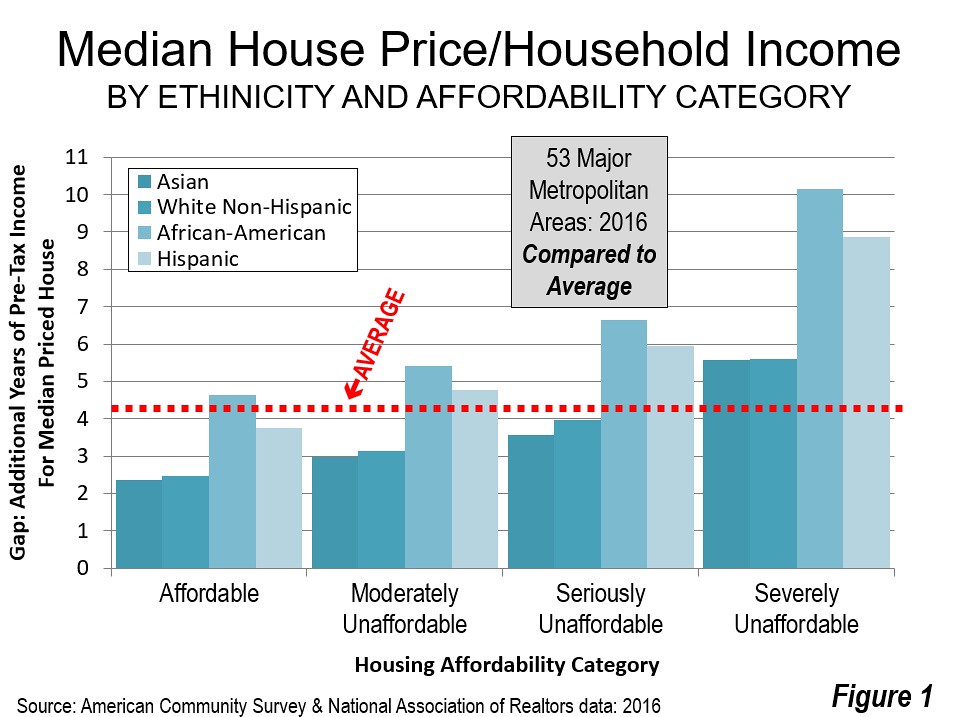
    Based on the housing affordability categories used in the Demographia International Housing Affordability Survey for 2016 (Table 1), housing inequality by ethnicity is the worst among the metropolitan areas rated “severely unaffordable.” In these 11 major metropolitan area markets, the most highly regulated, median multiples (median house price divided by median household income) exceed 5.0. For African-Americans, the median priced house is 10.2 times median incomes. This is 3.7 more years of additional income than the overall average in these severely unaffordable markets, where median house prices are 6.5 times median household incomes. It is only marginally better for Hispanics, with the median price house at 8.9 times median household incomes, 2.4 years more than the average in these markets (Figure 1).

    The comparisons with the 13 affordable markets (median multiples of 3.0 and less) is even more stark. For African-American households things are much better than in the more progressive and most expensive metropolitan areas. The median house prices is equal to 4.6 years of median income, 5.5 years less than in the severely affordable markets. Moreover, for African-Americans, housing affordability is only marginally worse than the national average in the affordable market.

    Things are even better for Hispanics, who would find the median house price 3.8 times median incomes, 5.1 years less than in the severely affordable markets. This is better than the national average housing affordability.

    Among the four markets rated “seriously unaffordable,” (median multiple from 4.1 to 5.0) the inequality is slightly less, with African-Americans finding median house prices equal to 2.2 years of additional income compared to average. The disadvantage for Hispanics is 1.5 years.

    In contrast, inequality is significantly reduced in the less costly “moderately unaffordable” markets (median multiple of 3.1 to 4.0) and the “affordable” markets (median multiple of 3.0 and less).

    The discussion below describes the 10 largest and smallest housing affordability gaps for African-American and Hispanic households relative to the average household, within the particular metropolitan markets. The gaps within ethnicities compared to the affordable markets would be even more. The four charts all have the same scale (a top housing affordability gap of 10 years) for easy comparison.

    able 2 illustrates housing affordability gaps by major metropolitan areas. There are also housing affordability ranking gap tables by African-American households (Table 3) and Hispanic households (Table 4).

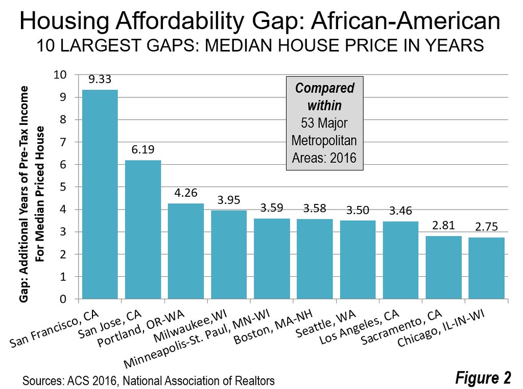
    Largest Housing Affordability Gaps: African American

    African-Americans have the largest housing affordability inequality gap. And these gaps are most evident in some of the nation’s most progressive cities. The largest gap is in San Francisco, where the median income African-American household faces median house prices that are 9.3 years of income more than the average. In nearby San Jose ranks the second worst, where the gap is 6.2 years. Overall, the San Francisco Bay Area suffers by far the area of least housing affordability for African-Americans compared to the average household.

    Portland, long the darling of the international urban planning community, ranks third worst, where the median income African-American household to purchase the median priced house. Milwaukee and Minneapolis – St. Paul ranked fourth and fifth worst followed by Boston, Seattle, Los Angeles, Sacramento and Chicago (Figure 2).

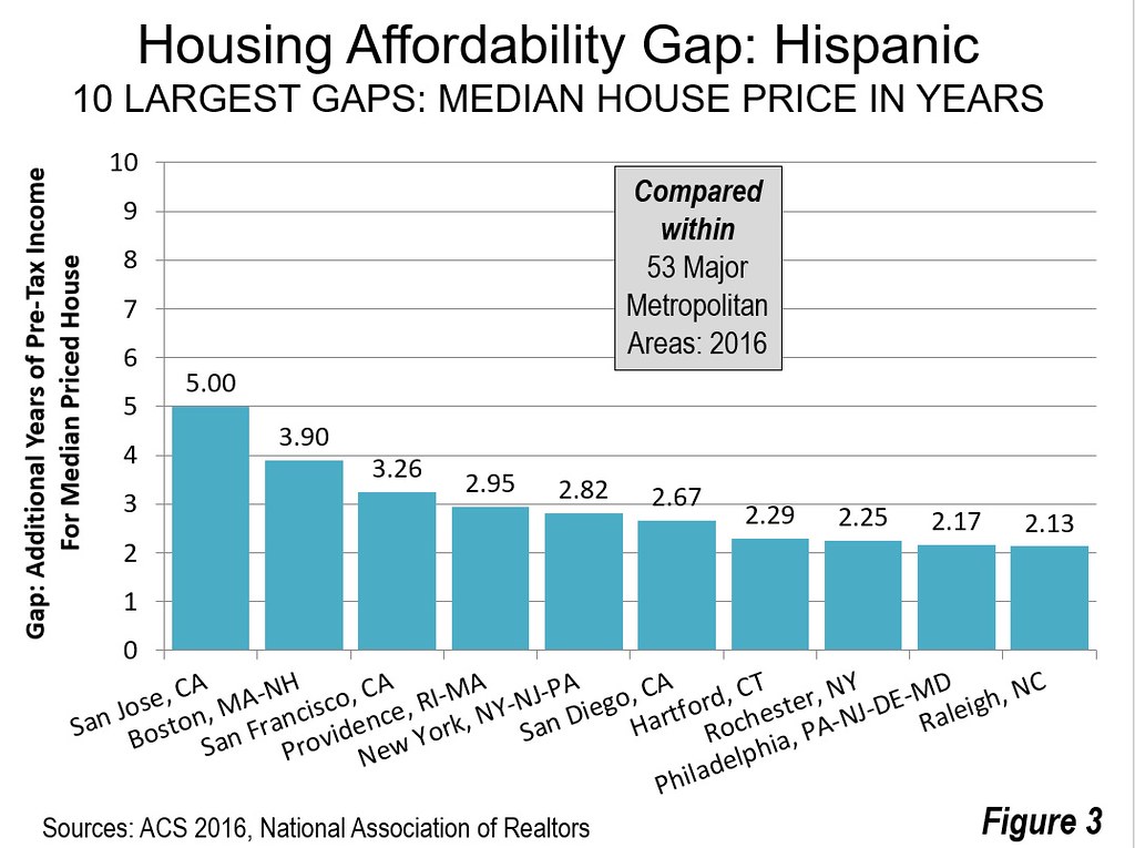
    Largest Housing Affordability Gaps: Hispanics

    Two of the three worst positions are occupied by the two metropolitan areas in the San Francisco Bay Area. The worst housing affordability gap for Hispanics is in San Jose, a more than one-quarter Hispanic metropolitan area where the median income Hispanic household would require 5.0 years of additional income to pay for the median priced house compared to the average. Boston ranks second worst at 3.9. San Francisco third worst at 3.3 years. Providence and New York rank fourth and fifth worst. The second five worst housing inequality for Hispanics is in San Diego, Hartford, Rochester, Philadelphia and Raleigh (Figure 3).

    The San Francisco Bay Area: “Inequality City”

    Perhaps no part of the country is more renowned for its progressive politics and politicians than the San Francisco Bay Area. Yet, in housing equality, the Bay Area is anything but progressive. If the African-American and Hispanic housing inequality measures are averaged, disadvantaged minorities face house prices that average approximately 6.25 years more years of median income in San Francisco and 5.60 more years of median income in San Jose.

    Moreover, no one should imagine that recent state law authorizing a $4 billion “affordable housing” bond election will have any significant impact. According to the Sacramento Bee, voter approval would lead to 70,000 new housing units annually, when the need for low and very low income households is 1.5 million. The bond issue would do virtually nothing for the many middle-income households who are struggling to pay the insanely high housing costs California’s regulatory nightmare has developed.

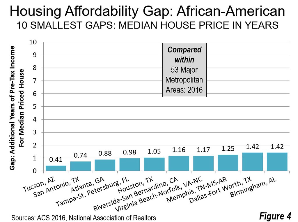
    Smallest Housing Affordability Gaps: African-American

    Tucson has the smallest housing affordability gap for African-Americans. In Tucson, the median income African-American household would pay approximately 0.4 years (four months) more in income for the median priced house than the average household. In San Antonio, Atlanta and Tampa – St. Petersburg, the housing affordability gaps are under 1.0. Houston, Riverside – San Bernardino, Virginia Beach – Norfolk, Memphis, Dallas – Fort Worth and Birmingham round out the second five. It may be surprising that eight of the metropolitan areas with the smallest housing affordability gaps for African-Americans are in the South and perhaps most surprisingly of all that one of the best, at number 10, is Birmingham. (Figure 4).

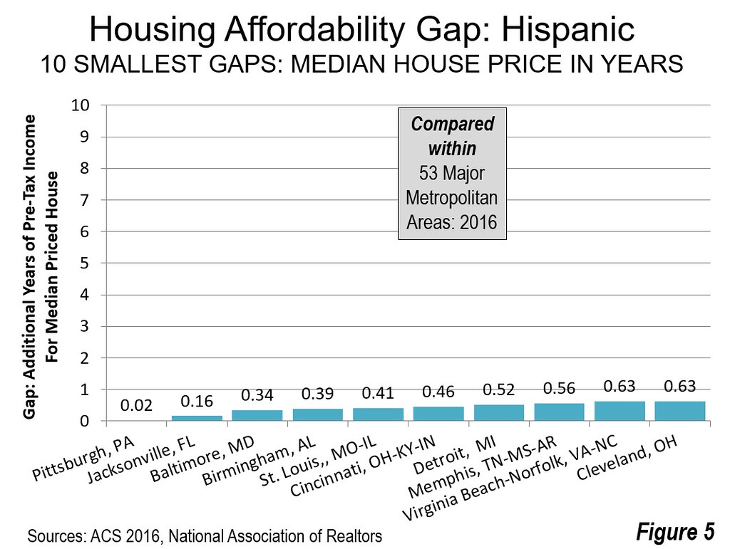
    Smallest Housing Affordability Gaps: Hispanic

    Among Hispanic households, the smallest housing affordability gap is in Pittsburgh, where the median priced house would require less than 10 days more in median income for a Hispanic household compared the overall average. In Jacksonville the housing affordability gap for Hispanics would be less than two months. In Baltimore, Birmingham, St. Louis and Cincinnati, the median house price is the equivalent of less than six months of median income for an Hispanic household. Detroit, Memphis, Virginia Beach – Norfolk and Cleveland round out the ten smallest housing affordability gaps for Hispanics (Figure 5).

    Housing Affordability is the Best for Asians

    Recent American Community Survey data indicated that Asians have median household incomes a quarter above those of White Non-– Hispanics. This advantage is also illustrated in the housing affordability data. Asians have better housing affordability than White Non-– Hispanics in 37 of the 53 major metropolitan areas (over 1 million population).

    The Importance of Housing Opportunity

    Housing opportunity is important. African-Americans and Hispanics already face challenges given their generally lower incomes. However, by no serious political philosophy, progressive or otherwise, should any ethnicity find themselves even further disadvantaged by political barriers, such as have been created by over-zealous land and housing regulators.

    Wendell Cox is principal of Demographia, an international public policy and demographics firm. He is a Senior Fellow of the Center for Opportunity Urbanism (US), Senior Fellow for Housing Affordability and Municipal Policy for the Frontier Centre for Public Policy (Canada), and a member of the Board of Advisors of the Center for Demographics and Policy at Chapman University (California). He is co-author of the “Demographia International Housing Affordability Survey” and author of “Demographia World Urban Areas” and “War on the Dream: How Anti-Sprawl Policy Threatens the Quality of Life.” He was appointed to three terms on the Los Angeles County Transportation Commission, where he served with the leading city and county leadership as the only non-elected member. He served as a visiting professor at the Conservatoire National des Arts et Metiers, a national university in Paris.

    Table 2
    Housing Affordability Gap by Ethnicity: 2016
    53 Major Metropolitan Areas (Over 1,000,000 Population)
    Median Multiple (Median house price divided by median household income)
    MSA Median Multiple: All Households Median Multiple: African-American African American Housing Affordability Gap in Years Ranked Most to Least Equal: African-American Median Multiple:
    Hispanic
    Hispanic Housing Affordability Gap in Years Ranked Most to Least Equal: Hispanic Exhibit: Median Multiple: Asian Exhibit: Median Multiple: White Non-Hispanic
       
     Atlanta, GA       2.95          3.83           0.88              3        3.65          0.70           13       2.30            2.45
     Austin, TX       4.00          5.69           1.69            19        5.04          1.04           24       3.23            3.52
     Baltimore, MD       3.29          4.75           1.46            12        3.64          0.34             3       2.60            2.83
     Birmingham, AL       3.57          4.99           1.42            10        3.96          0.39             4       2.95            3.02
     Boston, MA-NH       5.11          8.69           3.58            47        9.02          3.90           52       4.67            4.62
     Buffalo, NY       2.48          4.79           2.32            38        4.58          2.10           43       2.90            2.20
     Charlotte, NC-SC       3.47          4.95           1.47            13        4.77          1.30           32       2.31            3.08
     Chicago, IL-IN-WI       3.56          6.30           2.75            43        4.45          0.90           20       2.69            2.94
     Cincinnati, OH-KY-IN       2.53          4.70           2.17            35        2.99          0.46             6       1.75            2.33
     Cleveland, OH       2.54          4.50           1.96            27        3.17          0.63           10       1.49            2.16
     Columbus, OH       2.91          4.78           1.87            24        4.10          1.19           30       2.50            2.68
     Dallas-Fort Worth, TX       3.56          4.98           1.42              9        4.70          1.14           26       2.55            2.87
     Denver, CO       5.34          7.64           2.29            37        7.40          2.05           42       5.33            4.76
     Detroit,  MI       4.01          6.71           2.70            41        4.53          0.52             7       2.56            3.48
     Grand Rapids, MI       2.68          4.66           1.98            28        3.85          1.16           28       2.95            2.53
     Hartford, CT       3.18          4.88           1.70            20        5.48          2.29           47       2.78            2.82
     Houston, TX       3.52          4.57           1.05              5        4.68          1.15           27       2.54            2.65
     Indianapolis. IN       2.82          4.89           2.07            31        4.45          1.63           38       2.48            2.50
     Jacksonville, FL       3.71          5.15           1.43            11        3.88          0.16             2       3.32            3.38
     Kansas City, MO-KS       2.95          4.96           2.00            30        3.97          1.02           23       2.64            2.68
     Las Vegas, NV       4.37          6.36           1.98            29        5.19          0.82           16       3.63            3.85
     Los Angeles, CA       7.69        11.15           3.46            45        9.74          2.05           41       6.68            6.03
     Louisville, KY-IN       2.99          4.90           1.91            25        3.92          0.93           21       2.48            2.71
     Memphis, TN-MS-AR       3.12          4.37           1.25              8        3.68          0.56             8       2.13            2.29
     Miami, FL       5.94          7.58           1.64            17        6.64          0.70           12       4.39            4.68
     Milwaukee,WI       3.93          7.88           3.95            49        5.79          1.86           40       2.78            3.33
     Minneapolis-St. Paul, MN-WI       3.24          6.83           3.59            48        4.64          1.40           34       3.25            3.01
     Nashville, TN       3.74          5.43           1.69            18        5.04          1.30           33       3.12            3.43
     New Orleans. LA       3.85          6.42           2.57            40        5.02          1.17           29       4.01            2.93
     New York, NY-NJ-PA       5.40          7.85           2.45            39        8.22          2.82           49       4.68            4.25
     Oklahoma City, OK       2.74          4.81           2.07            32        3.62          0.88           19       2.52            2.45
     Orlando, FL       4.28          6.00           1.72            22        5.21          0.94           22       2.93            3.60
     Philadelphia, PA-NJ-DE-MD       3.42          5.69           2.28            36        5.59          2.17           45       3.02            2.82
     Phoenix, AZ       4.01          5.54           1.53            14        5.07          1.06           25       3.17            3.62
     Pittsburgh, PA       2.68          4.61           1.93            26        2.70          0.02             1       1.97            2.54
     Portland, OR-WA       5.11          9.38           4.26            50        6.69          1.57           37       4.44            4.89
     Providence, RI-MA       4.26          6.38           2.12            34        7.21          2.95           50       3.09            3.95
     Raleigh, NC       3.46          5.01           1.56            15        5.59          2.13           44       2.47            3.12
     Richmond, VA       3.74          5.44           1.70            21        4.61          0.87           18       2.75            3.14
     Riverside-San Bernardino, CA       5.38          6.55           1.16              6        6.04          0.66           11       4.04            4.85
     Rochester, NY       2.42          4.52           2.10            33        4.67          2.25           46       2.26            2.21
     Sacramento, CA       5.00          7.81           2.81            44        6.21          1.21           31       4.63            4.46
     St. Louis,, MO-IL       2.74          4.46           1.72            23        3.15          0.41             5       2.41            2.45
     Salt Lake City, UT       4.00  No data           5.49          1.49           36       3.70            3.77
     San Antonio, TX       3.69          4.43           0.74              2        4.41          0.72           15       2.89            2.86
     San Diego, CA       7.98        10.72           2.74            42      10.65          2.67           48       6.88            6.94
     San Francisco-Oakland, CA       8.67        18.01           9.33            52      11.93          3.26           51       7.96            7.29
     San Jose, CA       9.09        15.28           6.19            51      14.08          5.00           53       7.80            8.24
     Seattle, WA       5.27          8.77           3.50            46        7.02          1.74           39       4.55            5.00
     Tampa-St. Petersburg, FL       3.87          4.86           0.98              4        4.74          0.87           17       2.85            3.65
     Tucson, AZ       4.00          4.41           0.41              1        4.71          0.71           14       4.17            3.54
     Virginia Beach-Norfolk, VA-NC       3.48          4.65           1.17              7        4.11          0.63             9       2.94            3.00
     Washington, DC-VA-MD-WV       4.08          5.64           1.57            16        5.54          1.46           35       3.76            3.38
     Overall median multiple from Demographia International Housing Affordability Survey: Updated with revised income data from 2016 ACS. 
     Median multiple: Median house price divided by median household income 
    Table 3
    African-American Housing Affordability Gap Ranked: Most to Least Equal 
    53 Major Metropolitan Areas (Over 1,000,000 Population)
    Median Multiple (Median house price divided by median household income)
    MSA Median Multiple: All Households Median Multiple: African-American African American Housing Affordability Gap in Years Ranked Most to Least Equal: African-American Median Multiple:
    Hispanic
    Hispanic Housing Affordability Gap in Years Ranked Most to Least Equal: Hispanic Exhibit: Median Multiple: Asian Exhibit: Median Multiple: White Non-Hispanic
     
     Tucson, AZ       4.00          4.41           0.41              1        4.71          0.71           14       4.17            3.54
     San Antonio, TX       3.69          4.43           0.74              2        4.41          0.72           15       2.89            2.86
     Atlanta, GA       2.95          3.83           0.88              3        3.65          0.70           13       2.30            2.45
     Tampa-St. Petersburg, FL       3.87          4.86           0.98              4        4.74          0.87           17       2.85            3.65
     Houston, TX       3.52          4.57           1.05              5        4.68          1.15           27       2.54            2.65
     Riverside-San Bernardino, CA       5.38          6.55           1.16              6        6.04          0.66           11       4.04            4.85
     Virginia Beach-Norfolk, VA-NC       3.48          4.65           1.17              7        4.11          0.63             9       2.94            3.00
     Memphis, TN-MS-AR       3.12          4.37           1.25              8        3.68          0.56             8       2.13            2.29
     Dallas-Fort Worth, TX       3.56          4.98           1.42              9        4.70          1.14           26       2.55            2.87
     Birmingham, AL       3.57          4.99           1.42            10        3.96          0.39             4       2.95            3.02
     Jacksonville, FL       3.71          5.15           1.43            11        3.88          0.16             2       3.32            3.38
     Baltimore, MD       3.29          4.75           1.46            12        3.64          0.34             3       2.60            2.83
     Charlotte, NC-SC       3.47          4.95           1.47            13        4.77          1.30           32       2.31            3.08
     Phoenix, AZ       4.01          5.54           1.53            14        5.07          1.06           25       3.17            3.62
     Raleigh, NC       3.46          5.01           1.56            15        5.59          2.13           44       2.47            3.12
     Washington, DC-VA-MD-WV       4.08          5.64           1.57            16        5.54          1.46           35       3.76            3.38
     Miami, FL       5.94          7.58           1.64            17        6.64          0.70           12       4.39            4.68
     Nashville, TN       3.74          5.43           1.69            18        5.04          1.30           33       3.12            3.43
     Austin, TX       4.00          5.69           1.69            19        5.04          1.04           24       3.23            3.52
     Hartford, CT       3.18          4.88           1.70            20        5.48          2.29           47       2.78            2.82
     Richmond, VA       3.74          5.44           1.70            21        4.61          0.87           18       2.75            3.14
     Orlando, FL       4.28          6.00           1.72            22        5.21          0.94           22       2.93            3.60
     St. Louis,, MO-IL       2.74          4.46           1.72            23        3.15          0.41             5       2.41            2.45
     Columbus, OH       2.91          4.78           1.87            24        4.10          1.19           30       2.50            2.68
     Louisville, KY-IN       2.99          4.90           1.91            25        3.92          0.93           21       2.48            2.71
     Pittsburgh, PA       2.68          4.61           1.93            26        2.70          0.02             1       1.97            2.54
     Cleveland, OH       2.54          4.50           1.96            27        3.17          0.63           10       1.49            2.16
     Grand Rapids, MI       2.68          4.66           1.98            28        3.85          1.16           28       2.95            2.53
     Las Vegas, NV       4.37          6.36           1.98            29        5.19          0.82           16       3.63            3.85
     Kansas City, MO-KS       2.95          4.96           2.00            30        3.97          1.02           23       2.64            2.68
     Indianapolis. IN       2.82          4.89           2.07            31        4.45          1.63           38       2.48            2.50
     Oklahoma City, OK       2.74          4.81           2.07            32        3.62          0.88           19       2.52            2.45
     Rochester, NY       2.42          4.52           2.10            33        4.67          2.25           46       2.26            2.21
     Providence, RI-MA       4.26          6.38           2.12            34        7.21          2.95           50       3.09            3.95
     Cincinnati, OH-KY-IN       2.53          4.70           2.17            35        2.99          0.46             6       1.75            2.33
     Philadelphia, PA-NJ-DE-MD       3.42          5.69           2.28            36        5.59          2.17           45       3.02            2.82
     Denver, CO       5.34          7.64           2.29            37        7.40          2.05           42       5.33            4.76
     Buffalo, NY       2.48          4.79           2.32            38        4.58          2.10           43       2.90            2.20
     New York, NY-NJ-PA       5.40          7.85           2.45            39        8.22          2.82           49       4.68            4.25
     New Orleans. LA       3.85          6.42           2.57            40        5.02          1.17           29       4.01            2.93
     Detroit,  MI       4.01          6.71           2.70            41        4.53          0.52             7       2.56            3.48
     San Diego, CA       7.98        10.72           2.74            42      10.65          2.67           48       6.88            6.94
     Chicago, IL-IN-WI       3.56          6.30           2.75            43        4.45          0.90           20       2.69            2.94
     Sacramento, CA       5.00          7.81           2.81            44        6.21          1.21           31       4.63            4.46
     Los Angeles, CA       7.69        11.15           3.46            45        9.74          2.05           41       6.68            6.03
     Seattle, WA       5.27          8.77           3.50            46        7.02          1.74           39       4.55            5.00
     Boston, MA-NH       5.11          8.69           3.58            47        9.02          3.90           52       4.67            4.62
     Minneapolis-St. Paul, MN-WI       3.24          6.83           3.59            48        4.64          1.40           34       3.25            3.01
     Milwaukee,WI       3.93          7.88           3.95            49        5.79          1.86           40       2.78            3.33
     Portland, OR-WA       5.11          9.38           4.26            50        6.69          1.57           37       4.44            4.89
     San Jose, CA       9.09        15.28           6.19            51      14.08          5.00           53       7.80            8.24
     San Francisco-Oakland, CA       8.67        18.01           9.33            52      11.93          3.26           51       7.96            7.29
     Salt Lake City, UT       4.00  No data         5.49          1.49           36       3.70            3.77
     Overall median multiple from Demographia International Housing Affordability Survey: Updated with revised income data from 2016 ACS. 
     Median multiple: Median house price divided by median household income 
    Table 4
    Hispanic Housing Affordability Gap Ranked: Most to Least Equal 
    53 Major Metropolitan Areas (Over 1,000,000 Population)
    Median Multiple (Median house price divided by median household income)
    MSA Median Multiple: All Households Median Multiple: African-American African American Housing Affordability Gap in Years Ranked Most to Least Equal: African-American Median Multiple:
    Hispanic
    Hispanic Housing Affordability Gap in Years Ranked Most to Least Equal: Hispanic Exhibit: Median Multiple: Asian Exhibit: Median Multiple: White Non-Hispanic
       
     Pittsburgh, PA       2.68          4.61           1.93            26        2.70          0.02             1       1.97            2.54
     Jacksonville, FL       3.71          5.15           1.43            11        3.88          0.16             2       3.32            3.38
     Baltimore, MD       3.29          4.75           1.46            12        3.64          0.34             3       2.60            2.83
     Birmingham, AL       3.57          4.99           1.42            10        3.96          0.39             4       2.95            3.02
     St. Louis,, MO-IL       2.74          4.46           1.72            23        3.15          0.41             5       2.41            2.45
     Cincinnati, OH-KY-IN       2.53          4.70           2.17            35        2.99          0.46             6       1.75            2.33
     Detroit,  MI       4.01          6.71           2.70            41        4.53          0.52             7       2.56            3.48
     Memphis, TN-MS-AR       3.12          4.37           1.25              8        3.68          0.56             8       2.13            2.29
     Virginia Beach-Norfolk, VA-NC       3.48          4.65           1.17              7        4.11          0.63             9       2.94            3.00
     Cleveland, OH       2.54          4.50           1.96            27        3.17          0.63           10       1.49            2.16
     Riverside-San Bernardino, CA       5.38          6.55           1.16              6        6.04          0.66           11       4.04            4.85
     Miami, FL       5.94          7.58           1.64            17        6.64          0.70           12       4.39            4.68
     Atlanta, GA       2.95          3.83           0.88              3        3.65          0.70           13       2.30            2.45
     Tucson, AZ       4.00          4.41           0.41              1        4.71          0.71           14       4.17            3.54
     San Antonio, TX       3.69          4.43           0.74              2        4.41          0.72           15       2.89            2.86
     Las Vegas, NV       4.37          6.36           1.98            29        5.19          0.82           16       3.63            3.85
     Tampa-St. Petersburg, FL       3.87          4.86           0.98              4        4.74          0.87           17       2.85            3.65
     Richmond, VA       3.74          5.44           1.70            21        4.61          0.87           18       2.75            3.14
     Oklahoma City, OK       2.74          4.81           2.07            32        3.62          0.88           19       2.52            2.45
     Chicago, IL-IN-WI       3.56          6.30           2.75            43        4.45          0.90           20       2.69            2.94
     Louisville, KY-IN       2.99          4.90           1.91            25        3.92          0.93           21       2.48            2.71
     Orlando, FL       4.28          6.00           1.72            22        5.21          0.94           22       2.93            3.60
     Kansas City, MO-KS       2.95          4.96           2.00            30        3.97          1.02           23       2.64            2.68
     Austin, TX       4.00          5.69           1.69            19        5.04          1.04           24       3.23            3.52
     Phoenix, AZ       4.01          5.54           1.53            14        5.07          1.06           25       3.17            3.62
     Dallas-Fort Worth, TX       3.56          4.98           1.42              9        4.70          1.14           26       2.55            2.87
     Houston, TX       3.52          4.57           1.05              5        4.68          1.15           27       2.54            2.65
     Grand Rapids, MI       2.68          4.66           1.98            28        3.85          1.16           28       2.95            2.53
     New Orleans. LA       3.85          6.42           2.57            40        5.02          1.17           29       4.01            2.93
     Columbus, OH       2.91          4.78           1.87            24        4.10          1.19           30       2.50            2.68
     Sacramento, CA       5.00          7.81           2.81            44        6.21          1.21           31       4.63            4.46
     Charlotte, NC-SC       3.47          4.95           1.47            13        4.77          1.30           32       2.31            3.08
     Nashville, TN       3.74          5.43           1.69            18        5.04          1.30           33       3.12            3.43
     Minneapolis-St. Paul, MN-WI       3.24          6.83           3.59            48        4.64          1.40           34       3.25            3.01
     Washington, DC-VA-MD-WV       4.08          5.64           1.57            16        5.54          1.46           35       3.76            3.38
     Salt Lake City, UT       4.00  No data           5.49          1.49           36       3.70            3.77
     Portland, OR-WA       5.11          9.38           4.26            50        6.69          1.57           37       4.44            4.89
     Indianapolis. IN       2.82          4.89           2.07            31        4.45          1.63           38       2.48            2.50
     Seattle, WA       5.27          8.77           3.50            46        7.02          1.74           39       4.55            5.00
     Milwaukee,WI       3.93          7.88           3.95            49        5.79          1.86           40       2.78            3.33
     Los Angeles, CA       7.69        11.15           3.46            45        9.74          2.05           41       6.68            6.03
     Denver, CO       5.34          7.64           2.29            37        7.40          2.05           42       5.33            4.76
     Buffalo, NY       2.48          4.79           2.32            38        4.58          2.10           43       2.90            2.20
     Raleigh, NC       3.46          5.01           1.56            15        5.59          2.13           44       2.47            3.12
     Philadelphia, PA-NJ-DE-MD       3.42          5.69           2.28            36        5.59          2.17           45       3.02            2.82
     Rochester, NY       2.42          4.52           2.10            33        4.67          2.25           46       2.26            2.21
     Hartford, CT       3.18          4.88           1.70            20        5.48          2.29           47       2.78            2.82
     San Diego, CA       7.98        10.72           2.74            42      10.65          2.67           48       6.88            6.94
     New York, NY-NJ-PA       5.40          7.85           2.45            39        8.22          2.82           49       4.68            4.25
     Providence, RI-MA       4.26          6.38           2.12            34        7.21          2.95           50       3.09            3.95
     San Francisco-Oakland, CA       8.67        18.01           9.33            52      11.93          3.26           51       7.96            7.29
     Boston, MA-NH       5.11          8.69           3.58            47        9.02          3.90           52       4.67            4.62
     San Jose, CA       9.09        15.28           6.19            51      14.08          5.00           53       7.80            8.24
     
     Overall median multiple from Demographia International Housing Affordability Survey: Updated with revised income data from 2016 ACS. 
     Median multiple: Median house price divided by median household income 


    Photograph: San Francisco Bay Area: Where metropolitan housing opportunity is most unequal
    https://upload.wikimedia.org/wikipedia/commons/archive/d/dc/200609291846…

  • Oh, for those good days without fossil fuels!

    Maybe it’s time to start scaling back on our leisurely lifestyle to lower our greenhouse gas emissions and start reverting back to the pre-1900 horse and buggy days for our transportation systems, and the “snake oil” pitchmen for our healthcare system, and no medications, no cosmetics, no fertilizers, no computers nor IPhones, and shorter life spans. Our leisurely lifestyle has been driven by those “chemical ingredients” that are derived from the fossil fuels of oil, coal and natural gas that make all the “stuff” associated with our lifestyles, as they are NOT derived from nuclear electrical power, nor from intermittent electricity from solar panels and wind turbines.

    Looking back, the development of the internal combustion engine at the beginning of the 20th century, combined with the introduction of mass-produced affordable vehicles, got people moving on an unprecedented scale — and we haven’t looked back. Yes, it’s crude oil from which we have produced transportation fuels, but more importantly for civilization, it’s the related chemicals and by-products that have revolutionized our infrastructures and dramatically improved our quality of life and especially our leisurely lifestyle.

    The good news is that the chemicals and energy from fossil fuels have enabled us to cheaply build and run wondrous machines that give us the mobility to choose any particular climate and the ability to increase the livability of the climate, has made us safer and masters of climate from natural and man-made threats.

    The international aviation industry has been booming, with aviation fuel consumption more than double what it was 30 years ago in 1986. Worldwide, the consumption of jet fuels is astoundingly in excess of 225 MILLION gallons PER DAY to fly those huge aircrafts.

    Those huge cruise ships are consuming on average, 140-150 tons of fuel per day, which works out to roughly 30 to 50 gallons of fuel PER MILE !

    And by the way, it’s those two industries, the airlines and cruise ships, that were the catalyst to the hotel and theme park leisure industries that were not accessible in the horse and buggy times of our society.

    Complimentary to the international aviation and cruise industry are the billions of gallons of transportation fuels being consumed to get passengers back and forth from airports and the various ports, all in an effort to travel and see the beautiful cities and sites around the world, i.e., the tourism industry.

    The good news is that the fossil fuel industry has been the major contributor to industrialization, economic growth and the creation of jobs in all the infrastructure sectors and all the industries that are the basis of our lifestyle and economy, and technology continues to get ever better at minimizing and neutralizing the risks. The bad news is that we’re all getting older and sicker.

    Interestingly, a few side benefits associated with shorter life spans associated with those pre-1900 horse and buggy days would solve a few of our current financial problems:

    •   The unfunded liabilities of every city and state for those growing defined benefit retirement entitlement plans would be instantly solved by eliminating decades of retirement benefits per person.

    •   The single payer health care program to provide free health care for everyone may work be eliminating the exponential medical expenses associated with older folks.

    •   Social Security would never run out of funds by eliminating decades of payments per person.

    •   World population growth would be stagnated and relieve pressure on the world’s food supplies.

    Rather than reverting back to those good-old emission free days without fossil fuels when lives were dirty, smelly, difficult – and short, we should continue to efficiently utilize the elements from crude oil, coal, and natural gas that have provided all the “stuff” in our lifestyle, to improve the lifestyles of all those on this planet! In addition, we should also be augmenting electricity from intermittent renewables to operate all of our ”stuff” and gradually reduce the burning of our crude oil and coal.

    Ronald Stein is founder of PTS Staffing Solutions, a technical staffing agency headquartered in Irvine.

    Photo: Aero Icarus from Zürich, Switzerland (570dc) [CC BY-SA 2.0], via Wikimedia Commons

  • Case Studies in Autonomous Vehicles, Part I: Shared Use Vehicles and the Challenge of Multiple, Intermediate Stops

    There has been a lot of discussion about the potential of autonomous vehicles to change our transportation landscape, in particular the potential for such cars to be shared, reducing car ownership, parking needs and congestion on our roads. A principle idea behind this concept is that since autonomous vehicles can be driven from stop to stop without a driver, they will be cheaper and more mobile, prompting current car owners to switch to mobility as a service (MaaS) where rides are purchased on an as needed basis.

    A recent report by the consulting firm McKinsey & Company notes that although ridesharing services are growing, they still represent only about one percent of the vehicles miles traveled in the United States each year. The development of autonomous vehicles by itself is unlikely to radically change this statistic. Why not? Viewed from the perspective of the consumer-passenger, the fact that autonomous vehicles can pick up passengers all day without a driver does not in itself present a compelling reason for a person to switch from ownership to sharing. Rather, a number of other considerations, including convenience, safety, speed, and overall cost, likely will shape consumer decisions about whether to own or share. So while autonomous vehicles may be a necessary condition for widespread ride sharing, they are not sufficient. In other words, automation alone will not be enough.

    Viewed from this lens, we need to think about how to design autonomous vehicles and our urban landscape to encourage MaaS (even if this consists only of single passenger rides in one “shared” vehicle). In so doing, we should acknowledge that sharing will not just happen. Rather, the experience of sharing vehicles and/or rides must be equal to or more compelling than owning in terms of convenience, reliability, cost and other factors.

    The Challenge of Multiple, Intermediate Stops

    One of the biggest challenges to shared use of autonomous vehicles lies in the need for individuals to make multiple, intermediate stops during the course of their trip and store goods along the way. A few examples are helpful to consider:

    Example 1 – Family Beach Day

    A family goes to the beach for the day, stopping first by car at the convenience store for 15 minutes to pick up some sunscreen and some snacks. They throw these items into their trunk and then go to the beach. When they arrive at the beach, they need a place to store their personal belongings such as keys, etc. so they hide them in their vehicle. When they are ready to head back home, they put their used beach towels and other equipment back in their trunk and ride home. Since they are making multiple stops and need to store belongings both during the interim stop and at their destination, the family may choose to drive their own car rather than using a ride hailing service. Also, they don’t want to be dropped off at their initial stop at the convenience store, have to wait a second time to get picked up to go to the beach, and then a third time to return home, incurring charges for each ride.

    Example 2 – Shopping Excursion

    A couple wants to visit three shops in three different neighborhoods. Like our beach going family, they may need to store any goods they purchase during the course of their journey. This could lead them to drive themselves rather than use a ride hailing service. Also, if they use a ride-hailing service, they will have to pay for three sets of rides. Autonomous vehicles may make these rides less expensive but they will not necessarily solve the logistical considerations.

    Multiple, intermediate stops raise two significant challenges for shared use vehicles: (1) the challenge of where passengers store belongings during multiple, intermediate stops; and (2) ride-hailing services become more expensive for passengers who need to pay for multiple-destination rides.

    Most individuals at some point need to make multiple, intermediate stops and to store possessions along the way. If such individuals have such needs even a handful of times, there may be a compelling case for them to continue owning a vehicle rather than using shared car services. To encourage ride sharing will require some creative thinking about how to structure this service and accommodate shifting logistical and storage needs. This might include new forms of personal and urban storage or amenities included in shared vehicles that make it easier to handle multiple stops. The key point is that automation alone will not solve all our problems. Rather, we will need to “work on it” just like most other endeavors.

    Conclusion

    Much has been said about the potential for autonomous vehicles to drive MaaS and convert vehicle owners to purchasers of trips on an as-needed basis. There is exciting potential in this idea and one that could transform our landscape in a positive manner. However, such thinking sometimes ignores the need for multiple, intermediate stops, and the accompanying “dwell” time that comes with them. These types of trips present a significant challenge to utilization of shared use vehicles. Ride hailing companies and anyone with an interest in expanding the market for MaaS should carefully think through exactly how trips can be engineered so as to make them equivalent or superior to the experience of owning a vehicle.

    Blair Schlecter is based in Los Angeles and writes about transportation policy and innovation. He can be reached at schlecterblair@gmail.com.

    Photo: Flckr user jurvetson (Steve Jurvetson). Trimmed and retouched with PS9 by Mariordo [CC BY-SA 2.0], via Wikimedia Commons

  • Local Empowerment Should Be About Local Matters

    I’ve generally been someone who wants to see local governments have more power and flexibility to meet local needs. My rationale is simple. States are full of diverse communities that are a bad fit for one size fits all policies. Chicago, Danville, Peoria, Cairo, etc. are radically different places. They have different circumstances, needs, and local priorities. Hence it makes sense for them to have the ability to chart their own course to some degree. Some states have accommodated this to some extent through classes of cities with different powers based on size. Others give even more flexibility through home rule or individualized city charters.

    A good example of responding to local needs was Austin’s regulation of Uber. They were responding to specific local complaints about sexual assault by Uber drivers. And they put in place regulatory requirements including fingerprint background checks directly targeted at this problem.

    Similarly Oklahoma City used its sales tax powers to put forth a series of referendums to approve temporary tax hikes to fund capital improvements like parks, sidewalks, and school renovations. (This was their Metropolitan Area Projects (MAPS) initiative).

    Today though we are seeing cities abuse their local authority. Rather than using them for bona fide local matters, they are deploying them to politically grandstand and/or affect federal or state policy.

    For example, we hear about cities and mayors being the locus of the “Resistance” to Trump. We also see explicit strategies like the “Fight for $15” minimum wage effort that is attempting to create a new national minimum wage through bottoms up change at the local level. Note at the $15/hr minimum wage has little to do with local economic conditions, but is the target in all kinds of places. It may well be that people can’t get the full $15/hr through, but it’s being promoted as the new base.

    Regardless of the merits or lack thereof of any of these items, when cities explicitly state their desire to, for example, subvert US foreign policy, this weakens the case against state preemption laws and for local empowerment generally. When local leaders get outside the areas where they are clearly chartered to do business (infrastructure, education, sanitation, etc) and get into areas traditionally more heavy on state or federal rulemaking and not nearly so obvious a local function (economic regulation, climate policy, etc), don’t be surprised when the other levels of government who see themselves running the show in those matters swoop in and drop the hammer.

    Obviously, this won’t necessarily protect you. Austin was not trying to tell the state or national government or any other city how to regulate Uber. The Texas legislature, wrongly in my view, override their ordinance anyway. But it’s still not a good idea to gratuitously invite trouble.

    Mayors do not in fact rule the world. In the US, municipalities are structurally weak entities in most cases. We can debate all day long whether things should be different, but at this point that’s reality. To earn the right to go to legislatures to get more authority, or even to just keep the authority that they have, cities should be good stewards of that authority and use it for matters and reasons they make very clear are local, not national or state in scope.

    This piece originally appeared on Urbanophile.

    Aaron M. Renn is a senior fellow at the Manhattan Institute, a contributing editor of City Journal, and an economic development columnist for Governing magazine. He focuses on ways to help America’s cities thrive in an ever more complex, competitive, globalized, and diverse twenty-first century. During Renn’s 15-year career in management and technology consulting, he was a partner at Accenture and held several technology strategy roles and directed multimillion-dollar global technology implementations. He has contributed to The Guardian, Forbes.com, and numerous other publications. Renn holds a B.S. from Indiana University, where he coauthored an early social-networking platform in 1991.

    Photo: w:en:User:Soonerfever [Public domain], via Wikimedia Commons

  • Bringing Soviet Planning to New York City

    New York City Mayor Bill de Blasio wants to bring the same policies that worked so well in the Soviet Union, and more recently in Venezuela, to New York City. “If I had my druthers, the city government would determine every single plot of land, how development would proceed,” he says. “And there would be very stringent requirements around income levels and rents.”

    As shown in the urban planning classic, The Ideal Communist City, soviet planners also believed they were smart enough to know how every single plot of land in their cities should be used. The cities built on their planning principles were appallingly ugly and unlivable. They were environmentally sustainable only so long as communism kept people too poor to afford cars and larger homes.

    If de Blasio believes in this planning system so much, why doesn’t he implement it in New York City? The biggest obstacle, he says, is “the way our legal system is structured to favor private property.” He blames housing affordability problems on greedy developers who only build for millionaires.

    The reality is that, under the control of private property owners, New York City housing was quite affordable in 1969. It was only when planners began to interfere with private property rights that housing prices spiraled out of control.

    In 1969, New York City median family incomes were $,9692 and median home prices were $25,700, for a value-to-income ratio of 2.7. This was affordable because, at 5 percent interest, someone could devote 25 percent of their income to a mortgage that is 2.7 times their income and pay off the loan in 15 years. Housing was even more affordable in the suburbs, as value-to-income ratios in the New York metropolitan area were 2.6.

    By comparison, value-to-income ratios in 2015 were 8.8 for the city and 5.1 for the metropolitan area. Even at today’s 3 percent interest rates, someone buying a home that is 8.8 times their income could devote a third of their income to the mortgage and not be able to pay it off in 40 years.

    What happened since 1969 to make housing so much less affordable? Contrary to de Blasio, one thing that didn’t happen is that developers got greedier. While there is no accurate measure, I am sure that people were just as greedy in 1969 as they are today. The human desire to accumulate wealth hasn’t changed in thousands of years, which is one reason why the kind of socialism that de Blasio favors never works.

    Instead, one thing that happened was rent control. New York state first imposed rent control in 1950, but the law exempted rental housing built after 1947, and other housing was gradually deregulated through 1969. But in 1969, New York passed a new law that applied rent control to all housing, thus discouraging anyone from building new rental housing.

    Another thing that happened was the city’s historic preservation ordinance, which was passed in 1965 and which has gradually restricted more and more of the city from redevelopment. More recently, New York City responded to unaffordable housing by passing an inclusionary zoning ordinance which provides affordable housing for a tiny number of people at the expense of making it less affordable for everyone else.

    New Jersey and Connecticut did their part by passing statewide growth management laws, thus restricting people’s ability to escape New York City’s high housing prices by moving to the suburbs. Connecticut first passed its law in 1974 and New Jersey in 1986.

    All of these actions are examples of the kind of government control that de Blasio supports, and all of them contributed to the high housing costs that de Blasio objects to. The next time he wants to find a greedy person to blame for unaffordable housing, he should look in a mirror.

    This piece first appeared on The Antiplanner.

    Randal O’Toole is a senior fellow with the Cato Institute specializing in land use and transportation policy. He has written several books demonstrating the futility of government planning. Prior to working for Cato, he taught environmental economics at Yale, UC Berkeley, and Utah State University.

    Photo: Kevin Case from Bronx, NY, USA (Bill de Blasio) [CC BY 2.0], via Wikimedia Commons

  • The Bottom Line of the Culture Wars

    America’s seemingly unceasing culture wars are not good for business, particularly for a region like Southern California. As we see Hollywood movie stars, professional athletes and the mainstream media types line up along uniform ideological lines, a substantial portion of the American ticket and TV watching population are turning them off, sometimes taking hundreds of millions of dollars from the bottom line.

    This payback being dealt out to urbane culture-meisters by the “deplorables” are evidenced by historically poor ratings for such hyper-politicized events as the Oscars last year as well as this year’s Emmys. The current controversy surrounds the NFL player protests, which are lowering already weak ratings, down 10 percent since the national anthem protests, as well as plunging movie ticket sales. The oddly political sports network ESPN has seen declines close to catastrophic, although how much their often strident “resistance” turns off viewers is widely debated.

    Jettisoning your audience

    Historically, the genius of American entertainment, particularly Hollywood, lay in the appeal to the everyman. American movie stars, whatever their background, were Anglicized and could, at very least, “pass” for northern Europeans. In recent decades, the definition of “everymen” thankfully expanded, albeit imperfectly, to African Americans, Hispanics, Asians, Jews, Muslims and gays.

    In the process, Hollywood and sports managed to expand their market by appealing to an ever more diverse consumer base both here and abroad. But with the rampant politicization of culture, sports and information, the notion of a common cultural market has all but disappeared.

    Among those in control of mainstream media culture — newspapers, magazines, movie studios and television networks — attention is focused on an affluent, progressive audience concentrated in urban centers. The ignored, or disdained, are not just the roughly 46 percent of voters who voted for Donald Trump, but a wider section of middle-class America.

    Read the entire piece at The Orange County Register.

    Joel Kotkin is executive editor of NewGeography.com. He is the Roger Hobbs Distinguished Fellow in Urban Studies at Chapman University and executive director of the Houston-based Center for Opportunity Urbanism. His newest book is The Human City: Urbanism for the rest of us. He is also author of The New Class ConflictThe City: A Global History, and The Next Hundred Million: America in 2050. He lives in Orange County, CA.

    Photo: BDS2006 [CC BY-SA 3.0 or GFDL], via Wikimedia Commons