Blog

  • The Beijing Bicycle: A Requiem

    Just because China has 500 million bikes on the road or tucked away in sheds or courtyards does not mean the two-wheeler has a bright future there, especially in its largest cities.

    Such is the growing indifference to the bike in China that no one seems to mind that the national model is manufactured in Taiwan (or under license on the mainland). With a single gear and heavy steel frame, the Giant is ideal for long rides on flat city streets. At a cost of US $180, it is the bike bargain of the world. Nevertheless, the dream for younger Chinese is a Honda scooter.

    The problem now in Beijing, Xian, and Guangzhou, if not in the country at large, is that increased prosperity is making city bike riding that much more a thing of the past. Wonderful Asian bike cities like Hanoi have already been lost to the noisy scooter and small car. Is Beijing next?

    Three years ago, Beijing was delightful by bike. Initially, I signed up with my friend George at Bicycle Kingdom to teach me the tricks of the narrow streets and the detours around Tiananmen Square. Ever since that first night of instruction, when we rolled out to the Olympic Park and down to the Temple of Heaven, I have been pedaling on my own power in Beijing and savoring every moment in the saddle.

    One reason that biking in Beijing is such a pleasure is that riders are accorded privileges lost to those sitting in traffic jams or drifting around on tour buses. During the 60th anniversary of the Chinese Revolution, a bike got me a front row seat to the spectacle.

    Beijing bikes have their own lanes, traffic lights, and rights-of-way, and a rider can easily thread his or her way anywhere. At railroad stations there are special bicycle parking lots, and even at the Forbidden City it is possible to leave your bike next to the front gate, as if you were a Mandarin.

    A few of the parks are off-limits to riders, but to my mind the only way to explore the hutongs — the historic districts of old Beijing, laid out like rabbit warrens — is on a bike, with which it is possible to roll past tea houses, food stalls, and open shops, as if in a Venetian gondola.

    Recently back in the capital, I spent a long day riding from Tiananmen Square out to Peking University, near the Summer Palace — about fifteen kilometers (a little more than nine miles) to the northwest.

    I had mapped out my route using a mixture of back streets and boulevards, and rolled away to find the Beijing grave site of the American writer Edgar Snow, whose 1937 book, Red Star Over China, was the first English-language account of Mao Tse-tung and a reportorial classic. (They met near Yenan, to which I went by train, but where there are almost no bikes.)

    To be sure, bike riding in Beijing is an acquired skill. I accept that it means weaving around buses, parked cars, delivery vans, and other obstacles. What surprised me on this long ride — about three hours in all — is how often the bikes lanes were flooded with motor scooters, cars, and a variety of motorized contraptions.

    After a while, I had my eyes attuned to the demographics of bike riders. They tended to be school kids or the elderly. From this blacktop survey, I judged that middle-aged or prosperous Beijingers have little appetite for riding. Most were moving around on scooters, the kind that have clogged many Asian cities.

    On earlier bike rides around Beijing, I found the experience sublime. This time it felt like I was riding for my life in New York City, outnumbered and outgunned by a variety of taxis, swerving motorists, and motorcyclists.

    Not only is Beijing going the way of Bangkok and other Asian cities that have been lost to gridlock, but the effects of non-riding can been seen among the Chinese themselves, more of whom are obese; undoubtedly KFC and McDonalds don’t help, either.

    Beijing is not the only Chinese city where I found biking on the wane. On my recent trip I also visited Xian, Chongqing, and Guangzhou, in search of Maoist redoubts and World War II battlefields. Chongqing (which has an excellent General Joseph Stilwell Museum and a Chou En-lai house) is built on hills, like San Francisco, so it has never been much of a bike city. Xian and Guangzhou are ideal for the bike, at least in their historic quarters. Yet each city is now overrun with cars.

    In Xian, I spent a long time just trying to find a shop that would rent me a bike. I went to several where the owners just shrugged. Finally, I borrowed a neglected bike from a hostel, but first had to take it in for repairs. No one had ridden this Giant in weeks, and the seat was set for a Lilliputian.

    You wouldn’t cycle to see the Terra Cotta warriors on a local clunker, as they are an hour by car from the city. But a bike is perfect to explore the Muslim quarter or to take in the Xian Incident Museum, which tells the story of Chiang Kai-shek’s kidnapping in 1936 and his subsequent agreement to recognize the Communist party. (Nothing focuses the mind like a kidnapping.) In Guangzhou I made it to the Sun Yat-sen Museum, but the snarling traffic scared me into a taxi.


    In Beijing and other cities, you still see bicycles loaded with garbage bags, cords of wood, furniture, dumplings, racks of clothing, and things like hundreds of fresh eggs. Some riders can comfortably bike around several family members on one frame, and it’s not unusual to see children following a parent through a busy intersection. In one alley, I biked alongside a man using his bike to move a large desk.

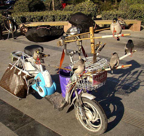
    In Beijing and Xian, I especially love the cyclists who have rigged up devices so that they can ride around with their caged birds, although one cycling raven of my acquaintance just sat on a wooden perch across the handlebars. Where will he be in five or ten years? I hate to think that Edgar Allen Poe was a writing an elegy for, among other things, the Beijing bike:

    Quoth the raven, “Nevermore.”

    Matthew Stevenson, a contributing editor of Harper’s Magazine, is the author of Remembering the Twentieth Century Limited, a collection of historical travel essays. His next book is Whistle-Stopping America.

    Photo: Raven on a Bicycle, Beijing, by the author.
    Flickr Photo: Bird Scooter; birds and paraphernalia on a bike in Beijing by IstoletheTV.

  • Will Servants’ Quarters Come Back, Too?

    As the Great Recession enters its fourth summer, America continues to separate into the multiple economic strands that characterized an earlier day. Our cities, built mostly since the 1930s, poorly accommodate this lack of unity, and will require radical revision if our class divisions continue to deepen.

    Back in the era of the streetcar suburbs, at the turn of the 20th century, we also experienced a tiered, multiple economy. The post-Victorian prosperous middle class had carved itself new residential beltways around inner core cities – the so-called “suburbs”. The look and the form of these old residential beltways is fondly remembered by some, so much so that they are imitated in some new developments today. Tall houses tight to the street with service alleys and front porches marked America’s urban form in this era, and can be seen in much of the literature promoting traditional town planning.

    Examining the original homes more closely yields some surprises, for they were radically different than our homes of today. The differences aren’t apparent from the outside, which is perhaps not important to the planners who wish to reinstitute this kind of design. Turn-of-the-century houses accommodated two economies by dedicating the first two floors to the middle-class family who owned the home (usually white), while the attic or basement had a separate entry and stair to the kitchen, dedicated to the staff (usually from an immigrant or ethnic minority group).

    This two-tiered economy was considered natural and acceptable at the time. Domestic labor was an inexpensive and ingrained part of the American middle class experience. The staff often came and went via the service alleys, and the streetcars were often built to connect the housekeepers, butlers, and cooks to the city, while father commuted into town on his own.

    Cities were also two-tiered, with bands of low-income service housing interwoven between more prosperous neighborhoods. Winter Park, Florida, where I live and work, is a good example of this. Tony Park Avenue is a shopping street that runs north-south through the city beside a pretty chain of lakes. Surrounding those lakes are houses built as second homes for wealthy families from Chicago and elsewhere in the Midwest.

    On the west side of Park Avenue, within a short walk of those homes, sits one of those bands: Hannibal Square, a neighborhood where many of the domestic service workers lived. Tiny homes on 25 foot lots still exist, sandwiched together, out of sight of the promenading Winter Park set across the railroad tracks. This city form was repeated with many variations throughout the South. The word “segregation” comes closest to identifying this double economy, with all the inequality that it implies.

    In Winter Park’s post-World War II era, as Florida boomed, many of the grand old bungalows with attic apartments emptied out, and were sold to owners looking for permanent, year-round residences. This new generation used these structures differently. A combination of upward mobility, opportunity, and a new sense of unity in the decade of conformity made it unfashionable to have servants in one’s own home. By 1954, separate but equal was banished forever in schools. Housing was undergoing a similar evolution. Throughout the 1960s the two-tiered home was phased out, and many thought staff quarters and the upstairs-downstairs subculture was gone forever.

    Economic pressure, meanwhile, on neighborhoods like Hannibal Square became fierce. Original residents, now retired, saw their home values appreciate. A few sold out – much to the chagrin of their children, who felt a neighborhood allegiance and resented the gentrification and loss of identity of their community. Cities like St. Petersburg, Florida, that have a similar geography to Winter Park, are still experiencing severe strains in race relations as they cope with this dark vestige of a two-tiered economy.

    Yet by the turn of this century our housing forms had shown measurable progress indeed. Segregated staff quarters were largely things of the past. Suburban residents, whether from Hannibal Square or upper Winter Park, were competing in the same large job marketplace, freed from the caste system of servant and served.

    Nostalgia for the urban form that flourished in a two-tiered economy stems from a romantic notion about the simplicity of these times, and, at least for the prosperous, life certainly was simple. But adapting the architecture of 1905 to the residential market of the start of this century has been a selective process.

    Shady, narrow streets, white picket fences, and front porches where neighbors could sit and wave to passers-by are trademarks of yesteryear which developers — and buyers — wanted to see replicated. Where servant’s quarters used to be, interior square footage was regained for home theaters, home gyms, game rooms, play rooms, and family rooms, now that a domestic servant was not required. These rooms respond to our contemporary culture’s increasingly private, plugged-in world, but are at odds with the outward urban form that emulates an “eyes on the street” culture swept away by the car. Home prices skyrocketed partly because buyers were demanding the interior amenities that they craved, as well as exterior amenities that they were being taught to appreciate.

    Meanwhile, our economy was dis-unifying into strands that economist Paul Krugman so aptly nicknamed The Great Unraveling. We thought we were progressing, but it is a bitter truth that the world can, after all, regress.

    Should this multi-tiered economy harden into a physical form, it could likely resemble that of the previous century, a form that we thought we had put away for good. It would be sadly ironic if neo-traditional neighborhoods, created to resemble the forms of the old two-tiered economy, are to now be remodeled to accommodate the “new” two-tiered economy.

    Richard Reep is an architect and artist who lives in Winter Park, Florida. His practice has centered around hospitality-driven mixed use, and he has contributed in various capacities to urban mixed-use projects, both nationally and internationally, for the last 25 years.

    Flickr Photo by Bob Carney. Neo-traditional homes – large homes on very small lots in Urbana, Maryland

  • A Better Plan to Save the Astrodome

    Setting aside my own wishes for the Astrodome, and just looking at the plan recently presented by the HCSCC to Commissioners Court, there is a very simple fix that will make saving the Astrodome *much* more likely.

    Current Plan

    • $270m to convert Astrodome into multi-purpose venue
    • $385m to demolish and rebuild a new Astrohall/Reliant Arena

    Net cost estimated to be $523m after tax credits.

    MAJOR PROBLEM = getting voters to approve a half-billion dollar bond issue (!)

    Better Plan

    Tear down an obsolete Reliant Arena and fold whatever functions a new one would have into a renovated Astrodome.  It’s not like the Astrodome doesn’t have enough space.  Heck, it could probably do just about everything they wanted to do in it originally and still have room for everything they want to do in a new Arena.  We lose a building nobody cares about and preserve a building everybody wants to save at probably less than half the price of the current proposal (something voters might actually approve).

    A big win-win, yes?  If you agree, please contact your County Commissioner asap and let them know.  They’re meeting to make some decisions on this plan very soon – possibly this week.

    This post originally appeared at Houston Strategies.

  • Rio-20: Eradicating Poverty Takes Precedence Over “Green Economy”

    The world’s largest English language newspaper, The Times of India reports that the Rio 20 Summit has agreed with India that "eradicating poverty should be given the highest priority, overriding all other concerns to achieve sustainable development." 

    The Times continued: "After a bitter fight with the developed countries, who wanted the objective of poverty eradication be made subservient to creating a ‘green economy’, India’s demand to put the goal of removing poverty above all other objectives in the final Rio+20 declaration — called "The Future We Want" — was agreed to…"

    The "G77" group of developing nations sought to ensure that economic and social sustainable developed goals were not secondary to "more green themes — such as renewable energy targets." The United States is reported to have supported the G77 position.

  • Thunder On The Great Plains: A Written-Off Region Enjoys Revival

    They may not win their first championship against Miami’s evil empire, but the Oklahoma City Thunder have helped to put a spotlight on what may well be the most surprising success story of 21st century America: the revival of the Great Plains. Once widely dismissed as the ultimate in flyover country, the Plains states have outperformed the national average for the past decade by virtually every key measure of vitality — from population, income and GDP growth to unemployment — and show no sign of slowing down.

    It’s a historic turnaround. For decades, the East Coast media has portrayed the vast region between Texas and the Dakotas as a desiccated landscape of emptying towns, meth labs and right-wing “clingers.” Just five years ago, The New York Times described the Plains as “not far from forsaken.”

    Many in the media and academia embraced Deborah and Frank Popper’s notion that the whole region should be abandoned for “a Buffalo commons.” The Great Plains, the East Coast academics concluded, represents “the largest, longest-running agricultural and environmental miscalculation in American history” and boldly predicted the area would “become almost totally depopulated.”

    Yet a funny thing happened on the way to oblivion. Rising commodity prices, the tapping of shale gas and oil formations and an unheralded shift of industry and people into the interior has propelled the Plains economy through the Great Recession.

    Since 2000, the Plains’ population has grown 14%, well above the national rate of 9%. This has been driven by migration from the coasts, particularly Southern California, to the region’s cities and towns. Contrary to perceptions of the area as a wind-swept old-age home, demographer Ali Modarres has found that the vast majority of the newcomers are between 20 and 35.

    Oklahoma City epitomizes these trends. Over the last decade, the city’s population expanded 14%, roughly three times as fast as the San Francisco area and more than four times the rate of growth of New York or Los Angeles. Between 2010 and 2011 OKC ranked 10th out of the nation’s 51 largest metropolitan areas in terms of rate of net growth.

    Nothing more reflects the changing fortunes of Oklahoma City than the strong net migration from many coastal communities, notably Los Angeles and Riverside, a historic reversal of the great “Okie” migration of the 1920s and 1930s. In the past decade, over 20,000 more Californians have migrated to Oklahoma than the other way around. OKC has even experienced a small net migration from the Heat’s South Florida stomping grounds.

    The city’s transformation from a cow town into an attractive, modern metropolis has been fueled by some $2 billion in public investment and over $5 billion in private investment, says Roy Williams, president of the Oklahoma City Chamber of Commerce. Besides the arena for the Thunder, the city has engineered a successful riverfront development known as Bricktown, fostered a growing arts scene and become more ethnically diverse, largely as a result of immigration from Mexico.

    This pattern of revived urbanization can be seen in other Plains cities. World-class art museums grace Ft. Worth’s Cultural District, and downtown in Omaha, Neb., has become a lively venue bristling with revelers on weekends. Even downtown Fargo, N.D., now boasts a boutique hotel, youth-oriented bars, interesting restaurants and a small, but vibrant arts scene.

    Great Plains cities are doing well, however, predominantly due to their strong record of economic growth. Over a decade in which most large metropolitan areas lost jobs, Ft. Worth, Dallas, Oklahoma City and Omaha have created employment. Unlike many Bush-era boom towns, such as Las Vegas, Riverside-San Bernardino, Calif., or the major Florida cities, the Plains did not hemorrhage jobs during the Great Recession.

    The Plains states enjoy some of the lowest unemployment rates in the country. There were seven states with unemployment of 5% or less in April; four are on the Plains: North Dakota, with the nation’s lowest jobless rate at 3%, South Dakota, Nebraska, Iowa and Oklahoma.

    This is partly due to a booming energy industry. As U.S. oil and gas production has surged over the past decade, the Plains’ share has grown from roughly a third to nearly 45%. The biggest two gainers, Texas and Oklahoma, together boosted their energy employment by 220,000.

    But the Great Plains’ economic dynamism extends well beyond energy. The region’s farms and ranches cover an area exceeding 500 million acres,or over 790,000 square miles — larger than Mexico — and account for roughly a quarter of the nation’s agricultural production. These farms have benefited from the long-term increase in food commodity prices — notably wheat, corn, soybeans — and record exports. Since 2007 the Plains share of food shipments abroad has surged from 20% to nearly 25%.

    At the same time, the region’s industrial sector, notes research by Praxis Strategy Group’s Mark Schill, has withstood the recession better than the rest of the nation. Never a center of unionized mass manufacturing, the region has become a location of choice for expanding industries, in part due to low costs, cheap energy and a favorable regulatory environment.

    They know all about this in Oklahoma . Last year the Sooner State led the nation in industrial growth. One major coup: a large Boeing facility moved last year from California to OKC. The Dakotas and Nebraska also sit in the top ranks of producers of new industrial jobs. Since 2007, the Plains states have boosted their share of U.S. manufactured good from 19% to 21%.

    More surprising still has been the region’s surge in employment in jobs related to science, technology, engineering and math. This has been spearheaded, of course, by Texas, but most other Plains states — North Dakota, South Dakota, Oklahoma — also have enjoyed well above average tech job growth. North Dakota, remarkably, now boasts the second-highest percentage of people 25 to 44 with a post-secondary education, behind only Massachusetts; it also has one of the highest rates of high-tech startups in the nation.

    Given their generally strong state budgets, the Plains states have continued to pour more resources per capita into university-related research than their counterparts elsewhere. North Dakota ranks number one here, but South Dakota, Oklahoma, Kansas, Montana and Texas all rank in the top 10.

    None of this suggests that the Plains are ready to bid for primacy as high-tech centers with California or Massachusetts, or Ohio and Michigan as the country’s industrial bastions. For all their improved amenities, Omaha, Ft. Worth or Oklahoma City seem unlikely to surpass New York City as the nation’s cultural, restaurant or financial capital in our lifetimes.

    Yet it seems clear that the region, long dismissed as irrelevant, will play a much larger role in the nation’s economic future. Like the young Thunder, the people of the Plains now have a prairie wind at their back.

    Joel Kotkin is executive editor of NewGeography.com and is a distinguished presidential fellow in urban futures at Chapman University, and contributing editor to the City Journal in New York. He is author of The City: A Global History. His newest book is The Next Hundred Million: America in 2050, released in February, 2010.

    This piece originally appeared in Forbes.

    Oklahoma City photo by BigStockPhoto.com.

  • The Evolving Urban Form: Tokyo

    Tokyo is the ultimate in urbanization, being nearly one-half larger than any other urban area in the world. Further, Tokyo has retained its position as the largest urban area in the world for longer than any period since London’s approximately 100 year run from the early 1800s to the early 1900s. During the 1920s, New York became the largest, but was displaced by Tokyo in 1955.

    Tokyo became the world’s largest urban area by adding more than 20 million people between 1955 and 2000, adding more people than lived in any other urban area in the world during that period. Even with its now slow growth, Tokyo seems likely to remain number one for two decades or more. However, if the breakneck growth of urban areas like Jakarta, Delhi and Manila continues, Tokyo could relinquish its position by 2030, especially if Tokyo begins losing population, joining Japan in that country’s accelerating rate of population decline as is projected (below). 

    The Tokyo region is much more than Tokyo proper (the "ku-area"). It includes Yokohama, which with 3.7 million people is larger than any suburb in the world except for Howrah in the Calcutta area. Kawasaki, between Tokyo and Yokohama has a population of 1.4 million, while Saitama, to the north has 1.2 million. Chiba, on the way to Narita International Airport, is home to nearly 1,000,000. There are multiple possible definitions of the Tokyo region. This article defines the Tokyo metropolitan area as Chiba, Kanagawa, Saitama and Tokyo prefectures (Note 1).

    Suburban Areas: Tokyo also has the largest suburban population of any metropolitan region in the world. Approximately 26.7 million, or 75 percent of the Tokyo region’s 35.4 million population lives in suburban areas. This is the largest expanse of suburbanization in the world. The suburban population increase since 1950 exceeds that of New York, Los Angeles, and Paris combined (Note 2).

    The Core

    Tokyo is unique in having abolished its core municipality. In 1943, the former city of Tokyo was combined with the prefecture of Tokyo. This area was also labeled the Tokyo "metropolis." (Note 3) The prefecture of Tokyo contained a number of additional municipalities, which were not impacted by the merger, while the former area of the city of Tokyo was directly administered by the prefecture. In the intervening decades, the former city has been reorganized into 23 wards (ku), which have obtained considerable self-government authority, emerging as the near equivalent of cities themselves.

    This "ku" area can be considered the historical core municipality. The 23 ku reached a peak population in 1965 of 8.893 million in 1965. In the next 30 years, the 23 ku sustained a population loss of more than 900,000, while the suburban areas were adding more than 20 million. The ku area exceeded its previous peak in the 2010 census, reaching 8.946 million, approximately 50,000 more than in 1965.

    Growth Trends:

    Census data indicates that in 1940, the core accounted for 53 percent of the region’s population. This dropped to 41 percent in 1950, with the largest share of war-time population losses in the ku area. The core gained back to 47 percent of the population in 1960. After that, nearly all growth was in the suburbs. Between 1950 and 2000, 87 percent of the population gain was in the suburbs. In the last decade, the suburbs share of growth dropped to 63 percent (Figure 1 and Table)

    Tokyo Metropolitan Region
    Population by Sector: 1920-2010
    Year Tokyo Region Former City of Tokyo Balance of Tokyo Prefecture Tokyo Prefecture Kanagawa Prefecture Saitama Prefecture Chiba Prefecture
    1920    7,678,000  2,173,000     1,526,000     3,699,000   1,323,000   1,320,000   1,336,000
    1930    9,958,000  1,995,000     3,414,000     5,409,000   1,620,000   1,459,000   1,470,000
    1940  12,740,000  6,779,000        576,000     7,355,000   2,189,000   1,608,000   1,588,000
    1950  13,051,000  5,385,000        893,000     6,278,000   2,488,000   2,146,000   2,139,000
    1955  15,424,000  6,969,000     1,068,000     8,037,000   2,919,000   2,263,000   2,205,000
    1960  17,864,000  8,310,000     1,374,000     9,684,000   3,443,000   2,431,000   2,306,000
    1965  21,017,000  8,893,000     1,976,000   10,869,000   4,431,000   3,015,000   2,702,000
    1970  24,113,000  8,787,000     2,621,000   11,408,000   5,472,000   3,866,000   3,367,000
    1975  27,042,000  8,647,000     3,027,000   11,674,000   6,398,000   4,821,000   4,149,000
    1980  28,697,000  8,349,000     3,269,000   11,618,000   6,924,000   5,420,000   4,735,000
    1985  30,273,000  8,354,000     3,475,000   11,829,000   7,432,000   5,864,000   5,148,000
    1990  31,796,000  8,164,000     3,692,000   11,856,000   7,980,000   6,405,000   5,555,000
    1995  32,577,000  7,968,000     3,806,000   11,774,000   8,246,000   6,759,000   5,798,000
    2000  33,413,000  8,130,408     3,928,592   12,059,000   8,490,000   6,938,000   5,926,000
    2005  34,472,000  8,490,000     4,081,000   12,571,000   8,791,000   7,054,000   6,056,000
    2010  35,618,000  8,946,000     4,213,000   13,159,000   9,048,000   7,195,000   6,216,000
    Data from Census of Japan


    Generally, however the last decade has been far better for the core than in any period since 1960. Over each of the last two five year census periods, the percentage growth in the core has been greater than that of the suburbs, which, examining data from Europe, United States, Canada, and elsewhere is quite unusual.

    Density Comparisons

    Tokyo is often portrayed as one of the world’s highest density urban areas. It is not. At a density of 11,300 per square mile (4,300 per square kilometer), Tokyo is less dense than London (13,700 & 5,300), one-sixth the density of Hong Kong (67,000 & 25,900) and one-tenth the density of Dhaka (115,000 & 44,400). There are two reasons for this:

    1. Tokyo does not have intensely dense central areas. The ku area has a density of 37,300 per square kilometer (14,400 per square kilometer). This is well below the densities of Manhattan (69,000 & 27,000) and the ville de Paris (51,000 & 21,000). Only one of the ku (Toshima) exceeds the density of Paris.
    2. Further, according to the Japan House and Land Survey of 2008, Tokyo has a large stock of detached houses, by definition lower density. Nearly 45 percent of the Tokyo region’s housing is detached. One-third of the dwellings within 30 kilometers (18 miles) of the core are detached. This figure rises to more than 60 percent outside 30 kilometers from the core and 85 percent between 60 and 70 kilometers (37-43 kilometers) from the core (Figure 2).

    Transport

    Tokyo is a transit oriented metropolis, with by far the highest transit usage in the world. In 2007, 65 percent of trips within a 50 mile radius were by mass transit. Overall transit usage is (passenger miles or kilometers) in the Tokyo region is approximately double that of all combined usage in the United States and nearly 10 times that of Paris, according to the Millennium Cities Data base. At the same time, one-way work trip travel times are reported to be the highest in the high income world, at a median of 45.9 minutes (Note 4) for main earners. Work trip travel times from residences are the shortest from the most remote residential locations (60-70 kilometers from the core) at a median of 26 minutes and at 29 minutes from residences between 50 and 60 kilometers from the core. Median travel times are 36 minutes one way within 10 kilometers of the core (Figure 3). The longest commutes are from residences located between 10 and 50 kilometers from the core (6 to 31 miles), which peak at 54.5 minutes each way between 20 and 30 kilometers (12 and 18 kilometers) from the core.

    Toward a City State?

    Japan has been centralizing for decades, principally as rural citizens have moved to the largest metropolitan areas. Since 1950, Tokyo has routinely attracted much more than its proportionate share of population growth. In the last two census periods, all Japan’s growth has been in the Tokyo metropolitan area as national population growth has stagnated. Between 2000 and 2005, the Tokyo region added 1.1 million new residents, while the rest of the nation lost 200,000 residents. The imbalance became even starker between 2005 and 2010, as Tokyo added 1.1 million new residents, while the rest of the nation lost 900,000. (Figure 4)

    Eventually, Japan’s imploding population will finally impact Tokyo. Population projections indicate that between 2010 and 2035, Tokyo will start losing population. But Tokyo’s loss, at 2.1 million, would be a small fraction of the 16.5 million loss projected for the rest of the nation (Figure 5). If that occurs, Tokyo will account for 30 percent of Japan’s population, compared to 16 percent in 1950. With Japan’s rock-bottom fertility rate, a declining Tokyo will dominate an even larger share of the country’s declining    population and economy in the coming decades.

    Wendell Cox is a Visiting Professor, Conservatoire National des Arts et Metiers, Paris and the author of “War on the Dream: How Anti-Sprawl Policy Threatens the Quality of Life.”

    Photo: Yamanote Loop Train, Tokyo Station (by author)

    Note 1: The government defines a Tokyo major metropolitan area, using smaller area data. However, insufficient data is readily available for this article.

    Note 2: These three urban areas have the largest suburban populations in the high income world outside Tokyo and Osaka-Kobe Kyoto.

    Note 3: The term "Tokyo metropolis," has misled any number of analysts to believe that it means the Tokyo metropolitan area. In fact, it means only the prefecture of Tokyo, which is only one of the from one of the from four to eight prefectures (part or all) that can be considered a part of the metropolitan area, depending on the definition. Thus any comparison of the "Tokyo metropolis" with anything else in metropolitan in the world is best dismissed out of hand.

    Note 4: Based on an analysis of the detailed data, it is estimated that the one-way average work trip travel time is more than 48 minutes.

  • Historic Heritage of the Rust Belt

    I’ve been spending a lot of time in Ravenna recently. No, not the town in Italy with its early Christian buildings and glittering mosaics. I mean Ravenna, Ohio, a small industrial city of some 12,000 people near Akron. 

    Along with Akron and Cleveland, Ravenna flourished as an industrial center in the early 20th century.  In recent decades, however, its economy, like most of northeastern Ohio’s, has been sluggish at best, and the town hasn’t changed much physically for many years except for occasional demolitions at the center and new subdivisions at the periphery. News from Ravenna rarely makes it even into the Cleveland papers. It is certainly not known for its architecture.  It has some perfectly good late 19th and early 20th century houses and commercial buildings, but none of these is likely to draw tourists.

    One of the very few really remarkable things about Ravenna is a 150-foot high flagpole erected in 1893.  Almost absurdly high for the scale of the city, it is a fascinating product of late 19th century American engineering ingenuity and vernacular design as well as a reflection of patriotism and civic pride. Standing right in the center of the city, it is arguably the most notable monument not just of Ravenna but for miles around.

    Unfortunately, township trustees now plan to demolish it.


    Image:  Ravenna flagpole viewed from East Main Street, Ravenna Ohio.  Photo by Tom Riddle, 2012

    The battle over the Ravenna flagpole says a good deal about the fate of the great manufacturing belt that stretches along the southern edge of the Great Lakes. Once one of the greatest manufacturing regions of the world, it has struggled mightily since World War II as aging infrastructure, obsolete industrial facilities, a gap in educational attainment, and non-competitive wages have left it fighting to find its place in the late 20th, not to mention the 21st century economy.

    In many ways Ravenna is a microcosm of the larger region.  In Ravenna, as throughout the region, economic stagnation has taken a toll on the city’s built environment. Main Street has vacant storefronts and empty lots where stores used to stand. Some of the housing stock has started to deteriorate. 

    The biggest change in Ravenna, as in most Rust Belt cities, though, has been the transformation in the industrial landscape. In city after city from Duluth, Minnesota, to Rochester, New York, icons of American industry have vanished. The Homestead Steel works outside Pittsburgh has been largely demolished, replaced by a shopping mall. The same fate has befallen the LTV Steel plant in Cleveland and the great Western Electric complex on the boundary between Chicago and Cicero.


    Image:  Hawthorne Works Shopping Center in front of remaining tower of the Western Electric Hawthorne Works in Cicero Illinois

    Some of this demolition was necessary, even welcome, since many of these factories were located amidst densely populated neighborhoods and constituted a logistical and environmental nightmare. But much of the demolition has been motivated primarily by a desire to remove from sight embarrassing reminders of a previous era. Demolishing the factory, city fathers figure, better allows potential buyers of the site to appreciate a wonderful riverside location or proximity to downtown and the endless opportunities to build something new. 

    What has replaced those grand temples of industry, however, has usually been underwhelming, with late 19th century brick loft buildings reduced to rubble to make way for cheap one-story strip malls that neither employ a lot of workers nor generate a lot of tax revenue. The old urban identity has been destroyed, but there has been very little to take its place. 

    The process is akin to the efforts of men and women of a certain age who resort  to plastic surgery, hair implants and clothes more appropriate for a younger generation. These cosmetic efforts rarely fool anyone.  In fact, what they most clearly convey is a loss of confidence.  

    Fortunately there is a growing awareness that wholesale demolition of industrial fabric does not necessarily   prepare cities for their post-industrial future. This movement to save industrial heritage came into its own first in Britain, not surprisingly, since Britain was the cradle of the Industrial Revolution. For decades now important eighteenth and early nineteenth century industrial sites have been preserved, often as historic sites and tourist destinations.


    Image: Ironbridge in Coalbrookdale, Shropshire, England, named a World Heritage Site in 1986

    A similar thing has happened in the United States.


    Image:  Pawtucket, Rhode Island, Slater Mill, started 1793, now a National Historic Landmark.


     Old loft buildings have become residential condominiums, even in some rather unlikely places.

    Image: River Mill Condominiums along the Fox River in Oshkosh, Wisconsin, opened in 1986 in a building constructed for the Paine Lumber Company


    Image: Quaker Square, Akron, a hotel developed in 1980 in concrete silos built by the Quaker Oats Company in the 1930s and now owned by the University of Akron.

    The preservation of the industrial landscape that cannot be easily reused has been more problematic.   Even so, there has been a movement to preserve some of the most important examples both as testimony to the industrial heritage of their regions and as a way of showcasing the regions in which they are located, providing amenities for the citizens and attracting tourists.

    Germany has been a leader in this movement. The Voelklinger Huette outside Saarbrucken preserves an entire complex intact as a monument to the industrial heritage of the area.  Even more spectacular has been the transformation of large pieces of the Ruhrgebiet, the heart of Germany’s pre-World War II heavy industry, into a set of imaginative parks, museums and other institutions.


    Voelklingen Huette (Voelklingen Iron Works) near Saarbrucken, Germany. A UNESCO World Heritage site and museum.


    Duisburg Nord Landschaftspark (landscape park) in Duisburg, Germany, a coal and steel plant transformed into a public park according to designs done in 1991 by architect Peter Latz who retained as many of the old structures as possible.

    Of course, the Ravenna flagpole lacks the grandeur or the historical significance of these places. But it is an important historic relic in its own right and arguably as important for Ravenna as the great industrial complex at Duisburg is to the Ruhrgebiet.

    Erected in 1893 by the Van Dorn Iron Works of Cleveland, the flagpole was one of at least four similar or identical structures erected in the northeast of the United States. It appears that only the one at Palmyra, New York, still stands. Recently refurbished, the Palmyra pole seems to have been built as a mast for displaying banners of political candidates. 


    Image:  Post card of Main Street Ravenna showing the flagpole in front of the courthouse.


    Image:  Palmyra, New York, flagpole, fabricated, like the Ravenna pole, by the Van Dorn Iron Works of Cleveland. It has been recently restored.

    These flagpoles reflect late 19th century American engineering ingenuity. Earlier poles had usually been of wood. They frequently snapped in high winds and had to be replaced. When the Ravennans needed to replace their pole they used a new and improved technology available to them.

    The technology, involving the use of latticed steel boxes, was developed for the railroad and construction industry. The individual elements were not new. Steel had been replacing wrought and cast iron for a number of years. Truss bridges and other constructions using similar structural technologies had been well developed earlier in the century. Inexpensive steel and the techniques of constructing large structures out of it using rivets rather than bolts, however, was new. The technology was ideally suited to the construction of large structures of all kinds, notably bridges.


    The same qualities of strength and light weight that made it ideal for bridges also made it perfect for towers. All over Europe and America engineers used latticed towers not just for flagpoles, for but lighthouses, look-out stations, electric light towers and a host of other uses.


    Image:  Electric Light Tower, constructed in 1881 at the corner of Market and Santa Clara streets in San Jose, California to house arc lights intended to illuminate downtown.  It collapsed in December 1915.

     
    Image: A surviving “Moonlight Tower” in Austin, Texas.  Manufactured by the Fort Wayne Electrical Company for use in Detroit, 31 of the towers were purchased from the city of Detroit and re-erected in Austin.  In 1970 the remaining 17 towers were listed on the National Register of Historic Places. The city spent $1.3 million to dismantle and restore these towers in the early 1990s.  


    Image: Villingen, Germany, Aussichtsturm (Observation Tower) 1888. This 30 meter high tower, erected on a hill outside the village of Villingen, provided views over the surrounding countryside as far as the Alps.

    The grandest example of this structural technique is, of course, the Eiffel Tower, built for the Paris exposition of 1889. Although larger in scale than any of the other examples, it used many of the same materials and construction methods as the Ravenna flagpole. Initially heavily criticized by much of the artistic elite of the day as being essentially useless and much too big, the Eiffel Tower soon came to symbolize Paris to the world. No one would imagine demolishing it today.


    Image:  Paris, Eiffel Tower built for the 1889 Exposition. It reaches a height of  1015 feet using latticed steel elements and rivets similar to those used on the Ravenna flagpole

    The Ravenna pole, erected four years later was built as a monument to national pride and an affirmation of the place of the city of Ravenna in the larger American republic. The pole also had a more local significance. It would allow Ravennans for once to greatly outstrip their neighbors and rivals in Kent, 10 miles to the west. In fact, at the time of its completion, the pole must have been one of the taller flagpoles in America and one of the taller structures anywhere outside the largest cities.  Of course, by now it has been dwarfed, particularly in the last couple of decades when a new battle for flagpole superlatives has broken out, curiously enough this time in some of the most out-of-the-way corners of the globe.

    National Flagpole at Baku, Azerbaijan, at 545 ft. flagpole, briefly the world’s highest flagpole before being eclipsed by one in Tajikistan. Both were built by a company in San Diego.

    Even if now dwarfed by flagpoles in Azerbaijan, North Korea, and Tajikistan, the Ravenna flagpole still reflects the pride of a struggling industrial city. It has required periodic maintenance and has gotten into the news occasionally when some inebriated citizen has tried to climb it. However, for most Ravennans it has come to be so much taken for granted that citizens were stunned when they heard that the  Trustees of the Township of Ravenna, the body that has jurisdiction, decided that it was a legal liability, a drain on township resources and should be demolished. In response, a group of local citizens has stepped in and is fighting to maintain the pole, raising money toward its repair and trying to see if ownership can be transferred to a governmental entity or group of entities willing to maintain it.

    In one way, this is a fight about intangibles like local pride, patriotism, a desire to maintain historic heritage and a sense of place. Some people write off these sentiments as mere nostalgia. But preservation of this kind can have tangible consequences. No one is claiming that preserving the pole will generate vast new tourist revenues or solve basic economic problems. But the movement to save the flagpole rests on the notion that stewardship of historic heritage can play an important role in reminding everyone of the specific qualities of a place that made it successful in the past – and perhaps can be built upon to craft a better future.

    Robert Bruegmann is professor emeritus of Art history, Architecture and Urban Planning at the University of Illinois at Chicago.