Blog

  • How to Save Chicago

    The title raises the obvious question: Does Chicago need saving?

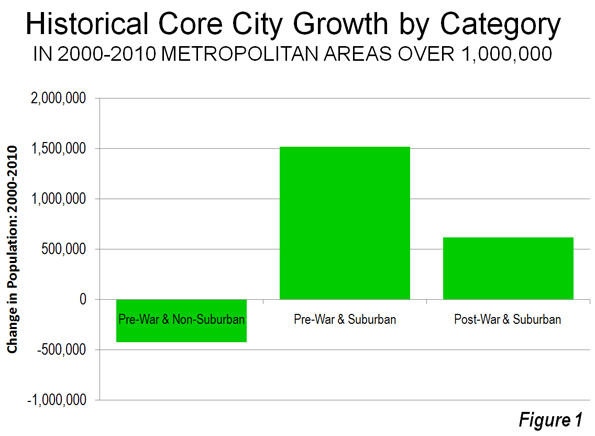
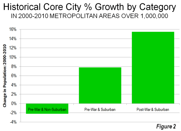
    I guess the answer is clear. Aaron Renn published a reviewofthe 2010 census, and for Chicago it was not pretty. Since 2000 the city lost over 200,000 people: nearly 7.5% of its Black residents, and almost 6% on non-Hispanic Whites. Only the Hispanic population grew, but at an anemic 3.4%. Even the metro area writ large isn’t doing all that well, growing by only 3.9% (against the nation’s 10%).

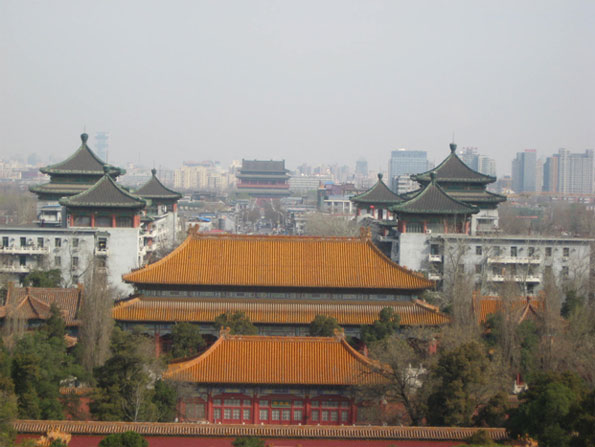
    Los Angeles, described as “a city in secular decline" appealed to the schadenfreude in my heart. As a Chicago booster, the decline of an arch-rival is emotionally (if irrationally) satisfying. But sadly, many of LA’s problems are Chicago’s issues as well: a decline of the central business district, an exodus of major businesses, the disproportionate influence of real estate on local politics, and ethnic politics. Add to that a still vibrant Outfit (mob), a lousy climate, and apart from Lake Michigan, little in the way of natural distinction, and you don’t have a pretty picture.

    Even some gentrification seems to be wearing thin. Walking along Clark St. there are plenty of empty store fronts. It’s beginning to look a little dreary (though still far from a slum).

    That all sounds pretty desperate. But there is some good news as well.

    • My wife and I inadvertently got off the Skyway one exit too soon and wound up driving down 87th St. to Stony Island. This is a thriving, middle-class Black neighborhood. Every storefront was occupied, and there was no graffiti! (Unlike graffiti-scarred Rome, which we also recently visited.)
    • Public transport is alive and well in Chicago. Trains and buses are clean, graffiti-free, and the passengers are civilized.
    • There is lots of affordable housing. Plenty of “luxury apartments” are for rent along Clark St. One can buy a perfectly nice condo for $100K or less. Many neighborhoods have been redeveloped and are really nice; Logan Square is a good example. This is the good side of the real estate bust, and gives the city a huge advantage over, say, New York or San Francisco.
    • Lakeshore Drive, Michigan Avenue, Wacker Drive, and even State Street are as fabulous as ever, especially in nice weather.

    So there is hope, but the patient is sick, and if things don’t change then Chicago could go the way of St. Louis or Detroit.

    So how can Chicago be saved? Here is my advice to Rahm Emanuel, the new Mayor.

    • Forget about the old business model – the world has changed. The days of small-time manufacturing or major banking centers are over. The notion that The Loop is going to be the home of large corporations is past. So concentrate on the new world: what can Chicago do well? I count three things: Residential, Retail, and Tourism. And Chicago has (quite inadvertently) done the residential part right. It’s the other stuff that needs attention.
    • Remember why Sears Roebuck started in Chicago: it was the center of the country. The Windy City is still is the center of the country. It should have the World’s Busiest Airport. It still is the railroad capital of America. It could be the retail capital of America. Chicago – The Loop, Michigan Avenue, Woodfield Mall, all of it – can be where America comes to shop. If relative pipsqueak Minneapolis can make a success of the Mall of America, just think what Chicago can do.
    • So – first step – lower sales taxes! We paid over 10% tax at a restaurant on Rush St. That’s crazy! Reduce sales taxes to 4% (or eliminate them entirely). Perhaps this will mean a decline in government revenue, but so what? It will create thousands of jobs and billions in business. (If politicians were really interested in their constituents rather than their own perks, this would be a no-brainer.)
    • Maintain the neighborhoods. I know the stockyards are long gone, but where is that really good steakhouse in Bridgeport? Likewise, I’m happy to drive to 87th and Stony Island for dinner and good music, but you need to ensure my safety. The city doesn’t need more real estate – it needs more cops, public transit, art, advertising, and street lights.
    • Free parking on Sundays. I know the city has taken a lot of flak for parking, but in principle it works. I parked within a couple of blocks of a fancy restaurant on Rush St. on a Friday night ($6). I parked within a block of Clark & Diversey so my wife could go shopping ($2). Before the new meters I would have had to drive around for an hour to find a place to park, and then it’d be many blocks away. Now it’s easy, and (compared to wasting time and gas) not expensive.

    But free parking on Sundays would bring them in from the suburbs in droves! New York does that, and that’s the only day we drive down to the City. Cut folks a break – it’s good business.

    • Improve public transit. That doesn’t mean new trains, but it does mean more safety. Let me take the train to Chinatown at night and have it be an enjoyable experience. Where is the convenient bus to Hyde Park? Why can’t I buy a tourist day-pass or a weekend pass for the CTA at my local station? And why do the ticket vending machines not accept credit cards? Oh, and if you do have an extra train or two, why not run A and B express trains on the Red Line? They did that 25 years ago.
    • Keep the cows. I don’t mean the stockyards, I mean the art. Of course the actual street-corner cows are passe, but Marilyn Monroe isn’t – she works. Use your architecture, your waterfront, your grand vistas. Use your imagination.

    Here is the key:  for Mayor Emanuel and for all politicians. The citizens have to earn money before you can tax it. Exorbitant sales taxes just spoil it for everybody. Yes, I know you need to spend money on schools and welfare and public-employee pensions. But you can’t do that if the money isn’t there in the first place.

    So get Chicago open for business. Lower sales taxes. Ensure public safety downtown and in the neighborhoods. Invest a little in mass transit. Give up just a bit of the parking revenue. Chicago is a great tourist and shopping destination, better than Rome in every way except ruins. Allow your citizens to cash in before Chicago itself becomes a ruin.

    Daniel Jelski is Dean of Science & Engineering State University of New York at New Paltz.

    Photo by smik67.

  • The Evolving Urban Form: Beijing

    China’s capital, Beijing, has long been one of the world’s largest urban areas. Some reports placed its population at over 1 million in 1800, which would have made Beijing the largest urban area  in the world at that time. Later in the nineteenth century, Beijing dropped below 1 million population, as London, Paris and later New York rose to prominence. As late as 1953, Beijing had a population of fewer than 3 million. Since then the city’s population has  increased more than six times (Figure 1).

    Beijing is one of China’s four "directly administered municipalities" or "provincial level municipalities," along with Shanghai, Chongqing and Tianjin (Note 1). Moreover, like Shanghai and Tianjin, Beijing is essentially a metropolitan area, composed of an urban area and exurbs approximating a labor market. This is unlike Chongqing, which has extensive rural areas and extends far beyond any plausible definition of a metropolitan area (having the land area approximately the size of Indiana or Austria).

    The Growing Beijing Urban Area: In the 1990s, Beijing added 2,700,000 people and had a population of 13.6 million in 2000. Between 2000 and 2010, Beijing population increased by more than double the previous increase, or an increase of 6 million people.

    The Expanding Beijing Urban Area: Based upon the most recent census, the next edition of Demographia World Urban Areas will estimate an urban area (urban footprint) population of 17 million, with an urban land area of 1,350 square miles (3,500 square kilometers) and an urban density of 12,600 per square mile (4,900 per square kilometer) in 2011. Beijing ranks as the world’s 12th largest urban area and is larger than any urban area in the United States or Europe with the exception of New York. As in other urban areas of China, there is considerable undeveloped land in enclaves within the suburban areas, which could develop further, raising both the population and the density.

    Falling Urban Densities: Even so, Beijing is far less dense than before. Deng and Huang at the State University of New York, Albany, place the 1949 urban land area at less than 25 square miles (63 square kilometers. Based upon its early 1950s population of less than 3,000,000, the population density of the entire urban area could have been more than 100,000 per square mile or 40,000 per square kilometer (precise urban population is not available). This is greater than the highest density major urban area today, Dhaka (Bangladesh) at 90,000 per square mile or 35,000 per square kilometer. Today’s urban Beijing may have an overall population density one-eighth that of the 1950s.

    This illustrates a reality often missed by urban analysts, who confuse population growth with increases in population density. In fact, as the Evolving Urban Form series (Note 2) indicates, dispersion is at least as important in the expansion of megacities as population growth itself. Population densities generally decline as urban areas add residents.

    Suburbanizing Beijing: Consistent with the international urban trends, most growth over took place outside the core (see table at bottom and Figure 2). As Beijing has suburbanized, it has added "ring roads," (beltways or loops) which except for the 1st ring road (around the Forbidden City) are freeways, often with Texas-style frontage roads (See "2nd Ring Road" photo). Now there are six ring roads and there has been some discussion of a seventh, which would extend to the adjacent Hebei province to the south. Real-time traffic conditions on the first five ring roads can be seen at the Beijing Traffic Management Bureau site (the 6th ring road is outside the map)


    2nd Ring Road with frontage roads

    At the same time, Beijing’s expansive suburbs do not resemble the low-density suburbanization of Phoenix, Portland, Perth or Paris. Much of the development is in high rise condominiums and a substantial part is lower quality, lower rise development that houses Beijing’s large and growing migrant population (referred to as the "floating population"), most of whom do not have Beijing resident (hukou) status. Even so, there is no shortage of detached luxury housing (called "villas") in western style developments. such as "Orange County." More recently there is increasing demand for a more modern version of the "siheyuan" (courtyard) housing makes up the renown "hutong" areas of Beijing and other Chinese cities. One website refers to the "siheyuan" as the Chinese version of the "American Dream" and a recent China Daily commentary even suggested that this type of housing should constitute the future expansion of Beijing.  However, a quick review of real estate offerings for the new siheyuans, makes it clear that they are simply unaffordable for a growing middle class that finds it difficult to afford new flats in high rises outside the 4th ring road.  

    Hutong neighborhood (Dongcheng qu)

    A map of Beijing’s districts can be seen here, with color coding that corresponds to the geographical divisions in the table.

    The Inner City: During the last census period, less than one percent of the population growth has been in the inner city, which consists of the districts of Xicheng and Dongcheng, largely inside the 2nd ring road and contains the Forbidden City, Tiananmen Square, the Drum Tower (see photo below) and Bell Tower, and the Yonghegong Lama Temple (Buddhist). These districts, which contain nearly all of the remaining hutong (see photo above) residences grew only 2.2 percent. At 61,000 people per square mile (23,500 people per square kilometer), inner Beijing approaches the population density of Manhattan or the Ville de Paris.


    Toward the Drum Tower, from Jingshan Park

    Outside the Inner City: More than 99 percent of Beijing’s growth was outside the inner city. The first and second ring suburbs accounted for 96 percent of the growth, while the outer areas accounted for three percent of the growth.

    First Ring Suburbs: The four inner suburban districts of Beijing captured 52 percent of the provincial growth between 2000 and 2000. Overall, the four suburban districts added 3.2 million people, a nearly 50 percent increase in population. The population density in the inner suburbs was 19,400 per square mile in 2010 (7,500 per square kilometer). This is a higher density than the city of San Francisco. The inner suburban districts are generally located within the 5th ring road. The first ring suburbs include the district of Chaoyang, which has the largest population and where at least one-half of the population    generally lack Beijing residency (hukou). Chaoyang is also home to the new Beijing "central business district," (CBD) which is the largest concentration of high rise towers in the urban area includes  the controversial architectural icon, the CCTV Headquarters (photo at the top). The development of the CBD in the inner ring suburbs and other major commercial development are indicative of a dispersion of employment that, if permitted to continue, could ease Beijing’s legendary traffic congestion.

    Second Ring Suburbs: The outer suburban districts accounted for 44 percent of the provincial population increase between 2000 and 2000 and 2010. However, the outer suburban districts had the highest growth rate, at 72 percent, The outer suburban districts are generally located outside the 5th ring road and include considerable rural territory. The population density is 2100 per square mile (800 per square kilometer). Beijing Capital International Airport is located in this area, though it is under the jurisdiction of the inner ring district of Chaoyang. This airport is now the world’s second busiest in passenger volume, following Atlanta and having passed perennial runner-up O’Hare International in Chicago. At current growth rates Beijing Capital International could become the world’s busiest airport within five years.

    Outer Areas: The outer areas are largely rural and well outside the urban area. Nonetheless, the growth rate in the outer areas was well above the national rate and six times the rate of the inner city. The outer areas gained 186,000 people, approximately four times the inner city gain.

    Future Challenges: The floating population Beijing (and Shanghai) represented most of the population growth from 2000 to 2010. More than 7 million of Beijing’s nearly 20,000,000 population are migrant workers.   Government officials have expressed concern at the rate of population growth and have indicated an interest in severely limiting future population growth. Among Beijing’s considerable challenges is providing sufficient water for its large population. Beijing lacks the plentiful supply of water that is available to many urban areas of central and southern China (example, Shanghai, Nanjing, Wuhan and Chongqing) and the government is building a system to divert water especially from the Yangtze River. The 2020 census results could reveal a significant slowdown in growth, if these problems are not sufficiently addressed. 


    Beihei Park

    Wendell Cox is a Visiting Professor, Conservatoire National des Arts et Metiers, Paris and the author of “War on the Dream: How Anti-Sprawl Policy Threatens the Quality of Life

    ——–

    Note 1: What are translated as "cities" in China are not cities as understood in the West. A "shi" in China (translated as "city") is actually a region that may approximate a metropolitan area or labor market area in the West (with an urban core and a much larger surrounding rural territory). Some "shis" are much larger, however, such as Chongqing, which covers a land area similar to that that of Austria and nearly as large as Indiana. Chongqing and many other "cities" are far larger than any plausible metropolitan area definition.

    "Shi" may exist either at the provincial level (as in the case of Beijing, Chongqing, Shanghai and Tianjin) or it may exist within a provincial level jurisdiction, such as Nanjing in Jiangsu. Guangzhou in Guangdong or Wuhan in Hubei. Every square mile of a province (excepting the provincial level jurisdictions) is divided into shis, prefectures or comparable units, in the same way that US states are divided into county level jurisdictions or the regions of France are divided into departments. To complicate matters more, shis themselves may have county (xian) level shis within their borders, such as Cixi, a county level shi with approximately 1,000,000 people within the Ningbo shi in Zhejiang province.

    Note 2: Other megacities reviewed in this series have been: Jakarta, Los Angeles, Manila, Mexico City, Mumbai, New York ,Seoul and Shanghai .

    Photo: CCTV Headquarters in new Beijing CBD, Chaoyang district. Photo by Iamdavidtheking.

    All other photos by author.

  • Australia Central Banker: Higher House Prices a “Social Problem”

    Glenn Stevens, the Governor of the Reserve Bank of Australia expressed concern about the growing gap in housing affordability in the nation to a parliamentary committee on Friday. Stevens raised questions about the cost and supply of housing, asking:

    "How is it that we can’t add to the dwelling stock for the marginal new entrant more cheaply than we seem to be able to do," he asked.

    According to an article in the Perth Western Australian ("High price of homes ‘stealing future’") Stevens went on to say that key State and local government issues around supply, zoning, transportation and infrastructure seemed to be making a simple block of land more expensive than was necessary.

    Virtually all of Australia large urban areas have implemented urban containment policies (called "urban consolidation" in Australia and "smart growth" in the United States). The result has been to increase house prices from 2 to 3 times the historic norm relative to incomes. These price increases are consistent with the overwhelming economic evidence of a strong association between urban containment policies, especially those that ration land for development through devices such as urban growth boundaries.

    The Chairman of the Reserve Bank of New Zealand has identified a 10-times "across the urban growth boundary value" difference per acre in Auckland, which is similar to findings in Portland, Oregon.

    Stevens concluded his housing comments noting that: "There’s a very big inequality between generations building up and I think that’s a social problem as much as any economic point."

  • New Zealand Leader Focuses on Association between High House Prices and Growth Management

    ACT Party leader Donald Brash, who served from 1988 to 2002 as the Governor of the Reserve Bank of New Zealand (similar in function to the Federal Reserve Board) has noted the poor housing affordability in New Zealand and its connection to growth management policies (called by various names, such as "smart growth," "growth management," "compact cities," "densification" "prescriptive land use regulation" and "urban consolidation").

    In an August 25 speech Brash said:

    "It is impossible to avoid the conclusion that the interaction of the RMA, the Local Government Act and local government staff all over the country has produced a major obstacle to improved living standards.

    One of the ways this has happened is through the way in which this interaction has pushed the price of housing well beyond the reach of far too many New Zealanders – or more accurately, has pushed the price of residential land well beyond the reach of far too many New Zealanders.

    We know, from the annual surveys undertaken by the Demographia organisation, that housing in our major cities is now among the most expensive in the world, relative to household incomes. And why? In large part because too many local governments have quite deliberately limited the supply of residential land.

    Arthur Grimes, now chairman of the Reserve Bank, found that the effect of the Metropolitan Urban Limit imposed by the Auckland Regional Council had increased the price of land just inside that Limit by some 10 times compared with the price of land just outside the Limit.

    This is absolutely nuts, in a situation where New Zealand is one of the most under-populated countries in the world, and where Auckland is one of the most densely populated cities in the world – in terms of people per square kilometre, Auckland is more densely populated than Vancouver, Melbourne, Portland, Adelaide, Perth or Brisbane.

    I’m delighted that one of the first projects of the newly-established Productivity Commission is to look into the affordability of housing."

    The finding of a 10-times "across the urban growth boundary value" difference per acre in Auckland, is similar to findings in Portland, Oregon.

    Dr. Brash had previously written (the "Median Multiple is a measure of housing affordability, with higher number indicating less affordable housing. It is the median house price divided by the median household income):

    "… the one factor which clearly separates all of the urban areas with high Median Multiples from all those with low Median Multiples is the severity of the artificial restraints on the availability of land for residential building"

  • Austin’s Not That Weird

    Don’t let the cupcake stands fool you. For years, locals pressed the need to Keep Austin Weird. Besides spawning lazy clichés (Keep Austin Wired, Keep Austin Moving, Keep Austin on Every List of Best Places to Live), the Keep Austin Weird movement overlooks the obvious: the city’s not that weird.

    Weird for Texas? Sure. Austin is like a rebellious preacher’s kid. It’s cool, popular, breaks all the rules, and doesn’t go to church very much. Family members from elsewhere visit from time to time, but everyone wonders if they’re all part of the same family.

    It’s been this way forever. When most of the state decided to join the Confederacy, Austin declined. When most of the state decided to join the Republican Party, Austin declined.

    The capital is more counter-Texas than counter-culture. Austin boasts unique attractions, festivals, and music venues. It’s livable, a hard term to quantify until Austinites visit other cities and return recounting their flaws. Austin also has an infectious, welcoming spirit. You can strike up random conversations with random people at the grocery check-out. Still, it’s not as strange as advertised. Let’s dispel the most common myths:

    MYTH #1: It’s San Francisco. It’s not. The City by the Bay is smaller, denser, and more ethnically diverse. Both cities have roughly equal populations, but Austin packs them into approximately 300 sq. miles; Austin is six and half times larger than San Francisco. Neither city has a white majority, but nearly one in two Austinites is white, compared to just four in ten San Franciscans. So Austin’s full of Stuff White People Like: trailer food, snow cone stands, vintage clothiers, writer’s groups, Paleolithic restaurants, coffee shops, and yoga studios. It’s not the gayest city in Texas, either. Dallas narrowly edges out Austin, according to analysis by the Williams Institute at the UCLA School of Law.

    MYTH #2: It’s a small town. As the 14th largest American city, Austin has big city problems.

    Traffic tops the list. Forget rush hour. It’s not unusual to find your car parked on I-35, the city’s clogged artery, on a Sunday afternoon. The ill-equipped interstate reflects city planners’ inverse Field of Dreams strategy: if you don’t build it, they won’t come. Back when Austin really was a small town, some thought expanding I-35 would encourage newcomers. They came anyway.

    A growing metropolis suffers growing pains, and Austin hasn’t outgrown racial or economic segregation. Housing costs, among the state’s highest, contribute to geographic divisions. The city’s affluent congregate in the west side, while middle-earners who want homes settle near, or in, once-empty Williamson and Hays counties. Austin’s east-siders are mostly low-income minorities, but as The Atlantic’s Ta-Nehisi Coates observes, gentrification is changing this.

    In search of cheap in-town property, a mix of white urban professionals and bohemians started sprucing up homes just east of I-35 over a decade ago. High-end lofts now co-exist, a bit awkwardly, next to mercados. The east side has become less a barrio, with new stores, houses, and other developments dotting neighborhoods. Still, it’s no yuppie playground.

    MYTH #3: It’s Babylon. Fear not, God-fearing Americans! Austinites aren’t as eccentric or wayward as you may have heard. For years, natives have touted wandering gender-bender Leslie Cochran as their mascot. To locals, Leslie embodies Austin’s free-spirit; to outsiders he’s evidence Austin is Gomorrah near the Guadalupe. Leslie nearly died in 2009, however, and Jennifer Gale, a homeless transgendered activist, died in the cold in 2008. Austin still has its fair share of eccentrics—the unicycle, mind you, is a perfectly acceptable mode of urban transport—but you won’t find fire-eaters on every corner.  

    This city of alleged non-conformists dresses the same (and never up). Shorts and flip-flops, the uniform of least resistance, will get you in nearly any club or restaurant. The University of Texas, state government, and tech companies compose Austin’s economy. Professors, bureaucrats, and software engineers—let the Bacchanal begin! During South by Southwest, locals can easily pinpoint the Bay Area-Portland-Williamsburg interlopers. As they party, promote, and pose, the skinny jean set manically turns their attention from iPhones to panel discussions to guest-list gatherings. Austinites run at a more relaxed pace. Unlike these coastal scenesters, they would rather chill out than stand out.

    MYTH #4: It’s not like other cities. In many ways, Austin is exceptional. The urban core features gems like Zilker Park, a marvelous pink granite Capitol, and home-grown eateries. Leave the central core, however, and you quickly encounter big-box sameness.

    As you head south of Ben White Boulevard or north of the University of Texas, national retailers, food chains, and strip malls appear. Once a destination concert venue, Southpark Meadows is now a destination for south Austin Target shoppers. Up north, The Domain, an upscale shopping village, gives off a gentle North Dallas pretention, which is the opposite of Austin weird.

    Even Whole Foods, the Temple of Austin, causes headaches. The retailer is Disneyland for foodies, if you can get there or find parking. Sky-rise condos flank the flagship store, and getting past nearby intersections and into a parking space can feel like a bumper car ride. This congested urban development angers locals who fear their homeland now caters to well-off creative professionals instead of cash-strapped musicians and artists.

    No wonder some residents feel compelled to remind everyone to Keep Austin Weird. Put it on a tee-shirt. Put it on a bumper sticker. Shout it from your co-op’s rooftop: I have seen the Promised Land, and it is (or was) weird.

    How odd that a progressive city would revert to this reactionary battle cry. Those who love the phrase look back and see an odder, better place or ahead and see disturbing signs of normalcy. Both sales pitch and civic anthem, the Keep Austin Weird campaign aspires to change development through mantra. Like a New Age chant, it hopes to alter consciousness. If you say it enough, maybe it will come true.  

     Does Austin have to be weird to be special? It has plenty of attractive, well-educated citizens, natural beauty, and warm weather (record-setting levels this year, in fact). It’s still far cheaper than most coastal meccas. When magazines rank it as a great place to move or start a business, weirdness isn’t their criterion. Despite the big city headaches, the quality of life is still pretty sweet. Can’t we just follow The Beatles’ advice, and let Austin be?

    Writer Jason Thurlkill grew up near Dallas. He reported for “The Hotline” and a “New York Observer” publication. Previously, he worked for a Washington D.C. political consulting firm. He studied government at the University of Texas and earned his Master of Public Policy at the University of Chicago.

  • Suburbanized Core Cities

    The suburbs of major metropolitan areas captured the overwhelming majority of population growth between 2000 and 2010, actually increasing their share of growth, as has been previously reported. However, it is often not understood that much of the recent central city (Note 1) growth has actually been suburban in nature, rather than core densification. In fact, historical core cities (Note 2) vary substantially. In some cases, core cities are largely pre-war and transit oriented, such as New York, Chicago and San Francisco. In other cases, much of historical core city is automobile oriented suburban in character. This article provides a classification of historical core cities based upon the extent of their pre-automobile cores as well as population and land area data.

    Central Cities before World War II: Auto-oriented suburbanization began before the Great Depression.  In 1940, transit’s urban market share in the United States appears to have been higher than that of Western Europe today (Note 3). Each of the nation’s largest metropolitan areas (then called "metropolitan districts") boasted a strong, dense core, and could be generally delineated by the city limits of the largest municipality.

    In the years after the Second World War, many cities annexed considerable territory. At the same time, a number of new major metropolitan areas emerged which effectively lacked a dense core. For the purposes of analysis, the historical core cities of the 51 major metropolitan areas (those with more than 1,000,000 population) have been divided into three categories, based upon the extent of the suburban development within their borders. The categories are defined in Table 1 and data is provided in Tables 2 and 3 in the attached PDF document.

    Table 1
    Classification of Historical Core Municipalities

    Nature of Historical Core Municipality:
    Classification based upon 2010 City Limits

    Large Urban Core in 1940?

    2010
    City Limits

      Pre-War & Non-Suburban

    Yes

     Is pre-war core; nearly all included land area was developed by 1940. Little development that is post-war suburban in character. Little or no change in boundaries since 1940.

      Pre-War  & Suburban

    Yes

    Includes pre-war core, however contains substantial development that is post-war suburban in character (2010 boundaries contain substantial areas that were greenfield in 1940)

      Post War & Suburban

    No

    Has smaller pre-war core: less than 100,000 population in 1940 and nearly all development is post-war suburban in character.

    The historical core municipality is the municipality with the largest 1940 population in the present metropolitan area (metropolitan statistical area).
    There can be more than one historical core municipality in a metropolitan area, with the exception below.
    There can be a second historical core municipality if (1) it is adjacent to a historical core municipality classified as "Pre-War  & Non-Suburban," (2) had a 1940 population at least 25 percent of the first historical core municipality and (3) a population density of at least 5,000 per square mile.
    Multiple municipality names listed in some other metropolitan areas for reference purposes.

    Pre-War & Non Suburban: The first category is the "Pre-War & Non Suburban" historical core cities. Each of these 19 cities is itself a pre-automobile core. City boundaries have changed little since before World War II and nearly all land was developed at that time (Note 3).

    Overall, these cities had a population density of 11,900 per square mile in 2010 (Figure 1). However, 16 of the cities have lost population since 1940, with only New York, San Francisco and Oakland having gained population, albeit very modestly. (Oakland lost population over the past decade.) Between 2000 and 2010 the "Pre-War & Non Suburban" historical core cities lost 424,000 people, or 2.2 percent of their population (Figures 2 and 3). Seven gained population, though in five of these cases (Boston, Hartford, Philadelphia, Providence and Washington) the 2010 population remained well below mid-century levels.

    Pre-War & Suburban: The second category is the "Pre-War & Suburban" historical core cities. These 27 cities had pre-automobile cores, usually quite small, in 1940, but also include (in their 2010 borders) substantial land that was undeveloped in 1940. Substantial automobile-oriented suburban development has occurred in these areas. The strong automobile oriented suburban influence is indicated by the average population density of 2900 people per square mile of land area, approximately one-fourth the density in the "Pre-War & Non Suburban" category.

    On average, the 2010 land area of the "Pre-War & Suburban" historical core cities is 3.2 times the land area of the corresponding urban areas in 1950 (areas of continuous development or the "urban footprint"). These urban areas included both the historical core city and the suburbs (Note 4).   The city of Jacksonville covers the most land area relative to its 1950 urban area, at 14.7 times. The city of Portland, the recipient of frequent praise by advocates of densification, covered more area in 2010 than its entire urban area in 1950 and its population density today is less than that of the entire urban area in 1950.

    The "Pre-War & Suburban" historical core cities added 1,520,000 people between 2000 and 2010. This translates into an average growth of 7.8 percent relative to the 2000 population. Three cities grew more than 100,000. Louisville added 341,000 people principally through a city – county merger, after its previous annexations had failed to stop its population decline. Between 1950 and 2000, Louisville has lost nearly one-third of its population while adding more than 50 percent to its land area.

    Charlotte added 191,000 people, principally due to a continuing annexation program. San Antonio and Houston took advantage of considerable undeveloped land within their city limits to add 183,000 and 146,000 people respectively.

    Post-War & Suburban:  The third category is the "Post-War & Suburban" historical core cities. None of these seven cities had more than 100,000 population in 1940 or a large pre-automobile core; these are essentially suburbanized cities.  In each case, the cities have undertaken huge annexations. On average, the 2010 city limits include nearly 6 times as much land as the corresponding urban areas in 1950. The city of San Jose, known for its densification policies, covers nearly 3 times as much land as its entire urban area in 1950, which included the city and all of the suburbs (Figure 4).

    The "Post-War & Suburban" historical core cities added 619,000 people between 2000 and 2010, for an increase rate of 15.5 percent, the largest percentage growth of the three categories.

    Perhaps surprisingly the population density of the "Post-War & Suburban" historical core cities was one-quarter above that of the "Pre-War & Suburban" category, at 3700 per square mile. This may be at least partially driven cities like San Jose, Las Vegas and Riverside-San Bernardino, which have generally avoided planning that required larger lots and below market densities.

    The cities of Philadelphia and Phoenix reflect these differing patterns.   In 2010 Philadelphia had a population density of more than 11,300 people per square mile and covered an area of 135 square miles. The city of Phoenix had a population density of under 3000 people per square mile and covered more than 500 square miles. Not even one square mile of the 2010 city of Phoenix equals the average density of Philadelphia. In 1940, Philadelphia had a population of 1.9 million, 30 times that of the 65,000 in Phoenix.

    As would be expected in a dense historic core city, Philadelphia has a substantial transit work trip market share, at 25 percent. This is five times that of the surrounding suburbs (5 percent). In contrast, the city of Phoenix has s a transit work trip market share of only three percent, below that of the Philadelphia suburbs. 

    Suburban Development Makes Cities Grow: As the data above indicates, virtually all net core city population growth over the past decade has been suburban in nature. Core cities characterized by substantial automobile-oriented suburbanization added more than 2.1 million residents, while the cities with little   automobile-oriented suburbanization lost more than 400,000. It turns out that even most “core” cites are more suburban than many imagine.

    ——————–

    Note 1: "City" has multiple meanings and analysts have not always provided  sufficient clarity when using the term. For example, "city" can mean a metropolitan area, and urban area, a municipality (incorporated jurisdiction) or as in China, a region either at the provincial or sub-provincial level. As used in this article, the term "city" means a municipality unless otherwise indicated.

    Note 2: The historical core city is the city in the present metropolitan area that had the largest population in 1940. Usually, this is the first named city in the official Census Bureau title. However, in two cases (Virginia Beach-Norfolk and Riverside-San Bernardino), the second named city is the historical core city because it was the largest in 1940.

    Note 3: There are no comparable data on overall transit market shares between Europe and the United States. However, Eurostat data for nearly 150 European metropolitan areas indicates that transit’s work trip market share averages approximately 17 percent. The same population range (over 100,000) of US metropolitan areas has a transit work trip market share of six percent. In 1940, the overall US transit market share was approximately 14 percent. Because transit work trip market shares are generally substantially higher than overall shares, it is suggested that the 1940 US transit market share was greater than the current share in Europe.

    Note 4: The city of Chicago made a substantial annexation largely to incorporate the land for O’Hare International Airport. This annexation did not materially increase post-war suburban development in Chicago and the city is thus classified as "Pre-War & Non-Suburban."

    Note 5: 1950 used because urban areas were not designated before that time.

    Wendell Cox is a Visiting Professor, Conservatoire National des Arts et Metiers, Paris and the author of “War on the Dream: How Anti-Sprawl Policy Threatens the Quality of Life

    Photo: City of San Antonio annexation map from the San Antonio Planning and Development Department. The red rectangle is the land area of the city in 1940. 

  • The Decline and Fall of the French Language?

    It’s been indisputable for some time that English is becoming the ‘universal language’. As the number of living languages has steadily decreased, the use of English has expanded on every continent. And though English has not — despite predictions — crushed all other languages (German, Russian, and Spanish, to cite the prime examples, all remain strong), one language does seem to be undergoing the predicted cataclysmic collapse. English may not yet have won the globe, but French has definitely lost it.

    The reasons for the decline of French are many, including geography. Francophone regions are spread out: think of France, Vietnam, Quebec, and Guadeloupe, to start. Many of these regions are without direct connections to other French-speaking countries. The result is that many of the people choose to abandon French for more useful languages within the region. In contrast, German, Russian and Spanish speakers are based in numerous adjacent countries, each supporting the others.

    French has been most visibly hurt in the last few decades in Africa. In North Africa, French has had to compete with Arabic, a language which Arabs are now clinging to as proudly as the French have traditionally clung to French. South of the Sahara, countries which formerly had large French-speaking populations are making the switch to English due to its relevance in Southern Africa, as well as internationally.

    In Algeria, after the Algerian War, French was mostly expunged. Its decline has continued, including the recent closure of French schools, as Arabic and English become the standard.

    More dramatically, in Zaire, in 1997, fueled by anti-French sentiment, the French language was replaced with native languages. And in nearby Rwanda the president has pushed for the abandonment of French in favor of English. It is questionable whether any Africans will be speaking French in a few decades.

    English, meanwhile, is becoming the most important Western language in Africa, replacing both French and Portuguese. An English derivative is the majority language of Sierra Leone, and remains an important language in South Africa, of course, as well as Nigeria, and various other smaller countries.

    Former French-speaking colonies beyond Africa have been hostile to the French language. French has been collapsing even faster in Asia than it is in Africa, due to the isolation of French-speaking populations. In Vietnam, students have protested having to learn French, stressing the need to learn English instead. And in the Middle East, the Lebanese have been shucking off French in favor of English.

    French has also seen a drastic decline in North America. In the U.S., between 1990 and 1995, college applicants for French class declined by twenty-four percent. In Canada, the number of French students enrolling in English classes is rising rapidly, while the overall percentage of French speakers across Canada is falling.

    Across Europe, French has gradually declined from being the lingua franca to falling behind German and English. English is spoken by 41% of Europeans, while only 19% speak French. English is now the language of business in Europe, a fact which even French ambassador for international investment Clara Gaymard was forced to admit. And French has fallen so far behind in Eastern Europe, in particular, that it is the third-most studied language, behind English and Spanish.

    While once the language of culture, French has been pushed off the global stage. Perhaps the most symbolic example of this was in 2008 when Sebastian Tiller, the French representative at the Eurovision contest, planned to sing ‘Divine’ almost exclusively in English. That the French singer did not choose to represent the jealously guarded language of his country internationally came as a shock to many. This cultural decline was mirrored when New York’s Metropolitan Opera decided to reject the libretto of the musical star Rufus Wainwright (who was raised in Canada), because he chose not to translate his opera into English.

    The calamitous decline in French seems irreversible, even to the French. In 2008, the budget of La Francophonie, the governing body of the French language, was six million euros; in contrast, the British Council announced it would spend 150 million euros in efforts to advance English.

    In any Darwinian model, a characteristic can become prominent, or it can be driven out of existence. Use of the French language has been globally dispersed, and French culture is without historical significance in many of its colonies. These are not the characteristics that increase a language’s chances of survival.

    Photo by funtik.cat (Dasha Bondareva).

    Gary Girod graduated Cum Laude from Chapman University in Spring, 2011 with a dual major in European History and French. His work includes creating historical collections for Chapman’s Leatherby Libraries. He is also analyzing unpublished primary materials which will be turned into a narrative-driven history of one business magnate’s life during the Industrial Revolution, for Paragon Publishing.

  • Why the Green Jobs Movement Failed

    "Federal and state efforts to stimulate creation of green jobs have largely failed," the New York Times reported last week, drawing similar conclusions to the ones we drew in our essay for The New Republic last October. Silicon Valley, home to the green jobs movement, actually saw the number of green jobs decline from 2003 – 2010.

    The signature green jobs program was retrofitting homes and buildings to become more energy efficient, which boosters thought would create "millions" of jobs in the inner-city. In 2009 the Center for American Progress claimed that $5 billion in stimulus funding for weatherization and a price on carbon would lead to the retrofitting of every building in America in ten years, generating 900,000 jobs. In reality, we noted in TNR, the weatherization program had created just 13,000 jobs. "Two years after it was awarded $186 million in federal stimulus money to weatherize drafty homes," the Times reported, "California has spent only a little over half that sum and has so far created the equivalent of just 538 full-time jobs in the last quarter… the program never really caught on as homeowners balked at the upfront costs."

    Most of the approximately $70 billion in green stimulus money went to retrofitting or stimulating the old economy and just one-third went to building a new one. Notably, even those modest investments in manufacturing and technology had a salutary effect, saving the American renewables industry, which was in free fall after the 2008 financial crisis, and giving a boost to U.S. manufacturers of electric car batteries. 

    Obama could have focused on winning a long-term commitment to public investment in green innovation and manufacturing. Instead, he threw his political capital behind cap-and-trade, a pollution control program that was never imagined by the economists who invented it to be a means for creating vibrant new industries.