Blog

  • Transport in Moscow

    I was in Russia last week and plan to share a few relevant notes from the trip. Since you can easily find better photos of places like the Kremlin than I’ll ever take online, when it comes to Moscow I’m going to focus on more planning and transport items. There’s a lot of other commentary I might make, and if you want to read it, be sure to sign up for my exclusive content by email if you haven’t already, because I may write up further observations on the political scene there.

    Writing anything positive about public space and transport in Moscow runs the risk of coming across as seeming to say that “at least Putin makes the trains run on time.” But as he is fully occupied with such critical tasks of state as destroying illicit supplies of Nutella and brie, I doubt he’s bothering himself with such prosaic concerns as transport. Should you be interested, the NYT just ran a good piece on the combination of urban improvement and authoritarianism in Russia’s capital city.

    Moscow reminded me a bit of an inverted Buenos Aires. Whereas in BA you get a clear sense that this was once the Paris of South America now well faded, Moscow comes across as a dilapidated city on the rise. You definitely see plenty of run down communist era architecture – the quantity of Corbusian nightmares evident from an aerial view of the city is astonishing – but there are new buildings on the rise and significant evidence of attempts to improve the lived experience of the city.

    Moscow is clearly a driving and transit city, not a walking city. Though there is some street life, it’s far lower than comparable high density megacities. But before knocking them too much, keep in mind that Moscow gets bitterly cold in the winter. Even in August the temperature in the afternoon was only the low 70s. Ideal to be sure, but that’s only for a narrow window of the year. Moscow is at 56 degrees north latitude compared to 41 in New York. Moscow is actually further north than every major Canadian city. The sky was already getting light before 4am.

    Nevertheless, the outdoor experience there is being enhanced through a number of projects.

    Moscow River

    The Moscow River flows through the city, passing alongside the Kremlin as you can see in his photograph.

    Moscow - August 2015

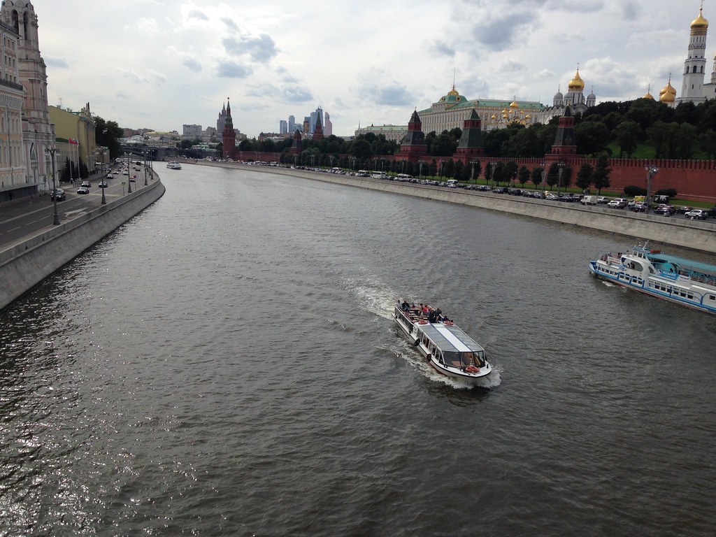
    You see that on both sides it is lined with roads and very narrow sidewalks. It’s not even clear how you would easily get to the riverside on the Kremlin side. A stroll along the bank across from the Kremlin, Cathedral of Christ the Savior, and other landmarks should be amazing, but it is not.

    There’s apparently a tender underway that would completely redo this for the better. In the meantime, one section of the river called the Krymskaya Embankment has been redone to a slick, albeit somewhat generic design. This has radically transformed the riverfront for the better, and if the rest of the Moscow River upgrade is similar, this will be a huge transformation for the city.

    Moscow - August 2015

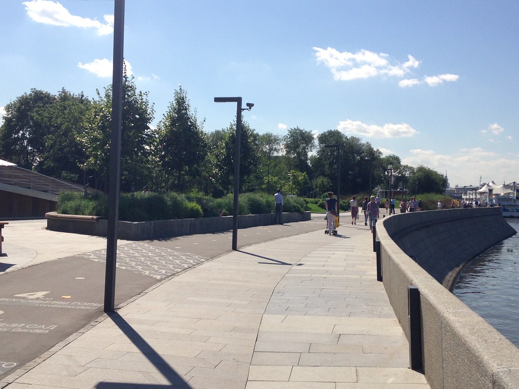
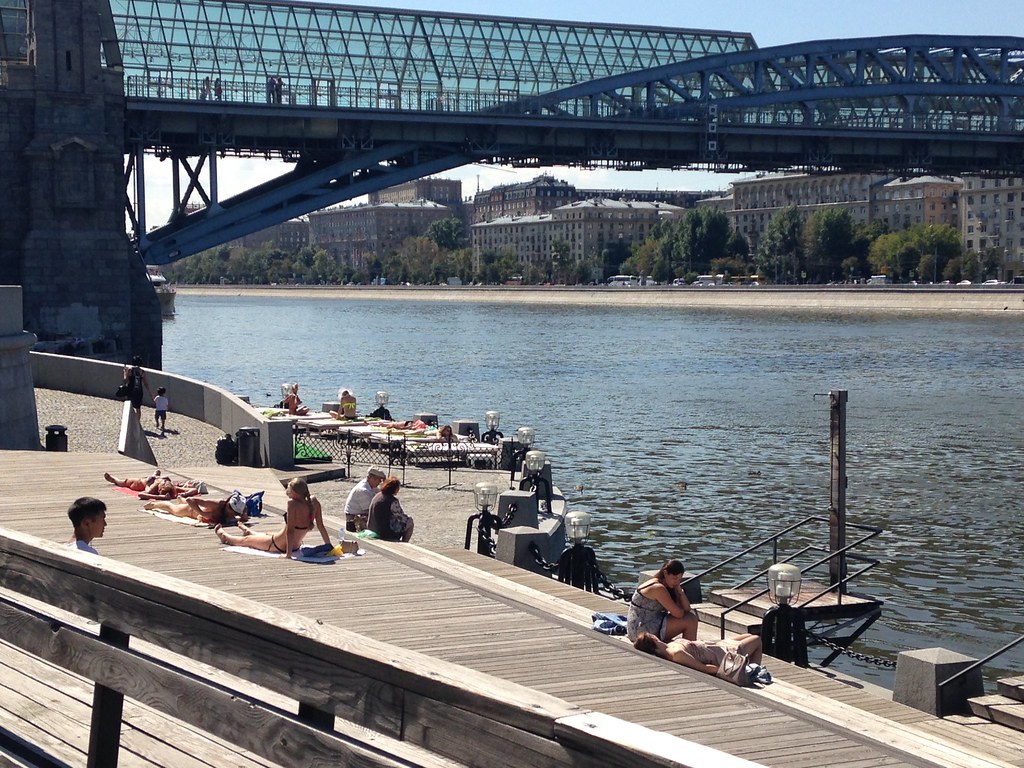
    People enjoying the waterfront.

    Moscow - August 2015

    Here’s a closeup of the bike lane.

    Moscow - August 2015

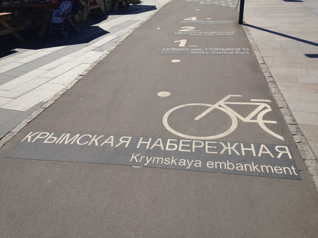
    The numbers and the text in the background give distances to attractions such as Gorky Park.

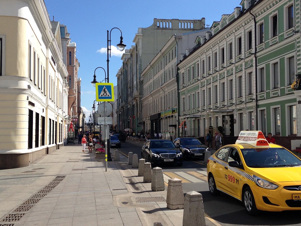
    Neighborhood Streets

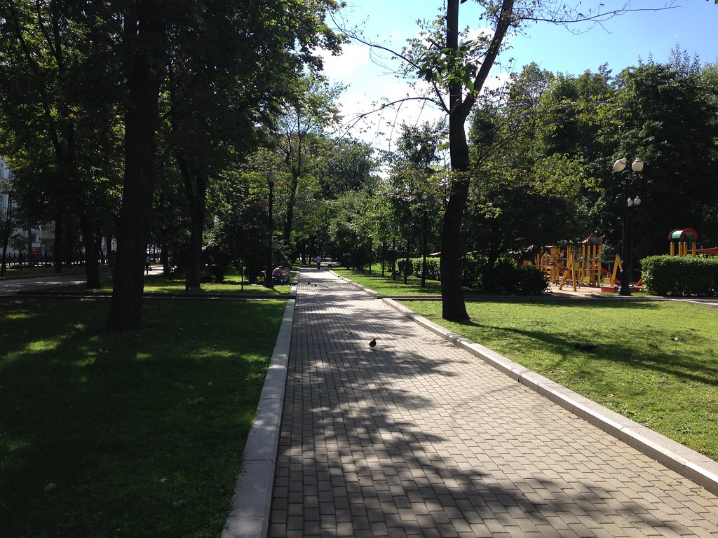
    In a way similar to the riverbank, there’s been an effort to upgrade neighborhood streets to improve the pedestrian experience. Traditionally, these have had fairly narrow, basic sidewalks. Here’s a typical example:

    Moscow - August 2015

    And here’s a street that’s been put on a road diet.

    Moscow - August 2015

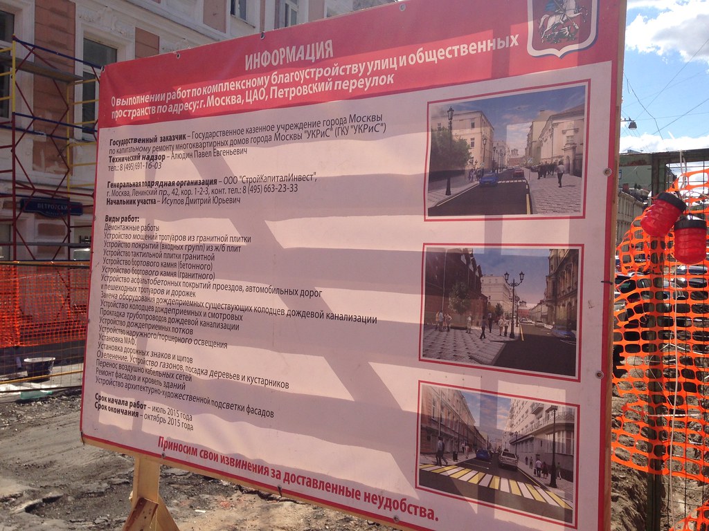
    This program is ongoing, as this sign touting forthcoming improvements shows.

    Moscow - August 2015

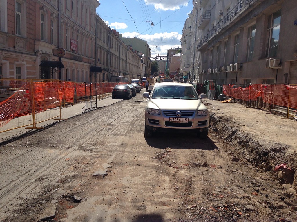
    And a picture of the construction in progress.

    Moscow - August 2015

    There’s also a bike share system.

    Moscow - August 2015

    Arterial Streets

    While there are plenty of smaller, human scaled side streets in Moscow, the arterial roads are mega-wide thoroughfares (“prospekts” in the local parlance) that function as quasi-freeways. Here’s an example that isn’t a perfect photo, but let’s you get the gist of it.

    Moscow - August 2015

    You’ll see at least six lanes in a single direction. This building is actually decent, but illustrates what you also see along these high capacity arterials, namely a preponderance of horizontally oriented buildings. Even with broken up facades, these are buildings that are most legible at driving speeds, not walking.

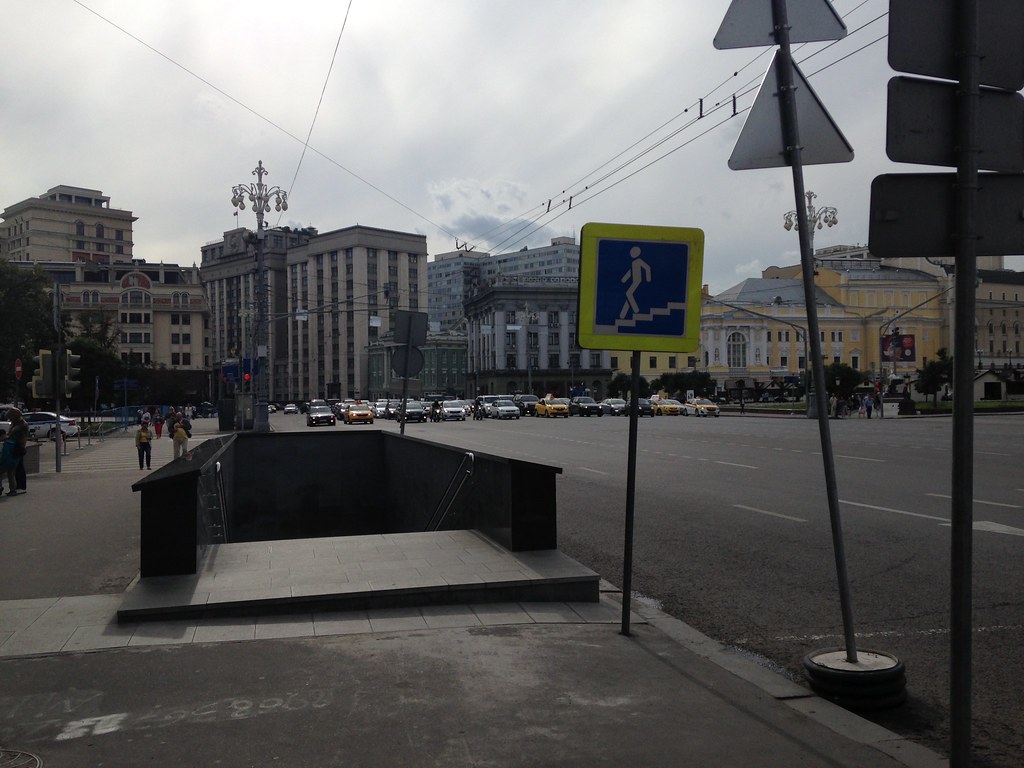
    You might wonder how people cross these things, and the answer is that they mostly don’t. For these streets, there’s a heavy reliance on pedestrian underpasses for pedestrian safety. (This also reduces the number of stoplights, which allows for long distances of high speed travel even in the center city). Metro entrances also do double-duty as protected passageways through intersections. Here’s an entrance to one such pedestrian underpass along a one way street that appears to be ten lanes wide.

    Moscow - August 2015

    This might seem inhumane, and it is. But it also functions well. Though I’m told traffic is much lighter in the summer when many vacate the city, there is nothing like the gridlock of a New York, and these roads tended to move pretty good most of the time I was there.

    Where there were crosswalks, they featured countdown timers on both the walk and don’t walk cycle.

    Moscow - August 2015

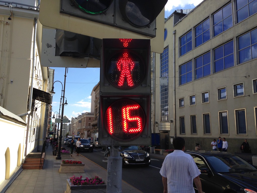
    That’s not a misprint. Some of these lights have extremely long cycles.

    Some arterials have a nicer design. One is the so-called “boulevard ring,” which is one of the many ring roads in Moscow. I think (though can’t promise), this shot is from it. Even if not, it’s representative of its design.

    Moscow - August 2015

    Moscow Metro

    Moscow is famous for its metro system, which is one of the world’s busiest and has lavish station designs. I saw some of these and they are indeed pretty great, though this system should never be applauded without remembering that it was built with gulag labor. Again, I won’t show many pictures of the stations, since my iPhone isn’t the best at low light underground shots. Google is your friend on this.

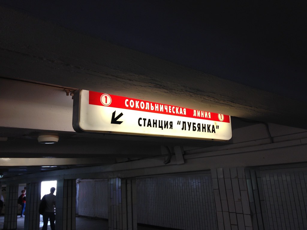
    The metro fare is about a buck. Tap cards are sold at automated kiosks that have English available. Lines are numbered and color coded. Here’s an example of the system signage.

    Moscow - August 2015

    It’s one train right after the next more or less. Even at 11:30 pm there were three minute headways. The cars are older but function well, and there is wifi, which I’m told works even between stations.

    Moscow - August 2015

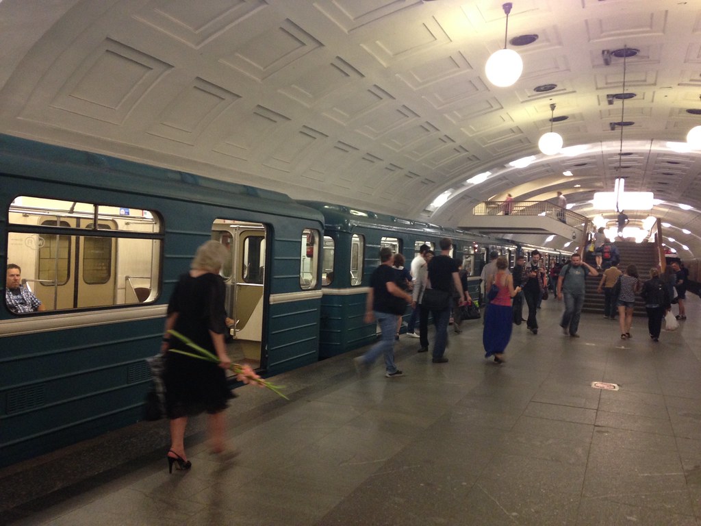
    There are some newer cars that appear to be married pairs with open gangway between the two linked carriages, but not between pairs.

    While you can buy a ticket in English, the bulk of the signage is in Russian only. This isn’t a problem for the most part, but I found the remembering station names in the Cyrillic alphabet was a challenge compared with Latin alphabet stations in other foreign countries. I would suggest that the station name be transliterated into Latin script to make the system more friendly to international users. (The rest of the signage is fine as is). Here’s an example:

    Moscow - August 2015

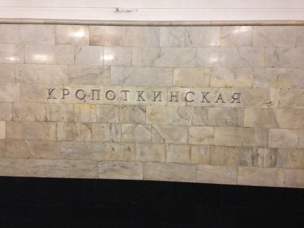
    If I translate that right, this station is Kropotkinskaya (Kropotkin was a Russian intellectual of the 19th and early 20th centuries). The name is certainly easier to recognize in Latin script for westerners (and probably most others who use English as their international lingua franca). But even in Russian only, you should be able to figure it out how to navigate the system if you pay close attention.

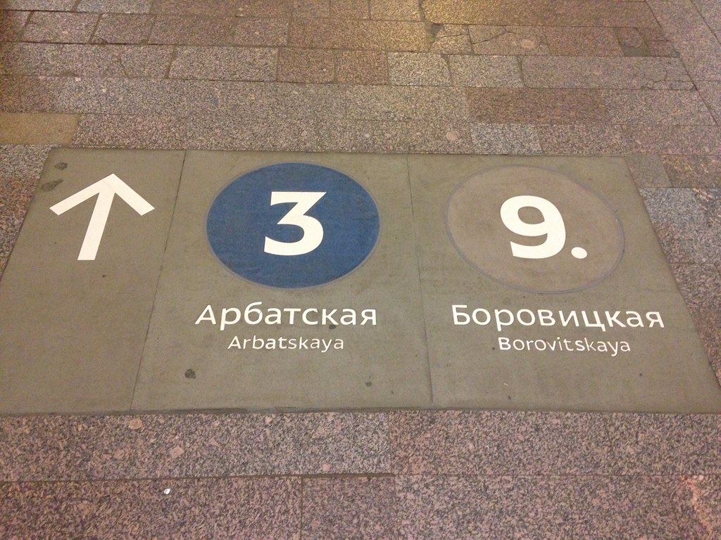
    Here’s an example of some transliterated signage. This probably goes above and beyond the call of duty as the numeric indicators suffice.

    Moscow - August 2015

    Air Travel

    Moscow has two main airports, I believe, both at a significant distance from the city center. I flew using Sheremetyevo, which is serviceable if not overly pleasant. You have to pass through security immediately upon entering the terminal, then again when going to the gate area. Even domestic transfers require re-screening and passport checks. (I was told by a local, “Russians love checking passports.”)

    The most depressing part of the trip was flying three domestic segments on Aeroflot. When I was younger they had an extremely bad reputation, and flew of a fleet of dodgy Soviet made jets. Today, the planes I flew on were newish A-320s and the service levels exceeded US domestic standards (though that’s a low hurdle to jump). They even still serve food on short haul flights. Quite a role reversal there. Red is still their flight attendant colors, and their hammer and sickle logo is still in use.

    High Speed Rail

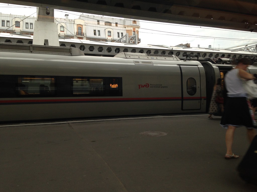
    There are a number of rail routes throughout the country, and while I didn’t make a comprehensive survey, I did ride the high speed “Sapsan” service from St. Petersburg to Moscow. IIRC, the fare was around $55. Though using Siemens trainsets derived from the rolling stock used on Germany’s ICE trains, the max speed was 220 km/h (135 mph), comparable to the Acela. However, unlike the Acela, the Sapsan cruises at 200 km/h or higher most of the trip. The journey takes a bit less than four hours and is a pleasant way to travel.

    Here’s a picture of one of the trains I took in St. Petersburg’s Moscow Station.
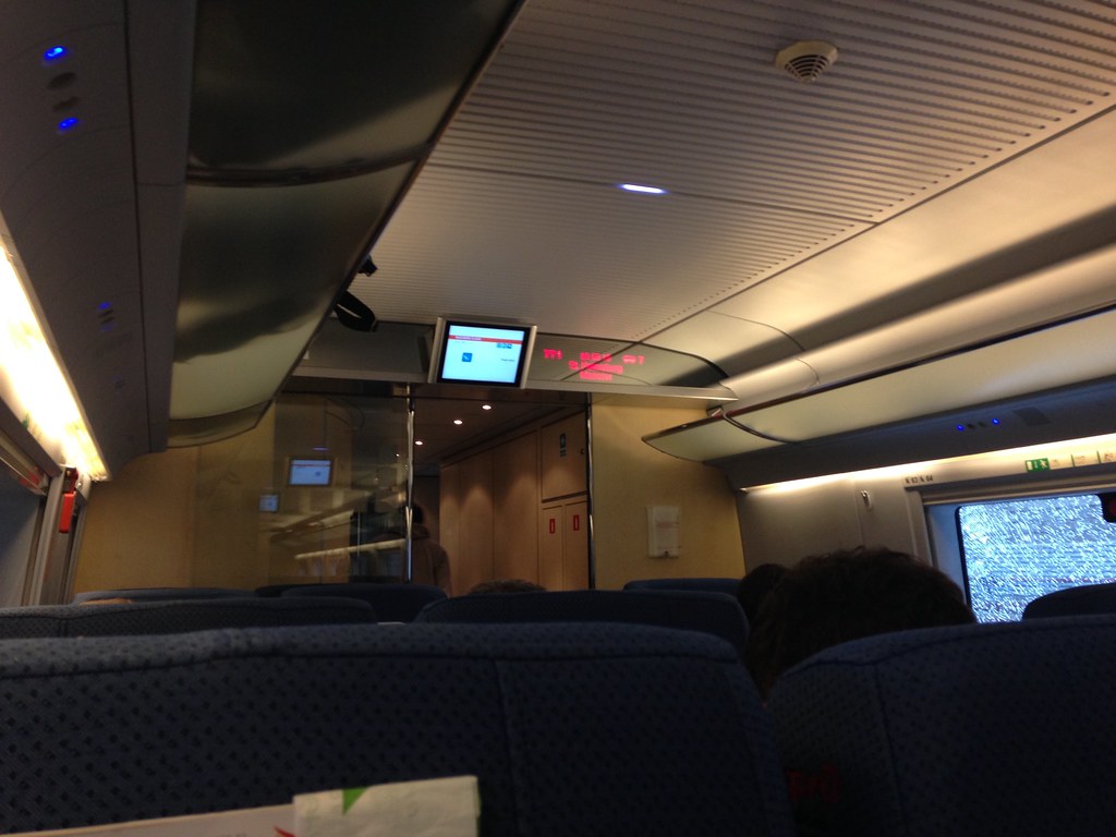
    St. Petersburg - August 2015

    An interior shot.

    St. Petersburg - August 2015

    Conclusion

    I hope this gives a bit of a feel for transport in Moscow. The city is obviously spending to try to upgrade its urban environment. Whether physical improvements in Moscow or elsewhere will survive Putin’s authoritarian turn is to be seen, but as the examples of the Moscow subway and many of the historic ruins we visit around the world show, it’s certainly possible for the cruelest of dictatorships to produce magnificent physical artifacts in select places. The success of these regimes should not be judged by that measure.

    In closing, I’ll leave translating the following as an exercise for the reader.

    Moscow - August 2015

    If you are interested, there’s an album of iPhone photos I took available on my Flickr page.

    Aaron M. Renn is a senior fellow at the Manhattan Institute and a Contributing Editor at City Journal. He writes at The Urbanophile, where this piece first appeared.

  • Moving to the London Exurbs and Beyond

    A review of the most recent internal migration (domestic migration) in England and Wales reveals some surprises. The latest data covers the one year ended June 30, 2014. It was published by the Office of National Statistics (ONS) and provides estimates at least down to the local authority area (municipality). In this regard, is positioned along with a number of European nations and the Australian Bureau of statistics well ahead of the US Census Bureau, which provides estimates only to the county level.

    The Regions

    On a regional level, there was little movement outside the southern half of England. England is divided into nine regions. Three of the northern and middle regions lost modest numbers of internal migrants, ranging from a minus 0.05% (minus 3,000 people) in the West Midlands, which contains England’s second largest city, Birmingham. There was loss of 0.06% (minus 7,100 people) in the North West, where Manchester and Liverpool are located. There was a 0.09% loss (minus 4,700 people) in Yorkshire and the Humber, where Leeds and Sheffield are located (Figure 1).

    The North East, which contains the city of Newcastle, has long been an area of economic hardship and is of danger of becoming "Britains Detroit" according to  The Guardian. Yet the North East experienced a small gain of 0.01% in internal migrants (500 people). The largest gain outside southern England was in the East Midlands, which includes Leicester and Nottingham, attracted a net 0.13 percent in new migrants (6,200 people). Wales (largest city Cardiff) also had a 0.1% gain in internal migrants (200 peopled).

    London (the Greater London Authority) lost by far the largest percentage of its population to internal migration, at minus 0.82 percent, or 68,600 people. This may be particularly surprising because London has recently reached its all-time population peak, having exceeded its pre-World War II 1939 estimated level. Yet virtually all of London’s huge population gain has been from natural growth (births minus deaths) and international migration. In recent years, this growth stems from strong gains in migration from a European Union countries, between which there is virtually unrestricted immigration.

    But Londoners, whether born in Great Britain or those who arrived before 2013, have been moving in large numbers to the exurbs beyond the greenbelt for some time and even farther away. The two large exurban regions have attracted many migrants. The East, which includes such well-known localities as Cambridge, Luton, Milton Keynes and St. Albans added the 0.33 percent to its population through internal migration. The South East, which includes localities like Oxford, Windsor, Dover and the entrance to the Euro tunnel to France added a somewhat smaller 0.23 percent.

    But some Londoners appear to be moving even farther away. The largest growth was in the South West region, which lies at least 70 miles (125 kilometers) from Trafalgar Square in London. The South West is home to such places as Bristol, Bath, Salisbury and Cornwall. The South West added 0.48 percent to its population through.

    London and Environs

    During 2013-2014, the dominant trend was movement away from London to the exurbs and regions just beyond the exurbs, with a less dominant trend away from the balance of England and Wales. Virtually all the internal migration growth was in the London Exurbs (East and South East) and the adjacent areas, the South West, East Midlands and West Midlands (Figure 2). Nearly all the loss was in London. Inner London, suffered the largest domestic migration loss, at 1.05 percent of its population (minus 35,000). Inner London, at 3.3 million remains well below its population peak of 4.5 million, reached nearly 115 years ago (1901). Outer London, consisting of the large tracts of semidetached and detached housing built in the inter-war years lost a smaller 0.66 percent of its population to internal migration (minus 33,700). Outer London now has a population of approximately 5.1 million, one-half larger than Inner London.

    The Office for National Statistics (ONS) explains that London attracts internal migrants up to age 29. But, the internal outmigration of people 30 and above more than cancels this out. ONS explains:

    "A key factor for people in their 30s and 40s who move out of London could be the cost of housing. Young couples wishing to buy their first house, or a larger one for a growing family, may find prices in London prohibitively expensive and therefore choose to live outside of London."

    ONS adds:

    "Another important reason may be that people with children are more likely to move out of London because of environmental or social factors. For example, they may be seeking somewhere greener and quieter, and may also perceive that a less urban neighbourhood offers a better social and educational environment for children. Moves of adults with children also explains why there is a net outflow of children from London."

    ONS further indicates that there is net migration from London of older citizens, including those over 90 (the highest age category reported upon). These are trends similar to those we have identified in the United States some of which were opposite the conventional wisdom (See: Driving Farther to Qualify in Portland, Urban Core Millennials? A Matter of Perspective, Exodus of the School Children, and Seniors Dispersing Away from the Urban Cores)

    Greatest Gains and Losses

    Even so, London had one local authority area with the greatest internal migration gain: the historic City of London. However, this area, which is the core of the central business district, has few residents. Even after the internal migration gain (1.80 percent), the city still has fewer than 8,000 residents. The other largest gainers in numbers were found in the London exurbs or the South West, with the exception of Fylde, which is located in Lancashire (the North West), adjacent to the resort of Blackpool.

    London had nine of the 10 local authority areas with the greatest internal migration losses (out of 348). The largest loss was in the inner London borough of Newham (minus 2.68%). The one non-London local authority area in the bottom 10 was Pendle, in Lancashire (the North West).

    Metropolitan Areas

    Only one of the larger metropolitan areas experienced a net internal migration gain. The Bristol – Bath area (ceremonial Avon County), located in the South West gained 0.25 percent (Figure 3).

    Two metropolitan areas that have long experienced serious economic declines suffered only modest losses. Newcastle (Tyne and Wear Metropolitan County) lost only 0.2 percent of its population to internal migration. Liverpool, with a central municipality that dropped from a population of 856,000 in 1931 to 439,000 in 2001 (after which modest growth returned), had an internal migration loss of 0.03 percent. Sheffield (South Yorkshire Metropolitan County) lost 0.08% of its population to net internal migration.

    In view of the relative fortunes of London and Liverpool over the last century, it is especially surprising that the London region, including the exurbs, lost internal migration at a rate four times that of Liverpool (0.13%).

    Manchester (Greater Manchester Metropolitan County) experienced a net internal migration loss of 0.17 percent, and Leeds-Bradford (West Yorkshire Metropolitan County). Birmingham (West Midlands Metropolitan County) have the greatest loss at -0.22 percent.

    More Dispersion

    By far the largest net internal migration numbers are in the south of England, reflecting strong trends of decentralization away from London, to the East and the South East. But, by far the largest recipient of internal migration is the South West, beyond even the exurbs. This is another confirmation of the dispersing pattern of development, as has been observed in virtually all of the world’s megacities.

    ————–

    Note: The United Kingdom does not formally designate metropolitan areas. This article uses metropolitan and former (ceremonial) counties to approximate metropolitan areas.

    Photograph: Local authority of Milton Keynes, Buckinghamshire (South East of England), by author

    Wendell Cox is Chair, Housing Affordability and Municipal Policy for the Frontier Centre for Public Policy (Canada), is a Senior Fellow of the Center for Opportunity Urbanism (US), a member of the Board of Advisors of the Center for Demographics and Policy at Chapman University (California) and principal of Demographia, an international public policy and demographics firm.

    He is co-author of the "Demographia International Housing Affordability Survey" and author of "Demographia World Urban Areas" and "War on the Dream: How Anti-Sprawl Policy Threatens the Quality of Life." He was appointed to three terms on the Los Angeles County Transportation Commission, where he served with the leading city and county leadership as the only non-elected member. He served as a visiting professor at the Conservatoire National des Arts et Metiers, a national university in Paris. 

  • Book Review: Designed For The Future by Jared Green

    By the fifth word of Designed for the Future, Jared Green had almost lost me. By the end, he hadn’t quite gained me. This slim, visually interesting handbook presents “80 practical ideas for a sustainable world” from the noted author of The Dirt, a weekly blog sponsored by the American Society of Landscape Architects. Green’s earnest mission is to find hope for the future, and with this book, he edits a collection of essays that points to some projects that do.

    It is a slim, portable, affordable book for the busy design professional in any discipline who is trying to wrap his or her head around the slippery notion of sustainability. Green’s introduction summarizes his process, and then presents each idea in a two-page spread. The ideas range from using mushrooms, which are now compressed into insulation panels (don’t eat your wall), to Rome as an example of walkable urbanism (don’t tell the taxi drivers). Each idea is presented with a photograph and a neat summary of how it contributes to the future. The point of all this activity, however, remains elusive in this otherwise intriguing little book.

    Designed For the Future poses the question to eighty thinkers: “What gives you hope that a sustainable future is possible?” Each replies with a brief description of a project that inspired them to see a way forward. Among the notable but not entirely successful attempts to provide an answer is an essay by Elizabeth Mossop, “Changing Course,” about a design competition to improve management of the Lower Mississippi River in Louisiana. She notes that up until now the river, managed by scientists and engineers, has lost wetlands and added pollution to the Gulf of Mexico. Giving designers a turn might be a good idea, as she suggests. While I’m sympathetic, I keep thinking of the woeful mismanagement of the Everglades in my home state of Florida, and how often well-intentioned healing practices seem forever delayed. It is as if we cannot collectively bring ourselves to veer off our current pathway, no matter who is in charge.

    Some essays, however, are the real thing. “Project Row Houses” by F. Kaid Benfield showcases artist Rick Lowe’s community development project to preserve 22 wood-frame shotgun homes in Houston. The project uses buildings that are already built, improving them rather than replacing them; it provides dignified shelter for historically disadvantaged African Americans, and has spawned urban agriculture, education, and similar enterprises. This is what sustainability should be all about: taking our stuff and making it better, rather than abandoning it and making more stuff.

    Many of the essays are somewhat predictable paeans to urban life. “Seven Dials,” by New Urbanist Victor Dover, extols the virtues of this tiny London street intersection and its surroundings. Developed in the seventeenth century, this West End neighborhood has gentrified nicely into a walkable community. The accompanying photo seems too good to be true: pedestrians actively engaged in their public realm, not a car in sight, the sundial festooned with Union Jacks. As a prosperous, white, upper-middle-class community, it is an easy example of the urbanist’s dream come true, but well nigh impossible to replicate in America’s big-box car culture. Perhaps it could survive as a simulated city somewhere.

    Green’s inclusion of an analysis by Anthony Flint of Unité d’Habitation inspired me. This 11-story apartment block, built in France after World War II, lets daylight in on both sides of each apartment,, and features rooftop uses. It was architect Le Corbusier’s first phase of his Radiant City plan. The design was much maligned in the 1990s by urban activists as a misanthropic disaster, who claimed that traditional neighborhoods were better. But the Unite d’Habitation turned out to be a pretty nice place after all, while many well-intended traditional neighborhood developments have had poor results. There is hope, after all, for modernism.

    Green’s second-to-last entry is an essay on vernacular architecture by Li Xiaodong, a Beijing architect and professor at Tsinghua University School for Architecture. In some ways, this is the book’s most important essay. “It’s about the process, not about design,” says Li, adding, “Architecture should be based in a dialogue with local conditions and lifestyles. It should be a product of that dialogue.” Li beautifully captures the essence of sustainability, seeing it as a thought process, not a look or a lifestyle; about reacting intelligently to local conditions with materials and labor available on hand.

    Green’s examples are heavy on the land planning side of things. Innovations such as 3-D printing are missed, and economics and technology are entirely ignored. And a few essays seem repetitive: Paris is in the book twice.

    The focus is on people, land, water, and air. Reducing pollution and waste are important, and his book illustrates examples of this in abundance. We seem to have bounced back from the bad old days of the Ohio River on fire and air so thick you can take a bite out of it. This book offers assurance we are not backsliding into the wicked ways of the past.

    Reducing the amount of stuff we take from the earth also figures big. Densifying cities, which conserves open space, is the topic of more than one essay. Staying local and using renewable, vernacular materials also has resonance with these contributors. Green’s essayists portray a future where resources are extracted a little more gingerly, and open land is conserved and even integrated into human habitation on a small scale to improve our relationship with nature.

    The classical definition of sustainability includes two other tenets: increasing biodiversity, and spreading a little justice around to other species. The book provides scant evidence that the future holds any hope for these two notions. The wind farm in Lester Brown’s “Wind Mega Complexes” essay even goes against these principles, showcasing the giant wind turbines blamed for bird kills. Regarding biodiversity, Green misses the Mesoamerican Biological Corridor project, an oversight perhaps due to his self-proclaimed “random process” for choosing contributors.

    Green begins the book with the statement, “We can’t give in to fatalism.” For the symptoms of fatalism, he presents examples of cures. Someone, somewhere, is treating these symptoms, he reassures us, saying that things are getting better in many different ways.

    A deeper disease, however, lies undiagnosed in this book. Cities are denser, yes; but they increasingly all look the same. Wetlands are saved, yes; but we continue to “manage” them, as if it would be awful if they were left to themselves. Just when public spaces are getting nicer, most Americans prefer to remain indoors, glued to their devices. None of these imply a future of abundance and beauty. Until our own meaning and purpose are more fully addressed by our present society, it seems difficult to conceive of the kind of future envisaged in Designed For the Future.

    Richard Reep is an architect with VOA Associates, Inc. who has designed award-winning urban mixed-use and hospitality projects. His work has been featured domestically and internationally for the last thirty years. An Adjunct Professor for the Environmental and Growth Studies Department at Rollins College, he teaches urban design and sustainable development; he is also president of the Orlando Foundation for Architecture. Reep resides in Winter Park, Florida with his family.

  • The Changing Patterns Of U.S. Immigration: What The Presidential Field Should Know, And You

    Public concern about illegal immigration, particularly among older native-born Americans, as well as the the rising voting power of Latinos, all but guarantees that immigration is an issue that will remain at the forefront in the run-up to the 2016 elections. Nor is this merely a right-wing issue, as evidenced in the controversy over “sanctuary cities”; even the progressive Bernie Sanders has expressed concern that massive uncontrolled immigration could “make everybody in America poorer.”

    Yet despite the political heat, there is precious little dispassionate examination of exactly where immigrants are coming from, and where in the U.S. they are headed. To answer these questions, we turned to demographer Wendell Cox, who analyzed the immigration data between 2010 and 2013 for the 52 metropolitan statistical areas with populations over a million.

    One would think listening to the likes of Donald Trump that the country is awash with hordes of unwanted newcomers from Mexico and Central America. But sorry, Donald, the numbers show a changing picture in terms of who is coming, as well as the places that they choose to settle.

    Perhaps due to Mexico’s stronger economy and lower birthrates, Mexicans are no longer as dominant in the ranks of new immigrants as in the last decade. Mexico is still the single largest place of origin of new immigrants, but from 2010 through 2013, Mexican migration to the U.S. dropped 17.7% to an average of 140,266 a year, according to data from the U.S. Department of Homeland Security. Meanwhile the inflow from Asia has increased: immigration from China is up 25.8% to 74,458 a year, and 10.7% from India to 65,336 a year. Asia now equals the Americas as a source of new immigrants, with each accounting for 40% of the annual total.

    European immigration, once the mainstay of growth for the U.S., fell 32% from 2010 to 2013 to an average of 91,000 a year, surpassed by the number of African immigrants, which has soared 29.6% to 98,000 annually.

    America’s new African population tends to be well-educated — considerably more than the national average: they are more than 60% more likely to have a graduate degree than other Americans. The vast majority are fluent in English and fully one-third hold management or professional level jobs. Not surprisingly, they are generally doing well in their new country. The places where they settle — notably New York, greater Washington, Houston and Dallas-Fort Worth — will likely benefit from their presence in coming years.

    Just as Mexican and Asian immigration changed the ethnic geography of America, boosting economies and changing local culture, one can expect the Africans to do much the same in the coming years.

    The Largest And Fastest-Growing Immigrant Hubs

    The largest foreign-born communities in America reflect both size and longstanding immigrant populations. The leader remains the New York metropolitan statistical area, which was home in 2013 to 5.69 million people born elsewhere, following by Los Angeles with 4.3 million, Miami with 2.2 million, Chicago with 1.69 million and Houston with 1.39 million.

    But a look at the metro areas with the fastest-growing foreign-born communities tells a different story, one of growing migration into the more interior and central parts of the country. In many ways, this reflects the attraction of areas with relatively low housing prices and buoyant local economies. In contrast, the economies of many traditional immigrant hubs like Los Angeles and Chicago have not done so well, while places in coastal California and near New York suffer from high housing prices.

    Pittsburgh ranks first for recent pace of growth, with a 17.4% jump in its foreign-born population to 89,000 from 2010 through 2013, almost four times the 4.3% national rate over the same span. The western Pennsylvania city has built a robust economy based on energy, medical services and technology. Its housing prices are low — roughly a third those of the Bay Area based on median income — and the city is situated in an attractive setting with rolling hills. Pittsburgh is attracting both less educated immigrants from more expensive places, and also educated newcomers, notes demographer Jim Russell, some due to the strong universities in the area.

    Other surprising heartland destinations for immigrants include Indianapolis, whose foreign-born population expanded 14.3% in 2010-13 to 127,767, the second fastest rate of growth among the largest metro areas; Oklahoma City (third fastest, up 12.9% to 110,269); and Columbus, Ohio (up 9.8% to 139,562). Generally, these cities, like Pittsburgh, have strong economies, low housing prices and favorable state regulatory climates.

    The Move South Continues

    Until the 1970s, the South was an also-ran in immigration, with the exception of Florida. But today many of the fastest-growing foreign-born communities are in the South. These include still-recovering New Orleans, whose numbers of foreign born surged 12.4% in 2010-13 to 91,412, as well as Charlotte (up 11.2% to 225,673) and Austin (up 10.7% to 279,923).

    This  movement to the South in recent decades has changed the geography of the most immigrant rich parts of the country. Three of the 10 metro areas with the largest number of foreign born residents are in the south. Miami has some 2.26 million immigrant residents make  up with 38.8% of its population, the highest proportion of any large metro area in the country. The Houston metro area has the fifth biggest foreign-born population, Dallas-Ft. Worth, the eighth.

    The Texas metro areas, and their emerging southern counterparts, offer much of what the prospering Rust Belt cities also provide — strong broad-based economies and an affordable cost of living, particularly housing. Immigrants tend to prioritize home ownership and often work in thriving blue-collar fields such as manufacturing , logistics and construction.

    Coastal Growth Follows The Economy

    The Atlantic and Pacific coasts have long dominated immigration, but there appears to be some subtle changes in this picture. Most big coastal metro areas have logged steady but below average growth of their foreign-born populations, including New York, with a 3.67% increase. (Note that even with relatively slow growth in percentage terms, New York added a net 208,800 immigrants, more than the total foreign-born populations of any of the four fastest growers.) Some blue areas are doing much better in terms of growth rate, including Seattle (9th), Boston (11th) and San Jose (15th). All tend to be expensive, but have done very well in the recovery, largely due to technology-related growth.

    In contrast, some traditional immigrant hubs with weaker economies have lagged behind. Chicago’s foreign-born population increased 1.71%, less than half the national average. Los Angeles’ foreign born population ticked down 0.1% amid economic stagnation and rising housing prices. When it comes to immigration, it is the geography of opportunity that still prevails.

    U.S. Metropolitan Areas with the Highest Share of Immigrants

    No. 1: Miami, Fla.

    Number of Foreign-Born: 2.26 million

    Percentage of Population, 2013: 38.8%

    No. 2: San Jose, Calif.

    Number of Foreign-Born: 719,460

    Percentage of Population, 2013: 37.5%

    No. 3: Los Angeles, Calif.

    Number of Foreign-Born: 4.39 million

    Percentage of Population, 2013: 33.2%

    No. 4: San Francisco, Calif.

    Number of Foreign-Born: 1.34 million

    Percentage of Population, 2013: 29.7%

    No. 5: New York, NY-NJ-PA

    Number of Foreign-Born: 5.69 million

    Percentage of Population, 2013: 28.5%

    No. 6: San Diego, Calif.

    Number of Foreign-Born: 761,580

    Percentage of Population, 2013: 23.7%

    No. 7: Houston, Tex.

    Number of Foreign-Born: 1.42 million

    Percentage of Population, 2013: 22.6%

    No. 8: Washington, D.C.

    Number of Foreign-Born: 1.31 million

    Percentage of Population, 2013: 22.0%

    No. 9: Las Vegas, Nev.

    Number of Foreign-Born: 440,866

    Percentage of Population, 2013: 21.7%

    No. 10: Riverside-San Bernardino, Calif.

    Number of Foreign-Born: 932,747

    Percentage of Population, 2013: 21.3%


    This piece first appeared in Forbes.

    Joel Kotkin is executive editor of NewGeography.com and Roger Hobbs Distinguished Fellow in Urban Studies at Chapman University, and a member of the editorial board of the Orange County Register. He is also executive director of the Houston-based Center for Opportunity Urbanism. His newest book, The New Class Conflict is now available at Amazon and Telos Press. He is also author of The City: A Global History and The Next Hundred Million: America in 2050. He lives in Orange County, CA.

    Photo by telwink

  • The Peril to Democrats of Left-Leaning Urban Centers

    Twenty years ago, America’s cities were making their initial move to regain some of their luster. This was largely due to the work of mayors who were middle-of-the-road pragmatists. Their ranks included Rudy Giuliani in New York, Richard Riordan in Los Angeles, and, perhaps the best of the bunch, Houston’s Bob Lanier. Even liberal San Franciscans elected Frank Jordan, a moderate former police chief who was succeeded by the decidedly pragmatic Willie Brown.   

    In contrast, a cadre of modern mayors is minting a host of ideologically new urban politics that put cities at odds with millions of traditional urban Democrats. This trend is strongest on the coasts, but is also taking place in many heartland cities. Bill de Blasio is currently its most prominent practitioner, but left-wing pundit Harold Meyerson says approvingly that many cities are busily mapping “the future of liberalism” with such policies as  the $15-an-hour minimum wage, stricter EPA greenhouse gas regulations, and housing policies intended to force people out of lower density suburbs and into cities.

    For the Democrats, this urban ascendency holds some dangers. Despite all the constant claims of a massive “return to the city,” urban populations are growing no faster than those in suburbs, and, in the past few years, far slower than those of the hated exurbs. This means we won’t see much change in the foreseeable future in the current 70 to 80 percent of people in metropolitan America who live in suburbs and beyond. University of Washington demographer Richard Morrill  notes that the vast majority of residents of regions over 500,000—roughly 153 million people—live in the lower-density suburban places, while only 60 million live in core cities.  

    This leftward shift is marked, but it’s not indicative of any tide of public enthusiasm. One-party rule, as one might expect, does not galvanize voters. The turnout  in recent city elections has plummeted across the country, with turnouts 25 percent or even lower. In Los Angeles, the 2013 turnout that elected progressive Eric Garcetti was roughly one-third that in the city’s 1970 mayoral election.

    Bolstered by this narrow electorate, liberal pundits celebrate the fact that 27 of the largest U.S. cities voted Democratic in 2012, including “red” state municipalities such as Houston — but without counting the suburbs, where voter participation tends to be higher. An overly urban-based party faces the same fundamental challenges of a largely rural-oriented one—for example, the right-wing core of the GOP—in a country where most people live in neither environment.

    Demographic and Political Transformation of American Cities

    City dwellers have historically voted more liberally than their country or suburban cousins, but demographic trends are exacerbating this polarizing impulse. Simply put, the cities that could elect a Giuliani or a Riordan no longer exist. The centrist urban surge of the 1990s was both a reaction to the perceived failures of Democratic “blue” policies as well a reflection of the makeup of white-majority, middle-class neighborhoods in places like Brooklyn, Queens and the San Fernando Valley that featured healthy numbers of politically moderate “Reagan Democrats”—or Bill Clinton Democrats, circa 1992

    Since then, these communities have been largely supplanted by groups far more likely to embrace a more progressive political stance: racial minorities, hipsters, and upper-class sophisticates. These groups have swelled, and gotten much richer, in places like brownstone Brooklyn  or lakeside Chicago, while the number of inner city middle-class neighborhoods, as Brookings  has demonstrated, have declined, to 23 percent of the central city—half the level in 1970.

    This new urban configuration, notes the University of Chicago’s Terry Nichols Clark, tend to have different needs, and values, than the traditional middle class. Since their denizens are heavily single and childless, the poor state of city schools does not hold priority over the political power of the teachers unions. The key needs for the new population, Clark suggests, are good restaurants, shops and festivals, not child-friendly parks and family-oriented stores. Sometimes even crazy notions—such as allowing people to walk through the streets of San Francisco naked—are tolerated in a way no child-centric suburb would allow.

    These tendencies underscore as well the increasingly homogeneous political culture emerging in cities. In 1984, for example, Ronald Reagan took 31 percent of the vote in San Francisco, and 37 percent in New York. He actually carried Los Angeles. By 2012, a Republican with a more moderate history could not muster 20 percent of the vote in San Francisco. And Mitt Romney lost Los Angeles by more than a 2-1 margin, while garnering barely 20 percent in all New York boroughs besides Staten Island.

    Economic Hubris

    These changes also reflect a shift in the economic role of cities. Until the 1970s, cities were centers of production, distribution and administration. Then the industrial base of urban areas, and related jobs such as logistics, began moving away from the traditional manufacturing cities  to overseas, the suburbs or the Southeast.  In 1950 New York, according to economic historian Fernand Braudel, 1 million people worked in factories, mostly for small companies. Today the city’s industrial workforce now stands at a paltry 73,000, a dramatic decline from some 400,000 as recently as the early 1980s.

    A similar, if less spectacular, decline has taken place in what are still the two largest industrial metropolitan statistical areas, Chicago and Los Angeles. The one-time “City of Big Shoulders” and its environs had 461,600 industrial jobs in 2009. Today it has fewer than 300,000. Los Angeles, in a process that started with the end of the Cold War, has seen its once-diverse industrial base erode rapidly, from 900,000 just a decade ago to 364,000 today. 

    In some cities, a new economy has emerged, one that is largely transactional and oriented to media. The upshot is that denizens of the various social media, fashion and big data firms have little appreciation of the difficulties faced by those who build their products, create their energy and food. Unlike the factory or port economies of the past, the new “creative” economy has little meaningful interaction with the working class, even as it claims to speak for that group.

    This urban economy has created many of the most unequal places  in the country. At the top are the rich and super-affluent who have rediscovered the blessings of urbanity, followed by a large cadre of young and middle-aged professionals, many of them childless. Often ignored, except after sensationalized police shootings, is a vast impoverished class that has become ever-more concentrated in particular neighborhoods. During the first decade of the current millennium, neighborhoods with entrenchedurban poverty actually grew, increasing in numbers from 1,100 to 3,100. In population, they grew from 2 million to 4 million.Some 80 percent of all population growth in American cities, since 2000, notes demographer Wendell Cox, came from these poorer people, many of them recent immigrants.

    Such social imbalances are not, as is the favored term among the trendy, sustainable. We appear to be creating the conditions for a new wave of violent crime on a scale not seen since the early 1990s. Along with poverty, public disorderlinessgang activityhomelessness and homicides are on the rise in manyAmerican core cities, including Baltimore, Milwaukee, Los Angeles and New York. Racial tensions, particularly with the police, have worsened. So even as left-leaning politicians try to rein in police, recent IRS data in Chicago reveals, the middle class appears to once again be leaving for suburban and other locales. 

    Urbanity and Politics

    These social and economic changes inform the new politics of the Democratic Party. On social policy, the strong pro-gay marriage and abortion positions of the Democrats makes sense as cities have the largest percentages of both homosexuals and single, childless women. When the party had to worry about rural voters in South Dakota or West Virginia, this shift would have been more nuanced, and less rapid.

    Yet with those battles essentially won, the new urban politics are entering into greater conflict with the suburban mainstream, which tends to be socially moderate, and even more so with the resource-dependent economies of rural America. The environmental radicalism that has its roots in places like San Francisco and Seattle  now directly seeks to destroy whole parts of middle America’s energy economy.

    Such policies tend to radically raise energy costs. In California, the green energy regime has already driven roughly 1 million people, many of them Latinos in the state’s agricultural interior, into “energy poverty”—a status in which electricity costs one-tenth of their income. Not surprisingly, those leaving California, notes Trulia, increasingly are working class; their annual incomes in the range of $20,000 to $80,000 are simply not enough to make ends meet.

    Geography seems increasingly to determine politics. Ideas on climate policy that seem wonderfully enlightened in Manhattan or San Francisco—places far removed from the dirty realities of production—can provide a crushing blow to someone working in the Gulf Coast petro-chemical sector or in the Michigan communities dependent on auto manufacturing.

    It’s more than suburban or rural jobs that are on the urban designer chopping block. Density obsessed planners have adopted rules, already well advanced in my adopted home state of California, to essentially curb  much detested suburban sprawl and lure people back to the dense inner cities. The Obama administration is sympathetic to this agenda, and has adopted its own strategies to promote “back to the city” policies in the rest of the country as well.

    But as these cities go green for the rich and impressionable, they must find ways to subsidize the growing low-paid service class—gardeners, nannies, dog walkers, restaurant servers—that they depend on daily. This makes many wealthy cities, such as Seattle or San Francisco, hotbeds for such policies as a $15-an-hour minimum wage, as well as increased subsidies for housing and health care. In San Francisco, sadly, where the median price house (usually a smallish apartment) approaches  $1 million, a higher minimum wage won’t purchase a decent standard of living. In far more diverse and poorer Los Angeles, nearly half of all workers would be covered — with unforeseen impacts on many industries, including the largegarment industry.

    These radicalizing trends are likely to be seen as a threat to Democratic prospects next year, but instead will meet with broad acclaim among city-dominated progressive media. Then again, the columnists, reporters and academics who embrace the new urban politics have little sympathy or interest in preserving middle-class suburbs, much less vital small towns. If the Republicans possess the intelligence—always an open question—to realize that their opponents are actively trying to undermine how most Americans prefer to live, they might find an opportunity far greater than many suspect.

    This piece first appeared at Real Clear Politics.

    Joel Kotkin is executive editor of NewGeography.com and Roger Hobbs Distinguished Fellow in Urban Studies at Chapman University, and a member of the editorial board of the Orange County Register. He is also executive director of the Houston-based Center for Opportunity Urbanism. His newest book, The New Class Conflict is now available at Amazon and Telos Press. He is also author of The City: A Global History and The Next Hundred Million: America in 2050. He lives in Orange County, CA.

    Photo by Kevin Case from Bronx, NY, USA (Bill de Blasio) [CC-BY-2.0], via Wikimedia Commons

  • Progressive Policies Drive More Into Poverty

    Across the nation, progressives increasingly look at California as a model state. This tendency has increased as climate change has emerged as the Democratic Party’s driving issue. To them, California’s recovery from a very tough recession is proof positive that you can impose ever greater regulation on everything from housing to electricity and still have a thriving economy.

    And to be sure, the state has finally recovered the jobs lost in the 2007-09 recession, largely a result of a boom in values of stocks and high- end real estate. Things, however, have not been so rosy in key blue-collar fields, such as construction, which is still more than 200,000 jobs below prerecession levels, or manufacturing, where the state has lost over one-third of its employment since 2000. Homelessness, which one would think should be in decline during a strong economy, is on the rise in Orange County and even more so in Los Angeles.

    The dirty secret here is that a large proportion of Californians, roughly one-third, or some 3.2 million households, as found by a recent United Way study, find it increasingly difficult to keep their heads above water. The United Way study, surprisingly, has drawn relatively little interest from a media that usually enjoys highlighting disparities, particularly racial gaps. Perhaps this reflects a need to maintain an illusion of blue state success. If Republican Pete Wilson were still governor, I suspect we might have heard much more about this study.

    Read the entire piece at The Orange County Register.

    Joel Kotkin is executive editor of NewGeography.com and Roger Hobbs Distinguished Fellow in Urban Studies at Chapman University, and a member of the editorial board of the Orange County Register. He is also executive director of the Houston-based Center for Opportunity Urbanism. His newest book, The New Class Conflict is now available at Amazon and Telos Press. He is also author of The City: A Global History and The Next Hundred Million: America in 2050. He lives in Orange County, CA.

  • The Really Big Housing Picture

    Everywhere I go it seems there’s some kind of housing crisis. In some places home values are dropping precipitously, people are unable to sell and move on, and formerly middle class homes are being abandoned or converted to poorly maintained rental properties. In other places home values and rents are obscenely high and ordinary people and essential workers are being driven out of whole cities and counties. The national economy has bifurcated and the shrinking middle class is reflected in a two tiered housing market. I’d like to explore the root causes of the situation.

    Woodstock-kidsWikipedia

    Reagan_et_ThatcherWikipedia

    Our current real estate schism is based on two forces. First, we as a society decided decades ago that we didn’t want to be shackled by the social conventions and obligations that hindered individuals in their quest for personal fulfillment and private gain.

    For liberals this took the form of women’s liberation, black liberation, gay liberation… Everyone wanted to throw off the yoke of conformity. For conservatives it took the form of tax revolts, rebellions against regulations of every kind, a search for open space, cheap labor, and new markets.

    These two groups were in no way mutually exclusive. Both the California Hippy and Evangelical Christian from South Carolina were pushing the country in the same direction for decades whether they knew it or not. Everyone was rebelling against social constraints and dismantling the old system that created the broad stable middle class in the first place.

    Screen Shot 2015-07-23 at 9.05.36 PM

    Screen Shot 2015-07-23 at 8.59.17 PM

    Screen Shot 2015-07-23 at 9.06.57 PM

    Screen Shot 2015-07-23 at 9.16.12 PM

    The second force in the housing crisis is based on physical mobility made possible by car culture, affordable commercial aviation, containerized cargo shipping, and modern telecommunications. Geography stopped being a material limitation for the last few generations. As a result, people have self segregated. The rich have congregated in a handful of premium locations and radically driven up the cost of living in those spots. The poor have been left to their own devices in economically and culturally abandoned regions. And the ever diminishing middle class has leveraged itself into a thousand little niches in an attempt to keep up as their incomes and status decline.

    Screen Shot 2015-06-12 at 1.16.04 AM

    Screen Shot 2015-06-12 at 6.52.37 PM

    I was recently at a meeting in Northern California where government officials, local business people, and community organizers all gathered to promote their various objectives. These were all incredibly kind, decent, responsible people who truly cared about their town. The difficulties on hand will be familiar if you live in one of the more expensive parts of the country.

    There’s a desperate need for affordable housing. There’s huge pressure to preserve productive farmland and the natural landscape. There’s fierce NIMBYism that stops new growth of every kind. There’s serious money pressing down on the scarce property that is available. There’s a water shortage brought on by years of drought. And there simply is no culturally or politically tolerable mechanism to reconcile any of these conflicting forces. Honestly, for the people who already own property in the area the situation is pretty sweet – so long as the authorities manage to keep the ever growing homeless camps out of sight. The default setting is to simply let things fester and muddle through.

    Screen Shot 2015-03-18 at 1.26.28 AM

    Screen Shot 2015-03-10 at 5.31.42 PM

    Screen Shot 2015-03-12 at 2.10.06 AM

    Just a month earlier I was at a different meeting in another town where the problem was reversed. A formerly prosperous town was hitting an economic wall as growth and development had come to a complete halt with unpleasant consequences. There was plenty of cheap land all around and everyone was desperate to see it covered in new homes, shopping malls, and office parks as quickly as possible. But market demand evaporated. Developers couldn’t justify building much of anything because there were no buyers on hand. Too much of the existing building stock was already sitting vacant.

    You’d think these two problems could solve each other. Why don’t all the people desperate for affordable housing in one place simply move to the place with abundant vacancies? Of course, it doesn’t work that way. Communities are more than a pile buildings. People need the right mix of employment, education, culture, and so on. You can’t live in a cheap place if you have no access to jobs. And you can’t take a job in a place where there is no available housing.

    Screen Shot 2015-07-23 at 9.05.36 PM

    Let’s go over some of the particulars again. Mass motoring allowed almost everyone to move away from the things and people they didn’t like. If your taxes went up you moved away. If “undesirables” arrived on your block you moved away. If you didn’t like the snow you moved away. Cheap private transportation on America’s highways made it possible for the vast 20th century middle class to remove itself from traditional communities and find bliss is splendid isolation.

    Screen Shot 2015-07-23 at 8.59.17 PM

    Affordable commercial aviation let people migrate to previously remote locations. A car could get you from New Jersey to Florida in a couple of days, but a plane could get you there in a couple of hours. Air transport preferentially poached the affluent, the young, the educated, and retirees from established towns and delivered them to previously obscure destinations. The ability to hop quickly and cheaply from place to place was a tremendous boon to some lucky towns, but the death knell to others.

    Screen Shot 2015-07-23 at 9.06.57 PM

    Containerized shipping brought raw materials and cheap manufactured goods in from every corner of the globe. If workers threatened to strike you moved your company away. Far away. If you found a better tax deal you moved away. If you needed the authorities to turn a blind eye to your company’s waste stream you moved away. The toaster ovens, refrigerators, and steel belted radial tires could all be made somewhere else for a lot less money.  And along with those jobs went a big chunk of the old middle class.

    Screen Shot 2015-07-23 at 9.16.12 PM

    Information technology has added a new layer of mobility to the population. It’s now possible to use your mobile phone to turn your home air conditioner on and off from six thousand miles away. On the one hand this sort of technological magic allows millions of people to earn a living remotely. An accountant from Albuquerque can live in a beach cabin in Hawaii while still drawing her livelihood from New Mexico.

    On the other hand, what happened to blue collar jobs in the past is now happening to white collar jobs. Your CT scan or X-rays can now be sent via the Internet to a technician in the Philippines who will interpret your medical condition remotely. Film editing can be done entirely online from Brazil. Computer code can be written in India. Architectural and engineering work can be done digitally in the Ukraine. If a job can be scanned, or Skyped, or pushed through a fiber optic wire somehow it will eventually be sent to a low wage region to be done by someone who is smarter, faster, and more desperate for work than you are.

    And this isn’t factoring in the jobs that will soon be done entirely by machine intelligence. That accountant in Hawaii needs to pay attention to what she’ll do when her clients all switch to the cheaper advanced computer program that can wiggle around the tax code better than she can. Then again, the guy who writes that computer code will become very rich and might be able to move to Hawaii himself.

    unnamed-5

    unnamed-3

    unnamed

    So what are the options here? First, we can allow the already stressed middle class to continue to shrink so that the U.S. becomes a two tiered society of haves and have nots – with many more losers than winners. Inevitably this will require an increase in both government police and private security to keep the wealthy protected from the pissed off impoverished masses. There are plenty of examples of what that looks like around the world.

    Or, we could tax the rich and redistribute the funds to the formerly middle class population that has trouble feeding itself and keeping a roof over their heads. We also know what that looks like.

    Or we could create a new social, political, and economic national compact that restructures absolutely everything. Some old fashioned societal constraints might be a prerequisite for equity and a renewed middle class. Rights come with responsibilities. Aging Baby Boomers will fight that sort of thing tooth and nail. But Millennials will likely grab at it with both hands. Toss in fuel supply disruptions and a break down in international trade relations and American society might find itself coalescing in very different ways.

    John Sanphillippo lives in San Francisco and blogs about urbanism, adaptation, and resilience at granolashotgun.com. He’s a member of the Congress for New Urbanism, films videos for faircompanies.com, and is a regular contributor to Strongtowns.org. He earns his living by buying, renovating, and renting undervalued properties in places that have good long term prospects. He is a graduate of Rutgers University.

  • More Local Decisions Usurped by Ideological Regulators

    In hip, and even not-so-hip, circles, markets, restaurants and cultural festivals across the country, local is in. Many embrace this ideal as an economic development tool, an environmental win and a form of resistance to ever-greater centralized big business control.

    Yet when it comes to areas being able to choose their urban form and for people to cluster naturally – localism is now being constantly undermined by planners and their ideological allies, including some who superficially embrace the notion of localism.

    In order to pursue their social and perceived environmental objectives, they have placed particular onus on middle- and upper-class suburbs, whose great crime appears to be that they tend to be the places people settle if they have the means to do so.

    Central planning

    Nothing is more basic to the American identity than leaving basic control of daily life to local communities and, as much as is practical, to individuals. The rising new regulatory regime seeks decisively to change that equation. To be sure, there is a need for some degree of regulation, notably for basic health and public safety, as well as maintaining and expanding schools, parks, bikeways and tree-planting, things done best when supported by local voters.

    Read the entire piece at The Orange County Register.

    Joel Kotkin is executive editor of NewGeography.com and Roger Hobbs Distinguished Fellow in Urban Studies at Chapman University, and a member of the editorial board of the Orange County Register. He is also executive director of the Houston-based Center for Opportunity Urbanism. His newest book, The New Class Conflict is now available at Amazon and Telos Press. He is also author of The City: A Global History and The Next Hundred Million: America in 2050. He lives in Orange County, CA.

    City Hall photo by Flickr user OZinOH.

  • Congratulations Boston!

    Congratulations Boston! Your rejection of the "honor" of representing the US as its candidate for the 2024 Summer Olympics is an inspiring example of government performing its obligation to taxpayers and their hard earned money. Those of us who think that government has a responsibility to wisely use taxpayer money sometimes forget that Massachusetts enacted Proposition 2 1/2 not long after California’s fabled Proposition 13.

    In an era of routinely wasteful government spending, Boston’s decision stands out as unusual. It rivals the courage of New Jersey Governor Chris Christie who cancelled a new Hudson River rail tunnel, mid-project, because of the consultants and builders seemed sure to take advantage of the blank check that New Jersey taxpayers were required to pledge. This, of course has been the record of major infrastructure projects all over the world and most recently one of the most grotesque examples was Boston’s own "Central Artery." But unlike “the Big Dig”. This time Boston didn’t have speaker Tip O’Neill to bring home the bacon. Then, the federal government capped its share and Boston had to pay it all. Unsurprisingly, the bill was much higher and had to be paid by Massachusetts, along with the interest on extra debt that had to be issued.

    Oxford University Professor Bent Flyvbjerg, who has become famous for his quality analysis of large infrastructure projects, especially urban rail projects, produced a report with Allison Stewart on the history of Olympics cost overruns between 1960 and 2012. The two worked under the auspices of the Said Business school of England’s at Oxford. They concluded:

    The data thus show that for a city and nation to decide to host the Olympic Games is to take on one of the most financially risky type of megaproject that exists, something that many cities and nations have learned to their peril.

    They found that every Olympic Games, summer or winter, for which complete data is available experienced cost overruns. The most recent, in London, experienced a cost overrun of 100 percent. Flyvbjerg and Steward used a very simple model that has been applied to the previous infrastructure work. They just looked at the final bill that included all the expenses.This was compared to the amount the sponsors and their funders, the taxpayers, were it was going to cost when the application was approved by the local political process.

    The principal problem was the Olympic Committee requirement that sponsors must ensure the financing of all major capital investment required and are "on the hook" for any cost overruns.

    Montréal’s legendary Mayor Jean Drupeau sold his city on an Olympics bid saying that "the Montréal Olympics and no more have a deficit that a man can have a baby." Well, men are not yet having babies, but Montréal gave birth to a world-class cost overrun in its 1976 summer Olympics.  According to Flyvbjerg and Stewart, the 1976 Montréal Olympics had a cost overrun of nearly 800 percent, nearly double the 1992 420 percent cost overrun of Barcelona. Montréal may have set a record for much more than the Olympics with its cost overrun.

    Things have been virtually as bad in Greece. The researchers reported that "Olympic cost overruns and debt have exacerbated" the Greek economic crisis.

    There has been one exception to this sorry record. Los Angeles, host of the 1984 summer Olympic Games, actually turned a profit, sending more than $300 million to the international Olympic Committee and using the local profits for the LA84 Foundation, which funds youth sports and related activities, even 30 years after the event.

    I coordinated the information program for employees at the Southern California headquarters of Crocker Bank (subsequently sold to Wells Fargo), assisting employees in getting to work during what was expected to be the high traffic from the 1984 Olympics. It turns out that the advice of local officials to encourage and vacations and working at home paid off handsomely. People who commuted during the Olympic Games had unusually light traffic.

    In addition, I was a member of the Los Angeles County Transportation Commission (LACTC), having been appointed by Mayor Bradley and confirmed by the Los Angeles City Council. Both the Mayor and the Council were committed to putting on the show without burdening the taxpayers – no public money. And Olympic Committee was established under the direction of Peter Ueberroth, who became a legend for his skillful management of the games.

    But there was some public money lost on the Olympics. The Southern California Rapid Transit district (SCRTD), the large regional transit operator announced its intention to provide bus service to Olympic venues from all over the Los Angeles area. SCRTD claimed that it would be able to do the job without public subsidy. I believed otherwise and predicted that the service would fall far short of its ridership projections and lose about $5 million. LACTC had the authority to ban the expenditure, which I tried to do. Unfortunately I was unable to obtain the necessary votes to make that happen. In the end, the ridership fell far short of projection (the kind of thing Professor Flybvjerg usually reports on urban rail projects).

    Meanwhile, the Olympics were a one-off to Los Angeles. Most infrastructure projects of this nature are financially ruinous. Maybe Massachusetts learned a lesson from the Central Artery. Boston proved itself to be a world-class city in having the courage to say "no."

    Wendell Cox is Chair, Housing Affordability and Municipal Policy for the Frontier Centre for Public Policy (Canada), is a Senior Fellow of the Center for Opportunity Urbanism (US), a member of the Board of Advisors of the Center for Demographics and Policy at Chapman University (California) and principal of Demographia, an international public policy and demographics firm.

    He is co-author of the "Demographia International Housing Affordability Survey" and author of "Demographia World Urban Areas" and "War on the Dream: How Anti-Sprawl Policy Threatens the Quality of Life." He was appointed to three terms on the Los Angeles County Transportation Commission, where he served with the leading city and county leadership as the only non-elected member. He served as a visiting professor at the Conservatoire National des Arts et Metiers, a national university in Paris. 

    Photograph: Boston, by author

  • Historic Districts: The Past or The Future?

    Preservation seems like an easy idea to support. Who would be against it? History, character, and a sense of place are what great communities are all about. They generate tourism and makes us all culturally richer. Landowners in historic districts even enjoy higher land values than nearby landowners in newer, usually blander developments. What’s not to like?

    Apparently, a lot. Cities unilaterally impose ordinances from time to time, regulating building size, shape and use, and rarely are there complaints, although the changes affect everyone in the city. Here in Florida, building codes were recently stiffened, causing buildings in the entire state to become more expensive, and there were no complaints to speak of. But in the small community of Winter Park, when a proposal was floated to make obtaining historic district status less onerous, indignant protesters with cries of “property rights” were voiced. Protesters who were shy about fighting the State and the City may have finally found, in individual neighborhoods, a small enough foe to bully.

    Protesters claim that they fear restraint of trade, and they’re hoping to cash in on rising land values, particularly where they have been historically low. A historic designation might make an owner think twice before knocking a house down.

    There’s mirth in Cyria Underwood’s eyes as she tells us about coming here to Winter Park from Louisville, Kentucky. A tall, elegant African American woman, Underwood works at the Hannibal Square Heritage Center, and observes Winter Park’s preservation battles like this: “Black people have an oral history tradition, and it’s a good thing we do. We don’t expect our own buildings to get preserved. So here on the West Side, we hand down our oral history from mother to child, father to son. It’d be nice to see preservation taken seriously,” she muses, her eyes still smiling, “but African Americans have learned to make do without it.”

    Interest rates remain low. In neighborhoods like the West Side, where Cyria works, owners feel the pressure to sell. Hannibal Square, built originally for blacks in the 1880s, today houses a mix of families, some of whom go back to the town’s early days. Walkability, playgrounds and parks make this a dream community for urbanists; many residents ride the buses that travel up and down Denning Avenue, and Sunrail’s Winter Park Station is a couple of blocks away. Finally, it seems, this area has come into its own and become a hip, urban community at long last.

    “However,” murmurs Cyria, her eyes twinkling, “the wolf is at the door.” She’s referring to developers who buy small houses on small lots and replace them with much larger homes, townhomes, and even multifamily clusters. West-siders have been clinging on by the skin of their teeth. Service jobs with modest incomes and part-time work (much of it a long bus ride away) have kept this neighborhood afloat. While land values all around have skyrocketed, the West Side — historically African-American — has not been rewarded with such good fortune. Property values are, to put it politely, stable.

    Fairolyn Livingston moved out of the West Side in the ’70s, but comes back frequently. She explains that when a West Side homeowner sells, he or she walks off counting the cash. But Livingston cites more than one seller who couldn’t replace the Winter Park lifestyle with the proceeds from his or her home, and ended up moving into poorer and even less upwardly mobile parts of town. So goes gentrification: the new buyer, often white, unwittingly banishes an African American family to a lower stratum, hardening class divisions.

    Livingston is candid about the younger newcomers. Asked whether they join the neighborhood churches, she chuckles. “Oh, no. There’s no interaction with our community.” The new buyers, however, benefit from the short walk to Park Avenue’s chic restaurants and shops, and can Sunrail to happy hour downtown. The West Side’s character, meanwhile, dissolves under the homogenous new face of urban America, where everywhere resembles everywhere else.

    Cyria Underwood, Fairolyn Livingston and many others are unworried about the preservation battles being waged in Winter Park right now. This is not surprising: preservation of the West Side has not been high on the City’s agenda. The same development pressures are being fought all over.

    Locally, Friends of Casa Feliz, a Winter Park preservation organization, will be co-hosting a West Side History panel discussion this autumn to help keep what is left of the architecture.

    It’s part of keeping a conversation going about the local urban future. Historic districts come into being in most places with a simple majority, but Winter Park’s requirement of a supermajority makes them difficult and rare. Protesters against preservation see this as just fine, and do not want property rights to change.

    While he isn’t a vocal protester, realtor Mark Squires is a realist. With a Clark Gable smile and wink, he is a true denizen of Winter Park real estate. “Everyone wants historic character,” Squires offers, “but nobody wants to pay for it.” Smaller, older homes have tiny kitchens and bathrooms, and are often hard to maintain. Squires and his colleagues find that, for many young couples with kids, Winter Park’s lifestyle is in high demand. The last thing on their busy agendas is fixing cast iron pipes or repainting wood trim. Many buyers want new, as the developers, builders, realtors and lenders are well aware. Every home becomes a potential knockdown, if the price fits the formula.

    Squires’ local reality is that historic preservation, while it might make everyone a little better off, makes home sales harder. Our local economy is geared towards short-term private profit, and the notion that preservation can also be profitable is rarely considered. While developers in Boston, Chicago, and elsewhere have proven that historic preservation can make money, it has yet to be seen as a both/and proposition in Central Florida. City Hall dithers over the proposed historic district ordinance while the bulldozers roll.

    Underwood is philosophical about it. “Willing seller, willing buyer, you know? You can’t control what someone does after you go.” Rich or poor, the same argument applies. The individual decides whether to push the easy button and go for new, or save a little bit of quality for future generations.

    The current wave of transactions, fueled by low interest rates and demand for in-town living, is recasting the character of her neighborhood, as well as of the more affluent areas of the East Side. If the City Commission votes to ease historic district formation, perhaps there will be more than just oral history to remember Old Winter Park by. If not, and more bungalows succumb to the McMansion, we’ll all just have to huddle up around her chair and ask for stories about the buildings that used to be here, and the people who lived within them.

    Richard Reep is an architect with VOA Associates, Inc. who has designed award-winning urban mixed-use and hospitality projects. His work has been featured domestically and internationally for the last thirty years. An Adjunct Professor for the Environmental and Growth Studies Department at Rollins College, he teaches urban design and sustainable development; he is also president of the Orlando Foundation for Architecture. Reep resides in Winter Park, Florida with his family.

    Photo of Cyria Underwood by the author