Blog

  • Growth Concentrated in Most Suburbanized Core Cities

    An analysis of the just-released municipal population trends shows that core city growth is centered in the municipalities that have the largest percentage of their population living in suburban (or exurban) neighborhoods.

    Improved Urban Core Analysis

    There is considerable interest in urban core population trends, both because of recent increases in the interest of urban planning orthodoxy to restore living patterns more akin to the pre-World War II era. At that time, urban areas were considerably more densely populated, commuting travel was much more focused on downtowns (central business districts or CBDs) and automobile use accounted for far less of urban travel than today.

    Most previous analysis has equated historical core municipality (core city) data with the urban core. The core cities are generally the original settlements, as they have evolved by expanding their city limits. Around these core cities, suburbs and exurbs have developed, which combined with the core cities make up the metropolitan area. Metropolitan areas are the "economic" dimension of contemporary cities.

    However, even the most cursory analysis demonstrates that equating core cities with the urban core is far from ideal. Historical core municipalities vary greatly in their percent of their population living in traditional high density neighborhoods. For example, in core cities like New York, Boston and San Francisco, nearly all people live in neighborhoods that can be classified as urban core. In others of the largest core cities, virtually all of the population lives in neighborhoods that are suburban or exurban, in view of their low densities and overwhelming automobile orientation. These include examples like San Antonio, Phoenix and San Jose. Even core cities perceived to have a strong urban core, such as Portland and Miami, have considerably less than 50% of their population in urban core neighborhoods.

    Overall, historical core municipalities have little more than 40% of their population living in urban core neighborhoods. When non-core principal cities or primary cities are equated with core cities, there is even less association with the urban core. Overall, non-core principal cities have less than 10% of their population living in urban core neighborhoods.

    This has changed in recent years, with the introduction of the annual American Community Survey and its small area data, such as for ZIP Code analysis zones (ZCTAs). Even so, the comprehensive publication of small area data tends to lag approximately three years behind population estimates. Thus, the small area data that would make it possible to compare population trends to 2014 by functional urban sector within core cities will not be released until 2017.

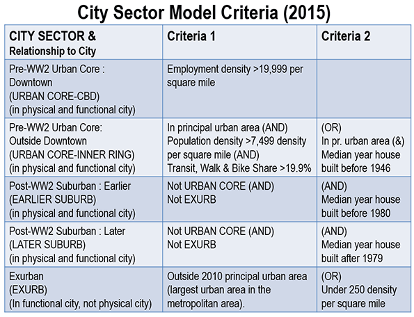
    This article classifies 2010 to 2014 core city population growth by the percentage of urban core population according to the 2010 census. The classification was developed using my City Sector Model, which classifies every zip code in metropolitan areas as pre-War urban core (CBD and inner ring) or post-War suburban or exurban (Figure 1). Simplified, the City Sector Model classifies as urban core any small area with an employment density of 20,000 per square mile or more or a population density of 7,500 per square mile or more, with a transit, cycling and walking work trip market share of 20% or more (Note).

    Growth by Extent of Urban Core Population

    More than 50% of the growth between 2010 and 2014 has been in core municipalities that are more than 90% post World War II suburban or exurban (0 to 10% urban core). This growth share is nearly one-half higher than their population share of 35%.

    These findings are based on the City Sector Model (Figure 1 and Note), which classifies small areas (zip code tabulation areas) principally using population density and commuting market share data that attempts to replicate urban areas as they functioned before World War II.

    These most suburban of core cities grew the fastest, up 6.8% from 2010 to 2014. These municipalities had less than 10% of their population in urban core neighborhods, and include core cities that annexed substantial suburban or rural territory, such as Phoenix, San Jose, Charlotte, Tampa, Orlando and San Antonio. Those that were most heavily urban core in form grew 4,0 percent, which was slightly behind the national average of 4.7 percent. The core cities had less than 10% of their population living in urban core neighborhoods, and include New York, Buffalo, Providence, San Francisco and Boston (Figure 2)  

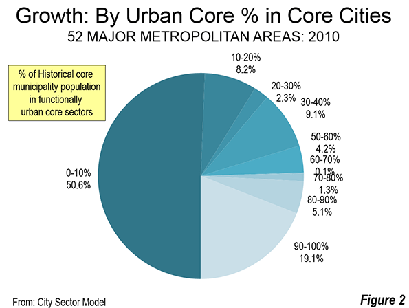
    The functionally suburban and exurban areas accounted for approximately 58% of the population in the core cities. This leaves approximately 42% of the population living in areas that are similar to the urban areas as they functioned in 1940.

    Approximately 70% of the growth was in the 33 historical core municipalities that are more than 60% suburban or exurban.

    At the same time, the five core cities with the largest urban core percentages accounted for nearly 20% of the growth, compared to their 22 percent of the population. Approximately 80% of this growth was in New York, which is estimated to have added the largest population (316,000) among the core cities.

    Ten Fastest Growing Core Municipalities

    Six of the ten fastest growing core cities had urban core shares of less than 10%, including Austin, Orlando, Charlotte, Raleigh, Atlanta and San Antonio. A seventh, Denver was less than 15% urban by function. Two more had more than 50% in urban core population, Washington and Seattle (Table). Eight of the 10 fastest growing core cities were in the South, including Washington.

    Table
    Population Growth: 2010-2014
    Core Municipalities in Major Metropolitan Areas
    Population Population in Pre-War Functional Urban Core
    Rank Historical Core Municipality Metropolitan Area 2010 2014 % Change Historical Core Municipality Metropolitan Area
    1 Austin Austin, TX     790,637      912,791 15.5% 4.8% 2.2%
    2 New Orleans New Orleans. LA     343,829      384,320 11.8% 37.9% 10.9%
    3 Denver Denver, CO     600,024      663,862 10.6% 13.1% 3.1%
    4 Orlando Orlando, FL     238,304      262,372 10.1% 0.0% 0.0%
    5 Charlotte Charlotte, NC-SC     735,780      809,958 10.1% 0.0% 0.0%
    6 Seattle Seattle, WA     608,660      668,342 9.8% 52.6% 10.5%
    7 Washington Washington, DC-VA-MD-WV     601,723      658,893 9.5% 83.7% 16.5%
    8 Raleigh Raleigh, NC     403,947      439,896 8.9% 0.0% 0.0%
    9 Atlanta Atlanta, GA     420,279      456,002 8.5% 9.2% 0.7%
    10 San Antonio San Antonio, TX  1,327,605   1,436,697 8.2% 0.1% 0.1%
    11 Miami Miami, FL     399,508      430,332 7.7% 23.0% 3.0%
    12 Oklahoma City Oklahoma City, OK     580,003      620,602 7.0% 6.1% 2.8%
    13 Dallas Dallas-Fort Worth, TX  1,197,833   1,281,047 6.9% 1.1% 0.5%
    14 Tampa Tampa-St. Petersburg, FL     335,709      358,699 6.8% 0.0% 0.0%
    15 Houston Houston, TX  2,097,217   2,239,558 6.8% 1.4% 0.5%
    16 Nashville Nashville, TN     603,527      644,014 6.7% 0.7% 0.2%
    17 Richmond Richmond, VA     204,237      217,853 6.7% 26.0% 4.5%
    18 San Jose San Jose, CA     952,562   1,015,785 6.6% 0.1% 0.2%
    19 Minneapolis Minneapolis-St. Paul, MN-WI     382,578      407,207 6.4% 86.0% 0.0%
    20 Boston Boston, MA-NH     617,594      655,884 6.2% 90.4% 35.5%
    21 Phoenix Phoenix, AZ  1,447,552   1,537,058 6.2% 0.0% 0.0%
    22 San Diego San Diego, CA  1,301,621   1,381,069 6.1% 2.8% 1.2%
    23 Portland Portland, OR-WA     583,778      619,360 6.1% 37.9% 10.0%
    24 Columbus Columbus, OH     788,577      835,957 6.0% 12.0% 5.0%
    25 Oakland San Francisco-Oakland, CA     390,719      413,775 5.9% 54.7% 0.0%
    26 San Francisco San Francisco-Oakland, CA     805,235      852,469 5.9% 94.4% 0.0%
    27 Las Vegas Las Vegas, NV     583,787      613,599 5.1% 7.8% 2.8%
    28 Stl Paul Minneapolis-St. Paul, MN-WI     285,068      297,640 4.4% 38.7% 0.0%
    29 Sacramento Sacramento, CA     466,488      485,199 4.0% 7.6% 1.6%
    30 New York New York, NY-NJ-PA  8,175,136   8,491,079 3.9% 97.3% 52.8%
    31 Jacksonville Jacksonville, FL     821,784      853,382 3.8% 0.0% 0.0%
    32 Los Angeles Los Angeles, CA  3,792,627   3,928,864 3.6% 30.1% 10.6%
    33 Indianapolis Indianapolis. IN     820,442      848,788 3.5% 11.0% 4.8%
    34 Grand Rapids Grand Rapids, MI     188,040      193,792 3.1% 19.1% 3.8%
    35 Louisville Louisville, KY-IN     597,336      612,780 2.6% 17.8% 8.7%
    36 San Bernardino Riverside-San Bernardino, CA     209,952      215,213 2.5% 0.0% 0.0%
    37 Kansas City Kansas City, MO-KS     459,787      470,800 2.4% 19.8% 5.4%
    38 Salt Lake City Salt Lake City, UT     186,443      190,884 2.4% 21.4% 3.7%
    39 Philadelphia Philadelphia, PA-NJ-DE-MD  1,526,006   1,560,297 2.2% 86.1% 25.8%
    40 Memphis Memphis, TN-MS-AR     646,889      656,861 1.5% 3.7% 1.8%
    41 Norfolk Virginia Beach-Norfolk, VA-NC     242,803      245,428 1.1% 2.8% 0.4%
    42 Chicago Chicago, IL-IN-WI  2,695,598   2,722,389 1.0% 76.6% 25.8%
    43 Milwaukee Milwaukee,WI     594,740      599,642 0.8% 55.4% 23.6%
    44 Providence Providence, RI-MA     178,036      179,154 0.6% 92.6% 26.2%
    45 Cincinnati Cincinnati, OH-KY-IN     296,950      298,165 0.4% 54.2% 10.1%
    46 Baltimore Baltimore, MD     620,961      622,793 0.3% 67.7% 16.2%
    47 Birmingham Birmingham, AL     212,288      212,247 0.0% 0.0% 0.0%
    48 Hartford Hartford, CT     124,775      124,705 -0.1% 88.5% 11.3%
    49 Pittsburgh Pittsburgh, PA     305,702      305,412 -0.1% 78.0% 15.9%
    50 Rochester Rochester, NY     210,512      209,983 -0.3% 51.7% 11.4%
    51 St. Louis St. Louis,, MO-IL     319,294      317,419 -0.6% 84.1% 11.7%
    52 Buffalo Buffalo, NY     261,310      258,703 -1.0% 96.0% 29.2%
    53 Cleveland Cleveland, OH     396,814      389,521 -1.8% 80.1% 22.2%
    54 Detroit Detroit,  MI     713,777      680,250 -4.7% 32.1% 6.5%
    Data from:
    US Census Bureau
    City Sector Model (2015)


    Austin has been the fastest growing historical core municipality over the four years. In 2010, Austin had 790,000 residents, and has increased 15.5% to 913,000.

    New Orleans was the second fastest growing, adding 11.8%, continuing its recovery from the huge population loss after Hurricanes Katrina and the related flood control failures, which the Independent Levee Investigation Team concluded was the "single most costly catastrophic failure of an engineered system in history." New Orleans has now recovered more than 70% of its population loss between 2005 and 2006. In 2005, the population was 455,000, which fell to 209,000 in 2006, before recovering to the 2014 figure of 384,000.

    The balance of the top five, Denver, Orlando and Charlotte also grew more than 10% between 2010 and 2014. The second five in population growth were Seattle, Washington (DC), Raleigh, Atlanta and San Antonio.

    Slowest Growing Core Municipalities

    Eight of the 10 slowest growing municipalities were in the Northeast and Midwest, including Detroit, Cleveland, Buffalo, St. Louis, Rochester, Pittsburgh, Hartford and Cincinnati. Two were in the South, Birmingham and Baltimore.

    Eight core municipalities lost population. The largest loss was in Detroit, which fell 4.7% to 680,000. This is a continuation of the catastrophic losses from 1950, when Detroit had 1,850,000 residents. It may be surprising, however, that Detroit has become the core municipality with the greatest loss only this year. Until 2013, St. Louis had lost the largest share of its population from 1950 (when its population was 857,000). By 2014, Detroit had lost 63.2% of its 1950 population, compared to the 63.0% loss in St. Louis). St. Louis also continued its losses, dropping 0.6% between 2010 and 2014.

    Cleveland and Buffalo had greater losses than St. Louis. Cleveland slipped 1.8% to 390,000, while Buffalo dropped 1.0% to 259,000. Losses of less than 0.5% were posted in Pittsburgh, Hartford and Birmingham.

    More-than-a-Million Municipalities

    The United States added its 10th municipality with more than 1,000,000 in the 2014 estimates. San Jose joins Los Angeles and San Diego as California’s third more-than-a-million city. As a result, California now equals Texas, which had led the nation, with three cities with more than 1,000,000 residents in previous years (Houston, San Antonio and Dallas).

    Texas, however, should soon reclaim the exclusive title. The city of Austin forecasts that its population will reach 1,000,000 population early in the 2020s, which would give Texas four more-than-a-million municipalities. This forecast, however, could be too conservative. If the Texas city continues to grow at its current rate, a population of more than 1,000,000 could be reached before the 2020 census.

    Yet, the core municipalities with more than 1,000,000 – particularly the new entrants – are not particularly dense, but are virtually suburban in form, that is, auto-oriented and generally low density.  Three have less than one percent of their population in urban core neighborhoods, including Phoenix, San Antonio and San Jose, Dallas and Houston have less than two percent of their population in urban core neighborhoods, while San Diego has less than three percent. Even in Los Angeles only 30% of residents live in urban core neighborhoods. Only three of the largest municipalities have most of their population in urban core neighborhoods, New York, (97%), Philadelphia (86%) and Chicago (77%).  

    Lower Density Growth Could be Dominant in Core Cities

    The new population estimates provide little indication how much core city growth since 2010 is urban intensification versus low density suburban development. However, the concentration of growth where urban cores are smaller implies that growth has been stronger at lower in the suburban portions of core municipalities. To know for sure will require waiting for later small area data.

    Related article: U.S. Population Estimate Accuracy: 2010

    Note: The analysis is based on the City Sector Model (Figure 1), which classifies small areas (ZIP codes, more formally, ZIP Code Tabulation Areas, or ZCTAs) in major metropolitan areas based upon their behavioral functions as urban cores, suburbs or exurbs. The criteria used are generally employment and population densities and modes of work trip travel. The purpose of the urban core sectors is to replicate, to the best extent possible, the urban form as it existed before World War II, when urban densities were much higher and when a far larger percentage of urban travel was on transit or by walking. The suburban and exurban sectors replicate automobile oriented suburbanization that began in the 1920s and escalated strongly following World War II.

    Wendell Cox is principal of Demographia, an international public policy and demographics firm. He is co-author of the "Demographia International Housing Affordability Survey" and author of "Demographia World Urban Areas" and "War on the Dream: How Anti-Sprawl Policy Threatens the Quality of Life." He was appointed to three terms on the Los Angeles County Transportation Commission, where he served with the leading city and county leadership as the only non-elected member. He served as a visiting professor at the Conservatoire National des Arts et Metiers, a national university in Paris. Wendell Cox is Chair, Housing Affordability and Municipal Policy for the Frontier Centre for Public Policy (Canada), is a Senior Fellow of the Center for Opportunity Urbanism and is a member of the Board of Advisors of the Center for Demographics and Policy at Chapman University.

    Photo: Newest more-than-a-million US core city, virtually all-suburban San Jose by Robert Campbell [GFDL or CC BY-SA 3.0], via Wikimedia Commons

  • Malls Washed Up? Not Quite Yet

    Maybe it’s that reporters don’t like malls. After all they tend to be young, highly urban, single, and highly educated, not the key demographic at your local Macy’s, much less H&M.

    But for years now, the conventional wisdom in the media is that the mall—particularly in the suburbs—is doomed. Here a typical sample from The Guardian: “Once-proud visions of suburban utopia are left to rot as online shopping and the resurgence of city centers make malls increasingly irrelevant to young people.”

    To be sure, there are hundreds of outmoded malls, long-in-the-tooth complexes most commonly found in working-class suburbs and inner-ring city neighborhoods. Some will never come back. By some estimates, something close to 10 to 15 percent of the country’s estimated 1,000 malls will go out of business over the next decade; many of them are located in areas where budgets have been very tight, with locals tending to shop at “power centers” built around low-end discounters such as Target or Walmart.

    But the notion that Americans don’t like malls anymore is misleading. The roughly 400 malls that service more-affluent communities—like those typically anchored by a Bloomingdale’s or Nordstrom—recovered most quickly from the recession, and now appear to be doing quite well.

    To suggest malls are dead based on failure in failed places would be like suggesting that the manifest shortcomings of Baltimore or Buffalo means urban centers are not doing well. Like cities, not all malls are alike.

    Looking across the entire landscape, it’s clear the mall is transforming itself to meet the needs of a changing society but is hardly in its death throes. Last year, vacancy rates in malls flattened for the first time since the recession. The gains from e-commerce—6.5 percent of sales last year, up from 3.5 percent in 2010—has had an effect, but bricks and mortar still constitutes upwards of 90 percent of sales. There’s still little new construction, roughly one-seventh what it was in 2006, but that’s roughly twice that in 2010.

    Shopping in stores, according to a recent study from A.T. Kearney, is preferred over online-only by every age group, including, most surprisingly, millennials, although many of them research on the web, then visit the store, and sometimes then order on line. The malls that are flourishing tend to be newer or retrofitted and are pitched at expanding demographic markets. These “cathedrals of commerce” in the past tended to reflect the mass sameness of mid-century America; those in the future focus on distinct niches—ethnic, income, even geographical—that are not only viable but highly profitable.

    This leaves us with a tale of two kinds of malls. One clear dividing line is customer base. In the ’80s and before, malls succeeded fairly universally, notes Houston investor Blake Tartt. But now it’s a matter of being in the right place. “Everything has changed and you have to be with the right demographics,” he suggests. “It’s not so much about the mall but the location that matters.”

    Old malls in declining areas, notes a recent analysis by the consultancy Costar, do truly face a “bleak future” and should look to be converted into apartments, houses, corporate headquarters, or churches.

    In contrast, affluent urban areas are becoming an unexpected hotspot for malls—even outlet malls are opening open in the urban core. You now see gigantic malls in places like Manhattan: the Shops on Columbus mall in Manhattan, the world’s fifth-most profitable mall, looks inside like it was teleported from Orange County, California, or, god forbid, Long Island.

    This is not unusual across the world. Malls are on the march in many of the world’s biggest cities, including Istanbul, Mumbai, Singapore, and Dubai. Today Asia is the site of seven of the world’s 10 largest malls, in places like Beijing, Dubai, and Kuala Lumpur.

    In the developing world, malls grow as local shopping streets either gentrify or decay. This is particularly true in fast-growing developing countries where malls are often seen as an escape from hot, humid, dirty and even dangerous urban environments. Indian novelist and Mumbai blogger Amit Varma suggests that these folks like malls “because they are relatively clean and sanitized” as opposed to the city’s pollution-choked, beggar-ridden and often foul-smelling streets.

    Ethnic Malls

    Within the U.S., demographic change is creating opportunities for a new breed of mall-maker. Across the country, savvy investors and developers have been buying older malls, which tended to serve either Anglo or African-American customers, and shifting them instead to focus on fast-growing ethnic markets. Such malls can now be found in traditional Latino areas such as Southern California and Texas, but they also exist in Atlanta, Las Vegas, Oklahoma City, and Charlotte, places that have recently become major hubs for immigrants.

    “We had a terrific recession,” notes Los Angeles-based mall maven Jose Legaspi, who has developed 12 such malls around the country. “You do well if you target specific niches that are growing. You can’t make it with a plain vanilla mall. We are creating in these places a Hispanic downtown.”

    Fort Worth’s 1.2 million-square-foot La Gran Plaza, which Legaspi manages, epitomizes the advantages of such marketing. When investor Andrew Segal bought the mall in 2005, it was a failing facility that primarily serviced a working-class Anglo population. Barely 15 percent of the mall’s tenants were both open and paying rent.

    Segal quickly recognized that the area around the mall—like much of urban Texas—was becoming more diverse, in this case largely Latino.

    Segal and Legaspi redid the once prototypical plain vanilla mall to look more like a Northern Mexican town plaza, a design pattern developed by Los Angeles architect David Hidalgo. Latino customers are drawn to amenities like large and comfortable family bathrooms, an anchor supermarket, mariachi music shows, and even Catholic masses. There is also a “swap meet” that accommodates small vendors, something that Legaspi sees as essential to creating “a carnival of retail experiences.” By 2008, when the face-lift was complete, the mall achieved 90 percent occupancy. Today La Gran Plaza is effectively “full,” says Segal, who is considering a further expansion of the mall.

    The viability of ethnic malls in hard times demonstrated their viability in better ones. When Dr. Alethea Hsu opened her Diamond Jamboree Center in Irvine, California, the state was reeling from the recession. Yet from the time she opened in 2008, her mall, which focuses on Orange County’s large and expanding Asian population, has been fully occupied. It includes various realty offices, hair salons, medical offices, a Korean supermarket, and a small Japanese department store, all primarily aimed at a diverse set of Asian customers. The biggest problem—for those interested in choosing among various kinds of Chinese, Vietnamese, Korean, or Japanese cuisine—is not that it’s deserted but that it’s often difficult to get a parking space.

    Be sure of this: The ethnic mall is no flash in the pan, at least as long as immigrants pour into this country. By 2000, one in five American children already were the progeny of immigrants, mostly Asian or Latino; today they make up as much as one-third of American kids. These kids, and their own offspring, not to mention Anglo or African-American friends, have been brought up with food and fashion tastes that often originate in Mexico, Taiwan, Japan, Korea, or China. When I was a kid growing up in New York, you went to Chinatown or Little Italy for an ethnic infusion. Now you get in your car, park, and get options not so dissimilar than what you would find—usually in a mall—in Mexico City, Mumbai, or Singapore.

    The World According to Rick

    For most of America, says Los Angeles developer Rick Caruso, the future lies in replicating the function that Main Street once served. Rather than simply a center for instant consumption and transactions, the mall is a social meeting point, says Caruso, who has 10 developments under his belt. To make it all work means adding often unconventional amenities such as live entertainment or the lighting of Christmas trees and the Chanukah menorah.

    This is part of a broader mall trend in which developers see their properities as community and entertainment centers, an approach adopted now by mainstream mall developers such as Westfield, whose projects are increasingly open-air and built around amenities such as health clubs and trendy restaurants and cafes.

    The ultimate example may be the Caruso-owned Grove, a giant open-air mall that lies next to the Farmers’ Market, one of the oldest and beloved shopping areas in Los Angeles. The world’s eighth-most profitable mall, the Grove is laid out like a Disneyesque Main Street and is particularly appealing to families and tourists. Overall, the Grove now ranks among L.A.’s leading tourist attractions. This reflects both the development’s pleasant, pedestrian-oriented design as well as proximity to the Farmer’s Market, which remains, as has been traditional, largely a collection of small, idiosyncratic stalls.

    A sense of place is what makes the Grove—and, to a lesser extent, Caruso’s other developments—work. Located in the Miracle Mile district of L.A., it attracts a huge urban population that includes old Jewish shoppers from the immediate area as well as the growing ranks of hipsters, tourists, and the rest of the vast diversity that is Los Angeles. Caruso’s other centers, like the Commons in suburban Calabasas and The Promenade in Westlake, may lack global appeal but they succeed as anchors of their communities. Without developed, large historic downtowns, these communities still need a central place, and for them, the malls, however imperfectly, come closest to delivering it.

    In today’s environment, Caruso suggests, a mall has to offer something that online retailers, power centers, or catalogs cannot provide: a social experience. “You have to differentiate yours, offer a place for people to gather for holidays. People are yearning for a place to connect with each other. We are not building just town centers, but the centers of towns.”

    Ironically these malls are fulfilling a role that some urbanists have denounced the suburbs for lacking. “What do most urbanists want?,” asks David Levinson, director of the Networks, Economics, and Urban Systems Research Group. “A lively, pedestrian realm, clean, free of automobiles, with a variety of activities, the ability to interact with others and randomly encounter friends and acquaintances. This is what the shopping mall gives.”

    The New Town Center: With Suburban Revival, New Hope for Malls

    The notion of dead malls has been connected to a similar idea about the inevitable demise of the suburbs, which appeared possible at the height of the recession, but has since been shown to be largely false. Suburbs may not be booming as in the ’90s, but they are now growing as fast as core cities, and constitute more than 70 percent of all new population and 80 percent of new job growth since 2010.

    Surprisingly, the most recent numbers suggest that the outer suburbs and exurbs, once consigned to Hades by the new urbanist crowd, have begun to roar back. Millennials, as they get older, notes Jed Kolko, now seem to be moving to what he calls “the suburbiest” areas farther out on the periphery. 

    It is in these areas that malls may have their greatest future. In communities like Irvine, where the Spectrum development has become the de facto downtown, or Sugar Land, a highly diverse outer suburb of Houston, the “town center” is essentially a mall in brick, made to look like an old Main Street but filled with chain stores and specialty restaurants. Many residents of fast-growing communities like Sugar Land, which has 83,000 residents, are relative newcomers, and for them such town centers are the focus of their communities.

    It is time to dispense with the twin memes of mall- and suburb-bashing, and begin appreciating and improving how most Americans live and shop. The malls of the future indeed may be very different in many ways—more segmented by income and ethnicity, more entertainment- and experience-oriented. But they will continue to serve an important focus for most American communities. And at a time when many of our most celebrated cities have themselves become giant malls (is there any place on Earth more boring than the area around Times Square?), the future of malls may prove brighter, and even more transformative, than commonly imagined.

    This piece first appeared at The Daily Beast.

    Joel Kotkin is executive editor of NewGeography.com and Roger Hobbs Distinguished Fellow in Urban Studies at Chapman University, and a member of the editorial board of the Orange County Register. He is also executive director of the Houston-based Center for Opportunity Urbanism. His newest book, The New Class Conflict is now available at Amazon and Telos Press. He is also author of The City: A Global History and The Next Hundred Million: America in 2050.  He lives in Los Angeles, CA.

    Photo: “Thegrove“. Licensed under CC BY-SA 3.0 via Wikipedia.

  • Volcano Urbanism

    Before I get to the urbanism portion of this post I need to do a quick geography and geology lesson for those readers who are unfamiliar with Hawaii. The state is made up of a chain of islands: Oahu, Maui, Kauai, Molokai, Lanai, the Big Island (that’s the largest island called “Hawaii”) and numerous lesser islands. All the islands formed from the same volcanic hot spot on the sea floor over a period of 70 million years.

    Screen Shot 2015-05-25 at 1.13.56 AM
    Google

    Screen Shot 2015-05-23 at 7.12.16 PM

    DSC_6314 Picture 082 DSC_7911 Lava (2)

    lava_6687

    The hot spot continually pushes up molten lava from the center of the Earth forming new islands. Over time the plates of the Earth’s crust drift carrying the old islands away while a new island forms at the hot spot. The old islands gradually erode, shrink, and disappear under the sea, while a new underwater mountain gradually pushes its way up to the surface. At the moment the youngest island is the Big Island and it’s still growing in size. These Hawaiian volcanoes aren’t the kind that lay dormant for centuries and then suddenly erupt like Mount Saint Helens, Vesuvius, or Pinatubo. Instead they are shield volcanoes that continually release slow steady flows of lava. You can actually walk away from the lava as it inches forward.

    Screen Shot 2015-05-24 at 12.34.25 AM Screen Shot 2015-05-22 at 8.33.00 PM Screen Shot 2015-05-24 at 12.37.36 AM

    Screen Shot 2015-05-24 at 12.37.57 AM

    I just took these photos of the newest lava field that formed from June through February this year.

    Screen Shot 2015-05-22 at 8.31.12 PM

    Screen Shot 2015-05-22 at 8.29.18 PM

    Screen Shot 2015-05-22 at 8.32.18 PM


    Screen Shot 2015-05-23 at 10.47.32 AM

    Screen Shot 2015-05-23 at 10.47.18 AM

    Screen Shot 2015-05-23 at 10.22.52 AM

    Screen Shot 2015-05-25 at 2.26.54 AM

    Screen Shot 2015-05-25 at 2.06.39 AM

    Screen Shot 2015-05-25 at 2.19.09 AM

    In the first hundred years after a new lava flow pioneer species slowly colonize the rocks. First there’s moss and ferns. Then the rugged ohia trees sprout. Then coconut palms wash up on the newly formed black sand beach and take root. After two hundred years a dense forest is established.

    Screen Shot 2015-05-25 at 3.42.25 AM

    Screen Shot 2015-05-25 at 4.56.42 AM

    Screen Shot 2015-05-25 at 4.01.41 AM

    Screen Shot 2015-05-25 at 4.52.54 AM

    Screen Shot 2015-05-25 at 4.52.20 AM

    Screen Shot 2015-05-25 at 4.55.26 AM

    Screen Shot 2015-05-25 at 4.26.57 AM

    Screen Shot 2015-05-25 at 12.45.32 PM

    Soon after the lava cools a new kind of pioneer species arrives to colonize the rocks. Before the lava flow the land had already been carved up into farms and subdivisions which were covered over. Once the lava cooled the old lots were resurveyed and sold off at bargain prices. Lots began at $1,000. When I asked one resident about the precarious nature of the location he explained, “You pay your dollar and you take your chances.” Then he asked me where I live. San Francisco. “Hmmm. Nothing dangerous about living on top of a massive earthquake fault is there?” We continued to talk. Seattle and Portland have volcanoes in their back yards too. Manhattan has seen terrorist attacks and super storms in recent years. Florida and Louisiana are directly in harm’s way when it comes to hurricanes. Entire towns in Kansas get swept away in tornadoes. There are 180 aging nuclear power plants all over the mainland. What could possibly go wrong there? Or you could live in New Jersey which has… New Jersey. His point was that people were more directly engaged with the danger on the lava flow. They live with the risk everyday and can’t let themselves forget what they’re dealing with. The lava could return tomorrow or it might be another 50 years. No one knows. Everyone enjoys life, but has a Plan B.

    Screen Shot 2015-05-25 at 4.50.51 AM

    Screen Shot 2015-05-25 at 4.11.37 AM

    Screen Shot 2015-05-25 at 4.49.24 AM

    Screen Shot 2015-05-25 at 4.25.39 AM

    Screen Shot 2015-05-25 at 4.07.43 AM

    Screen Shot 2015-05-25 at 3.43.38 AM

    As I took these photos of the lava dwellers I was fascinated. It wasn’t so much the dramatic location or funky architecture, although they’re certainly worth exploring on those terms. Instead, I looked at these lava homes as a window into the past. Historically this is exactly how all towns and cities began including Rome, New York, London, and Toronto. There’s no city water supply. No complex sewer system was installed ahead of development. There are no paved roads. No banks have financed any of these buildings. No insurance company provided coverage. There are no building codes, zoning regulations, or government inspections. (Or more accurately, all those strictures exist, but they’re simply unenforced.)

    Screen Shot 2015-05-25 at 1.45.25 PMGoogle

    Screen Shot 2015-05-25 at 12.40.12 PM

    Screen Shot 2015-05-25 at 4.06.18 AM

    Screen Shot 2015-05-25 at 4.24.19 AM

    Screen Shot 2015-05-25 at 4.02.46 AM

    The average North American town gets 37 inches of rain per year. This part of Hawaii gets 148. That’s over 12 feet of water falling from the sky. The simplest way to supply an off-grid home with water in this location is to collect it from the roof and hold it in a tank. The water is generally clean enough to be used directly for things like washing, but the drinking water needs to be filtered or boiled. The climate is mild year round so there’s never a need for heating or cooling, particularly if a home is built with traditional techniques that provide shade and cross ventilation. A barbecue size tank of propane will keep a stove going for a very long time. A few solar panels and/or a small marine style wind turbine will keep the lights on, especially if they’re compact florescent or LED. Ten years ago people would have used gasoline generators, but these days solar is more cost effective, silent, safer, and more convenient. Toilets come in the same form that was used by Moses, Napoleon, and Abraham Lincoln. Dry composting toilets use no water and the waste quickly turns to soil so long as sawdust or other carbon rich material is added to neutralize the nitrogen.

    Screen Shot 2015-05-25 at 12.41.01 PM

    Screen Shot 2015-05-25 at 12.43.00 PM

    Screen Shot 2015-05-25 at 4.04.40 AM

    Screen Shot 2015-05-25 at 4.27.56 AM

    A D9 bulldozer and driver can be rented for the day to do the work of a thousand men in a single afternoon. The rough lava is scraped flat enough to be passable by car. A few loads of cinder help smooth the way. The roads are only improved where and as needed in an incremental fashion. The value of individual vacant lots rises as ease of access improves so homes tend to be built in clusters along the cinder roads. This level of infrastructure is in keeping with the needs and budget of the community without involving higher levels of government.

    Screen Shot 2015-05-25 at 4.01.11 AM

    I’m not advocating building in this kind of environment and I’m not romanticizing counter culture off-grid communities. What I am saying is that in a country that prides itself on freedom and private property rights you shouldn’t have to move to the side of a volcano to escape the regulations and social constraints that make self built mortgage free homes illegal everywhere else. I know the arguments against this sort of thing. Shanty towns are dangerous and unhealthy. They will be populated by meth labs and crack whores. These people aren’t paying their fair share of taxes to society. This isn’t a wholesome environment for children, the elderly, or the disabled. This sort of thing will destroy nearby property values. The list goes on. My response is pretty straightforward. So… we don’t have unhealthy pockets of poverty, meth labs, and crack whores in places that were built entirely to code and heavily regulated?

    I will say that in this kind of community there’s no need for “affordable housing”. Even the most cash strapped residents can provide shelter for themselves. It may not be the sort of home most middle class people aspire to, but living here is entirely voluntary within a community of like-minded self-selecting people. As time passes each of these makeshift structures is being improving and upgraded. The shanties are gradually evolving into more substantial and respectable homes in the same way the moss and ferns yield to ohia and palm trees. This is an extreme example, but the same principles can be applied selectively in other locations in a more intentional fashion. These lava homes provide a glimpse into what town building used to look like and could look like again if the banks, regulators, and Upright Citizens Brigade cut people a bit more slack. I’m not counting on that, but it’s good to see obscure demonstrations of the historical pattern playing out in forgotten corners to remind us of how things were done before the days of the production home builder, the master planned community, and the seventeen volume building code.

    John Sanphillippo lives in San Francisco and blogs about urbanism, adaptation, and resilience at granolashotgun.com. He’s a member of the Congress for New Urbanism, films videos for faircompanies.com, and is a regular contributor to Strongtowns.org. He earns his living by buying, renovating, and renting undervalued properties in places that have good long term prospects. He is a graduate of Rutgers University.

  • The Best Cities For Jobs 2015

    Since the U.S. economy imploded in 2008, there’s been a steady shift in leadership in job growth among our major metropolitan areas. In the earliest years, the cities that did the best were those on the East Coast that hosted the two prime beneficiaries of Washington’s resuscitation efforts, the financial industry and the federal bureaucracy. Then the baton was passed to metro areas riding the boom in the energy sector, which, if not totally dead in its tracks, is clearly weaker.

    Right now, job creation momentum is the strongest in tech-oriented metropolises and Sun Belt cities with lower costs, particularly the still robust economies of Texas.

    Topping our annual ranking of the best big cities for jobs are the main metro areas of Silicon Valley: the San Francisco-Redwood City-South San Francisco Metropolitan Division, followed by San Jose-Sunnyvale-Santa Clara, swapping their positions from last year.

    Our rankings are based on short-, medium- and long-term job creation, going back to 2003, and factor in momentum — whether growth is slowing or accelerating. We have compiled separate rankings for America’s 70 largest metropolitan statistical areas (those with nonfarm employment over 450,000), which are our focus this week, as well as medium-size metro areas (between 150,000 and 450,000 nonfarm jobs) and small ones (less than 150,000 nonfarm jobs) in order to make the comparisons more relevant to each category. (For a detailed description of our methodology, click here.)

    An Economy Fit For Geeks

    Venture capital and private-equity firms keep pouring money into U.S. technology companies, lured by the promise of huge IPO returns. Last year was the best for new stock offerings since the peak of the dot-com bubble, with 71 biotech IPOs and 55 tech IPOs. It’s continuing to fuel strong job creation in Silicon Valley. Employment expanded 4.8% in the San Francisco Metropolitan Division in 2014, which includes the job-rich suburban expanses of San Mateo to the south, and employment is up 21.2% since 2009. This has been paced by growth in professional business services jobs in the area, up 9% last year, and in information jobs, which includes many social media functions – information employment expanded 8.3% last year and is up 28.7% since 2011.

    San Jose which, like San Francisco, was devastated in the tech crash a decade ago, has also rebounded smartly. The San Jose MSA clocked 4.9% job growth last year and 20.0% since 2009. Employment in manufacturing, once the heart of the local economy, has grown 8% since 2011, after a decade of sharp reversals, but the number of information jobs there has exploded, up 16% last year and 35.7% since 2011.

    Meanwhile, there’s been a striking reversal of fortune in the greater Washington, D.C., area, while the greater New York area has also fallen off the pace. In the years after the crash, soaring federal spending pushed Washington-Arlington-Alexandria to as high as fifth on our annual list of the best cities for jobs; this year it’s a meager 47th, with job growth of 1.5% in 2014, following meager 0.2% growth in 2013, while Northern Virginia (50th) and Silver Spring-Frederick-Rockville (64th) also lost ground, dropping, respectively, five and 15 places.

    Job growth has also slowed in the greater New York region, which also was an early star performer in the immediate aftermath of the recession, in part due to the bank bailout that consolidated financial institutions in their strongest home region. Virtually all the areas that make up greater New York have lost ground in our ranking: the New York City MSA has fallen to 17th place from seventh last year, as employment growth tailed off to 2.6% in 2014 from 3.2% in 2013. Meanwhile Nassau-Suffolk ranks 49th, Rockland-Westchester 60th and Newark is second from the bottom among the biggest metro areas in 69th place.

    The Shift To ‘Opportunity Cities’ Continues

    Not every tech hot spot has the Bay Area’s advantages, which include venture capital, the presence of the world’s top technology companies and a host of people with the know-how to start and grow companies.

    But other metro areas have something Silicon Valley lacks: affordable housing. Most of the rest of our top 15 metro areas have far lower home prices than the Bay Area, or for that matter Boston, Los Angeles or New York. And they also have experienced strong job growth, often across a wider array of industries, which provides opportunities for a broader portion of the population.

    The combination of lower prices and strong job opportunities are what earns them our label of “opportunity cities.” The Bay Area may attract many of the best and brightest, but it is too expensive for most. Despite the current boom, the area’s population growth has been quite modest — San Jose has had an average population growth rate of 1.5% over the past four years. In contrast, seven of our top 10 metro areas, including third place Dallas-Plano-Irving, Texas, and No. 4 Austin, Texas, are also in the top 10 in terms of population growth since 2000. If prices and costs are reasonable, people will go to places where work is most abundant.

    In the Dallas metro area, the job count grew 4.2% last year, paced by an 18.6% expansion in professional business services, while overall employment is up 15.7% since 2009. Job growth last year in Austin, Texas, was a healthy 3.9%, while the information sector expanded by 4.7% and since 2011 by 17.8%.

    Many Texas cities, of course, have benefited from the energy boom — the recent downturn in oil prices make it likely that growth, particularly in No. 6 Houston, will decelerate in coming years.

    But what is most remarkable about the top-performing cities is the diversity of their economies. Most have tech clusters, but several, such as Houston, Nashville, Tenn., Dallas and Charlotte, N.C., have growing manufacturing, trade, transportation and business services sectors. The immediate prognosis, however, may be brightest in places like Denver and Orlando, where growth is less tied to energy than business services, trade and tourism. Nashville, which places fifth on our list, has particularly bright prospects, due not only to its growing tech and manufacturing economy, but also its strong health care sector which, according to one recent study, contributes an overall economic benefit of nearly $30 billion annually and more than 210,000 jobs to the local economy.

    The Also-Rans

    Some economies lower in our rankings have made strong improvements, notably Atlanta-Sandy Spring-Roswell, which rose to 12th this year, a jump of 12 places. Long a star performer, the Georgia metro area stumbled through the housing bust, but it appears to have regained its footing, with strong job growth across a host of fields from manufacturing and information to health, and particularly business services, a category in which employment has increased 24% since 2009.

    In California, one big turnaround story has been the Riverside-San Bernardino area, which gained six places to rank 11th this year as it has again begun to benefit from migration caused by coastal Southern California’s impossibly high home prices.

    Several mid-American metro areas also are showing strong improvement. Louisville-Jefferson County, Ky., jumped fifteen places to 21st, propelled by strong growth in manufacturing, business services and finance. Kansas City, Kan. (23rd), and Kansas City, Mo. (46th), both made double-digit jumps in our rankings. In Michigan, Detroit-Dearborn-Livonia, bolstered by the recovery of the auto industry, gained six places to 59th, while manufacturing hub Warren-Troy-Farmington Hills picked up two to 39th. These may not be high growth areas, but these metro area no longer consistently sit at the bottom of the list.

    Losing Ground

    One of the biggest resurgent stars in past rankings, New Orleans-Metairie, dropped 17 places to 43rd, while Oklahoma City fell 17 places to 33rd. These cities lack the economic diversity to withstand a long-term loss of energy jobs if the sector goes into a prolonged downturn.

    Yet perhaps the most troubling among the also-rans are the metro areas that have remained steadily at the bottom. These are largely Rust Belt cities such as last place Camden, N.J., which has been at or near that position for years.

    Future Prospects

    Now the best prospects appear to be in tech-heavy regions, but it’s important to recognize that a key contributor to the tech sector’s frenzy of venture capital and IPOs had been the Federal Reserve’s unprecedented monetary interventions, which are now phasing out. As it is, headwinds to expansion in the Bay Area are strong. High housing prices, according to recent study, may make it very difficult for these companies to expand their local workforces. The median price of houses in tech suburbs like Los Gatos now stand at nearly $2 million — rich for all but a few — while downtown Palo Alto office rents have risen an impossible 43% in the last five years.

    Companies like Google, which has run into opposition over its proposed new headquarters expansion, may choose to shift more employment to other tech centers, such as Austin, Denver, Seattle, Raleigh and Salt Lake City, where the cost of doing business tends to be less. Similarly the stronger dollar could erode the modest progress made by some industrial cities, such as Detroit and Warren, as it gives a strong advantage to foreign competitors.

    Normally we would expect these processes to play out slowly. But in these turbulent times, it’s best to keep an eye out for disruptive changes — a new economic cataclysm, should one occur, could quickly shift the playing field once again.

    Joel Kotkin is executive editor of NewGeography.com and Roger Hobbs Distinguished Fellow in Urban Studies at Chapman University, and a member of the editorial board of the Orange County Register. He is also executive director of the Houston-based Center for Opportunity Urbanism. His newest book, The New Class Conflict is now available at Amazon and Telos Press. He is also author of The City: A Global History and The Next Hundred Million: America in 2050.  He lives in Los Angeles, CA.

    Michael Shires, Ph.D. is a professor at Pepperdine University School of Public Policy.

  • Best Cities for Jobs 2015

    best cities for jobs main page

  • 2015 How We Pick the Best Cities for Job Growth

    The methodology for our 2015 ranking, which seeks to measure the robustness of metro areas’ growth both recently and over time, largely corresponds to that used in previous years, with a minor addition to mitigate the volatility that the Great Recession has introduced into the time series. It allows the rankings to include all of the metropolitan statistical areas (MSAs) for which the Bureau of Labor Statistics reports monthly employment data. They are derived from three-month rolling averages of U.S. Bureau of Labor Statistics “state and area” unadjusted employment data reported from November 2003 to January 2015.

    The data reflect the North American Industry Classification System categories, including total nonfarm employment, manufacturing, financial services, business and professional services, educational and health services, information, retail and wholesale trade, transportation and utilities, leisure and hospitality, and government.

    We used five measures of growth to rank MSAs over the past 10 years. “Large” areas include those with a current nonfarm employment base of at least 450,000 jobs. “Midsize” areas range from 150,000 to 450,000 jobs. “Small” areas have as many as 150,000 jobs. This year’s rankings reflect the new Office of Management and Budget definitions of MSAs for all series released after March 2015. As a result, the MSA listed in this year’s rankings do not necessary correspond directly to those listed in prior years. In some instances, MSAs were consolidated with others — for example Pascagoula, MS, was combined with the Gulfport-Biloxi, MS, MSA to form the new Gulfport-Biloxi-Pascagoula, MS, MSA. Others were separated from previously consolidated MSAs and in still other instances individual counties were shifted from one MSA to another. The bottom line is that this year’s rankings are based on good time series for the newly defined MSAs but may not be precisely comparable to those listed in prior years. The total number of MSAs included in this year’s rankings has risen from 398 to 421. This year’s rankings reflect the current size of each MSA’s employment.

    The index is calculated from a normalized, weighted summary of: 1) recent growth trend: the current and prior year’s employment growth rates, with the current year emphasized (two points); 2) mid-term growth: the average annual 2009-2014 growth rate (two points); 3) long-term momentum: the sum of the 2009-2014and 2003-2008 employment growth rates multiplied by the ratio of the 2003-2008 growth rate over the 2009-2014 growth rate (one point); 4) current year growth (one point); and 5) the average of each year’s growth rate, normalized annually, for the last 10 years (two points). This methodology corresponds exactly to that used in last year’s rankings. The goal of our methodology is to capture a snapshot of the present and prospective employment outlook in each MSA, and these revisions allow the reader to have a better sense of the employment climate in each.

  • All Cities Rankings – 2015 Best Cities for Job Growth

    Read about how we selected the 2015 Best Cities for Job Growth

    We used five measures of growth to rank MSAs over the past 10 years. “Large” areas include those with a current nonfarm employment base of at least 450,000 jobs. “Midsize” areas range from 150,000 to 450,000 jobs. “Small” areas have as many as 150,000 jobs. This year’s rankings reflect the new Office of Management and Budget definitions of MSAs for all series released after March 2015. As a result, the MSA listed in this year’s rankings do not necessary correspond directly to those listed in prior years. In some instances, MSAs were consolidated with others — for example Pascagoula, MS, was combined with the Gulfport-Biloxi, MS, MSA to form the new Gulfport-Biloxi-Pascagoula, MS, MSA. Others were separated from previously consolidated MSAs and in still other instances individual counties were shifted from one MSA to another. The bottom line is that this year’s rankings are based on good time series for the newly defined MSAs but may not be precisely comparable to those listed in prior years. The total number of MSAs included in this year’s rankings has risen from 398 to 421. This year’s rankings reflect the current size of each MSA’s employment.

    2015 Overall Ranking Area 2015 Size 2015 Weighted INDEX  2014 Nonfarm Emplymt (1000s)  Overall Rank Change 2014 Overall Rank 
    1 Midland, TX S 100.0          98.6 9 10
    2 Greeley, CO S 99.8        101.5 7 9
    3 Odessa, TX S 99.7          81.7 20 23
    4 San Francisco-Redwood City-South San Francisco, CA Metro Div. L 97.5     1,034.2 -1 3
    5 San Jose-Sunnyvale-Santa Clara, CA L 97.2     1,031.5 -3 2
    6 Provo-Orem, UT M 97.1        219.7 1 7
    7 Naples-Immokalee-Marco Island, FL S 96.3        136.2 8 15
    8 Cape Coral-Fort Myers, FL M 96.0        239.1 17 25
    9 Columbus, IN S 93.0          51.8 29 38
    10 Dallas-Plano-Irving, TX Metro Div. L 91.4     2,346.3 25 35
    11 Fargo, ND-MN S 91.2        140.2 21 32
    12 Austin-Round Rock, TX L 90.9        924.9 0 12
    13 Nashville-Davidson–Murfreesboro–Franklin, TN L 90.8        892.0 11 24
    14 Auburn-Opelika, AL S 90.7          60.7 -3 11
    15 Napa, CA S 90.7          69.5 14 29
    16 Gainesville, GA S 90.5          82.0 64 80
    17 Ames, IA S 90.4          53.6 34 51
    18 Houston-The Woodlands-Sugar Land, TX L 90.2     2,973.6 -1 17
    19 Denver-Aurora-Lakewood, CO L 89.6     1,364.0 17 36
    20 Fayetteville-Springdale-Rogers, AR-MO M 89.1        227.8 33 53
    21 Orlando-Kissimmee-Sanford, FL L 88.8     1,135.7 10 31
    22 Merced, CA S 87.9          64.5 59 81
    23 Bend-Redmond, OR S 87.7          70.3 49 72
    24 Victoria, TX S 87.3          45.5 10 34
    25 Lake Charles, LA S 86.7        101.1 119 144
    26 Charlotte-Concord-Gastonia, NC-SC L 86.2     1,085.8 22 48
    27 The Villages, FL S 85.9          26.1  
    28 Jonesboro, AR S 85.9          54.6 -6 22
    29 Elkhart-Goshen, IN S 85.0        124.5 -25 4
    30 San Antonio-New Braunfels, TX L 84.9        960.3 10 40
    31 St. George, UT S 84.8          54.6 -23 8
    32 North Port-Sarasota-Bradenton, FL M 84.2        276.7 64 96
    33 Riverside-San Bernardino-Ontario, CA L 83.9     1,319.1 23 56
    34 Savannah, GA M 83.8        168.1 29 63
    35 Bismarck, ND S 83.8          74.0 -34 1
    36 Atlanta-Sandy Springs-Roswell, GA L 83.2     2,551.7 65 101
    37 Fort Worth-Arlington, TX Metro Div. L 82.8        993.0 0 37
    38 Seattle-Bellevue-Everett, WA Metro Div. L 82.6     1,575.6 12 50
    39 Bakersfield, CA M 82.6        261.7 2 41
    40 Ogden-Clearfield, UT M 82.6        234.7 67 107
    41 Raleigh, NC L 82.5        571.5 -28 13
    42 Charleston-North Charleston, SC M 81.8        324.3 44 86
    43 Coeur d’Alene, ID S 81.7          58.3 17 60
    44 Miami-Miami Beach-Kendall, FL Metro Div. L 81.5     1,114.8 15 59
    45 New York City, NY L 80.9     4,165.9 -15 30
    46 West Palm Beach-Boca Raton-Delray Beach, FL Metro Div. L 80.8        576.2 57 103
    47 Fort Collins, CO S 79.9        148.9 -19 28
    48 Myrtle Beach-Conway-North Myrtle Beach, SC-NC S 79.5        148.3 13 61
    49 San Luis Obispo-Paso Robles-Arroyo Grande, CA S 79.5        111.1 38 87
    50 Salt Lake City, UT L 78.7        666.2 -7 43
    51 Fort Lauderdale-Pompano Beach-Deerfield Beach, FL Metro Div. L 78.2        796.1 57 108
    52 Winchester, VA-WV S 78.0          60.7 14 66
    53 Tuscaloosa, AL S 77.7        104.4 118 171
    54 Louisville-Jefferson County, KY-IN L 77.4        642.4 101 155
    55 Portland-Vancouver-Hillsboro, OR-WA L 77.0     1,090.5 15 70
    56 Longview, WA S 77.0          39.4 168 224
    57 Greenville-Anderson-Mauldin, SC M 77.0        394.4 16 73
    58 Port St. Lucie, FL S 76.6        135.3 51 109
    59 Hilton Head Island-Bluffton-Beaufort, SC S 76.5          72.0  
    60 San Angelo, TX S 76.4          49.3 -41 19
    61 Fresno, CA M 76.1        319.2 16 77
    62 Corpus Christi, TX M 75.8        196.6 17 79
    63 Bowling Green, KY S 75.5          72.6 -11 52
    64 Laredo, TX S 74.9        100.2 -20 44
    65 San Rafael, CA Metro Div. S 74.9        113.0  
    66 Daphne-Fairhope-Foley, AL S 74.8          66.8  
    67 Bellingham, WA S 74.1          88.4 35 102
    68 Clarksville, TN-KY S 74.0          88.2 71 139
    69 Kansas City, KS L 74.0        458.8 100 169
    70 Longview, TX S 74.0        105.4 62 132
    71 Grand Rapids-Wyoming, MI L 73.9        521.2 -57 14
    72 Santa Rosa, CA M 73.7        193.7 49 121
    73 McAllen-Edinburg-Mission, TX M 73.5        247.9 -24 49
    74 Boulder, CO M 73.3        178.3 -68 6
    75 Boise City, ID M 73.0        284.2 -30 45
    76 Wenatchee, WA S 72.6          41.1 35 111
    77 Olympia-Tumwater, WA S 72.4        108.9 18 95
    78 Columbus, OH L 72.3     1,028.2 -4 74
    79 Lafayette-West Lafayette, IN S 72.3        102.3 66 145
    80 Anaheim-Santa Ana-Irvine, CA Metro Div. L 72.3     1,524.2 68 148
    81 Phoenix-Mesa-Scottsdale, AZ L 71.4     1,900.0 3 84
    82 Modesto, CA M 71.4        163.0 40 122
    83 Santa Maria-Santa Barbara, CA M 71.1        180.0 97 180
    84 San Diego-Carlsbad, CA L 71.1     1,372.3 43 127
    85 Grants Pass, OR S 71.0          24.5  
    86 Asheville, NC M 70.8        181.4 8 94
    87 El Centro, CA S 70.8          54.9 -69 18
    88 Oakland-Hayward-Berkeley, CA Metro Div. L 70.5     1,081.5 38 126
    89 Charlottesville, VA S 69.8        112.2 73 162
    90 Manchester, NH NECTA S 69.8        108.6 139 229
    91 Farmington, NM S 69.7          53.5 231 322
    92 Lexington-Fayette, KY M 69.6        268.3 119 211
    93 Las Vegas-Henderson-Paradise, NV L 69.1        896.8 35 128
    94 Kahului-Wailuku-Lahaina, HI S 69.0          72.4  
    95 Santa Cruz-Watsonville, CA S 68.9          95.7 25 120
    96 Stockton-Lodi, CA M 68.8        212.1 62 158
    97 Indianapolis-Carmel-Anderson, IN L 68.7     1,006.9 22 119
    98 Tampa-St. Petersburg-Clearwater, FL L 68.5     1,224.2 20 118
    99 Salinas, CA S 68.4        132.8 140 239
    100 Prescott, AZ S 68.1          60.9 83 183
    101 Logan, UT-ID S 67.8          58.3 -36 65
    102 Oklahoma City, OK L 67.8        625.8 -47 55
    103 Medford, OR S 67.5          82.0 112 215
    104 Mount Vernon-Anacortes, WA S 67.4          48.1 8 112
    105 Lynn-Saugus-Marblehead, MA NECTA Div. S 67.3          45.2  
    106 Baton Rouge, LA M 66.9        399.8 -42 64
    107 Brockton-Bridgewater-Easton, MA NECTA Div. S 66.8          80.8 -31 76
    108 Spartanburg, SC S 66.8        140.6 -87 21
    109 Wilmington, NC S 66.4        117.1 -42 67
    110 Jacksonville, FL L 65.9        633.5 -35 75
    111 New Bedford, MA NECTA S 65.8          66.3 -20 91
    112 Tacoma-Lakewood, WA Metro Div. M 65.8        293.5 101 213
    113 Athens-Clarke County, GA S 65.3          93.3 48 161
    114 Chico, CA S 65.1          76.9 -31 83
    115 Iowa City, IA S 65.0          99.0 -76 39
    116 Pensacola-Ferry Pass-Brent, FL M 64.7        166.6 114 230
    117 Los Angeles-Long Beach-Glendale, CA Metro Div. L 64.4     4,295.6 40 157
    118 Lawrence-Methuen Town-Salem, MA-NH NECTA Div. S 63.8          79.2  
    119 Visalia-Porterville, CA S 63.5        116.6 -22 97
    120 Sebastian-Vero Beach, FL S 63.4          48.4 153 273
    121 Tyler, TX S 63.2        100.2 -15 106
    122 Danbury, CT NECTA S 63.2          79.5 86 208
    123 Des Moines-West Des Moines, IA M 63.1        345.7 -81 42
    124 Cheyenne, WY S 62.4          47.1 -56 68
    125 Casper, WY S 62.4          43.2 -1 124
    126 Sebring, FL S 62.4          25.8  
    127 Dubuque, IA S 62.3          60.3 24 151
    128 Ocala, FL S 62.2          98.3 167 295
    129 Cleveland, TN S 62.2          46.0 -82 47
    130 Janesville-Beloit, WI S 61.6          66.8 33 163
    131 Haverhill-Newburyport-Amesbury Town, MA-NH NECTA Div. S 61.3          62.8 -85 46
    132 Burlington-South Burlington, VT NECTA S 61.0        124.2 65 197
    133 Kennewick-Richland, WA S 60.7        104.6 -18 115
    134 Lubbock, TX S 60.6        138.6 -108 26
    135 College Station-Bryan, TX S 60.5        106.1 -119 16
    136 Vallejo-Fairfield, CA S 60.5        130.4 2 138
    137 Elizabethtown-Fort Knox, KY S 60.4          54.5 48 185
    138 Madison, WI M 60.3        386.9 5 143
    139 Beaumont-Port Arthur, TX M 60.2        168.8 232 371
    140 Yuba City, CA S 59.8          40.5 55 195
    141 St. Cloud, MN S 59.6        107.0 -41 100
    142 Houma-Thibodaux, LA S 59.4        101.6 -109 33
    143 Durham-Chapel Hill, NC M 59.3        294.2 -51 92
    144 Sioux Falls, SD S 59.2        146.5 -82 62
    145 Corvallis, OR S 59.2          40.3 83 228
    146 Sacramento–Roseville–Arden-Arcade, CA L 59.0        902.1 46 192
    147 Brownsville-Harlingen, TX S 58.9        138.1 -93 54
    148 Gettysburg, PA S 58.7          34.9  
    149 Pueblo, CO S 57.9          60.6 -19 130
    150 Columbia, MO S 57.9          98.5 -145 5
    151 Boston-Cambridge-Newton, MA NECTA Div. L 57.8     1,742.0 -52 99
    152 Burlington, NC S 57.5          60.9 187 339
    153 Minneapolis-St. Paul-Bloomington, MN-WI L 57.4     1,903.7 15 168
    154 Blacksburg-Christiansburg-Radford, VA S 57.3          77.0 -38 116
    155 Killeen-Temple, TX S 57.2        136.2 -84 71
    156 Fond du Lac, WI S 57.1          48.3 18 174
    157 Idaho Falls, ID S 56.8          60.2 -44 113
    158 Madera, CA S 56.7          36.5 -4 154
    159 Warren-Troy-Farmington Hills, MI Metro Div. L 56.4     1,182.7 16 175
    160 Knoxville, TN M 56.2        382.8 60 220
    161 Chambersburg-Waynesboro, PA S 55.9          59.8  
    162 Springfield, MO M 55.9        204.8 -84 78
    163 Crestview-Fort Walton Beach-Destin, FL S 55.4        103.4 19 182
    164 Salem, OR M 55.3        151.5 14 178
    165 Redding, CA S 54.9          63.1 11 176
    166 Grand Forks, ND-MN S 54.8          58.0 -26 140
    167 Macon, GA S 54.7        102.7 149 316
    168 Mankato-North Mankato, MN S 54.7          56.4 -70 98
    169 Panama City, FL S 54.4          78.4 20 189
    170 Midland, MI S 54.3          37.7  
    171 Williamsport, PA S 54.0          56.8 17 188
    172 Punta Gorda, FL S 53.8          44.6 -87 85
    173 Worcester, MA-CT NECTA M 53.7        277.1 102 275
    174 Kokomo, IN S 53.6          40.7 -84 90
    175 Augusta-Richmond County, GA-SC M 53.4        228.2 126 301
    176 Reno, NV M 53.4        204.2 -10 166
    177 Ocean City, NJ S 53.3          36.6 -95 82
    178 Spokane-Spokane Valley, WA M 53.3        235.4 58 236
    179 Dover-Durham, NH-ME NECTA S 53.2          52.7  
    180 Tulsa, OK M 53.1        445.6 -16 164
    181 Grand Junction, CO S 53.1          61.9 28 209
    182 Lincoln, NE M 52.8        185.7 -78 104
    183 Monroe, MI S 52.6          41.8 -60 123
    184 Lowell-Billerica-Chelmsford, MA-NH NECTA Div. S 52.3        147.6 62 246
    185 Colorado Springs, CO M 52.3        263.9 -1 184
    186 Hattiesburg, MS S 52.0          62.5 40 226
    187 Flagstaff, AZ S 51.9          64.3 -52 135
    188 Reading, PA M 51.7        176.7 99 287
    189 Columbia, SC M 51.2        375.8 -8 181
    190 Peabody-Salem-Beverly, MA NECTA Div. S 51.2          96.2 31 221
    191 Morgantown, WV S 51.0          70.2 -103 88
    192 Rapid City, SD S 50.9          65.0 35 227
    193 Deltona-Daytona Beach-Ormond Beach, FL M 50.8        184.6 24 217
    194 Richmond, VA L 50.7        638.1 -17 177
    195 Jacksonville, NC S 50.5          50.0 -54 141
    196 Barnstable Town, MA NECTA S 50.3          97.6 -79 117
    197 Cincinnati, OH-KY-IN L 49.8     1,047.8 22 219
    198 Ithaca, NY S 49.7          70.6 -69 129
    199 Jackson, TN S 49.7          65.6 0 199
    200 Gainesville, FL S 49.4        135.2 50 250
    201 Lewiston, ID-WA S 49.0          27.4 56 257
    202 Appleton, WI S 48.9        122.1 56 258
    203 Green Bay, WI M 48.4        173.6 28 231
    204 Lancaster, PA M 48.4        240.5 77 281
    205 Pocatello, ID S 48.2          35.2 71 276
    206 Dover, DE S 47.5          68.0 -69 137
    207 Sherman-Denison, TX S 47.5          45.6 -74 133
    208 Omaha-Council Bluffs, NE-IA L 47.3        486.6 -35 173
    209 Framingham, MA NECTA Div. M 47.3        171.0 -57 152
    210 Battle Creek, MI S 47.2          58.9 -76 134
    211 Hammond, LA S 47.2          44.7  
    212 Hanford-Corcoran, CA S 47.1          37.6 58 270
    213 Sioux City, IA-NE-SD S 47.0          88.2 -57 156
    214 Trenton, NJ M 46.9        252.9 -100 114
    215 Manhattan, KS S 46.7          43.7 68 283
    216 New Orleans-Metairie, LA L 46.7        566.2 -111 105
    217 Chicago-Naperville-Arlington Heights, IL Metro Div. L 46.7     3,597.7 8 225
    218 Eau Claire, WI S 46.5          85.3 -48 170
    219 Wilmington, DE-MD-NJ Metro Div. M 46.5        352.1 -9 210
    220 Billings, MT S 46.1          83.1 -78 142
    221 Tallahassee, FL M 46.1        176.3 77 298
    222 Yakima, WA S 46.0          80.5 -20 202
    223 Oxnard-Thousand Oaks-Ventura, CA M 46.0        295.6 10 233
    224 Sheboygan, WI S 45.3          60.9 54 278
    225 Lafayette, LA M 45.3        221.8 -198 27
    226 Greenville, NC S 45.1          78.4 -137 89
    227 Urban Honolulu, HI L 44.9        467.2 -102 125
    228 Dalton, GA S 44.8          67.7 163 391
    229 Delaware County, PA M 44.7        232.4  
    230 Lakeland-Winter Haven, FL M 44.6        205.5 5 235
    231 Portsmouth, NH-ME NECTA S 44.1          83.6 -162 69
    232 Wausau, WI S 44.0          71.6 104 336
    233 El Paso, TX M 43.8        296.7 -87 146
    234 Abilene, TX S 43.7          69.2 -47 187
    235 Allentown-Bethlehem-Easton, PA-NJ M 43.7        354.0 20 255
    236 Evansville, IN-KY M 43.4        157.9 60 296
    237 Eugene, OR S 43.1        149.7 -15 222
    238 Jackson, MS M 42.9        273.3 71 309
    239 Kansas City, MO L 42.7        571.7 89 328
    240 Albany, OR S 42.7          41.1  
    241 Springfield, MA-CT NECTA M 42.7        324.0 70 311
    242 Bremerton-Silverdale, WA S 41.9          87.1 72 314
    243 Owensboro, KY S 41.7          52.6 -78 165
    244 Kankakee, IL S 41.6          45.2 -2 242
    245 Huntsville, AL M 41.6        217.9 -42 203
    246 Washington-Arlington-Alexandria, DC-VA-MD-WV Metro Div. L 41.5     2,560.7 -87 159
    247 Valdosta, GA S 41.3          55.5 37 284
    248 Philadelphia City, PA L 41.0        684.3 18 266
    249 Muskegon, MI S 40.9          63.0 4 253
    250 Gadsden, AL S 40.8          37.6 4 254
    251 Hagerstown-Martinsburg, MD-WV S 40.7        103.4 -60 191
    252 Chattanooga, TN-GA M 40.4        242.1 36 288
    253 Sumter, SC S 40.4          38.9 -81 172
    254 New Haven, CT NECTA M 39.9        282.4 -47 207
    255 Nassau County-Suffolk County, NY Metro Div. L 39.9     1,292.3 -61 194
    256 Harrisonburg, VA S 39.4          65.4 -50 206
    257 Grand Island, NE S 38.9          43.0  
    258 Lawrence, KS S 38.8          52.9 -46 212
    259 Florence, SC S 38.4          85.6 -63 196
    260 Walla Walla, WA S 38.4          27.1  
    261 Lewiston-Auburn, ME NECTA S 38.2          50.6 4 265
    262 Northern Virginia, VA L 38.1     1,388.0 -113 149
    263 Middlesex-Monmouth-Ocean, NJ L 38.1        845.9  
    264 Bridgeport-Stamford-Norwalk, CT NECTA M 38.0        409.4 -13 251
    265 Elgin, IL Metro Div. M 37.9        249.9  
    266 Amarillo, TX S 37.9        117.4 -52 214
    267 Rome, GA S 37.6          40.4 62 329
    268 Lake County-Kenosha County, IL-WI Metro Div. M 37.6        399.2 -108 160
    269 Flint, MI S 37.4        142.3 79 348
    270 Leominster-Gardner, MA NECTA S 37.3          50.4 50 320
    271 Springfield, OH S 37.2          52.3 -135 136
    272 Rockford, IL M 37.1        150.9 88 360
    273 Anchorage, AK M 37.1        177.7 -87 186
    274 Greensboro-High Point, NC M 37.0        354.7 31 305
    275 Fort Wayne, IN M 36.7        212.9 -77 198
    276 Scranton–Wilkes-Barre–Hazleton, PA M 36.7        262.5 89 365
    277 Ann Arbor, MI M 36.6        211.3 -124 153
    278 Missoula, MT S 36.3          57.6 -168 110
    279 Winston-Salem, NC M 36.0        255.2 -38 241
    280 Hot Springs, AR S 35.8          38.0 14 294
    281 Bloomsburg-Berwick, PA S 35.7          43.2  
    282 Hartford-West Hartford-East Hartford, CT NECTA L 35.7        571.3 -26 256
    283 Albany-Schenectady-Troy, NY L 35.7        457.2 20 303
    284 Morristown, TN S 35.5          44.2 -13 271
    285 Lebanon, PA S 35.4          51.4 -138 147
    286 Brunswick, GA S 35.1          41.7 91 377
    287 Rochester, MN S 34.2        114.9 -97 190
    288 Waco, TX S 33.9        112.4 -50 238
    289 Canton-Massillon, OH M 33.9        172.2 -55 234
    290 Hinesville, GA S 33.6          19.9 -47 243
    291 St. Joseph, MO-KS S 33.2          62.9 -124 167
    292 Milwaukee-Waukesha-West Allis, WI L 33.1        845.7 -3 289
    293 Oshkosh-Neenah, WI S 32.9          95.1 -88 205
    294 Waterloo-Cedar Falls, IA S 32.4          92.7 -57 237
    295 Kingsport-Bristol-Bristol, TN-VA S 32.3        122.2 35 330
    296 Birmingham-Hoover, AL L 32.2        516.4 -32 264
    297 Providence-Warwick, RI-MA NECTA L 32.1        568.7 0 297
    298 Gary, IN Metro Div. M 32.1        276.5 8 306
    299 Florence-Muscle Shoals, AL S 31.9          56.4 -59 240
    300 Jackson, MI S 31.9          55.9 41 341
    301 Harrisburg-Carlisle, PA M 31.9        330.1 -78 223
    302 Palm Bay-Melbourne-Titusville, FL M 31.7        199.8 67 369
    303 La Crosse-Onalaska, WI-MN S 31.6          77.2 -172 131
    304 Montgomery County-Bucks County-Chester County, PA Metro Div. L 31.5     1,024.8  
    305 State College, PA S 31.4          77.3 -89 216
    306 Joplin, MO S 31.2          81.6 -127 179
    307 Columbus, GA-AL S 31.2        123.2 -55 252
    308 New Bern, NC S 31.0          44.1  
    309 Roanoke, VA M 30.9        161.4 -1 308
    310 Duluth, MN-WI S 30.9        134.0 -110 200
    311 Pittsburgh, PA L 30.7     1,164.6 -29 282
    312 South Bend-Mishawaka, IN-MI S 30.4        137.6 38 350
    313 Detroit-Dearborn-Livonia, MI Metro Div. L 30.2        734.4 54 367
    314 California-Lexington Park, MD S 30.1          44.3  
    315 Alexandria, LA S 30.1          64.3 32 347
    316 Akron, OH M 30.1        332.2 -72 244
    317 Las Cruces, NM S 30.1          71.1 -124 193
    318 Kalamazoo-Portage, MI S 29.9        141.0 58 376
    319 Orange-Rockland-Westchester, NY L 29.9        688.8  
    320 Saginaw, MI S 29.6          88.7 -53 267
    321 Memphis, TN-MS-AR L 29.5        622.5 19 340
    322 Little Rock-North Little Rock-Conway, AR M 29.3        347.8 -62 260
    323 Portland-South Portland, ME NECTA M 29.2        193.8 -49 274
    324 Waterbury, CT NECTA S 29.0          68.4 -62 262
    325 Erie, PA S 29.0        130.6 0 325
    326 Taunton-Middleborough-Norton, MA NECTA Div. S 28.5          58.7  
    327 Topeka, KS S 28.3        111.6 -36 291
    328 Lansing-East Lansing, MI M 28.3        225.6 -127 201
    329 Johnson City, TN S 28.2          78.6 34 363
    330 Calvert-Charles-Prince George’s, MD M 28.2        387.7 -67 263
    331 Buffalo-Cheektowaga-Niagara Falls, NY L 27.9        556.7 -32 299
    332 Lake Havasu City-Kingman, AZ S 27.8          46.6 17 349
    333 Rochester, NY L 27.4        527.8 -26 307
    334 York-Hanover, PA M 27.2        180.1 -2 332
    335 Baltimore City, MD M 27.2        365.1 -18 317
    336 Bloomington, IN S 27.1          77.0 -77 259
    337 Silver Spring-Frederick-Rockville, MD Metro Div. L 26.9        576.2 -76 261
    338 Salisbury, MD-DE S 25.7        142.3 0 338
    339 Kingston, NY S 25.7          60.9 -20 319
    340 Cedar Rapids, IA S 25.2        140.5 -60 280
    341 Pittsfield, MA NECTA S 25.1          41.4 1 342
    342 Wheeling, WV-OH S 25.0          69.1 -138 204
    343 Warner Robins, GA S 24.9          70.5 -71 272
    344 Niles-Benton Harbor, MI S 24.7          60.2 -40 304
    345 Dayton, OH M 24.6        374.5 33 378
    346 Tucson, AZ M 24.5        370.8 -46 300
    347 Wichita, KS M 24.4        294.5 -45 302
    348 St. Louis, MO-IL L 24.1     1,314.3 -27 321
    349 Cleveland-Elyria, OH L 24.0     1,038.2 -15 334
    350 Montgomery, AL M 23.9        170.3 -58 292
    351 Toledo, OH M 23.8        298.3 -72 279
    352 Albuquerque, NM M 23.3        380.3 14 366
    353 Bangor, ME NECTA S 23.3          66.4 -85 268
    354 Nashua, NH-MA NECTA Div. S 22.8        125.4 -64 290
    355 Virginia Beach-Norfolk-Newport News, VA-NC L 22.7        753.9 -43 312
    356 Fort Smith, AR-OK S 22.6        113.4 -2 354
    357 Champaign-Urbana, IL S 22.6        108.7 -13 344
    358 Hickory-Lenoir-Morganton, NC S 22.6        147.2 -12 346
    359 Bergen-Hudson-Passaic, NJ L 22.5        895.1 -73 286
    360 Mansfield, OH S 22.4          52.9 23 383
    361 Santa Fe, NM S 21.8          61.8 -43 318
    362 Newark, NJ-PA Metro Div. L 21.7     1,188.1 -35 327
    363 Danville, IL S 21.6          29.3 33 396
    364 Glens Falls, NY S 21.5          53.6 -2 362
    365 Cape Girardeau, MO-IL S 21.4          44.7 -72 293
    366 Altoona, PA S 21.1          61.1 -29 337
    367 Parkersburg-Vienna, WV S 21.1          43.2 7 374
    368 Springfield, IL S 20.8        111.4 -37 331
    369 Racine, WI S 20.6          76.0 -13 356
    370 Bay City, MI S 20.6          37.4 -57 313
    371 Great Falls, MT S 20.4          35.5 -221 150
    372 Watertown-Fort Drum, NY S 20.4          41.6  
    373 Peoria, IL M 20.1        178.0 -18 355
    374 Yuma, AZ S 20.0          52.7 -59 315
    375 Lynchburg, VA S 19.8        103.7 -7 368
    376 Fayetteville, NC S 19.8        128.6 -99 277
    377 Cumberland, MD-WV S 19.5          39.9 -67 310
    378 Davenport-Moline-Rock Island, IA-IL M 19.3        183.0 -27 351
    379 Mobile, AL M 19.3        174.8 -15 364
    380 Staunton-Waynesboro, VA S 18.4          48.6  
    381 Monroe, LA S 18.3          78.3 -136 245
    382 Lawton, OK S 18.0          45.4 -134 248
    383 Syracuse, NY M 17.8        318.1 -40 343
    384 Youngstown-Warren-Boardman, OH-PA M 17.8        226.2 -39 345
    385 Fairbanks, AK S 17.7          37.5 -153 232
    386 Huntington-Ashland, WV-KY-OH S 17.0        141.5 -29 357
    387 Elmira, NY S 16.4          39.6 -2 385
    388 Muncie, IN S 16.3          51.0 -65 323
    389 Beckley, WV S 16.1          47.3  
    390 Dothan, AL S 16.1          57.3 -17 373
    391 Dutchess County-Putnam County, NY Metro Div. S 15.6        142.4  
    392 Carson City, NV S 15.6          27.9 1 393
    393 Camden, NJ Metro Div. L 15.5        515.3 -14 379
    394 Gulfport-Biloxi-Pascagoula, MS M 15.5        152.0 -147 247
    395 Lima, OH S 15.3          52.6 -71 324
    396 Albany, GA S 15.2          61.6 -37 359
    397 Shreveport-Bossier City, LA M 15.1        183.5 -44 353
    398 Homosassa Springs, FL S 14.9          32.5  
    399 Goldsboro, NC S 14.4          42.6 -114 285
    400 Texarkana, TX-AR S 13.9          59.1 -28 372
    401 Wichita Falls, TX S 13.7          58.5 -15 386
    402 Decatur, AL S 13.0          53.8 -50 352
    403 Jefferson City, MO S 12.0          76.1 -42 361
    404 Utica-Rome, NY S 11.9        127.8 -34 370
    405 Terre Haute, IN S 11.7          70.8 -47 358
    406 Bloomington, IL S 11.2          94.4 -22 384
    407 Charleston, WV S 10.5        123.3 -20 387
    408 Johnstown, PA S 10.0          57.8 -27 381
    409 Carbondale-Marion, IL S 9.8          54.4  
    410 Decatur, IL S 9.7          50.8 -20 390
    411 Sierra Vista-Douglas, AZ S 9.4          34.7  
    412 Michigan City-La Porte, IN S 9.4          41.9 -15 397
    413 East Stroudsburg, PA S 9.4          55.4  
    414 Norwich-New London-Westerly, CT-RI NECTA S 9.2        127.5 -25 389
    415 Binghamton, NY S 8.8        105.7 -21 394
    416 Anniston-Oxford-Jacksonville, AL S 8.6          46.3 -28 388
    417 Weirton-Steubenville, WV-OH S 6.9          42.9 -37 380
    418 Rocky Mount, NC S 6.3          57.7 -26 392
    419 Pine Bluff, AR S 3.7          33.9 -21 398
    420 Atlantic City-Hammonton, NJ S 3.6        130.6 -25 395
    421 Vineland-Bridgeton, NJ S 3.6          56.6 -39 382
  • Large Cities Rankings – 2015 Best Cities for Job Growth

    Read about how we selected the 2015 Best Cities for Job Growth

    We used five measures of growth to rank MSAs over the past 10 years. “Large” areas include those with a current nonfarm employment base of at least 450,000 jobs. “Midsize” areas range from 150,000 to 450,000 jobs. “Small” areas have as many as 150,000 jobs. This year’s rankings reflect the new Office of Management and Budget definitions of MSAs for all series released after March 2015. As a result, the MSA listed in this year’s rankings do not necessary correspond directly to those listed in prior years. In some instances, MSAs were consolidated with others — for example Pascagoula, MS, was combined with the Gulfport-Biloxi, MS, MSA to form the new Gulfport-Biloxi-Pascagoula, MS, MSA. Others were separated from previously consolidated MSAs and in still other instances individual counties were shifted from one MSA to another. The bottom line is that this year’s rankings are based on good time series for the newly defined MSAs but may not be precisely comparable to those listed in prior years. The total number of MSAs included in this year’s rankings has risen from 398 to 421. This year’s rankings reflect the current size of each MSA’s employment.

    2015  Rank Among Small Cities Area 2015 Weighted INDEX  2014 Nonfarm Emplymt (1000s)  Rank Change 2014 Size Ranking
    1 San Francisco-Redwood City-South San Francisco, CA Metro Div. 97.5    1,034.2 1 2
    2 San Jose-Sunnyvale-Santa Clara, CA 97.2    1,031.5 -1 1
    3 Dallas-Plano-Irving, TX Metro Div. 91.4    2,346.3 6 9
    4 Austin-Round Rock, TX 90.9       924.9 -1 3
    5 Nashville-Davidson–Murfreesboro–Franklin, TN 90.8       892.0 1 6
    6 Houston-The Woodlands-Sugar Land, TX 90.2    2,973.6 -1 5
    7 Denver-Aurora-Lakewood, CO 89.6    1,364.0 3 10
    8 Orlando-Kissimmee-Sanford, FL 88.8    1,135.7 0 8
    9 Charlotte-Concord-Gastonia, NC-SC 86.2    1,085.8 5 14
    10 San Antonio-New Braunfels, TX 84.9       960.3 2 12
    11 Riverside-San Bernardino-Ontario, CA 83.9    1,319.1 6 17
    12 Atlanta-Sandy Springs-Roswell, GA 83.2    2,551.7 12 24
    13 Fort Worth-Arlington, TX Metro Div. 82.8       993.0 -2 11
    14 Seattle-Bellevue-Everett, WA Metro Div. 82.6    1,575.6 1 15
    15 Raleigh, NC 82.5       571.5 -11 4
    16 Miami-Miami Beach-Kendall, FL Metro Div. 81.5    1,114.8 2 18
    17 New York City, NY 80.9    4,165.9 -10 7
    18 West Palm Beach-Boca Raton-Delray Beach, FL Metro Div. 80.8       576.2 7 25
    19 Salt Lake City, UT 78.7       666.2 -6 13
    20 Fort Lauderdale-Pompano Beach-Deerfield Beach, FL Metro Div. 78.2       796.1 7 27
    21 Louisville-Jefferson County, KY-IN 77.4       642.4 15 36
    22 Portland-Vancouver-Hillsboro, OR-WA 77.0    1,090.5 -3 19
    23 Kansas City, KS 74.0       458.8 16 39
    24 Grand Rapids-Wyoming, MI 73.9       521.2 -21 3
    25 Columbus, OH 72.3    1,028.2 -5 20
    26 Anaheim-Santa Ana-Irvine, CA Metro Div. 72.3    1,524.2 8 34
    27 Phoenix-Mesa-Scottsdale, AZ 71.4    1,900.0 -5 22
    28 San Diego-Carlsbad, CA 71.1    1,372.3 4 32
    29 Oakland-Hayward-Berkeley, CA Metro Div. 70.5    1,081.5 2 31
    30 Las Vegas-Henderson-Paradise, NV 69.1       896.8 3 33
    31 Indianapolis-Carmel-Anderson, IN 68.7    1,006.9 -2 29
    32 Tampa-St. Petersburg-Clearwater, FL 68.5    1,224.2 -4 28
    33 Oklahoma City, OK 67.8       625.8 -17 16
    34 Jacksonville, FL 65.9       633.5 -13 21
    35 Los Angeles-Long Beach-Glendale, CA Metro Div. 64.4    4,295.6 2 37
    36 Sacramento–Roseville–Arden-Arcade, CA 59.0       902.1 7 43
    37 Boston-Cambridge-Newton, MA NECTA Div. 57.8    1,742.0 -14 23
    38 Minneapolis-St. Paul-Bloomington, MN-WI 57.4    1,903.7 1 39
    39 Warren-Troy-Farmington Hills, MI Metro Div. 56.4    1,182.7 2 41
    40 Richmond, VA 50.7       638.1 2 42
    41 Cincinnati, OH-KY-IN 49.8    1,047.8 5 46
    42 Omaha-Council Bluffs, NE-IA 47.3       486.6 -2 40
    43 New Orleans-Metairie, LA 46.7       566.2 -17 26
    44 Chicago-Naperville-Arlington Heights, IL Metro Div. 46.7    3,597.7 3 47
    45 Urban Honolulu, HI 44.9       467.2 -15 30
    46 Kansas City, MO 42.7       571.7 15 61
    47 Washington-Arlington-Alexandria, DC-VA-MD-WV Metro Div. 41.5    2,560.7 -9 38
    48 Philadelphia City, PA 41.0       684.3 3 51
    49 Nassau County-Suffolk County, NY Metro Div. 39.9    1,292.3 -5 44
    50 Northern Virginia, VA 38.1    1,388.0 -15 35
    51 Middlesex-Monmouth-Ocean, NJ 38.1       845.9  
    52 Hartford-West Hartford-East Hartford, CT NECTA 35.7       571.3 -4 48
    53 Albany-Schenectady-Troy, NY 35.7       457.2 4 57
    54 Milwaukee-Waukesha-West Allis, WI 33.1       845.7 0 54
    55 Birmingham-Hoover, AL 32.2       516.4 -5 50
    56 Providence-Warwick, RI-MA NECTA 32.1       568.7 -1 55
    57 Montgomery County-Bucks County-Chester County, PA Metro Div. 31.5    1,024.8  
    58 Pittsburgh, PA 30.7    1,164.6 -6 52
    59 Detroit-Dearborn-Livonia, MI Metro Div. 30.2       734.4 6 65
    60 Orange-Rockland-Westchester, NY 29.9       688.8  
    61 Memphis, TN-MS-AR 29.5       622.5 3 64
    62 Buffalo-Cheektowaga-Niagara Falls, NY 27.9       556.7 -6 56
    63 Rochester, NY 27.4       527.8 -6 57
    64 Silver Spring-Frederick-Rockville, MD Metro Div. 26.9       576.2 -15 49
    65 St. Louis, MO-IL 24.1    1,314.3 -6 59
    66 Cleveland-Elyria, OH 24.0    1,038.2 -4 62
    67 Virginia Beach-Norfolk-Newport News, VA-NC 22.7       753.9 -9 58
    68 Bergen-Hudson-Passaic, NJ 22.5       895.1 -15 53
    69 Newark, NJ-PA Metro Div. 21.7    1,188.1 -9 60
    70 Camden, NJ Metro Div. 15.5       515.3 -4 66
  • Mid Sized Cities Rankings – 2015 Best Cities for Job Growth

    Read about how we selected the 2015 Best Cities for Job Growth

    We used five measures of growth to rank MSAs over the past 10 years. “Large” areas include those with a current nonfarm employment base of at least 450,000 jobs. “Midsize” areas range from 150,000 to 450,000 jobs. “Small” areas have as many as 150,000 jobs. This year’s rankings reflect the new Office of Management and Budget definitions of MSAs for all series released after March 2015. As a result, the MSA listed in this year’s rankings do not necessary correspond directly to those listed in prior years. In some instances, MSAs were consolidated with others — for example Pascagoula, MS, was combined with the Gulfport-Biloxi, MS, MSA to form the new Gulfport-Biloxi-Pascagoula, MS, MSA. Others were separated from previously consolidated MSAs and in still other instances individual counties were shifted from one MSA to another. The bottom line is that this year’s rankings are based on good time series for the newly defined MSAs but may not be precisely comparable to those listed in prior years. The total number of MSAs included in this year’s rankings has risen from 398 to 421. This year’s rankings reflect the current size of each MSA’s employment.

    2015  Rank Among Small Cities Area 2015 Weighted INDEX  2014 Nonfarm Emplymt (1000s)  Rank Change 2014 Size Ranking
    1 Provo-Orem, UT 97.1       219.7 1 2
    2 Cape Coral-Fort Myers, FL 96.0       239.1 2 4
    3 Fayetteville-Springdale-Rogers, AR-MO 89.1       227.8 7 10
    4 North Port-Sarasota-Bradenton, FL 84.2       276.7 16 20
    5 Savannah, GA 83.8       168.1 6 11
    6 Bakersfield, CA 82.6       261.7 0 6
    7 Ogden-Clearfield, UT 82.6       234.7 15 22
    8 Charleston-North Charleston, SC 81.8       324.3 9 17
    9 Greenville-Anderson-Mauldin, SC 77.0       394.4 4 13
    10 Fresno, CA 76.1       319.2 4 14
    11 Corpus Christi, TX 75.8       196.6 5 16
    12 Santa Rosa, CA 73.7       193.7 12 24
    13 McAllen-Edinburg-Mission, TX 73.5       247.9 -4 9
    14 Boulder, CO 73.3       178.3 -13 1
    15 Boise City, ID 73.0       284.2 -7 8
    16 Modesto, CA 71.4       163.0 9 25
    17 Santa Maria-Santa Barbara, CA 71.1       180.0 18 35
    18 Asheville, NC 70.8       181.4 1 19
    19 Lexington-Fayette, KY 69.6       268.3 25 44
    20 Stockton-Lodi, CA 68.8       212.1 10 30
    21 Baton Rouge, LA 66.9       399.8 -9 12
    22 Tacoma-Lakewood, WA Metro Div. 65.8       293.5 23 45
    23 Pensacola-Ferry Pass-Brent, FL 64.7       166.6 26 49
    24 Des Moines-West Des Moines, IA 63.1       345.7 -17 7
    25 Madison, WI 60.3       386.9 1 26
    26 Beaumont-Port Arthur, TX 60.2       168.8 65 91
    27 Durham-Chapel Hill, NC 59.3       294.2 -9 18
    28 Knoxville, TN 56.2       382.8 19 47
    29 Springfield, MO 55.9       204.8 -14 15
    30 Salem, OR 55.3       151.5 4 34
    31 Worcester, MA-CT NECTA 53.7       277.1 32 63
    32 Augusta-Richmond County, GA-SC 53.4       228.2 40 72
    33 Reno, NV 53.4       204.2 0 33
    34 Spokane-Spokane Valley, WA 53.3       235.4 20 54
    35 Tulsa, OK 53.1       445.6 -3 32
    36 Lincoln, NE 52.8       185.7 -15 21
    37 Colorado Springs, CO 52.3       263.9 0 37
    38 Reading, PA 51.7       176.7 28 66
    39 Columbia, SC 51.2       375.8 -3 36
    40 Deltona-Daytona Beach-Ormond Beach, FL 50.8       184.6 6 46
    41 Green Bay, WI 48.4       173.6 9 50
    42 Lancaster, PA 48.4       240.5 23 65
    43 Framingham, MA NECTA Div. 47.3       171.0 -15 28
    44 Trenton, NJ 46.9       252.9 -21 23
    45 Wilmington, DE-MD-NJ Metro Div. 46.5       352.1 -2 43
    46 Tallahassee, FL 46.1       176.3 24 70
    47 Oxnard-Thousand Oaks-Ventura, CA 46.0       295.6 4 51
    48 Lafayette, LA 45.3       221.8 -43 5
    49 Delaware County, PA 44.7       232.4  
    50 Lakeland-Winter Haven, FL 44.6       205.5 3 53
    51 El Paso, TX 43.8       296.7 -24 27
    52 Allentown-Bethlehem-Easton, PA-NJ 43.7       354.0 7 59
    53 Evansville, IN-KY 43.4       157.9 16 69
    54 Jackson, MS 42.9       273.3 24 78
    55 Springfield, MA-CT NECTA 42.7       324.0 24 79
    56 Huntsville, AL 41.6       217.9 -15 41
    57 Chattanooga, TN-GA 40.4       242.1 10 67
    58 New Haven, CT NECTA 39.9       282.4 -16 42
    59 Bridgeport-Stamford-Norwalk, CT NECTA 38.0       409.4 -1 58
    60 Elgin, IL Metro Div. 37.9       249.9  
    61 Lake County-Kenosha County, IL-WI Metro Div. 37.6       399.2 -30 31
    62 Rockford, IL 37.1       150.9 25 87
    63 Anchorage, AK 37.1       177.7 -25 38
    64 Greensboro-High Point, NC 37.0       354.7 11 75
    65 Fort Wayne, IN 36.7       212.9 -26 39
    66 Scranton–Wilkes-Barre–Hazleton, PA 36.7       262.5 22 88
    67 Ann Arbor, MI 36.6       211.3 -38 29
    68 Winston-Salem, NC 36.0       255.2 -13 55
    69 Canton-Massillon, OH 33.9       172.2 -17 52
    70 Gary, IN Metro Div. 32.1       276.5 6 76
    71 Harrisburg-Carlisle, PA 31.9       330.1 -23 48
    72 Palm Bay-Melbourne-Titusville, FL 31.7       199.8 18 90
    73 Roanoke, VA 30.9       161.4 4 77
    74 Akron, OH 30.1       332.2 -18 56
    75 Little Rock-North Little Rock-Conway, AR 29.3       347.8 -15 60
    76 Portland-South Portland, ME NECTA 29.2       193.8 -14 62
    77 Lansing-East Lansing, MI 28.3       225.6 -37 40
    78 Calvert-Charles-Prince George’s, MD 28.2       387.7 -17 61
    79 York-Hanover, PA 27.2       180.1 2 81
    80 Baltimore City, MD 27.2       365.1 0 80
    81 Dayton, OH 24.6       374.5 11 92
    82 Tucson, AZ 24.5       370.8 -11 71
    83 Wichita, KS 24.4       294.5 -10 73
    84 Montgomery, AL 23.9       170.3 -16 68
    85 Toledo, OH 23.8       298.3 -21 64
    86 Albuquerque, NM 23.3       380.3 3 89
    87 Peoria, IL 20.1       178.0 -1 86
    88 Davenport-Moline-Rock Island, IA-IL 19.3       183.0 -4 84
    89 Mobile, AL 19.3       174.8 -2 87
    90 Syracuse, NY 17.8       318.1 -8 82
    91 Youngstown-Warren-Boardman, OH-PA 17.8       226.2 -8 83
    92 Gulfport-Biloxi-Pascagoula, MS 15.5       152.0 52 144
    93 Shreveport-Bossier City, LA 15.1       183.5 -8 85
  • Small Cities Rankings – 2015 Best Cities for Job Growth

    Read about how we selected the 2015 Best Cities for Job Growth

    We used five measures of growth to rank MSAs over the past 10 years. “Large” areas include those with a current nonfarm employment base of at least 450,000 jobs. “Midsize” areas range from 150,000 to 450,000 jobs. “Small” areas have as many as 150,000 jobs. This year’s rankings reflect the new Office of Management and Budget definitions of MSAs for all series released after March 2015. As a result, the MSA listed in this year’s rankings do not necessary correspond directly to those listed in prior years. In some instances, MSAs were consolidated with others — for example Pascagoula, MS, was combined with the Gulfport-Biloxi, MS, MSA to form the new Gulfport-Biloxi-Pascagoula, MS, MSA. Others were separated from previously consolidated MSAs and in still other instances individual counties were shifted from one MSA to another. The bottom line is that this year’s rankings are based on good time series for the newly defined MSAs but may not be precisely comparable to those listed in prior years. The total number of MSAs included in this year’s rankings has risen from 398 to 421. This year’s rankings reflect the current size of each MSA’s employment.

    2015  Rank Among Small Cities Area 2015 Weighted INDEX  2014 Nonfarm Emplymt (1000s)  Rank Change 2014 Size Ranking
    1 Midland, TX 100.0        98.6 5 6
    2 Greeley, CO 99.8      101.5 3 5
    3 Odessa, TX 99.7        81.7 12 15
    4 Naples-Immokalee-Marco Island, FL 96.3      136.2 4 8
    5 Columbus, IN 93.0        51.8 17 22
    6 Fargo, ND-MN 91.2      140.2 13 19
    7 Auburn-Opelika, AL 90.7        60.7 0 7
    8 Napa, CA 90.7        69.5 10 18
    9 Gainesville, GA 90.5        82.0 34 43
    10 Ames, IA 90.4        53.6 17 27
    11 Merced, CA 87.9        64.5 33 44
    12 Bend-Redmond, OR 87.7        70.3 29 41
    13 Victoria, TX 87.3        45.5 8 21
    14 Lake Charles, LA 86.7      101.1 71 85
    15 The Villages, FL 85.9        26.1  
    16 Jonesboro, AR 85.9        54.6 -2 14
    17 Elkhart-Goshen, IN 85.0      124.5 -15 2
    18 St. George, UT 84.8        54.6 -14 4
    19 Bismarck, ND 83.8        74.0 -18 1
    20 Coeur d’Alene, ID 81.7        58.3 12 32
    21 Fort Collins, CO 79.9      148.9 -4 17
    22 Myrtle Beach-Conway-North Myrtle Beach, SC-NC 79.5      148.3 11 33
    23 San Luis Obispo-Paso Robles-Arroyo Grande, CA 79.5      111.1 25 48
    24 Winchester, VA-WV 78.0        60.7 12 36
    25 Tuscaloosa, AL 77.7      104.4 73 98
    26 Longview, WA 77.0        39.4 104 130
    27 Port St. Lucie, FL 76.6      135.3 33 60
    28 Hilton Head Island-Bluffton-Beaufort, SC 76.5        72.0  
    29 San Angelo, TX 76.4        49.3 -18 11
    30 Bowling Green, KY 75.5        72.6 -2 28
    31 Laredo, TX 74.9      100.2 -7 24
    32 San Rafael, CA Metro Div. 74.9      113.0  
    33 Daphne-Fairhope-Foley, AL 74.8        66.8  
    34 Bellingham, WA 74.1        88.4 24 58
    35 Clarksville, TN-KY 74.0        88.2 46 81
    36 Longview, TX 74.0      105.4 38 74
    37 Wenatchee, WA 72.6        41.1 25 62
    38 Olympia-Tumwater, WA 72.4      108.9 16 54
    39 Lafayette-West Lafayette, IN 72.3      102.3 47 86
    40 Grants Pass, OR 71.0        24.5  
    41 El Centro, CA 70.8        54.9 -31 10
    42 Charlottesville, VA 69.8      112.2 51 93
    43 Manchester, NH NECTA 69.8      108.6 91 134
    44 Farmington, NM 69.7        53.5 139 183
    45 Kahului-Wailuku-Lahaina, HI 69.0        72.4  
    46 Santa Cruz-Watsonville, CA 68.9        95.7 22 68
    47 Salinas, CA 68.4      132.8 91 138
    48 Prescott, AZ 68.1        60.9 57 105
    49 Logan, UT-ID 67.8        58.3 -14 35
    50 Medford, OR 67.5        82.0 76 126
    51 Mount Vernon-Anacortes, WA 67.4        48.1 12 63
    52 Lynn-Saugus-Marblehead, MA NECTA Div. 67.3        45.2  
    53 Brockton-Bridgewater-Easton, MA NECTA Div. 66.8        80.8 -11 42
    54 Spartanburg, SC 66.8      140.6 -41 13
    55 Wilmington, NC 66.4      117.1 -18 37
    56 New Bedford, MA NECTA 65.8        66.3 -4 52
    57 Athens-Clarke County, GA 65.3        93.3 35 92
    58 Chico, CA 65.1        76.9 -12 46
    59 Iowa City, IA 65.0        99.0 -36 23
    60 Lawrence-Methuen Town-Salem, MA-NH NECTA Div. 63.8        79.2  
    61 Visalia-Porterville, CA 63.5      116.6 -6 55
    62 Sebastian-Vero Beach, FL 63.4        48.4 99 161
    63 Tyler, TX 63.2      100.2 -4 59
    64 Danbury, CT NECTA 63.2        79.5 58 122
    65 Cheyenne, WY 62.4        47.1 -27 38
    66 Casper, WY 62.4        43.2 4 70
    67 Sebring, FL 62.4        25.8  
    68 Dubuque, IA 62.3        60.3 21 89
    69 Ocala, FL 62.2        98.3 104 173
    70 Cleveland, TN 62.2        46.0 -44 26
    71 Janesville-Beloit, WI 61.6        66.8 23 94
    72 Haverhill-Newburyport-Amesbury Town, MA-NH NECTA Div. 61.3        62.8 -47 25
    73 Burlington-South Burlington, VT NECTA 61.0      124.2 42 115
    74 Kennewick-Richland, WA 60.7      104.6 -9 65
    75 Lubbock, TX 60.6      138.6 -59 16
    76 College Station-Bryan, TX 60.5      106.1 -67 9
    77 Vallejo-Fairfield, CA 60.5      130.4 3 80
    78 Elizabethtown-Fort Knox, KY 60.4        54.5 28 106
    79 Yuba City, CA 59.8        40.5 34 113
    80 St. Cloud, MN 59.6      107.0 -23 57
    81 Houma-Thibodaux, LA 59.4      101.6 -61 20
    82 Sioux Falls, SD 59.2      146.5 -48 34
    83 Corvallis, OR 59.2        40.3 50 133
    84 Brownsville-Harlingen, TX 58.9      138.1 -55 29
    85 Gettysburg, PA 58.7        34.9  
    86 Pueblo, CO 57.9        60.6 -14 72
    87 Columbia, MO 57.9        98.5 -84 3
    88 Burlington, NC 57.5        60.9 107 195
    89 Blacksburg-Christiansburg-Radford, VA 57.3        77.0 -23 66
    90 Killeen-Temple, TX 57.2      136.2 -50 40
    91 Fond du Lac, WI 57.1        48.3 9 100
    92 Idaho Falls, ID 56.8        60.2 -28 64
    93 Madera, CA 56.7        36.5 -3 90
    94 Chambersburg-Waynesboro, PA 55.9        59.8  
    95 Crestview-Fort Walton Beach-Destin, FL 55.4      103.4 9 104
    96 Redding, CA 54.9        63.1 5 101
    97 Grand Forks, ND-MN 54.8        58.0 -15 82
    98 Macon, GA 54.7      102.7 81 179
    99 Mankato-North Mankato, MN 54.7        56.4 -43 56
    100 Panama City, FL 54.4        78.4 9 109
    101 Midland, MI 54.3        37.7  
    102 Williamsport, PA 54.0        56.8 6 108
    103 Punta Gorda, FL 53.8        44.6 -56 47
    104 Kokomo, IN 53.6        40.7 -53 51
    105 Ocean City, NJ 53.3        36.6 -60 45
    106 Dover-Durham, NH-ME NECTA 53.2        52.7  
    107 Grand Junction, CO 53.1        61.9 16 123
    108 Monroe, MI 52.6        41.8 -39 69
    109 Lowell-Billerica-Chelmsford, MA-NH NECTA Div. 52.3      147.6 34 143
    110 Hattiesburg, MS 52.0        62.5 21 131
    111 Flagstaff, AZ 51.9        64.3 -34 77
    112 Peabody-Salem-Beverly, MA NECTA Div. 51.2        96.2 16 128
    113 Morgantown, WV 51.0        70.2 -64 49
    114 Rapid City, SD 50.9        65.0 18 132
    115 Jacksonville, NC 50.5        50.0 -32 83
    116 Barnstable Town, MA NECTA 50.3        97.6 -49 67
    117 Ithaca, NY 49.7        70.6 -46 71
    118 Jackson, TN 49.7        65.6 -2 116
    119 Gainesville, FL 49.4      135.2 27 146
    120 Lewiston, ID-WA 49.0        27.4 30 150
    121 Appleton, WI 48.9      122.1 30 151
    122 Pocatello, ID 48.2        35.2 40 162
    123 Dover, DE 47.5        68.0 -44 79
    124 Sherman-Denison, TX 47.5        45.6 -49 75
    125 Battle Creek, MI 47.2        58.9 -49 76
    126 Hammond, LA 47.2        44.7  
    127 Hanford-Corcoran, CA 47.1        37.6 31 158
    128 Sioux City, IA-NE-SD 47.0        88.2 -37 91
    129 Manhattan, KS 46.7        43.7 37 166
    130 Eau Claire, WI 46.5        85.3 -33 97
    131 Billings, MT 46.1        83.1 -47 84
    132 Yakima, WA 46.0        80.5 -14 118
    133 Sheboygan, WI 45.3        60.9 31 164
    134 Greenville, NC 45.1        78.4 -84 50
    135 Dalton, GA 44.8        67.7 98 233
    136 Portsmouth, NH-ME NECTA 44.1        83.6 -97 39
    137 Wausau, WI 44.0        71.6 55 192
    138 Abilene, TX 43.7        69.2 -31 107
    139 Eugene, OR 43.1      149.7 -10 129
    140 Albany, OR 42.7        41.1  
    141 Bremerton-Silverdale, WA 41.9        87.1 36 177
    142 Owensboro, KY 41.7        52.6 -47 95
    143 Kankakee, IL 41.6        45.2 -3 140
    144 Valdosta, GA 41.3        55.5 23 167
    145 Muskegon, MI 40.9        63.0 3 148
    146 Gadsden, AL 40.8        37.6 3 149
    147 Hagerstown-Martinsburg, MD-WV 40.7      103.4 -36 111
    148 Sumter, SC 40.4        38.9 -49 99
    149 Harrisonburg, VA 39.4        65.4 -28 121
    150 Grand Island, NE 38.9        43.0  
    151 Lawrence, KS 38.8        52.9 -27 124
    152 Florence, SC 38.4        85.6 -38 114
    153 Walla Walla, WA 38.4        27.1  
    154 Lewiston-Auburn, ME NECTA 38.2        50.6 0 154
    155 Amarillo, TX 37.9      117.4 -30 125
    156 Rome, GA 37.6        40.4 32 188
    157 Flint, MI 37.4      142.3 44 201
    158 Leominster-Gardner, MA NECTA 37.3        50.4 24 182
    159 Springfield, OH 37.2        52.3 -81 78
    160 Missoula, MT 36.3        57.6 -99 61
    161 Hot Springs, AR 35.8        38.0 11 172
    162 Bloomsburg-Berwick, PA 35.7        43.2  
    163 Morristown, TN 35.5        44.2 -4 159
    164 Lebanon, PA 35.4        51.4 -77 87
    165 Brunswick, GA 35.1        41.7 56 221
    166 Rochester, MN 34.2      114.9 -56 110
    167 Waco, TX 33.9      112.4 -30 137
    168 Hinesville, GA 33.6        19.9 -27 141
    169 St. Joseph, MO-KS 33.2        62.9 -73 96
    170 Oshkosh-Neenah, WI 32.9        95.1 -50 120
    171 Waterloo-Cedar Falls, IA 32.4        92.7 -35 136
    172 Kingsport-Bristol-Bristol, TN-VA 32.3      122.2 17 189
    173 Florence-Muscle Shoals, AL 31.9        56.4 -34 139
    174 Jackson, MI 31.9        55.9 22 196
    175 La Crosse-Onalaska, WI-MN 31.6        77.2 -102 73
    176 State College, PA 31.4        77.3 -49 127
    177 Joplin, MO 31.2        81.6 -74 103
    178 Columbus, GA-AL 31.2      123.2 -31 147
    179 New Bern, NC 31.0        44.1  
    180 Duluth, MN-WI 30.9      134.0 -63 117
    181 South Bend-Mishawaka, IN-MI 30.4      137.6 22 203
    182 California-Lexington Park, MD 30.1        44.3  
    183 Alexandria, LA 30.1        64.3 17 200
    184 Las Cruces, NM 30.1        71.1 -72 112
    185 Kalamazoo-Portage, MI 29.9      141.0 35 220
    186 Saginaw, MI 29.6        88.7 -31 155
    187 Waterbury, CT NECTA 29.0        68.4 -34 153
    188 Erie, PA 29.0      130.6 -2 186
    189 Taunton-Middleborough-Norton, MA NECTA Div. 28.5        58.7  
    190 Topeka, KS 28.3      111.6 -20 170
    191 Johnson City, TN 28.2        78.6 22 213
    192 Lake Havasu City-Kingman, AZ 27.8        46.6 10 202
    193 Bloomington, IN 27.1        77.0 -41 152
    194 Salisbury, MD-DE 25.7      142.3 0 194
    195 Kingston, NY 25.7        60.9 -14 181
    196 Cedar Rapids, IA 25.2      140.5 -31 165
    197 Pittsfield, MA NECTA 25.1        41.4 0 197
    198 Wheeling, WV-OH 25.0        69.1 -79 119
    199 Warner Robins, GA 24.9        70.5 -39 160
    200 Niles-Benton Harbor, MI 24.7        60.2 -26 174
    201 Bangor, ME NECTA 23.3        66.4 -45 156
    202 Nashua, NH-MA NECTA Div. 22.8      125.4 -33 169
    203 Fort Smith, AR-OK 22.6      113.4 2 205
    204 Champaign-Urbana, IL 22.6      108.7 -6 198
    205 Hickory-Lenoir-Morganton, NC 22.6      147.2 -6 199
    206 Mansfield, OH 22.4        52.9 19 225
    207 Santa Fe, NM 21.8        61.8 -27 180
    208 Danville, IL 21.6        29.3 30 238
    209 Glens Falls, NY 21.5        53.6 3 212
    210 Cape Girardeau, MO-IL 21.4        44.7 -39 171
    211 Altoona, PA 21.1        61.1 -18 193
    212 Parkersburg-Vienna, WV 21.1        43.2 6 218
    213 Springfield, IL 20.8      111.4 -23 190
    214 Racine, WI 20.6        76.0 -8 206
    215 Bay City, MI 20.6        37.4 -39 176
    216 Great Falls, MT 20.4        35.5 -128 88
    217 Watertown-Fort Drum, NY 20.4        41.6  
    218 Yuma, AZ 20.0        52.7 -40 178
    219 Lynchburg, VA 19.8      103.7 -5 214
    220 Fayetteville, NC 19.8      128.6 -57 163
    221 Cumberland, MD-WV 19.5        39.9 -46 175
    222 Staunton-Waynesboro, VA 18.4        48.6  
    223 Monroe, LA 18.3        78.3 -81 142
    224 Lawton, OK 18.0        45.4 -79 145
    225 Fairbanks, AK 17.7        37.5 -90 135
    226 Huntington-Ashland, WV-KY-OH 17.0      141.5 -19 207
    227 Elmira, NY 16.4        39.6 0 227
    228 Muncie, IN 16.3        51.0 -44 184
    229 Beckley, WV 16.1        47.3  
    230 Dothan, AL 16.1        57.3 -13 217
    231 Dutchess County-Putnam County, NY Metro Div. 15.6      142.4  
    232 Carson City, NV 15.6        27.9 3 235
    233 Lima, OH 15.3        52.6 -48 185
    234 Albany, GA 15.2        61.6 -25 209
    235 Homosassa Springs, FL 14.9        32.5  
    236 Goldsboro, NC 14.4        42.6 -68 168
    237 Texarkana, TX-AR 13.9        59.1 -21 216
    238 Wichita Falls, TX 13.7        58.5 -10 228
    239 Decatur, AL 13.0        53.8 -35 204
    240 Jefferson City, MO 12.0        76.1 -29 211
    241 Utica-Rome, NY 11.9      127.8 -26 215
    242 Terre Haute, IN 11.7        70.8 -34 208
    243 Bloomington, IL 11.2        94.4 -17 226
    244 Charleston, WV 10.5      123.3 -15 229
    245 Johnstown, PA 10.0        57.8 -22 223
    246 Carbondale-Marion, IL 9.8        54.4  
    247 Decatur, IL 9.7        50.8 -15 232
    248 Sierra Vista-Douglas, AZ 9.4        34.7  
    249 Michigan City-La Porte, IN 9.4        41.9 -10 239
    250 East Stroudsburg, PA 9.4        55.4  
    251 Norwich-New London-Westerly, CT-RI NECTA 9.2      127.5 -20 231
    252 Binghamton, NY 8.8      105.7 -16 236
    253 Anniston-Oxford-Jacksonville, AL 8.6        46.3 -23 230
    254 Weirton-Steubenville, WV-OH 6.9        42.9 -32 222
    255 Rocky Mount, NC 6.3        57.7 -21 234
    256 Pine Bluff, AR 3.7        33.9 -16 240
    257 Atlantic City-Hammonton, NJ 3.6      130.6 -20 237
    258 Vineland-Bridgeton, NJ 3.6        56.6 -34 224