Tag: cities

  • On Jane Jacobs: “Generating and Preserving Diversity”

    “To understand cities, we have to deal outright with combinations or mixtures of uses, not separate uses, as the essential phenomena.”

    “Cities need old buildings so badly it is probably impossible for vigorous streets and districts to grow without them.” -Jane Jacobs, The Death and Life of Great American Cities

    One of Jane Jacobs’s great insights was the importance of diversity and a mixture of uses to urban success.  Cities seem to be natural generators of diversity, but not universally so. Some places are lively and bustling while others remain inert. Jacobs attempted to diagnose this by identifying four key items she believed needed to be in place to actively generate diversity in an urban district:

    1. The district must serve more than one primary use, and preferably more than two.
    2. Most blocks must be short.
    3. Buildings must be mingled in their age, condition, and required economic yield.
    4. A dense concentration of people.

    Some of these, such as block size, would appear to be relatively stable over time. Others respond dynamically, either bringing about or destroying diversity.  In the current “global city” era, we see two countervailing trends here, one tending to support diversity, the other to destroy it.

    On the plus side, we’ve seen many formerly monolithic central business districts such as Chicago’s Loop or Downtown Manhattan see additional primary uses come into being. For example, Downtown Manhattan has seen a residential population boom. Chicago’s Loop also has vastly more residents than in years past, as well as the emergence of the so-called “Loop U”, a collection of colleges that collectively have over 60,000 students. Tourism has also taken on a more important role.

    Similar trends have appeared in other cities. We see what were once 9-5 office districts or down at the heels industrial zones near the center take on several new primary uses, notably residential, educational, tourism, entertainment, and cultural hub activities.  These new primary uses bring different people, on different schedules, into the districts in question to help fuel a significant increase in liveliness and diversity.  This is exciting news for those of us who love cities.

    On the other hand, we’ve also witnessed what may be a longer term threat. Jacobs also noted that diversity tended to destroy itself, particularly as one use becomes dominant and bids up rents to the point where other uses flee.  This results in a single-use office district, restaurant strip, etc.

    The rise of the global city has seen outsized returns to those who participate in selected functions such as specialized finance or producer services. This has led to large cost increases in these cities which has displaced non-high end functions. Central cities are increasingly playgrounds for the rich, lacking in the diversity of people and uses that were once there.

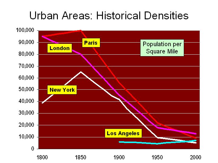
    From a Jacobsian perspective, one troubling consequence has been the reduction in the supply of older, obsolete buildings with lower economic yield requirements. Large numbers of older buildings, such as Class C office space or warehouses, have been demolished and replaced, or else converted into high end uses such as luxury condos. This is reducing the supply of lower rent buildings, undermining one of the pillars of Jacobs foundations of diversity. She noted how the hot areas tended to move around in cities as uses were displaced. So perhaps it is unsurprising that various districts in Brooklyn, for example, have become hipster and artistic havens while Manhattan has become more uniformly upscale and placid.

    Whether or not these global city effects will ultimately lead to a self-undermining success is unknown. But the loss or upscale conversion of older and lower rent buildings in our central cities, while something to celebrate in many respects, should be a long term concern to those who care about truly sustainable urban diversity, especially if taken too far.

    This piece originally appeared as a part of the City Builder Book Club’s discussion of Jane Jacobs’s "The Death and Life of Great American Cities."

  • Development Plans for Old Hong Kong Airport Announced

    The government of the Hong Kong Special Administrative Region has outlined plans to create a "second central business district" at Kai Tak in eastern Kowloon, site of the now former international airport. Kai Tak airport was abandoned in 1998 when the new Hong Kong International Airport at Chep Lap Tok opened.

    Kai Tak is in the middle of the most dense urban development in the high income world. The government intends that the development will have 43 million square feet of office space (4 million square meters) and will cost HK$100 Billion (approximately $13 billion).

    The development would be served by a monorail, which would connect with MTR (metro) lines at Kwun Tong and to a proposed central link MTR line to the new town of Sha Tin.

    Photo: Kai Tak Airport and East Kowloon (by author)

  • How Cities Grow: Dispersion, not Densification

    Analysts occasionally note that urban areas ("cities") are becoming larger and denser. This is only half right. It is true that most of the world’s urban areas are becoming larger, with megacities like Delhi, Jakarta, Shanghai, Beijing and Manila adding more than five million people in the last decade and most other urban areas are growing, but not as fast.

    Understanding Urban Areas: However almost without exception, urban areas are getting less dense. Because there is so much confusion about city "definitions," a clarification is required. The only geography for which overall urban density can be measured is the urban area, which is the area of continuous development. The urban area is not constrained by municipal or other jurisdictional boundaries and does not include rural (undeveloped) territory, even if it is in a "central city" (such as Rome, Ho Chi Minh or Marseille, with their expansive boundaries). An urban area is also different from a metropolitan area, because metropolitan areas (as labor markets) always include rural territory, which is by definition not urban.

    1960-1990 Data: Historical urban population density is not readily available. Kenworthy and Laube were pioneers in this area, publishing estimates from 1960 to 1990 for a number of urban areas. That data indicates density losses in the more than urban areas for which they were able to develop comparable data. The world average decline was 20 percent, ranging from 15 percent in the United States to 29 percent in Europe and 33 percent in Australia. While Tokyo was doubling in population, its population density was dropping 17 percent between 1960 and 1990. While Zurich was adding 21 percent to its population, it was becoming 13 percent less dense.

    Recent Data: The dispersion continues, which is indicated by these high-income world cases:

    Today, the ville de Paris has 700,000 fewer people than at its peak, and inner London (generally the former London County Council area) has lost more than 1,500,000 people since its peak. All growth has been in lower density suburban areas in both the London and Paris urban areas.

    In the United States, urban areas with more than 1,000,000 population more than doubled in population from 1950 to 2000 (2010 data not yet available), while the population density dropped by nearly one-third. Detailed analysis indicates that this trend has continued over the past decade in New York, Los Angeles, Chicago, Dallas-Fort Worth, Seattle, St. Louis and other major US urban areas.

    The dense core city of Seoul has been losing population and all growth has been in the suburbs, which are lower density.

    The dense urban core of Milan has experience substantial population losses, while the less dense suburbs have captured all the growth.

    Dispersion is not limited to high income urban areas, with declining densities in evidence across lower and middle income nations as well. For example:

    Nearly all of the growth in Jakarta has been in the suburbs for the last 20 years, while the core has gained little in population. The net effect is a less dense, but much larger urban area, because the suburbs are not as dense.

    Nearly all of the growth for 30 years in Manila has been in the suburbs, while the core city. Again, the urban area has become much larger, but much less dense because the suburbs are much less dense.

    The dense core of Shanghai has lost population and all growth has been in the suburbs, which are lower density.

    The population in the dense core of Beijing has nearly stopped growing, with nearly all population in the suburbs, which are lower density.

    The core of Mumbai has lost population in two of the last three census periods, while all growth has been in the suburbs, which are lower density.

    The urban core of Mexico City has been declining in population since 1960 and all of the growth has been in the suburbs, which are less dense.

    The dense core city of Buenos Aires has fewer people today than in 1947, while at least 8 million people have been added to nearly 1,000 square miles of lower density suburbs.

    Urban growth continues to be overwhelmingly in less dense suburban areas, rather than in the more dense urban cores, and as a result even as urban areas grow, they become less dense. This is how cities grow.

  • Suburban “End-Times” Reality Check

    The Atlantic’s Alex Madrigal announces "The Beginning of the End for Suburban America," a wish and hope long dressed-up as reality by a well-placed few who believe that the "be – all and end – all" is living anywhere but the suburbs. This is not to suggest that there is anything wrong with living in the core urban core if that is what one wants to do. I certainly have enjoyed living part-time in the inner core of the ville de Paris for some years. At the same time, however, the behavior of people has revealed an overwhelming preference for more space. From New York to Paris and Tokyo, some people choose to live in dense urban cores and a lot more choose to live in suburbs (and exurbs).

    What data does Madrigal cite to show "the beginning of the end for suburban America"? Driving is down from a peak in 2007, also the year that employment peaked. These are not disconnected events. With the total unemployed now about equal to the number of employed workers in the New York and Chicago metropolitan areas, work trips that are not made nearly equal the decline in driving. The higher gas prices appear to have induced people (in the suburbs and in the dense cores) to make modest reductions in discretionary trips or to more efficiently organize their shopping trips.

    Madrigal also points out that in 2010 new houses were smaller than their peak (also 2007). The median house size was still larger than any year before 2005 and 100 square feet larger than 2000. Madrigal cites declining rates of demand increase for electricity.
    The connection between these trends and the suburbs is unclear. Madrigal does not separate the trends by residential geography, the more dense cores of metropolitan areas, the suburbs and exurbs of metropolitan areas and the balance of the nation. Granted, the data is not immediately available for such analysis.

    Fortunately, there is more precise data that differentiates between dense core and suburban trends. It is the United States Census, conducted every 10 years and most recently in 2010. Between 2000 and 2010, the core municipalities of the 51 metropolitan areas with more than 1 million population captured 9% of the population growth, while the suburbs and exurbs captured 91%. The suburbs actually did better in the 2000s than in the 1990s, when they accounted for only 85 percent of the growth.

    True, the relative decline of the denser cores did not resemble the disastrous decade of the 1970s. Further, the gains made by very small areas of the core over the past 10 years have been an important advance. But to suggest that the 2000s represent "the beginning of the end for suburban America" is profoundly at odds with reality.

    So, the decade of the 2000s was another false start for the heralds of the suburban "end-times." The wishing and hoping has to be delayed yet again.

  • Avent on Cities: Understanding Part of the Equation

    Ryan Avent hits a home run, strikes out and earns a "yes, but," all in the same article ("One Path to Better Jobs: More Density in Cities") in The New York Times.

    A Home Run on Housing Regulation: Avent rightly notes that the land-use and housing regulations of metropolitan areas like San Francisco have not only driven housing prices higher, but also negatively impacted economic growth. Studies in the UK, the US and the Netherlands have demonstrated that significant restrictions on land use (called smart growth or urban containment) lead to reduced employment and economic growth in metropolitan areas. His comparison to OPEC is "right on" – that metropolitan areas like San Francisco have squeezed the supply of housing, which, of course, drives up house prices, just as restricting the supply of any good or service in demand will tend to do. Avent is also right in noting that high housing prices have driven huge numbers of people out of the San Francisco Bay Area to places like Phoenix. According to the Census Bureau, nearly 2,100,000 people moved from Los Angeles, San Francisco, San Diego and San Jose between 2000 and 2009 to other parts of the country.

    Striking Out on Density: The strikeout results from assumptions that are patently wrong. Cities (urban areas) do not get more dense as they add population. They actually become less dense. For example, the New York urban area has added 50 percent to its population since 1950, yet its population density has dropped by 45 percent (Figure 1). Between 2000 and 2010, most metropolitan population growth, whether in San Francisco, New York, Phoenix, Portland or Houston, was in the lower density suburbs (see: http://www.city-journal.org/2011/eon0406jkwc.html ). The same dispersion is occurring virtually around the world (see: http://www.demographia.com/db-evolveix.htm), from Seoul, to Shanghai, Manila and Mumbai. Rapid urban growth would mean even further dispersion and lower densities, not the higher density neighborhoods Avent imagines. Nonetheless, allowing the more affordable detached housing that people prefer would likely lead to stronger economic growth and more affluent residents in the San Francisco and other over-regulated metropolitan areas.

    A "Yes, But" on Productivity: Any comparison of incomes between metropolitan areas needs to take into consideration the cost of living. For example, the San Francisco Bay Area (San Francisco/San Jose) is one of the most expensive places to live in the country. The median house price is more than 2.5 times that of Phoenix, after accounting for income differentials. Avent does not control for the difference in the cost of living, which is largely driven by the higher cost of housing. The lower cost of living neutralizes much of the impact of lower incomes (such as in Houston) in metropolitan areas like Houston, Dallas-Fort Worth, Indianapolis, etc., where the OPEC model has not been applied to land use regulation.

    Finally, even controlling for the cost of living, there are substantial exceptions to any density-productivity thesis. For example, some of the greatest productivity gains information technology have come out of the Seattle area, which is the least dense major urban area in the 13 Western states, less dense than Houston, Dallas-Fort Worth and Phoenix. Even more impressively, Seattle’s urban density is barely one-half that of New York or San Francisco (Figure 2), yet its gross domestic product per capita is higher than New York and within 2 percent of San Francisco/San Jose. Seattle’s substantial contribution to the nation’s productivity has occurred while its population density was declining nearly 15 percent (since 1980).  

    Avent, like many analysts before appears to presume that population growth means higher densities. In fact, urban areas grow by dispersing, not densifying.

  • Despite Exhortations, San Antonio Suburbanizes

    "Despite years of effort by city leaders to revitalize San Antonio’s downtown neighborhoods, thousands of residents flocked to sprawling subdivisions on the far North and West sides in the past decade, while the inner city lost residents."

    That is how John Tedesco, Elaine Ayala and Brian Chasnoff of the San Antonio Express-News described the continuing dispersion of the San Antonio metropolitan area’s core Bexar County in an analysis of census tract population trends between 2000 and 2010 (we had reported more generally on the continuing dispersion of San Antonio a few months ago).

    Referring to the "siren song of the outlying suburbs," the authors note that the strongest growth in Bexar County occurred in suburban areas outside the outer beltway (the "Anderson Loop" or state route 1604). The growth, largely on the north and west sides of the county was nearly one-half of total county growth. At the same time, the inner city lost population.

    The Express-News analysis indicates that the population increased 233 percent in the northern and western areas outside the Anderson Loop. Inside the inner loop (Interstate 410), the population increased 7 percent. This includes the inner city area, where the population declined three percent. In the rest of the county (between the inner and outer loops and the outer suburbs of the east and south), the population increase was 24 percent.

    Outside core Bexar County, the metropolitan area added 34 percent to its population, more than any of the three major sectors of Bexar County.

    The reporters noted that "Every San Antonio mayor who served in the past decade preached the virtues of life in the inner city. For many people, it’s an appealing message — in theory. “Most people agree,” former Mayor Phil Hardberger said. “And then they drive out beyond 1604 to their houses.”

    Norman Dugas, a residential subdivision developer and past president of the Real Estate Council of San Antonio told the Express-News “The reality is, market forces are much more important than any planning emphasis or desire to shape development.” Put another way, "preaching" is not enough. People will likely follow their preferences unless forbidden to do so, which is regrettably a policy direction in some places.
    Subsidies to the core areas (often plentiful) and exhortations by public officials (few, if any of whom have themselves moved permanently to the inner city from the suburbs) are unlikely to change how people prefer to live.

  • “A Cloud of Contagion”: States, Cities, and Federal Default

    The Pew Center on the States has released a new report examining the impact a potential federal default would have on state and municipal governments. The picture isn’t pretty.

    According to Pew, “A federal default could have a serious impact on states and cities by constricting their borrowing and budgets while they are still feeling the aftershocks of the Great Recession.” Loss of faith in federal debt securities could have a knock-on effect on government debt at all levels, causing jittery ratings agencies to downgrade state and local credit ratings in turn. One ratings agency, Moody’s, has already warned that up to 7000 municipalities could see their bond ratings lowered in the wake of a federal default, and has placed five currently AAA rated states on a downgrade watch list. Ratings downgrades would lead to increased borrowing costs for state and local governments, restricting their long-term ability to finance desperately needed infrastructure upgrades.

    In addition to raising borrowing costs, a federal default could also directly impact federal program dollars currently allocated to state and local governments. According to Pew, such transfers amounted to “$478 billion in 2010 alone.” States and municipalities, already stressed by years of budget challenges, might suddenly find themselves even more cash strapped. In addition, the report points out that the suspension of federal payments to individuals, such as social security recipients and government contractors, could cause a drop in state and local tax receipts as individual incomes drop and commerce slows. While Pew feels states and local governments are “highly unlikely” to face a shutdown as a result of a federal default, they could be left scrambling to find alternative funding sources to cover already budgeted expenses they were expecting to meet with federal support.

  • More Hyperbole on Ghost Cities in China

    The so-called Chinese "Ghost Cities" have been the subject of a number of articles in recent months. There appears to be some truth in the reports, such as in the building of a near empty new city in Inner Mongolia (Ordos). There is also a good deal of hyperbole.

    A recent article ran in the Business Insider, entitled "New Satellite Pictures of China’s Ghost Cities," which relied principally on satellite images, some quite old. Somewhat more proximate (as on-the-ground")  pictures are provided and linked in this article. They show that at least two of the Ghosts have risen from the dead (or they may never have been dead at all).

    Changsha, Hunan: Changsha is the rapidly growing capital of Hunan province, adding nearly 50 percent to its urban districts between 2000 and 2010 (even greater growth than in the US growth leaders, Las Vegas and Raleigh). The Business Insider article displays a satellite image showing huge areas of construction both to the northeast and to the west of the urban area.

    When planning a 2009 trip to China, I chose to visit Changsha because of the extensive construction shown in this very same satellite image. In my continuing satellite image research on urban areas, especially relating to  Demographia World Urban Areas, I noted that this appeared to be the most extensive construction in the nation. A number of photographs are included inour Changsha Rental Car Tour,  which were taken in September 2009.

    On a rainy and quiet Sunday afternoon I took a tour of the northeast construction area and found that much of the construction had been finished. Moreover it was obvious from both the traffic and the open shopping centers and shops that this was anything but a "ghost city" (see photograph, above).

    The next day I took a similar trip to the western construction area. As in the northeast, much of the construction was complete and the communities were alive.

    Zhengzhou, Henan: Zhengzhou is also rapidly growing even faster than Changsha (over 60 percent in 10 years) and is the capital of Henan province. The article displays multiple satellite images of the Zhengzhou New Area. Because of a previous article in the Daily Mail, I took the opportunity on a recent trip to visit the Zhengzhou New Area and file a report. The Zhengzhou New Area is alive.

    The Business Insider also indicates an unfamiliarity with Chinese geography.

    Outside Jiangsu? A couple of the photographs referred to empty developments as being "outside Jiangsu," as a Westerner might describe a development as being outside Phoenix or Omaha. However Jiangsu is not an urban area or city, it is a province. Thus, to refer to a development as being outside Jiangsu is akin to referring to a development as being outside Arizona or Nebraska.

    Changsha Already Twice as Large as Los Angeles? The Business Insider also advises us that Changsha is already twice as big as Los Angeles. In fact, there are no comparable geographies between Los Angeles and Changsha that could make such a statement even close to accurate. Regrettably, many writers and much of the press make comparisons between China and other nations without the remotest idea of the meaning of the geographical terms they are using. Here are a couple of ways that Los Angeles and Changsha can be compared.

    1. Central municipality: The central municipality or core city of the Los Angeles area is the city of Los Angeles. It has a population of approximately 3.8 million people, but accounts for less than one third of the population of either the metropolitan area (functional area or labor market area) or the urban area (physical area or area of continuous development). Strictly speaking, there are no central municipalities in China, because the regions or prefectures are themselves municipalities. It is as if the city of Los Angeles comprised both Los Angeles and Orange counties. Chinese municipalities are divided into districts and if a comparison were to be made at the central municipality level, Changsha’s central district would have to be used. This would be the district (qu) of Furong, which has a population of 500,000 people, about 1/8 that of the city of Los Angeles.

    Core city comparisons are fraught with difficulties. This is illustrated by Melbourne, which had little more than 70,000 people in the last Australian census, approximately two percent of the metropolitan population. The 2010 US Census showed Melbourne, Florida to be larger.

    2. Urban Area: The one level at which they valid comparison could be made is the urban area, or the area of continuous urban development. The latest data for Los Angeles (2000) indicates an urban area population of 11.7 million people. The 2010 US Census counts for the Los Angeles area suggest that the urban area total, once released will be little higher than the 2000 figure.

    Based upon the 2010 census data, the next edition of Demographia World Urban Areas will estimate the Changsha urban area at approximately 3,000,000 people. Thus, by the urban area metric, Changsha has a population approximately one-quarter that of Los Angeles.

    It is possible that Business Insider like others, compared the population of the central city of Los Angeles (3.8 million), which is only part of the urban area to that of the Changsha municipality (7 million), which has more than double the population of the Changsha urban area and covers at least 25 times as much land area (virtually all it rural). They are not the same thing.

    —–

    Photograph: In the northwestern Changsha "ghost city:" September 2009 (by author)

  • Which Modes are “Multi-Modal” & Enhance Mobility?

    One thing that makes Smart Growth appealing is its language.  Terms like “livability” and “transit-oriented development” sound engaging, and “smart” growth is, frankly, self-flattering for its acolytes.  On transportation matters, advocates rarely declare their intent to reduce roadway capacity and divert money to transit projects (along with other auto unfriendly policies).  Instead, they say they are pursuing a “multi-modal” strategy to promote “transportation choice.”

    But what are acceptable modes in a multi-modal strategy?  And do all choices equal greater mobility?

    In Boston, some enterprising businesses have been renting out Segways – those futuristic, gyro-balanced transporters.  Tourists find them easy to ride and extremely convenient for scooting around the historic landmarks on the city’s wide sidewalks.  But residents see them as a nuisance, so the 13-member Boston City Council has voted unanimously to ban them from city sidewalks.

    The Segway is certainly another mode of travel.  Shouldn’t the Boston City Council, which promotes multi-modal transportation, embrace the Segway?

    Those favoring the ban don’t necessarily want the Segways to disappear from the city.  They want to move them onto roads where tourists unfamiliar with Boston’s road network can jostle with hurried commuters in 4,000 pound cars and even heavier buses and commuter rail cars.

    Like cars, Segways provide motorized transport for individuals, and its self-balancing upright design makes it more compact and maneuverable than a bicycle or moped and, thus, more suitable to mix with pedestrians on the sidewalk.  And like roads, sidewalks are inherently multi-modal and can accommodate more than just foot traffic.

    When planners and progressive politicians bark the virtues of “multi-modal” and “transportation choice,” they are usually just pushing taxes and subsidies for mass transit, especially rail transit.  Unfortunately, clever rhetoric too often trumps critical thinking.

    For example, light rail transit is considered by many to be the apogee of an urban transportation system, but replacing existing bus lines with rail lines does not necessarily enhance mobility but simply substitutes one form of collective transport for another.

    Furthermore, in most communities the only mobility choices people have are private transport (automobiles) or public mass transport (buses or rail).  Expanding transportation choices would mean introducing private competition for mass transit services and public support, such as mobility vouchers for low income people, for private transport (e.g., Zipcars or taxis).

    As cities continue to face bleak budget forecasts, the costs of different travel modes will remain an important consideration.  Because mobility is intricately tied to economic prosperity, it’s equally important to understand which modes enhance mobility and which ones merely give it lip service.

    Ed Braddy is the director of the American Dream Coalition, a non-profit organization promoting freedom, mobility and affordable homeownership.  He can be reached at 352-281-5817 or at ed@americandreamcoalition.org.

  • Turn the Focus Towards Australia’s Regional Towns

    Too much property reporting and media attention is given to our capital cities, and not enough effort is spent analysing our regional towns. 

    As a result, too few investors understand Australia’s regional potential.  Right now, not only are many of our regional centres at the bottom of their cycle, but larger, long-term trends are at play.  Indeed, regional Australia is on the cusp of some big demographic changes. 

    Here’s why:  In recent years our capital cities have attracted around two-thirds of Australia’s population growth, with many of these new residents settling in the outer suburbs. Our capitals also generated the lion’s share of employment. 

    But over the last twelve months or so, this trend has shifted, with close to two-fifths of our new jobs now being created away from our major cities and in regional towns.  Past trends suggest that population growth will follow. 

    Deteriorating lifestyle (and rising costs) – in our three major capitals, at least – is likely to add further momentum to this new regional push.

    It’s not too hard to understand why Australia’s regional areas are sometimes overlooked.  A quick look at the demographics of Australia reveals a country the same size as mainland USA, or 20 times the size of Japan, with only eight capital cities throughout its eight states and territories.  This is one of the most urbanized countries in the world, where only 15% of the population resides in rural areas and a vast interior.   

    This week, regional focus has come under the microscope with the unveiling of the 2011 Federal Budget by Australia’s Deputy Prime Minister and Treasurer, Wayne Swan.   The Government plans to flood regional areas with 16,000 skilled migrants via the introduction of new initiatives to encourage skilled migration to regional areas.

    Additionally, regional areas are set to receive critical infrastructure upgrades to hospital and health services, and funding to support strategic planning and growth. 

    Astute property buyers should start to look beyond the capitals for investment opportunities.  The big winners in this regional resurgence will most likely be the resource towns – the “muscle towns”, as Bernard Salt recently called them. 

    By this, we don’t mean the fly-in-fly out places like Moranbah, but places critical to the delivery of iron ore, gas and coal – like Wollongong, Newcastle, Gladstone, Surat Basin (Toowoomba) and Townsville.  Expect big things in these regions.  Two thirds of the new jobs created across Queensland last year were in the Gladstone region alone.

    Regional Australia is to become a whole lot more.