Tag: density

  • Visualizing Houston’s Population Density

    Population density may sound like the most mundane of metrics, a column heading in a city planner’s spreadsheet, but in cities across the U.S. it’s been a source of cultural controversy, guiding where people move and why.

    To those seeking a more urban lifestyle, “density” implies walkability, car-free transit, and cosmopolitan culture. To others, “density” equates to crowds, cramped quarters, and the inability to find parking. The debate arises around nearly every planning decision under consideration in cities like Charlotte, often devolving into vicious debate.

    Where these debates often breakdown is when it comes to the relative nature of population density: How dense is ‘dense’? Is Houston dense? We should all be able to agree that New York is dense, right? Well, not compared to Paris, let alone Manila.

    In order to put Houston’s density in perspective, we put together a series of visualizations showing how large Houston would be if it were as dense as other cities.

    If Houston’s population lived as close together as New York’s does, how much space would they take up? Compared to cities like Mumbai, or even Los Angeles, Houston is a sprawl, while compared with Jacksonville and Anchorage, Houston is practically Manhattan.

    Note that Houston’s city limits were used for this visualization, not the metro area. While some readers may object to the exclusion of surrounding locales, metro areas are not as well defined as city limits and that is often a matter of debate itself.

    houston-tx-density-sparefoot-houston-storage-units

  • Why Intensification Will Not Solve the Housing Affordability Crisis

    Analyst Phil Hayward of Wellington, New Zealand provides a provocative perspective on why urban intensification (densification in the urban cores) is incapable of compensating for the huge house price increases attributable to urban containment boundaries. Writing on Making New Zealand for Urban Planning that Works, he notes that “planners and advocates and politicians and even economists, are making an assumption that urban intensification is a potential route to housing affordability.”

    The assumption involves changing zoning so that “X number of housing units” can be constructed in existing urban locations “instead of X number of housing units” on pristine ex-urban land. The latter is assumed to be an evil to be avoided, and that the former is a perfect substitute in terms of “sufficient housing supply to enable affordability.

    Hayward continues:

    Common sense tells us that there are quite a few potential problems with this assumption. For example, NIMBYs will obstruct the intensification and reduce the rate of housing supply so the policy will fail. Therefore, what we need is the removal of NIMBY rights of protest and appeal, and the policy will then work.

    Hayward’s analysis suggests that:

    And generally, the data runs in that direction – not only does intensification within a regulatory boundary "not restore affordability", it seems that the more density you “allow”, the higher your average housing unit price gets. The correlation runs the opposite way to the assumption.

    Indeed, “Paul Cheshire and his colleagues at the London School of Economics believe this is due to the ‘bidding war’ at the margins of each income-level cohort of society, for ‘slightly more space,’" according to Hayward. “But when a market is allowing people to consume "as much space as they want", which has only really occurred in the automobile era, the “bidding war” effect is absent.”

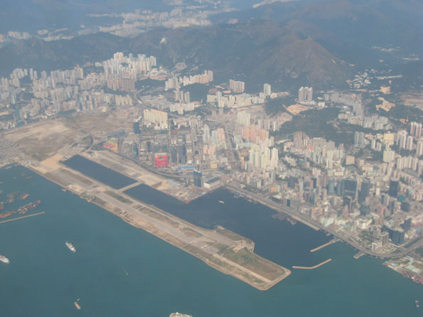
    Boston and Atlanta provide powerful examples.

    …(The) difference is that Boston has de facto growth boundaries / green belts while Atlanta does not. The ironic implication is that fringe growth containment pushes median multiples up less, when there are severe restrictions against density – otherwise Boston should be the most expensive city in the data, not Hong Kong. The evidence suggests that this is because there is a total absence of “bidding war for slightly more space” – everyone has "more than they want" already. The median multiple of 6 rather than 3, represents the effect of demand for "living in Boston", period, and they simply don’t provide enough houses to keep the median multiple down like Atlanta does (in the face of staggering population growth in Atlanta, by the way).

    Perhaps the most important conclusion is that “there is no evidence that any city anywhere in the world has ‘freed up intensification processes’ enough to result in floor space being built faster than site values inflate.

    The bottom line is a mistaken impression that high density housing “will remain available as a substitutable option to suburban family housing even if the latter is forced up in price deliberately by central planner’s policies. The lesson that needs to be learned urgently, is that this is impossible; the two things are inter-related.”    

    But when a market is allowing people to consume "as much space as they want", which has only really occurred in the automobile era, the “bidding war” effect is absent. The evidence supports this, with most median-multiple-3 cities being from 600 to 2500 people per square km. Another interesting case study would be Liverpool; it lost approximately 50% of its population from the 1950’s to the 2000’s (similar to Detroit) – yet its median multiple is over 7. And its density is still 4,400 per square km (presumably it would have been double this, or more, in 1950). This is prima facie evidence that 4,400 people per square km within a growth boundary, are still going to be dissatisfied with their living space, to the extent that they will be engaging in an unwitting bidding war against each other for a little more of it. Of course under these conditions, the lowest socio-economic cohort is denied all options other than crowding tighter and tighter in rented accommodation or even illegal “living space”. In UK cities, rental advertisements include options like a ¼ share in 2 rooms, with communal access to kitchen and bathroom shared by even more tenants in further rooms. In median-multiple-3 housing cities, the same real rent would apply to a whole house of reasonable size and standard. 

    There might be other policy mixes by which housing supply within a growth boundary could be made the means of keeping housing affordable, but publicly and politically, the debate is nowhere near tackling the complexities involved.

  • Suicide: Sprawl Not Guilty

    Atlantic Cities reports on research indicating an association between suicide and lower density, in an article entitled “The Unsettling Link Between Sprawl and Suicide.” Actually, there’s no reason to be unsettled, at least with respect to urban areas and their densities. The conclusions apply to rural areas, not urban areas.

    Above the 300 persons per square kilometer, or 780 persons per square mile, the authors found no association. The authors of the study note, “above this threshold … the suicide rate remains fairly constant."

    The US Census Bureau standard for urbanization is 1000 people per square mile or more, which is similar to the international standard of 400 persons per square kilometer. Even the suburbs of extremely low-density Atlanta and Charlotte have to reach the 1,000 persons per square mile threshold to be in the urban areas.

    This research, while interesting, has nothing whatever to do with the urban form.

  • Seeking Community in Vancouver’s High Rise Ghost Towns

    The Province in Vancouver reports (in "15% of downtown Vancouver condos sit empty, turning areas into ghost towns: Study") that "much of the downtown core is starting to look like B.C.’s ghost towns — with apartments languishing empty, businesses closing down and residents not feeling the sense of community they bought into." The study, by University of British Columbia (UBC) planning professor Andy Yan, indicates that the problem is most pronounced outside the long-established high-rise district of the West End. He notes that in Coal Harbour, well located adjacent to the downtown area along Burrard Inlet, approximately 25% of the condominium units are unoccupied.

    UBC economics professor Tour Somerville suggests that the number may even be higher, at 65% vacant, including both unsold units and units that have been purchased but not occupied by their owners. Vancouver has had an unusual amount of investment from mainland China, especially as that nation has substantially limited the purchase of condominium units for investment purposes.

    Reporter Mike Reptis of The Province notes the difficulties for businesses in the area, indicating that "it’s a problem to local small business owners and residents — especially in Coal Harbour — who have bought into the neighbourhood expecting more of a community, and more business."

    A long time convenience store manager complained that “foot traffic has slowed" and "local people can’t afford (to live here)," concluding that "small grocery stores are closing up" and "A lot of small companies are closing up.”

  • Infographics: The Decongestion of Manhattan, New York Walking Commutes

    Jim Russell pointed me at an interesting article about densification vs. de-densification over at the Urbanization Project at NYU Stern. It contains this very interesting map of the change in census tract densities in Manhattan over the century between 1910 and 2010:


    Walking Related Commutes

    Streetsblog, in an article covering the annual NYC DOT scorecard, included this graphic of the percentage of commutes that include walking as a core component (e.g, transit) in various parts of New York:

    This post originally appeared at The Urbanophile.

  • Attack on the Suburbs: California Senate Republican Caucus Report

    Differing views on the future of California urban areas are the subject of a California Senate Republican Caucus report (Briefing Report: Attack On The Suburbs: SB 375 And Its Effects On The Housing Market).

    The report details differing views on the future of California urban areas as described by University of Utah Professor Arthur C. Nelson in a report for the Urban Land Institute with those of newgeography.com authors Joel Kotkin and Wendell Cox in recent editions of The Wall Street Journal.

    Nelson’s view is largely that the market for detached housing in California is in decline. Senate Bill 375’s planning mandates are being interpreted to virtually ban further construction of detached housing in the state’s metropolitan areas.

    However, if Nelson’s analysis were right, there would be no need for legislative intervention since people would not buy detached housing. In fact, however, the demand for detached housing remains strong. Between 2000 and 2010, detached housing accounted for 80 percent of new housing additions in California’s major metropolitan areas.

    Critics of Senate Bill 375 market interventions that would seek to steer the market toward hyper density housing (20 to 40 and more housing units to the acre) would increase traffic congestion, increase the intensity of air pollution and make California and encumber an already laggard economy.

    The report concludes: "Clearly, before the California Legislature decides to take over the community planning duties of local governments and engage in social experimentation with the housing market, it should perhaps look at both sides of the argument to see if the experiment will be successful." 

  • Making Stuff Up at Atlantic Cities

    Editor Sommer Mathis over at The Atlantic Cities has taken to making stuff up. In a recent post she reported on a dispute in the city of Seattle over minimum parking requirements relating to multi-unit buildings. She said:

    Defenders of suburban-style development like Wendell Cox and Joel Kotkin would argue that these young people just don’t understand how their lives and desires are going to change once they start families. Single-family, detached homes with a quarter acre of land and two cars in the garage are suddenly going to look a lot better to all these idealistic, bicycle riding twenty-somethings once the reality of parenthood sets in.

    Kotkin and Cox also worry that developers and city planners rushing to meet the youth-driven demand for denser housing options that don’t necessarily include parking are shooting themselves in the foot.

    The only problem is that I have never commented on minimum parking requirements. I checked with Joel Kotkin and he advises that he has never covered the issue.

    Mathis continues (after an citing a quote by Joel Kotkin article in Forbes):

    What’s funny about these assumptions is their total lack of faith in the free market.

    Of course, since our alleged positions on minimum parking requirements are figments of Mathis’ imagination, her "free market" conclusion misses the mark. Indeed, the most destructive impact on urban land markets today is urban growth boundaries and "winner picking" land use restrictions that deny people their preferences (as my Wall Street Journal piece, California’s War on Suburbia, argued on Saturday). I am most concerned about these because of their potential for hampering the metropolitan economy, interfering with upward mobility and increasing poverty (I suspect Joel would agree). Moreover, young households soon figure out that they need more than the 4th floor (or 40th floor) balcony to raise a child.

  • Census Bureau Releases Latest Take on America’s Urban Areas

    We are used to dealing with jurisdictional boundaries when assessing and comparing cities. These are often either municipal areas or metropolitan statistical areas (which are based on entire counties). But these can have little relevance to the amount of area in a given city-region that is actually urban in nature. This makes apples to apples across regions difficult.

    Once a decade though the Census Bureau gives us a more detailed look. They release definitions of so-called “urbanized areas” that attempt to look at just the amount of land that is actually urban in form. In theory this would allow for better apples to apples comparisons between regions. Unfortunately, most data is not sliced this way, so we only get this glimpse. Here’s the map of the new 2010 urbanized area definitions:

    Wendell Cox has a breakdown of the largest urbanized areas that includes density. He also published a historical review that tracks urbanized area population and density since 1950 for the largest city regions. For more thoughts on urbanized areas, see Nate Berg’s take over at Atlantic Cities.

    I don’t want to try to offer a complete analysis of this right now, but one thing that really jumped out at me was the very low densities of some southern boomtowns like Atlanta (1,707/sq. mi) and Charlotte (1,685/sq. mi.). Contrast with even Houston (2,979/sq. mi.) and Dallas (2,879/sq. mi) and see the difference. Atlanta is already showing serious signs of weakness vs. the Texas mega-metros and I wonder if this is part of the reason why. It also makes me wonder if Charlotte might someday suffer in a similar manner if its growth ever flames out.

  • New US Urban Area Data Released

    This morning the US Bureau of the Census released data for urban areas in the United States. The urban population of the US rose to 249.3 million in 2010, out of a total population of 308.7 million. Urbanization covered 106,000 square miles, representing 3.0 percent of the US land mass. Overall urban density was 2,342 per square mile (905 per square kilometer).

    The Los Angeles urban area was again the nation’s most dense, at 6,999 per square mile (2,702 per square kilometer), a slight reduction from the 7,068 figure (2,729 per square kilometer) in 2000. The most dense urban areas with more than 1,000,000 population were Los Angeles, San Francisco, San Jose, New York and Las Vegas (in that order).

    Overall, the 41 major urban areas had an average density of 3,245 per square mile (1,253 per square kilometer). The table below provides data for the major urban areas and overall data.

    United States Urban Area Data: 2010 Census
    Major Urban Areas  & Summary
    Rank Urban Area
    Population
    Land Area (Square Miles)
    Density
    Density per Square KM
    1 New York–Newark, NY–NJ–CT
    18,351,295
    3,450
    5,319
    2,054
    2 Los Angeles–Long Beach–Anaheim, CA
    12,150,996
    1,736
    6,999
    2,702
    3 Chicago, IL–IN
    8,608,208
    2,443
    3,524
    1,361
    4 Miami, FL
    5,502,379
    1,239
    4,442
    1,715
    5 Philadelphia, PA–NJ–DE–MD
    5,441,567
    1,981
    2,746
    1,060
    6 Dallas–Fort Worth–Arlington, TX
    5,121,892
    1,779
    2,879
    1,112
    7 Houston, TX
    4,944,332
    1,660
    2,979
    1,150
    8 Washington, DC–VA–MD
    4,586,770
    1,322
    3,470
    1,340
    9 Atlanta, GA
    4,515,419
    2,645
    1,707
    659
    10 Boston, MA–NH–RI
    4,181,019
    1,873
    2,232
    862
    11 Detroit, MI
    3,734,090
    1,337
    2,793
    1,078
    12 Phoenix–Mesa, AZ
    3,629,114
    1,147
    3,165
    1,222
    13 San Francisco–Oakland, CA
    3,281,212
    524
    6,266
    2,419
    14 Seattle, WA
    3,059,393
    1,010
    3,028
    1,169
    15 San Diego, CA
    2,956,746
    732
    4,037
    1,559
    16 Minneapolis–St. Paul, MN–WI
    2,650,890
    1,022
    2,594
    1,002
    17 Tampa–St. Petersburg, FL
    2,441,770
    957
    2,552
    985
    18 Denver–Aurora, CO
    2,374,203
    668
    3,554
    1,372
    19 Baltimore, MD
    2,203,663
    717
    3,073
    1,187
    20 St. Louis, MO–IL
    2,150,706
    924
    2,329
    899
    21 Riverside–San Bernardino, CA
    1,932,666
    545
    3,546
    1,369
    22 Las Vegas–Henderson, NV
    1,886,011
    417
    4,525
    1,747
    23 Portland, OR–WA
    1,849,898
    524
    3,528
    1,362
    24 Cleveland, OH
    1,780,673
    772
    2,307
    891
    25 San Antonio, TX
    1,758,210
    597
    2,945
    1,137
    26 Pittsburgh, PA
    1,733,853
    905
    1,916
    740
    27 Sacramento, CA
    1,723,634
    471
    3,660
    1,413
    28 San Jose, CA
    1,664,496
    286
    5,820
    2,247
    29 Cincinnati, OH–KY–IN
    1,624,827
    788
    2,063
    796
    30 Kansas City, MO–KS
    1,519,417
    678
    2,242
    865
    31 Orlando, FL
    1,510,516
    598
    2,527
    976
    32 Indianapolis, IN
    1,487,483
    706
    2,108
    814
    33 Virginia Beach, VA
    1,439,666
    515
    2,793
    1,078
    34 Milwaukee, WI
    1,376,476
    546
    2,523
    974
    35 Columbus, OH
    1,368,035
    510
    2,680
    1,035
    36 Austin, TX
    1,362,416
    523
    2,605
    1,006
    37 Charlotte, NC–SC
    1,249,442
    741
    1,685
    651
    38 Providence, RI–MA
    1,190,956
    545
    2,185
    844
    39 Jacksonville, FL
    1,065,219
    530
    2,009
    775
    40 Memphis, TN–MS–AR
    1,060,061
    497
    2,132
    823
    41 Salt Lake City–West Valley City, UT
    1,021,243
    278
    3,675
    1,419
    Total
    133,490,862
    41,139
    3,245
    1,253
    Other Urban Areas
    115,762,409
    65,247
    1,774
    685
    Total Urban
    249,253,271
    106,386
    2,343
    905
    Rural
    59,492,267
    3,431,052
    17
    7
    Total Population
    308,745,538
    3,537,439
    87
    34
    Share Urban
    80.7%
    3.0%
  • Development Plans for Old Hong Kong Airport Announced

    The government of the Hong Kong Special Administrative Region has outlined plans to create a "second central business district" at Kai Tak in eastern Kowloon, site of the now former international airport. Kai Tak airport was abandoned in 1998 when the new Hong Kong International Airport at Chep Lap Tok opened.

    Kai Tak is in the middle of the most dense urban development in the high income world. The government intends that the development will have 43 million square feet of office space (4 million square meters) and will cost HK$100 Billion (approximately $13 billion).

    The development would be served by a monorail, which would connect with MTR (metro) lines at Kwun Tong and to a proposed central link MTR line to the new town of Sha Tin.

    Photo: Kai Tak Airport and East Kowloon (by author)