Tag: geography

  • Five Ideas to Make America Greater

    Donald Trump’s presidential campaign was based on the notion that he could “Make America Great Again.” But beyond the rhetoric — sometimes lurching into demagoguery — the newly elected president comes to office, as one commentator suggests, “the least policy-savvy president in history.”

    To succeed, Trump must adopt innovative policies that transcend traditional right-left divides. He needs to find ways to help his heavily white, working-class base while expanding his appeal to minorities, millennials and educated people who are now largely horrified by his ascendency.

    In the short run, his biggest problem may lie with his own Republican Party establishment, which, rather than “drain the swamp,” would simply like to create one of its own. The looming presence of corporate lobbyists, swarming around the administration like hungry flies, is not encouraging at all, nor are GOP congressional plans to re-establish “earmarks.”

    The key lies not in empowering a different set of K Street parasites, but rather in reversing income stagnation. If he cannot, his triumph may prove to be no more consequential than an absurdist, Latin American-style telenovela.

    A flatter, fairer tax

    The basic instinct among many Republicans tends toward reducing taxes on their richest donors and making life easier for the ultrarich, including some on Trump’s economic team. Trump’s imperative should, instead, be to make the tax system fairer for the middle and working classes. One way would be to make a graduated flat tax that would mean that the rich, who make most of their money from investments, pay the same rate for capital gains as the rest of us do for income.

    Democrats will, no doubt, still charge Trump with being “unfair,” but, as Ronald Reagan proved 20 years ago, Americans support incentives for work if they don’t unfairly tilt conditions to the ultrarich. Main Street business owners, the most hostile constituency to the Obama administration’s policies, pay taxes based on their income and can’t manipulate the system like Apple, Google, Wall Streeters or, for that matter, real estate developers like Trump himself.

    A middle ground for immigration

    Opposition to illegal immigration helped drive the Trump campaign early on, but, outside of the GOP base, there is little support for a mass roundup of the undocumented. The vast majority of Americans, over 70 percent, also oppose “open borders.” After all, even President Obama evicted 2 million people during his two terms in office.

    Trump also can begin reordering our immigration policies toward skilled workers who are interested in becoming citizens. At the same time, Trump could score points by undermining the H1-B visa program, which allows Silicon Valley firms, along with corporations like Disney and Southern California Edison, to lay off American workers and replace them with temporary indentured servants.

    Read the entire piece at The Orange County Register.

    Joel Kotkin is executive editor of NewGeography.com. He is the Roger Hobbs Distinguished Fellow in Urban Studies at Chapman University and executive director of the Houston-based Center for Opportunity Urbanism. His newest book, The Human City: Urbanism for the rest of us, will be published in April by Agate. He is also author of The New Class ConflictThe City: A Global History, and The Next Hundred Million: America in 2050. He lives in Orange County, CA.

    Photo: Gage Skidmore from Peoria, AZ, United States of America (Make America Great Again hat) [CC BY-SA 2.0], via Wikimedia Commons

  • San Francisco Observations

    I made quite a few trips to San Francisco during the late 90s into the early 2000s, but hadn’t been back in a very long time – probably close to 15 years.

    Recently I was there for a conference and a long weekend and got to spend some time exploring the city. I won’t claim a comprehensive review, but I did have a few takeaways to share.

    1. Fewer homeless than expected. Based on the rhetoric you read in the papers, I expected SF to be overrun with aggressive homeless people. This wasn’t the case. There were visible homeless to be sure, but no more than I remember from 15 years ago and no more than I see in New York. And they were not particularly aggressive in any way.

    2. A curiously low energy city. It’s tough to judge any American city’s street energy after living in New York, but San Francisco felt basically dead. Tourist areas around Union Square and the Embarcadero were crowded, and the Mission on a Friday night was hopping, but otherwise the city was very quiet. Haight-Ashbury was nearly deserted and many neighborhoods had the feel of a ghost town. It’s very strange to be walking around a city with such a dense built fabric but so few people.

    3. San Francisco is too small to support a centralized economy. The Financial District has a number of skyscrapers, and SOMA is awash in construction – the biggest changes I observed were in this district – but central San Francisco is too small to serve as a global city business center. And the city as a whole is not big enough to support that kind of a resident base. The bottom line is that San Francisco’s constrained geography renders the construction of a CBD in the style of a Chicago or New York very difficult. Also, at only around 856,000 people – an all time record high – the absorption capacity of the city is limited. Contrast with NYC at 8.5 million, LA with 4 million and Chicago with around 2.7 million in much bigger geographies. Also, the transport geography of San Francisco does not include the type of massive commuter rail system that NYC, London, Chicago, etc. have. In short, I don’t see SF having the capacity for a much greater degree of employment centralization.

    4. Major construction is undesirable in San Francisco. As I’ve written before, San Francisco is one of America’s most achingly beautiful cities with a very unique building stock. It’s also, like Manhattan, mostly fully developed. So new construction in most places would involve demolition of the existing building stock. No surprise SOMA is where the construction is, because there’s room to do it and/or lower quality buildings to replace. To make a serious increase in the quantity of residential or office space would involve significant damage to the character of the city and would not in my view be desirable. Nor, given the point above about its small size, is it likely to make much of a difference anyway. It’s hard to see how the city of San Francisco itself changes its trends without an economic pullback.

    5. San Francisco doesn’t feel like it has the services of a high tax city. Taxes are high in San Francisco, but it many ways it doesn’t feel like it. In New York, our taxes are high, but the level of services is highly visible, at least in Manhattan. Just as one small example, SF’s storm drains were often partially blocked with leaves, and there were pools of standing water even on Market St. In NYC, BID employees or building supers regularly clear storm drains and sweep water into sewers. Our parks are in better shape. I was surprised to see that SF still has curbs with no ADA ramps. In short, while the city is beautiful and such, it doesn’t radiate the feel of high services.

    6. Barrier and POP transit system. I ran into a curious situation while riding transit. Muni, the city’s transit agency, has a light rail system called Muni Metro. It runs as a subway under Market St. Because it runs on street elsewhere, the trainsets are pretty short. I rode the subway portion, which has a barrier system. But then on the train my ticket was checked again by a conductor. Why have barriers if you are running a POP system on top of it? I’m glad I saved my ticket.

    7. San Francisco Opera. I attended my first opera in San Francisco. The San Francisco Opera is a very globally respected company. The opera, Janacek’s The Makropulous Case, was very good. It was well-patronized but there were plenty of empty seats too. It has the feel of the Lyric Opera of Chicago, where the majority of attendees are subscribers. The average age was very high – much higher than the Met Opera, which although suffering a serious attendance problem draws quite a few young people. The SF Opera’s patron base is getting up there. I also took a look through the program. I did not see a single tech company on their list of corporate sponsor, nor did I see any tech names I recognized on their major donor list. Opera in San Francisco appears to be an old money affair, with the emphasis on old. This doesn’t bode well for the future of this flagship cultural organization if it can’t find a way to tap into younger attendees and donors. I’d have to caveat this somewhat given that my investigation is very limited. But this is a trend affecting many similar organizations.

    Aaron M. Renn is a senior fellow at the Manhattan Institute, a contributing editor of City Journal, and an economic development columnist for Governing magazine. He focuses on ways to help America’s cities thrive in an ever more complex, competitive, globalized, and diverse twenty-first century. During Renn’s 15-year career in management and technology consulting, he was a partner at Accenture and held several technology strategy roles and directed multimillion-dollar global technology implementations. He has contributed to The Guardian, Forbes.com, and numerous other publications. Renn holds a B.S. from Indiana University, where he coauthored an early social-networking platform in 1991.

  • Cat and Mouse in Frogtown

    A friend recently expressed an interest in how some cities are reforming their land use regulations. “I mean, there are places like LA that say they’ve thrown out the code books and are rewriting their zoning.” My short response was… No. The reality is that the city plays an expensive and byzantine game of cat and mouse with each individual neighborhood.

    screen-shot-2016-09-20-at-12-46-43-am


    There’s a little sliver of brassiere shaped land wedged between the Los Angeles River and the Golden State Freeway that sums up a lot of what constitutes the land use regulation process in LA. When poor Mexicans were forcibly removed in order to build Dodger Stadium in the late 1950’s they resettled in this inexpensive semi-industrial zone called the Elysian Valley, which is also commonly known as Frogtown.

    screen-shot-2016-09-24-at-5-53-58-pm

    screen-shot-2016-09-24-at-5-54-44-pm

    screen-shot-2016-09-25-at-5-12-11-pm

    screen-shot-2016-10-01-at-4-30-10-pm

    It’s been a solid working class neighborhood for decades. Families have long managed to own modest homes and live in respectable obscurity among the auto body shops, plumbing supply warehouses, and municipal maintenance facilities.

    screen-shot-2016-10-01-at-8-26-31-pm

    screen-shot-2016-10-02-at-2-15-09-pm

    screen-shot-2016-09-25-at-5-35-22-pm

    screen-shot-2016-09-25-at-5-35-49-pm

    screen-shot-2016-09-25-at-5-49-55-pm

    screen-shot-2016-09-25-at-6-00-20-pm

    In recent years the adjacent neighborhoods of downtown Los Angeles, Echo Park, Silver Lake, Atwater Village, and Glassell Park (all previously ignored and undervalued) have become newly fashionable and prohibitively expensive. Pent up market demand acts like a balloon – if you squeeze the middle the ends bulge. In this case home buyers, renters, and businesses have scoured the area looking for alternatives. Frogtown is a centrally located and relatively affordable compromise.

    screen-shot-2016-10-02-at-9-02-47-pm

    screen-shot-2016-10-02-at-9-20-26-pm

    screen-shot-2016-10-02-at-9-21-04-pm

    Design firms, architects, photographers, tech incubators, high end specialty fabricators, and other such enterprises have moved in to the nondescript buildings of Frogtown. If you’re willing to celebrate concrete block walls and corrugated steel as honest industrial materials you can create the trendy Dwell look with paint and landscaping on the cheap. Compare this process with the expense of restoring a more exotic historic property in a tony neighborhood.

    screen-shot-2016-10-02-at-9-13-11-pm

    screen-shot-2016-10-02-at-9-09-21-pm

    screen-shot-2016-10-02-at-9-08-32-pm

    screen-shot-2016-10-02-at-9-07-54-pm

    screen-shot-2016-10-02-at-9-07-03-pm

    screen-shot-2016-10-02-at-9-06-32-pm

    Art Yanez is a Los Angeles native and the son of immigrants. He’s also the principal of FSY Architects. He purchased three contiguous parcels in Frogtown and created a campus for his firm.

    screen-shot-2016-10-17-at-5-18-27-pm

    screen-shot-2016-10-02-at-9-15-37-pm

    screen-shot-2016-10-02-at-9-15-50-pm

    screen-shot-2016-10-02-at-9-19-49-pm

    screen-shot-2016-10-02-at-9-06-02-pm

    screen-shot-2016-10-02-at-9-05-53-pm

    screen-shot-2016-10-02-at-9-12-49-pm

    screen-shot-2016-10-02-at-9-04-15-pm

    The space incorporates pre-existing industrial warehouses as well as new construction with shops and offices that are now rented for supplemental income. The architecture firm’s own offices are currently oversized to accommodate anticipated expansion as business continues to ramp up. But construction is a cyclical industry, so the space can be subdivided and rented during future downturns.

    screen-shot-2016-10-02-at-9-12-41-pm

    screen-shot-2016-10-02-at-9-16-58-pm

    screen-shot-2016-10-02-at-9-11-58-pm

    screen-shot-2016-10-02-at-9-12-06-pm

    The new building achieves the legally required off street parking standard as well as the fire marshal’s demand that a full size fire engine be able to drive around the entire structure in an emergency. The parking is convenient (this is Los Angeles after all), but the outdoor space does double duty as a plaza for human activities on occasion. Strings of cafe lights, movable furniture, potted plants, and people transform the place quickly and easily.

    screen-shot-2016-10-02-at-9-21-21-pm

    screen-shot-2016-10-02-at-9-03-00-pm

    screen-shot-2016-10-02-at-9-16-40-pm

    screen-shot-2016-10-02-at-9-14-17-pm

    screen-shot-2016-10-02-at-9-02-32-pm

    screen-shot-2016-10-02-at-8-02-41-pm

    screen-shot-2016-10-02-at-8-02-50-pm

    Part of FSY’s strategy was to create a place that would activate the entire community, not just a building containing offices. The initial concept involved repurposing shipping containers and pressing them into service as small shops. The building code wouldn’t permit that so a stick built version mimics the container look and scale. Actual containers are parked in back and are used for low cost storage. Local artists were invited to install distinctive motifs for the exterior of the corner cafe. All of this was as-of-right construction within the established city code.

    screen-shot-2016-10-01-at-4-30-34-pm

    screen-shot-2016-10-01-at-8-24-41-pm

    screen-shot-2016-10-01-at-4-30-58-pm

    screen-shot-2016-10-01-at-8-27-09-pmscreen-shot-2016-10-01-at-8-25-40-pm

    screen-shot-2016-10-01-at-8-23-39-pm

    For the last century the Los Angeles River has been a concrete industrial drainage canal sealed off by barbed wire fences and cinder block walls. Most people in LA have no particular relationship to the “riverfront.” But that’s changing as city officials have announced a billion dollar program to transform the river into a ribbon of green and blue public amenities lead by none other than starchitect Frank Gehry.

    screen-shot-2016-09-24-at-5-55-16-pm

    screen-shot-2016-09-24-at-5-55-37-pm

    screen-shot-2016-09-24-at-5-55-51-pm

    The success of small infill developments in Frogtown along with the city’s plans to transform the river have attracted large scale production developers. Previously ignored sites began to sprout upscale apartment buildings and condo complexes on dead end streets at the river’s edge.

    This process was viewed with scorn by existing property owners and community organizers who haven’t forgotten how their families were bulldozed to make way for Dodgers Stadium. So they lobbied for new regulations to make it harder to build anything new and to work around the perception that political figures are corrupt and on the take for developer’s money. The new regulations now make projects like Art Yanez’s building non-conforming and subject to special review processes for height, bulk, and so on.

    The result is that now only very small projects can be built as-of-right, and only very large and expensive projects can overcome the newly implemented regulatory hurdles. All the incremental in-between projects that might have been built are now much less viable and far more expensive to push through. This is what land use policy actually looks like on the ground.

    John Sanphillippo lives in San Francisco and blogs about urbanism, adaptation, and resilience at granolashotgun.com. He’s a member of the Congress for New Urbanism, films videos for faircompanies.com, and is a regular contributor to Strongtowns.org. He earns his living by buying, renovating, and renting undervalued properties in places that have good long term prospects. He is a graduate of Rutgers University.

    Top photo: John Sanphillippo

  • Were Urban Freeways a Good Idea?

    It’s almost a truism in urbanist circles that construction of urban freeways was a bad idea.

    Indianapolis Monthly magazine takes a somewhat more charitable view in its retrospective on the 40th anniversary of the completion of the downtown “inner loop” freeway.

    “But even before its grand opening, the inner loop—31 miles of interstate within I-465, built at a cost of nearly $300 million—had begun paying downtown dividends. Real estate values around the superhighway increased in the early 1970s, reversing a 35-year decline, and Mayor Hudnut also credited the road with stimulating such projects as the Hilton Hotel, the Indiana National Bank building, and the $150 million expansion of Eli Lilly & Co.

    Hudnut predicted the new freeway would spur 20,000 new jobs, and state legislators embraced the spirit: In 1973, when a federal reimbursement slowdown threatened to add 10 years to its completion date, they fronted the money for the last leg of I-65/I-70.”

    The conventional wisdom is that downtown freeways were unmitigated disasters. It says they destroyed vast tracts of urban neighborhoods, with a racist targeting of black ones, then remained as huge barriers to redevelopment.

    The Indy Monthly article acknowledges the downsides of the construction:

    “But little relief awaited the neighborhoods that were carved up for the inner loop. The project displaced a total of 17,000 residents, including 6,000 from Fountain Square (one-fourth of the population).

    Linda Osborne, owner of Arthur’s Music Store, remembers Fountain Square as a vibrant full-service community during the 1950s and early ’60s. “There were theaters, grocery stores, shoe stores—all the things you have in a small town,” says Osborne, whose family business opened in 1952. Interstate construction, however, dug a wide channel that isolated Fountain Square from downtown. Then as now, a Virginia Avenue bridge carried traffic over the chasm, but the commercial district soon tanked, Osborne says.”

    I previously posted an article documenting the destruction in Fountain Square. It features pictures from Historic Indianapolis, including this one showing the scale of the destruction.

    historic indianpolis

    I don’t have Fountain Square’s demographics at the time, but what evidence I do have suggests it was a largely white community, which it remains to this day. So in this case the place with the most destruction wasn’t a minority area.

    Indy Monthly also points out the example of downtown Ft. Wayne. That city decided to go with a bypass option rather than a downtown alignment. The result was that they did indeed prevent neighborhoods from being destroyed, but those neighborhoods and the city’s downtown severely declined anyway. While there are some interesting things going on downtown Ft. Wayne to be sure, it’s unarguable that Indy’s downtown is on a completely different plane of development, though to be sure Indy is a much larger city.

    In fact, this is the pattern we see. Urban decline happened pretty much everywhere, urban freeway or no. When there’s a downtown freeway to blame, people do that. Where there’s not, people blame the bypass. Hence most attributing of blame for decline to urban freeways is simply incorrect.

    Indy Monthly argues that the freeway system provided for convenient access to downtown. Without that access. businesses would have fled, it would be impossible to host large events, etc.

    There is something to this, I think. If there were no freeway access to downtown Indianapolis, it seems likely it would be a much diminished urban center. Keep in mind, there was limited transit access and no real prospect of creating it.

    But we should separate two things, the freeways that provide access to downtown and the ones that run through it. It’s certainly possible that freeway spurs could have been built into the center of the city without building them as through-routes. This is the idea behind much of the boulevarding advocacy movement.

    Twice within the last decade, the state implemented multi-month closures of the Indianapolis inner loop to through traffic. This was a good real world test of whether it was needed at all.

    I wasn’t living there at the time but did do some driving around rush hour during one of the closures. The best alternate route for through traffic is to use I-465 to the south. This did get heavily congested, suggesting that this road would need to be widened prior to removing the inner loop. Some folks did say some surface routes near downtown were more congested during rush hour. But there didn’t seem to be any show-stoppers to permanent closure.

    In my view, removal of the inner loop is feasible, though highly unlikely to ever occur. But it goes to show that the benefits of freeway access to downtown could have been implemented in ways that were less invasive, using freeway spurs and boulevard distributors. In this scenario, the inner loop itself would no longer be a barrier, and the demolition associated with its construction could have been largely avoided. The freeway spurs could have been build with lower capacity, since no through traffic need be designed for. Some interchange complexes would have been eliminated.

    Removing or never building the inner loop would indeed likely add to peak of the peak congestion. The extent to which this dominates local thinking is hard to overstate. It’s revealing that the biggest source Indy Monthly used for quotes was Bill Benner, a sports columnist, and sports and events loom large.

    “To fully appreciate Indy’s middle-aged expressway, imagine 65,000-plus NFL fans spilling out of Lucas Oil Stadium and heading home on the stoplight-laden likes of Meridian Street, Washington Street, Kentucky Avenue, and other prime thoroughfares of yesteryear. Or don’t imagine it—because without this key piece of infrastructure, there might never have been a Lucas Oil Stadium.

    “It was a series of dominoes,” Benner recalls. “Without the interstate, it would have really held back downtown development. So maybe you don’t have the Hoosier Dome, or the Indianapolis Colts, or the Super Bowl. And maybe you don’t have Circle Centre or Victory Field.”

    Designing a transport system around sports event peaks, particularly low-frequency ones like NFL home games, illustrates the Faustian bargain Indianapolis made to revive its downtown.

    Indianapolis made its downtown America’s most friendly to major events. So you can get people to and from the Super Bowl the one time the city hosts it. (I would suspect getting people to and from the Indianapolis Motor Speedway for so many decades powerfully shaped this mode of thinking).

    But the design of the transport system is very hostile to almost everything else, whether that be residential uses or pedestrian access. This has changed somewhat with the Cultural Trail, Georgia St. and others. But to truly change the game would require a major change in psychological orientation to be able to care less about peak of the peak congestion after Colts games and more about the average ordinary experience of the city. I suspect a similar dynamic is at play in many other places.

    Aaron M. Renn is a senior fellow at the Manhattan Institute, a contributing editor of City Journal, and an economic development columnist for Governing magazine. He focuses on ways to help America’s cities thrive in an ever more complex, competitive, globalized, and diverse twenty-first century. During Renn’s 15-year career in management and technology consulting, he was a partner at Accenture and held several technology strategy roles and directed multimillion-dollar global technology implementations. He has contributed to The Guardian, Forbes.com, and numerous other publications. Renn holds a B.S. from Indiana University, where he coauthored an early social-networking platform in 1991.

    Photo: By reddit user MikeSanborn. Cf. https://www.reddit.com/r/indianapolis/comments/3jx7n5/my_favorite_view_of_indianapolis/cut6n4k?context=3 (https://imgur.com/oJLlvTS) [CC BY 4.0], via Wikimedia Commons

  • A Capital Improvement and Revitalization Idea for Detroit

    You may have heard that Detroit is in the midst of a modest but enduring revival in and around its downtown. Residents and businesses are returning to the city, filling long-vacant skyscrapers, prompting new commercial development and revitalizing adjacent old neighborhoods. As a former Detroiter I’m excited to see the turnaround. After so many false starts, Detroit’s post-bankruptcy rebound seems very real.

    However, there seems to be a growing awareness that the city’s current revival has its limits. On one hand, what’s happening now in Detroit could be considered a rather elongated recovery for the city instead of growth, as the city races to catch up with cities that have had a 20-year head start on urban revitalization. One could argue that the Motor City is slowing losing its taint, and the investment that’s coming to the city now is investment that never left, or never left at such a scale, in other cities. Maybe its reclamation rather than revitalization.

    But more broadly speaking, there’s a sentiment that the city’s revival hasn’t been inclusive. In a majority-black city, startlingly few African-Americans appear to be involved in the rebound, either as developers, homebuyers or even consumers of new amenities. Because of this, two vastly different kinds of fears seem to trouble much of the city’s black community — the revitalization could burn through the city like a wildfire and lead to widespread displacement, or the rebound could peter out before it has a chance to transform even more of the city.

    How can that be? Maybe because people and businesses are coming back not because of an economic change in the city, but a socio/cultural one. Detroit is still the Motor City, and that won’t change anytime soon. Detroit will remain the headquarters of American auto production and be a key manufacturing center for generations to come, and it will continue to ride the wave of manufacturing ebbs and flows. That’s why I say the economy is driving little of what’s happening in Detroit today. The Big Three are only eight years away from a true existential threat, and are still in the process of righting the ship. By my eyes, Detroit still hasn’t found a new economic raison d’etre that could vault it into the next phase of its development.

    As the fears that drove white and middle-class flight from the city from the 1960’s onward recede into the distant memory, many people are willing to reconsider Detroit and return.

    Detroit is at an interesting juncture in its history. After 125 years of focusing on its national and global economic prominence and leaving city-building behind, maybe now Detroit can focus on being a thriving, livable city. For everyone. There is an opportunity for Detroit to build on its rich urban design legacy to include more of the city, and more of its people, in its revival. There is an opportunity to set the stage for good — even innovative — urban development in the Motor City as the city continues to search for a new economic catalyst.

    I believe the city should undertake a capital improvement/revitalization plan that utilizes its grand arterial streets — Gratiot, Woodward Grand River and Michigan avenues — and Grand Boulevard, the parkway necklace around the city’s inner core, as assets and foundations for growth. After that, the city could extend similar improvements to the locations where the arterial streets intersect with the defunct Detroit Terminal Railroad, further out from the city center. Finally, the improvements could be extended even further outward to Detroit’s other boulevard necklace, Outer Drive, near the city limits. Just as interstate highway development had the net impact of opening up outer bands of suburbia to city residents, this plan could open up languishing parts of the city for revitalization.

    Here’s the five-phase process:

    • Transform Gratiot, Woodward, Grand River and Michigan avenues into true boulevards — landscaped medians, streetscaping, wide sidewalks, bike lanes, etc. — from their sources in downtown Detroit to their intersections with Grand Boulevard.

    • Establish public squares where each new boulevard intersects with Grand Boulevard.

    • Develop a connected greenway along the path of the former Detroit Terminal Railroad.

    • Extend boulevard treatment along Gratiot, Woodward, Grand River and Michigan avenues to a new terminus at Outer Drive.

    • Complete and connect Outer Drive where necessary, and establish new public squares where the boulevards intersect with Outer Drive.

    Each step of the plan would include zoning changes along the affected areas with the intent of increasing residential and commercial development choice, and send a signal that the city is ready for transformation.

    Here’s how this project would look conceptually, looking at the entirety of Detroit:

    image of detroit

    First, please excuse my crude Microsoft Paint illustration. Hey, it serves its purpose. Second, let’s consider the broad areas of the city highlighted in various colors. The green areas are the downtown and downtown-adjacent areas that have been experiencing a pretty significant rebound over the last 5-10 years. In fact, you could say that revitalization took hold there with the opening of the Comerica Park baseball stadium in 2000 and the Ford Field football stadium in 2002. This area also includes the Midtown area north of downtown that includes Wayne State University and a host of city cultural institutions. The orange areas are the parts of the city that capture the dystopian imagination of Detroit. This area is quite — but not totally — abandoned, where much of the city’s older residential and industrial treasures have been lost. There’s still some intact neighborhoods that have a solid walkable foundation, but they’re often disconnected from each other by some serious abandonment. The yellow areas are the areas that might be described as imperiled; they could soon look like the orange zone if action isn’t taken, and in fact some parts of it (like the Brightmoor neighborhood, on the far west side, are quite abandoned already). The gray or uncolored areas on the far northeast and northwest edges of the city represent the most stable residential neighborhoods of the city, but they, too, are threatened by the challenges experienced by the rest of the city.

    When you hear Detroiters expressing concern that downtown revitalization isn’t reaching the neighborhoods, they often come from the yellow and gray/uncolored areas, with fewer and fewer voices coming from the relatively open orange areas. Viewed this way it can be understood that people see the city’s rebound as having a low ceiling; there is a half-empty quarter that sits between them and the promise of revitalization.

    My idea is to utilize strategic infrastructure investment and zoning reform to attract new development to key corridors, utilizing the city’s radial network. The radial blue lines on the map emanating from their intersection downtown represent (clockwise, from the left) Michigan, Grand River, Woodward and Gratiot avenues. The blue line that connects them, just outside the green revitalization area, is Grand Boulevard. The blue line that connects the radial streets further out is Outer Drive. The green stars represent public squares or plazas that could be built, and the light green circles indicate an approximate extent of impact outward from the squares or plazas. The green line that serves as the dividing line between the yellow and orange areas is the Detroit Terminal Railroad, and it would become a connecting trail.

    Detroit was blessed early on with an excellent radial street system, but it quickly abandoned it as growth took hold in the early 20th century. Detroit missed an opportunity for grand public spaces at the same time that other cities were incorporating them into their urban fabric — and those public spaces became the foundation for their rebound. Consider this image, where Grand River Avenue intersects with Grand Boulevard:

    google image of grand river avenue intersecting with Grand Boulevard

    Or, worse yet, where Gratiot Avenue and Grand Boulevard meet:

    google image of Gratiot Avenue and Grand Boulevard

    This was a missed opportunity for Detroit to have majestic entryways into neighborhoods beyond the city center. This was also a missed opportunity to develop areas that could become more mixed use and multifamily in character, as opposed to the dominant single-family home city that Detroit is today.

    If Detroit had the foresight 100 years ago to make strategic infrastructure investments, it could have put in place something like Chicago’s Logan Square, located at Milwaukee Avenue and Logan Boulevard (also a radial street and boulevard intersection):

    google image of Chicago's Logan Square

    Or Logan Circle, in Washington, DC:

    google image of Logan Circle

    The public squares on the radial avenues could have the effect of drawing development and revitalization outward from the city center, as has happened in Chicago and DC. This could continue outward to the DTR trail and Outer Drive, if the city sees success in such a measure, finds the appropriate resources and desires to extend it further.

    Detroit should certainly see the merits of such an investment. The city renovated and rededicated a new Campus Martius Park in 2004, and it has become a focal point for downtown revitalization.

    Without a doubt, this would be a costly measure, maybe even a folly for a city just out of municipal bankruptcy and still struggling to provide basic city services. that’s why I would envision this as a long term proposal, perhaps a 10-year project.

    That’s the basis of the idea. I’ll follow up with more details soon.

    Top photo: detroit.curbed.com

    Pete Saunders is a Detroit native who has worked as a public and private sector urban planner in the Chicago area for more than twenty years.  He is also the author of “The Corner Side Yard,” an urban planning blog that focuses on the redevelopment and revitalization of Rust Belt cities.

  • Which Countries Would Fit Inside of Texas?

    Everyone knows that Texas is big. In the self-storage world, Texas would be a 10×30 storage unit, the biggest of the bunch. But many people (namely, Yankees and Europeans) may not realize just how massive the Lone Star State really is. How that at 261,231 square miles of land, Texas would be the 39th-largest country by land area in the world, coming in just behind Zambia and ahead of Myanmar. Since there are, give-or-take, roughly 200 countries in the world, that means that most of them are in fact smaller than Texas. In order to truly convey Texas’s size, we came up with a zany hypothetical scenario: if Texas were a storage unit, what countries could fit inside?

    Of course, using maps to illustrate size is a tricky matter, since most 2D map projections distort size in favor of shape. This includes the Mercator Projection used by Google Maps. Fortunately, we found thetruesize.com, a tool which runs on top of Google Maps and accounts for these distortions, allowing for accurate size comparisons. Now you can see exactly how these countries would fit inside of your Texas storage unit.

  • What If Singapore and Las Vegas Had a Love Child?

    Compared to what? That’s the question I kept asking myself as I explored Dubai for the second time. Like many people I have serious concerns about the glistening new city-state. But in the end I’ve decided that it’s all really a matter of degree, not kind. I came to this conclusion unexpectedly and begrudgingly. I wanted to hate the place much more than I ultimately did. For all its behind-the-scenes repression and social injustice Dubai is thriving primarily because so many other places are failing so spectacularly. It’s a carnival mirror held up to the rest of the world reflecting the things we don’t like to acknowledge in our own backyards.

    Screen Shot 2015-12-10 at 3.20.48 PM

    IMG_6817 (1024x646)

    IMG_6245 (1024x683)

    IMG_6355 (1024x683)

    Screen Shot 2015-12-10 at 4.42.53 PM

    Screen Shot 2015-12-10 at 4.43.28 PM

    Screen Shot 2015-12-10 at 4.27.16 PM

    Screen Shot 2015-12-10 at 5.55.32 PM

    How is an indoor ski resort in the Persian Gulf all that different from ice hockey stadiums in Houston, Miami, or Los Angeles? How is the Edmonton Mall in the frozen plains of Alberta really different from the Dubai Mall out in the desert? How is a city of over two million people kept alive in a forbidding landscape with no water or farm land? Ever been to Henderson, Nevada or Scottsdale, Arizona? Isn’t it cruel and immoral to use underpaid and exploited immigrant workers who are systematically threatened with deportation? Really? Really? Do I need to go there?

    Screen Shot 2015-12-10 at 5.02.14 PM

    Screen Shot 2015-12-10 at 5.47.14 PM

    Screen Shot 2015-12-11 at 1.07.31 AM

    Dubai is the love child of Singapore and Las Vegas. I choose these two “parents” very carefully. The founder of modern Singapore, Lee Kuan Yew, was fond of saying that what impoverished countries lacked most is good governance. Singapore was transformed from a tiny hardscrabble island nation with no hinterland or natural resources to a world class economy in a matter of forty or fifty years. Skilled management was responsible for most of that success. Singapore’s puritanical one party rule can be criticized on many levels, but providing a safe prosperous life for its people is not on that list. And its inhabitants are free to leave if they feel oppressed – which some do.

    Screen Shot 2015-12-10 at 4.46.46 PM

    Screen Shot 2015-12-10 at 5.00.33 PM

    Screen Shot 2015-12-10 at 5.02.44 PM

    Screen Shot 2015-12-10 at 5.03.10 PM

    Screen Shot 2015-12-10 at 4.48.26 PM

    Las Vegas cultivated an economy based on strategically pulling in money from outside the region. Tourism, tax havens, property investment, and retirement villas turned a one horse town in a desert wasteland into a massive growth machine. Is Vegas built to last? Probably not. But it has demonstrated some basic principles that, for the time being, are highly effective.

    IMG_5863 (1024x683)

    IMG_5852 (1024x683)

    Dubai has far less oil than its neighbors. The emires (Arabic kings) understood that once their modest supplies were pumped dry there would be nothing to fall back on. Their nation would sink into poverty and chaos. You don’t have to look very far in the region to see what happened to other nations whose leaders weren’t so thoughtful or wise. Nearby Yemen is the poster child for depletion, population overshoot, and collapse into bloodshed. 

    Screen Shot 2015-12-10 at 11.56.47 PM

    Screen Shot 2015-12-11 at 3.11.43 AM

    Screen Shot 2015-12-11 at 3.10.25 AM

    Dubai provides stability and order in a world where that’s often hard to find,so long as you can afford it. Pakistan, Sudan, and many other places are simply incapable of getting their sh*# together. In a troubled world middle and upper class people are looking for a safe haven to stash their money and their families. Dubai skims the cream off the turbulent bits of the planet. It’s a pure pay-per-view environment and the ultimate gated community. I honestly can’t blame people for choosing to relocate to Dubai when the alternative back home in Syria or Zimbabwe is what it is. This is especially true when so many other destinations aren’t so welcoming.

    Screen Shot 2015-12-10 at 4.23.20 PM

    Screen Shot 2015-12-10 at 10.44.35 PM

    Screen Shot 2015-12-10 at 10.46.06 PM

    Screen Shot 2015-12-10 at 10.47.08 PM

    Screen Shot 2015-12-11 at 3.08.52 AM

    Screen Shot 2015-12-10 at 5.58.59 PM

    Screen Shot 2015-12-10 at 6.00.07 PM

    Screen Shot 2015-12-10 at 6.08.29 PM

    Screen Shot 2015-12-10 at 6.04.38 PM

    At the same time armies of desperate workers from failed states are invited in to do the dirty heavy lifting on the cheap. Bangladesh, Pakistan, Ukraine, Burma, Nigeria, Bosnia… Depending on their skill set there’s a special niche for each type. Illiterate Malaysian men have one kind of use in construction. Pretty young women from the Philippines and Bulgaria are put to use as cleaners and nannies (among other things.) These workers are “guests” who are cycled through every couple of years thereby eliminating the need for pensions, schools, proper housing, health care, and other long term social obligations. This is the purest expression of neoconservative Reagan/Thatcherism. For better. And worse. But these workers wouldn’t be in Dubai at all if their home countries provided them with proper education and employment. 

    Screen Shot 2015-12-10 at 11.56.24 PM

    Screen Shot 2015-12-10 at 5.53.28 PM

    Screen Shot 2015-12-10 at 5.52.21 PM

    Screen Shot 2015-12-10 at 5.52.05 PM

    Screen Shot 2015-12-10 at 5.51.04 PM

    I can’t say I love Dubai or that I would ever want live there myself. But I understand it more now that I’ve poked around in person a couple times. I simply can’t criticize it in isolation without acknowledging how much Dubai is merely taking global trends to their logical extensions. From that perspective it’s a great mirror to examine conditions everywhere rather than indulge in obsessing about Dubai’s particular shortcomings. If you don’t like the place and what it stands for you might want to re-examine your own country first. They may be more similar than you think.

    John Sanphillippo lives in San Francisco and blogs about urbanism, adaptation, and resilience at granolashotgun.com. He’s a member of the Congress for New Urbanism, films videos for faircompanies.com, and is a regular contributor to Strongtowns.org. He earns his living by buying, renovating, and renting undervalued properties in places that have good long term prospects. He is a graduate of Rutgers University.

  • 12 Ways to Map the Midwest

    What is the Midwest? There’s been a lot of debate about this question among folks passionate about such thing. But it defies easy definition. Here are eleven ways various people have taken a crack at drawing the map.

    Traditional Maps

    1. The Northwest Territory

    Start with the original Northwest Territory, now sometimes referred to as the Great Lakes region. This is the historic core of what we now think of as the Midwest.

    nwterr

    Image via WorldAtlas.com

    2. Midwest Census Division

    The Census Bureau has an official definition of the Midwest, which is one of four so-called “Census Divisions.” This is further divided into two “Census Regions” as in the map below.

    Ethnic and Cultural Definitions

    Others have attempted to draw maps based on shared ethnicity and culture. These tend to deny the existence of an actual Midwest as we think about it today.

    3. Nine Nations of North America

    One of the most famous of these is from Joel Garreau, who made a claim that there were actually nine nations on the North American continent in his book of that same name.

    9nations

    Joel Garreau’s Nine Nations

    4. Eleven Nations of North America

    Colin Woodard took this a step further and argued that there were really eleven nations in North America, which he identifies based on settlement patterns. You can see his writeup on this in an article in Tufts Alumni magazine.

    Colin Woodard's 11 Nations

    Colin Woodard’s 11 Nations

    Economic Definitions

    Other maps try to define a region based on shared economic characteristics such as industries.

    5. The Rust Belt
    Here’s a map of the Rust Belt that’s floating around the I found on a website about coal communities of all places. I’m not sure exactly where it originated.

    The Rust Belt

    The Rust Belt

    Hybrid Definitions

    These maps attempt to use both shared cultural/historical and economic characteristics to define a Midwest region.

    6. Richard Longworth’s Midwest

    In his book Caught in the Middle: America’s Heartland in the Age of Globalism, Richard Longworth created his own bespoke definition of the Midwest. He notably excludes the southern regions of Missouri, Illinois, Indiana, and Ohio as extensions of the south (similar to the 9 & 11 nations map), and also the pure play Great Plains states along the western edge of the Census definition.

    Richard Longworth's Midwest

    Richard Longworth’s Midwest

    7. Pete Saunder’s Five Midwests

    Pete combines the nations approach with the traditional Census definition of the Midwest in order to divide the Midwest into five sub-regions.

    Pete Saunder's Five Midwests

    Pete Saunders’s Five Midwests

    8. Kotkin’s American Regions and City-States

    Joel Kotkin took a similar approach to dividing America up in Forbes magazine. His view also appears to be a hybrid of culture, economics, and history. He turns America into seven regions and three city-states (New York, LA, and Miami). The full map is too huge to blog, but an excerpt is below which you can click on to see the whole thing in a new window.

    The Midwest in Kotkin's map

    The Midwest in Kotkin’s map

    Crowdsourced Maps

    A couple of other people used crowdsourcing, in whole or in part, to define the Midwest

    9. Walter Hickey/538 Map

    Walter Hickey, writing at 538, conducted a survey with Survey Monkey to ask people which states they thought were in the Midwest. Here’s what he came up with.

    Walter Hickey/538 Map

    Walter Hickey/538 Map

    10. miguecolombia’s Reddit Map

    Here’s one that I found on a Reddit thread started by user miguecolombia. It appears to be his personal take on how to divide America, with a strong dose of crowdsourcing from Reddit.

    miguecolombia and Reddit's map

    miguecolombia and Reddit’s map

    Self-Defining Maps

    And a couple maps that try to use statistical techniques to let the Midwest map itself.

    11. Facebook Network Maps

    Pete Warden took a look at Facebook profiles and connections to create clusters of regions. Most of what we’d think of as the Midwest he called Stayathomia, which also covers much of New England.

    Pete Warden's Map

    Pete Warden’s Map

    12. Chicago Migration Map

    Lastly, a special surprise – a map you’ve never seen before. This was created by someone named Daniel Jarratt, who emailed it to me back in 2012. Using Chicago as the capital of the Midwest, he used IRS migration data and a statistic technique called modularity to divide the US into regions based on affinity with Chicago. Darker red means more connection to Chicago and thus in a sense more Midwest.

    Daniel Jarratt's Midwest

    Daniel Jarratt’s Midwest

    Aaron M. Renn is a senior fellow at the Manhattan Institute and a Contributing Editor at City Journal. He writes at The Urbanophile, where this piece originally appeared.

    Top photo by Benjamin Reed (flying over the midwestUploaded by France3470) [CC BY-SA 2.0], via Wikimedia Commons

  • The Changing Geography Of Education, Income Growth And Poverty In America

    In this column, we often rate metropolitan areas for their performance over one year, five or at most 10. But measuring economic and social progress often requires a longer lens, spanning decades.

    Nowhere is this clearer than in education, which many claim is the key to higher-wage economic growth. Yet there are two sets of numbers that need to be distinguished: those states with the highest percentage of educated workers and the states that have increased their numbers most rapidly.

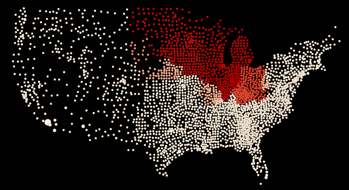
    On one side, the share of the population that is educated, states’ relative standings remain fairly similar to the way they were in 1970. Colorado, California, Connecticut, New Hampshire, New Jersey, Maryland and Virginia are all still above the national average for the percentage of the population over 25 with a bachelor’s degree, which has risen from 10.7% in 1970 to 29.6% in 2013. Massachusetts leads the nation with a remarkable 40.3% of its adult population having graduated from a four-year college. Overall, the “brainiest states” remain well ahead of their competitors in percentage terms.

    But in terms of growth in the raw numbers of educated people, most of these states have lagged. Indeed their high concentrations of college graduates may reflect their slow population growth, or the lack of opportunities for people without a bachelor’s degree.

    Educating The Sun Belt

    The states whose populations of college grads have grown the most are almost all in the South and the Sun Belt, led by Nevada with a 1,292% increase from 1970 to 2012 in the number of residents with four years of college or more, followed by Arizona (861%), Florida (743%) and Georgia (699%).

    Although they mostly still lag the best educated states, their large additions of educated workers appears to be transforming these former backwaters into centers of advanced industry and commerce. Since 1970, Texas has increased its population of college graduates by 555% while North Carolina’s surged 659%; in contrast, New York’s educated workforce expanded by 247% and Massachusetts’ by 341%, lagging the national average of 397% growth. California, whose economy grew rapidly through this period, was a shade above that with a 402% expansion in its population of college grads.

    The dichotomy is also pronounced when looking at the growth in the population of those with three years of college or more, including community college and certificate programs. Since 1970, for example, South Carolina expanded its population of such people by 746% and Texas by 592%; in contrast Massachusetts’ ranks of “some college” grew by 213% and California’s by 304%. Much of the growth among the leading states was tied to rapid overall population growth due to in-migration, particularly in states like Arizona and Nevada, which was accompanied by relatively rapid job growth.

    Brain Centers And Slower Growth

    The most educated states by percentage of college graduates are on the East Coast — Massachusetts, Connecticut, Maryland, Virginia, New Jersey — with the exception of Colorado. Many of these states also boasted among of the highest concentrations of college grads in 1970 (Colorado ranked first then with a 14.9% concentration). But with the exception of Virginia, since then the growth in the raw number of educated workers in these states has come at a slower rate than the Sun Belt states, amid their rapid population expansion. For example, since 1970 Connecticut’s population of college grads grew 282%, the fourth lowest rate in the nation and roughly half that of Texas’.

    Some might think that states with a higher proportion of educated workers would do better at creating new jobs. But since 1991, according to the Bureau of Labor Statistics, employment in both Massachusetts and New York has grown at 0.4% annual rate, and 0.8% in California. In contrast, Arizona’s annual job growth averaged 2.4% and Texas 2%.

    This suggests that having a high percentage of educated people is not enough to grow a jobs-rich economy, particularly if, as Robert Reich suggests, the demand for educated workers in the U.S. has dropped since 2000. It might seem tautological, but expanding economies  attract new educated workers.

    The Changing Face Of Poverty

    In 1959, the South was the poorest region in the country, with a poverty rate of 35.6%. By 1979, in the wake of the federal War on Poverty and strong economic growth, the poverty rate in the South had fallen by more than half, to 15.3%; by then, New York and Texas had roughly comparable poverty rates. (Note that I am not suggesting a linkage to the education trends discussed above, which mostly cover a later period.)

    The shift in the geography of poverty was underlined a few years ago when the Census released a new estimation of how to track it, the Supplemental Poverty Measure. (It takes into account the cost of a broader range of necessities than the standard measure, which is limited to food. It factors in geographic differences in housing costs, adds noncash benefits like nutrition assistance and housing subsidies to families’ incomes and subtracts taxes, child support payments and out of pocket medical expenses). The SPM placed 2 million more Americans below the poverty line as of 2012 than the standard measure; it dropped the poverty rate for those living in rural areas and raised it for those in metro areas and heavily urbanized states like California and New York. For the years 2010-12, California’s poverty rate jumps from slightly above average by the standard measure (16.5%) to the highest in the nation under the SPM (23.8%), followed by the District of Columbia (22.7%). Longtime laggard Mississippi, which ranks second worst in the country under the standard measure at 20.7%, falls back to the national average of 16% under the SPM, better than New York at 18.1%.

    Long-term income growth statistics over the same timespan as our education data also tell an interesting story. U.S. per capita incomes have risen 77% in inflation adjusted dollars from 1970 to 2013, according to the U.S. Bureau of Economic Analysis. The leader has been North Dakota, with a 160.4% jump to $53,182. Much of it seems tied to the energy boom – incomes have jumped 51% alone since 2000 — but it’s more than that. Its neighbor South Dakota, where oil production is much less important, ranks third in per capita growth over that span at 125.9%, as it built up a powerhouse financial services industry by loosening regulations

    Many of the regions where growth exceeded the national average have historically had low incomes. The former Confederacy accounts for eight of the top 20: Louisiana, Arkansas, Mississippi, Tennessee, Alabama, Virginia, Texas and North Carolina. (All still lag the national average income of $44,765, though, with the exception of Virginia). The Plains and Intermountain states account for another six (North Dakota, South Dakota, Wyoming, Minnesota, Oklahoma). The other big regional winner has been New England, with five of the top 20: New Hampshire, Vermont, Connecticut, Massachussetts and Maine. Washington, D.C., ranks 2nd, with growth of 129.4% to a nation-leading $75,329, showing us once again that our rulers treat themselves well.

    Among the laggards is California, where per capita income grew 62.4%, well below the national average. Several other Sun Belt “boom states” that rank highly on our list of states that have expanded their educated populations the fastest have done poorly in terms of income growth, including, Florida (41st), Arizona (48th), and in last place, Nevada. One complicating factor is that these states have a large proportion of people who earned their income in other, colder parts of the country. Not surprisingly, several of the laggards are in the Rust Belt, including Indiana (40th), Ohio (42nd), and Michigan (47th).

    The Future

    Clearly the economic and educational map of America is changing. There’s a movement of educated people — critical to many industries — to formerly backwater states. Over time jobs, too, are following this path.

    In the years ahead we can expect these trends to continue, or even accelerate. There is little reason to believe that states like California or New York are going to re-industrialize or reform their planning systems to help reduce housing prices. They will remain increasingly bifurcated between a very well-educated, affluent population clustered around the most elite industries and an underclass of poor, undereducated people. California, for example, ranks 14th in percentage of college graduates, down from 7th in 1970 but in terms of high school non-graduates it has soared from 44th to 2nd.

    This bifurcation doesn’t bode well for these places. People will continue to move to those places where young educated people are now going, notably in the South, the Great Plains, the Intermountain West, and, to some extent, parts of the Pacific Northwest.

    Forty years from now America will have many more centers of educational and economic excellence spread across the continent. This may involve a decline in the relative power of some regions, notably California, the Rust Belt and the Middle Atlantic States, but the rise of educated workers and employment elsewhere could help the country retain its competitiveness on an increasingly continental scale.

    The Biggest Brain Gain States Since 1970

    No. 1: Nevada

    Increase In Population Of College Grads, 1970-2013: 1,292%
    Pct. Of Adult Population With College Degree, 1970: 10.8%
    Pct. Of Adult Population With College Degree, 2013: 22.5%

    No. 2: Arizona

    Increase In Population Of College Grads: 861% 
    Pct. Of Population With College Degree, 1970: 12.6% 
    Pct. Of Population With College Degree, 2013: 27.4%

    No. 3: Florida

    Increase In Population Of College Grads: 743% 
    Pct. Of Population With College Degree, 1970: 10.3% 
    Pct. Of Population With College Degree, 2013: 27.2%

    No. 4: Georgia

    Increase In Population Of College Grads: 699%
    Pct. Of Population With College Degree, 1970: 9.2%
    Pct. Of Population With College Degree, 2013: 28.3%

    No. 5: North Carolina

    Increase In Population Of College Grads: 659% 
    Pct. Of Population With College Degree, 1970: 8.5% 
    Pct. Of Population With College Degree, 2013: 28.4%

    No. 6: Colorado

    Increase In Population Of College Grads: 617% 
    Pct. Of Population With College Degree, 1970: 14.9% 
    Pct. Of Population With College Degree, 2013: 37.8%

    No. 7: New Hampshire

    Increase In Population Of College Grads: 603% 
    Pct. Of Population With College Degree, 1970: 10.9% 
    Pct. Of Population With College Degree, 2013: 34.6%

    No. 8: Utah

    Increase In Population Of College Grads: 585% 
    Pct. Of Population With College Degree, 1970: 31.3% 
    Pct. Of Population With College Degree, 2013: 14.0%

    No. 9: Idaho

    Increase In Population Of College Grads: 563% 
    Pct. Of Population With College Degree, 1970: 10.0% 
    Pct. Of Population With College Degree, 2013: 26.2%

    No. 10: South Carolina

    Increase In Population Of College Grads: 556% 
    Pct. Of Population With College Degree, 1970: 9.0%
    Pct. Of Population With College Degree, 2013: 26.1%

    No. 11: Texas

    Increase In Population Of College Grads: 555% 
    Pct. Of Population With College Degree, 1970: 10.9%
    Pct. Of Population With College Degree, 2013: 27.5%

    No. 12: Alaska

    Increase In Population Of College Grads: 544% 
    Pct. Of Population With College Degree, 1970: 14.1%
    Pct. Of Population With College Degree, 2013: 28.0%

    No. 13: Virgina

    Increase In Population Of College Grads: 517% 
    Pct. Of Population With College Degree, 1970: 12.3%
    Pct. Of Population With College Degree, 2013: 36.1%

    No. 14: Washington

    Increase In Population Of College Grads: 513% 
    Pct. Of Population With College Degree, 1970: 12.7%
    Pct. Of Population With College Degree, 2013: 32.7%

    No. 15: Tennessee

    Increase In Population Of College Grads: 495%
    Pct. Of Population With College Degree, 1970: 7.9%
    Pct. Of Population With College Degree, 2013: 24.8%

    Joel Kotkin is executive editor of NewGeography.com and Roger Hobbs Distinguished Fellow in Urban Studies at Chapman University, and a member of the editorial board of the Orange County Register. He is also executive director of the Houston-based Center for Opportunity Urbanism. His newest book, The New Class Conflict is now available at Amazon and Telos Press. He is also author of The City: A Global History and The Next Hundred Million: America in 2050.  He lives in Los Angeles, CA.

    Photo: 1980s-era Reno, Nevada. Public domain.

  • Towns With a Past, Towns With a Future

    Over the last fifty or sixty years most towns have been dedicated to accommodated cars in order to cultivate business and permit people to live better more convenient lives. For new developments out in a former corn field this was effortless since everything was custom built with the automobile in mind. But older towns that had been built prior to mass motoring were at a distinct disadvantage.

      Screen Shot 2014-12-04 at 12.57.53 AM Screen Shot 2014-12-05 at 1.15.13 AM Screen Shot 2014-12-05 at 1.16.43 AM

    In order to keep up with changing times older neighborhoods, particularly older Main Street business districts, did whatever possible to retrofit themselves. The roads were widened, sidewalks were narrowed, street trees were removed, obsolete buildings were torn down to make way for parking lots, new zoning regulations and building codes were introduced to ease traffic and ensure abundant free parking. Unfortunately for many historic towns there simply was no contest. New strip malls and office parks could provide endless free parking and massively wide roads. If you add in the competition from big box national chains and the politics of race and class driving people across municipal borders for lower taxes and segregated school districts… Main Street never had a chance. The irony is that the more towns tried to accommodate cars the less pleasant they became.

    Screen Shot 2014-12-03 at 10.31.41 PM Screen Shot 2014-12-03 at 7.00.56 PM Screen Shot 2014-12-05 at 1.06.03 AM
    Screen Shot 2014-12-03 at 10.33.08 PM Screen Shot 2014-12-05 at 12.31.52 AM
    Screen Shot 2014-12-05 at 12.32.11 AM
    Screen Shot 2014-12-03 at 11.14.20 PM Google Earth

    This is a Google Earth image of the area around Cheviot, Ohio. The people of Cheviot self-identify with the fictional 1950’s TV town of Mayberry made famous by The Andy Griffith Show. It really is a lovely place, but it effectively has no business district anymore thanks to the Western Hills Plaza Shopping Center half a mile away which straddles Green Township and the Westwood district of suburban Cincinnati. Harrison Avenue, Cheviot’s century old Main Street, is circled at top right. Western Hills Plaza is circled at bottom left. The Home Depot, Target, Kroger, and Dillard’s make it impossible for mom and pop shops on Harrison Avenue in Cheviot to sustain themselves. Half the shops are empty and the others limp along. It’s a shame, because Cheviot is a charming town full of great old commercial buildings and solid housing stock. It’s a good town full of good people. The German Catholics who settled and built this part of Ohio have managed to hold on to a fair-to-middling set of arrangements through the worst years of decline, but the town is a shadow of its former self. It has excellent bones, but the flesh is sagging through no fault of its own.

    Screen Shot 2014-12-03 at 11.22.36 PM Screen Shot 2014-12-03 at 6.47.29 PM IMG_9387 (800x600) Screen Shot 2014-12-05 at 1.12.50 AM

    However, Cheviot has one thing that Western Hills Plaza doesn’t – a walkable, bikable, fine-grained pleasant neighborhood. That may not sound like much, but it’s more than nearly anyplace built after 1950 anywhere in North America can boast. Cheviot is an actual town, not just mindless suburban sprawl. That’s a rare commodity these days and a lot of people are hungry for it. Just about every home in Cheviot is within a five or ten minute walk of the old business district, local public schools, library, churches, and parks. It has become unusual in America for people to live in this kind of environment and it’s coming back in fashion with increasing demand and limited supply. There’s an opportunity here for people with the right attitude.

    Screen Shot 2014-12-04 at 1.09.07 AM Screen Shot 2014-12-04 at 1.08.19 AMGoogle Earth

    In contrast let’s say that you lived here on this cul-de-sac in Green Township and you wanted to go to one of the fast food places directly behind your back fence. This is the route you’d need to take.

    Screen Shot 2014-12-04 at 1.10.14 AM Google Earth

    If you’re used to driving everywhere everyday you might not think twice about hopping in the car. In fact, you might not even realize that the Burger King and KFC are so close. But if you were somehow forced to walk one day you might be surprised at how hard it would be given all the walls, fences, and drainage ditches that stand between you and your fast food. And the walk would be a miserable and potentially dangerous experience. The highway and its cavalcade of concrete and plastic bunkers is so wretched when you aren’t in a car that developers and city planners go out of their way to keep homes as isolated and buffered as possible. This radical separation of uses makes perfect sense in a car-oriented environment. Who wants to look out at a highway strip mall from the back yard? But it’s Hell on foot. And don’t even think of riding a bike. You’ll either get hit by a speeding car or attract the attention of the local police who will immediately identify you as a deviant. Being a pedestrian or cyclist in this environment constitutes “probable cause”. You must be unsavory if you lower yourself to such desperation here. Sitting at a bus stop in this setting is no joy either.

    Screen Shot 2014-12-04 at 12.51.28 AM Screen Shot 2014-12-04 at 12.53.48 AM Screen Shot 2014-12-04 at 12.23.18 AM Screen Shot 2014-12-04 at 12.55.51 AM IMG_9626 Screen Shot 2014-12-05 at 1.14.48 AM

    So here’s the challenge of the next few decades. The aging sprawl in Green Township and similar nearby post war suburbs like White Oak, Sharonville, and Deer Park on the edge of Cincinnati aren’t aging well. Their roads and sewer systems are right at the point where they need complete overhauls and there’s no money for any of it. Don’t expect Columbus or Washington to send big checks because they’re broke too. The housing stock in these places is neither charming in a Norman Rockwell sort of way, nor sufficiently Mad Men modern. Their roofs, windows, kitchens, baths and furnaces all need replacing right about now and there isn’t a lick of insulation in most of them. Fifty years ago these suburbs were white middle class havens with their backs to inner city decay and race riots.

    IMG_6149 (800x533) IMG_6126 (800x533) IMG_6164 (800x533) IMG_6155 (800x533) IMG_6128 (800x533)

    Now newer more prosperous suburbs Like Mason and Beavercreek farther out attract wealthier residents looking for larger homes with all the latest bells and whistles along with premium public schools and lower taxes. Green Township has less than half the average family income of Mason. Homes in Green Township and other similar areas sell for $75,000 although many homes can be found for considerably less. Mason homes sell for north of $250,000 with many at much higher price points. Meanwhile downtown Cincinnati and Over-the-Rhine are rapidly gentrifying as people who prefer an urban environment reinvigorate long abandoned neighborhoods. The poor are being displaced in the process and they’re going to have to live somewhere. Given the trajectory of these shifts it isn’t looking good for the so-so suburbs in the middle distance. We can expect more “Fergusons” on the horizon although the particulars are unknowable at this time. This economically induced migration won’t be good for the poor either. They just spent the last few generations sucking up the desiccated crumbs of 19th Century industrialism and now they’re being shunted off to the stale left overs of 20th Century sprawl just in time for it to die.

    Screen Shot 2014-12-05 at 1.06.38 AM Screen Shot 2014-12-05 at 1.07.09 AM Screen Shot 2014-12-05 at 1.13.14 AM Screen Shot 2014-12-05 at 1.08.55 AM  IMG_9203 (800x600) IMG_9191 (800x600) IMG_9197 (1024x768) (800x600) Screen Shot 2014-12-05 at 1.14.02 AM Screen Shot 2014-12-05 at 1.11.41 AM Screen Shot 2014-12-05 at 1.05.23 AM Screen Shot 2014-12-05 at 1.09.52 AM Screen Shot 2014-12-05 at 1.11.59 AM Screen Shot 2014-12-05 at 1.11.18 AM

    But there’s hope for some of these places. Pressed up against both Cheviot and Green Township is Westwood, a former streetcar suburb that also uses Harrison Avenue (the old streetcar route) as its long-lost Main Street. Westwood was once an independent town, but was annexed by Cincinnati a hundred years ago. It fell out of favor beginning in the 1950’s when the streetcar was ripped up and shiny new subdivisions and shopping centers were built-in places like Green Township. Moving children out of Cincinnati public schools to another jurisdiction a mile away was one of the primary motivations as racial tensions in the city grew. Taxes were also lower in the new suburbs. (Is any of this ringing a bell?) Cincinnati has recently figured out that it can’t compete with Mason or Beavercreek for that particular share of the upscale suburban real estate market, but it’s looking at the success of Over-the-Rhine and wondering what the family friendly conservative Republican Catholic version of revitalization might look like in Westwood. In other words, what can parts of Cincinnati provide in the way of a value-added “product” or “experience” in their century old neighborhoods of single family homes that Mason can’t. There’s a chance that Westwood’s competitive advantage might just be walkability and historic charm. The city adopted a form based code for this part of Westwood and has been investing money in the schools and parks with plans to create a town square in what is now an awkward triangular intersection next to the Carnegie library. There are also existing businesses and subtle interdependent institutions that simply don’t exist out in new suburban locations. If you want your cello or violin repaired you’re not going to find that sort of thing at the mall between the food court and the Sunglass Hut. A more pedestrian oriented Westwood with unique family oriented destinations and activities could be an engine that pulls the area in a better direction. Sooner or later all those Hipsters downtown are going to start getting married and having kids and their going to want a house with a patch of garden. There could be an advantage to having that life three miles from downtown instead of twenty-two miles out in Mason. On the other hand, Westwood could simply languish and be dragged down by the failing sprawl that surrounds it. It could go either way. Time will tell.

    John Sanphillippo lives in San Francisco and blogs about urbanism, adaptation, and resilience at granolashotgun.com. He’s a member of the Congress for New Urbanism, films videos for faircompanies.com, and is a regular contributor to Strongtowns.org. He earns his living by buying, renovating, and renting undervalued properties in places that have good long term prospects. He is a graduate of Rutgers University.