Tag: Transportation

  • Urbanists Need to Face the Full Implications of Peak Car

    As traffic levels decline nationally in defiance of the usual state DOT forecasts projecting major increases, a number of commentators have claimed that we’ve reached “peak car” – the point at which the seemingly inexorable rise in vehicle miles traveled in America finally comes to an end.   But while this has been celebrated, with some justification in the urbanist world as vitiating plans for more roads, the implications for public policy haven’t been fully faced up to.

    Indeed, the “peak car” is antithetical to the reigning urbanist paradigm of highways known as “induced demand.”  Induced demand is Say’s Law for roads: supply of lanes creates its own demand by drivers to fill them. Hence building more roads to reduce congestion is pointless. But if we’ve really reached peak car, maybe we really can build our way out of congestion after all.

    Traffic levels have stabilized or even fallen in recent years. According to analysis by economist Doug Short featured in Streetsblog, aggregate auto travel peaked on a per capita basis in 2005 and has fallen since. Per capita traffic levels are now back to 1994 levels, a two decade rollback in traffic increases.


    Population adjusted traffic growth. Image via Doug Short
    Even looking at total, not per capita travel shows a marked reversal.  The State Smart Transportation Initiative, a pro-environmental research center, put together a graph showing how high the US DOT’s traffic projections have turned out to be:

    VMT forecasts vs. actual. Source: SSTI

    This data is complemented by a slew of recent stories about the poor financial performance of toll roads, resulting in part from traffic falling far below projections.  For example, the concessionaire operating the Indiana Toll Road recently went bankrupt. Streetsblog reported that while projections forecasted traffic level increase of 22% in the first seven years, traffic actually fell 11% in the first eight.

    Recent traffic declines are a reversal of a long running trend of Vehicle Miles Traveled (VMT) increases at above growth in population. Some of this is no doubt due to the poor macro-economy. But there are reasons to believe we may be in a new era of traffic growth or lack thereof.  Many of the trends that drove high growth have largely been played out: household size declines, suburbanization, the entry of women into the workforce, one car per driver, etc. That’s not to say these will necessarily reverse. But we’ve reached the point of diminishing returns in terms of how many more women, for example, will join the labor force given that there’s already 57% female participation and their labor force participation rate is projected to decline in the future.

    This is potentially very good fiscal news, especially given tight budgets. Clearly many of the freeway expansion projects on the books that have been driven by speculative demand should be revisited.  For example, the state of Wisconsin has massive investments planned in Milwaukee area freeway system even though the metro area is very slow growth in population.  Are these really necessary?  Projects in more rapidly growing boomtown regions in places like Dallas, Houston or Charlotte may well continue to make sense. From top to bottom, engineers need to recalibrate their forecasting models to better correspond to reality. And to revisit highway plans accordingly.

    So the idea that we need to build fewer roads than we thought is sound. But less attention has been paid to the flip side implications of this.  To repeat, the induced demand theory says that there is a more or less infinite supply of traffic, thus any new roadway capacity will be used up shortly, leaving congestion as bad as the status quo ante.  Despite peak car, articles touting induced demand as a reason not to build roads continue unabated, including recent ones in Wired (“What’s Up With That: Building Bigger Roads Actually Makes Traffic Worse”) and Vox (“The ‘fundamental rule’ of traffic: building new roads just makes people drive more”).  In a world of peak car, where traffic levels are flat to declining on a per capita basis, induced demand no longer holds court, certainly not to the level claimed by those who believe it’s pointless to build roads.

    In fact, what peak car means is that while speculative projects may be dubious, there many be good reasons now to build projects designed to alleviate already exiting congestion.  Places like Los Angeles remain chronically congested, which has great economic and social consequences, not the least of which is the value of untold hours lost sitting in traffic.  While individual projects there might indeed be boondoggles, maybe it’s worth building some of the planned freeway expansions there in light of peak car. In short, in some cases peak car strengthens the argument for building or expanding roads.

    On the other hands, many of the regional development plans designed to promote compact central city development and transit may be predicated on an analysis that assumes large future traffic increases in a “business as usual” scenario.  Not just highways but all aspects of regional planning are dependent on traffic forecasts.  That’s not to say that such plans are necessarily wrong, but clearly revised traffic reality needs to be reflected in all plans, not just highway building ones.

    It’s not clear how this will all play out, but urbanists and policy makers of all stripes need to think about the full implications of peak car. At a minimum, the traditional “you can’t build your way out of congestion” rhetoric should be  supplanted, at least in most areas, by a more nuanced approach that neither overestimates demand, nor ignores the problems caused by rapid growth in some regions and pockets of congestion in others.

    Aaron M. Renn is an independent writer on urban affairs and the founder of Telestrian, a data analysis and mapping tool. He writes at The Urbanophile.

  • Los Angeles: Rail for Others

    A few years ago, the satirical publication, The Onion ran an article under the headline "98 Percent of US Commuters Favor Public Transit for Others." The spoof cited a mythical press release by the American Public Transit Association (APTA), in which Lance Holland of Anaheim, California said "Expanding mass transit isn’t just a good idea, it’s a necessity," Holland said. "My drive to work is unbelievable. I spend more than two hours stuck in 12 lanes of traffic. It’s about time somebody did something to get some of these other cars off the road." The Onion spoof said that APTA would be kicking off a new promotional campaign using the slogan "Take the Bus… I’ll be Glad You Did." The Onion spoof singled out Los Angeles County Metropolitan Transportation Authority (MTA) officials as saying that public support for mass transit will lead to its expansion and improvement."

    "Transit for Others" characterizes three decades of transit in Los Angeles County. Despite its massive $10 billion plus rail program, MTA bus and rail services carried fewer riders in 2012 (latest Federal Transit Administration data) than were carried by the buses in 1985 (MTA was formed in the early 1990s from a merger between the Los Angeles County Transportation Commission and the Southern California Rapid Transit District).

    The Birth of Modern Rail

    The history of the modern Los Angeles rail revival began with a special meeting of the Los Angeles County Transportation Commission on August 20, 1980. I was to play a principal role.

    I had the honor of being appointed to LACTC by Mayor Tom Bradley to three terms and was the only principal commissioner who was not an elected official. The other members, under state law, were the Mayor of Los Angeles, a Los Angeles City Council Member, the Mayor of Long Beach, two city council members from other cities, the five county supervisors and an additional member appointed by the Mayor of Los Angeles (which was me).

    The special meeting had been requested by legendary county Supervisor Kenneth Hahn, who proposed a 5-year reduction of the bus fare to $0.50 to be financed by a sales tax increase, which would be submitted to the voters at the November election. Any money not needed for the bus fare reduction would be used for unspecified transit  purposes.

    The original motion by Supervisor Hahn was amended by Gardena Mayor Edmund Russ, who proposed a "local return program," which would dedicate 25 percent of the funding to municipalities (and Los Angeles County for unincorporated areas) on a population basis, to be used for transit services. At that time, local operators provided less than 20% of the bus service, with the overwhelming majority of services provided by the Southern California Rapid Transit District (SCRTD). 

    I was concerned that the proposal by Supervisor Hahn failed to provide funding for a rail system. I believed at the time that a rail system would reduce the intractable traffic congestion in Los Angeles. I was also concerned at the rapidly rising unit costs of bus operations and was convinced that unless there was a "firewall," no money would be available for rail.

    As a result, on the spur of the moment, I introduced an amendment to direct 35 percent of the proceeds to rail. This motion was seconded by Supervisor Baxter Ward and was incorporated into the final package Supervisor Hahn accepted a shortening of the reduced fare period to three years. The measure, Proposition A was placed on the ballot and was passed by the voters in November.

    Transit Since Proposition A

    The impacts of the three programs approved in 1980 had varying results on transit in Los Angeles.

    Three Year Fare Reduction (1982-1985): Between 1982 and 1985, there was a flat $0.50 fare for transit services in the county. SCRTD experienced an increase from 354 million to 497 million annual passengers. At 40%, this may be the largest three year relative increase in any large transit agency’s ridership in decades. Ridership fell after subsequent fare increases.

    Further, the fare reduction was cost effective. The cost per new rider was less than $1.00 (2012$), a small fraction of typical projected costs per new riders on proposed rail transit systems around the country. By comparison, the cost per new rider on the east extension of the Gold light rail line was projected at more than $30 (2012$, $24.19 in 2003). This is more than 30 times the cost per new rider of the low fare program.

    The strong ridership increase in response to the low fare program is consistent with the relatively low incomes of Los Angeles transit commuters. In 2013, the median income of Los Angeles County transit commuters was approximately one-half that of the national, 60 percent below that of the six metropolitan areas with transit legacy cities (New York, Chicago, Philadelphia, San Francisco, Boston and Washington) and even lower than the other 45 metropolitan areas over 1,000,000 population (Figure 1)

    Local Return Program: Since 1985, when the bus fare reduction program ended, by far the greatest impact on ridership was from the Local Return program. In 1985, the existing local bus operators carried approximately 55 million annual passengers, a figure that rose to more than 130 million in 2012 (a nearly 140 percent increase). This ridership increase is more passengers that were carried on all the bus and rail systems of Dallas (DART), Salt Lake City and St. Louis in 2012, according to Federal Transit Administration data.

    Urban Rail Program: Many miles of urban rail have been built in Los Angeles County, including two subways and five light rail lines (determined by route termini from downtown). But the hope that others would leave their cars for transit, as expressed in The Onion has not occurred. By 2012, Federal Transit Administration data indicates that MTA (formed by a merger of LACTC and the Southern California Rapid Transit District, which operated the system before) bus and rail system was carrying 475 million annual riders, down from the 497 million carried on buses alone in 1985.

    This is despite constructing billions  in subway lines, light rail lines, and rapid busways and the addition of approximately 2 million residents to Los Angeles County.

    The "Return" on Local Return: The big surprise was the "return" on the local return program. A number of new systems were established, such as Foothill Transit and the Antelope Valley Transportation Authority. Many cities established new bus and paratransit systems. The city of Los Angeles now operates a number of commuter express bus services and local circulation bus services throughout the city. Many of the new systems used competitive tendering, under which services are awarded to competing private companies, with fares, routes, and schedules dictated by the public agencies. One important advantage of competitive tendering is lower costs, which makes it possible to provide more service. This service approach has been used extensively in Denver and San Diego. Further, virtually all of London’s largest public bus system in the high income world is competitively tendered as are  all of the bus, subway, commuter rail and light rail services in Stockholm.

    Overall, the Los Angeles County transit system, including MTA and the local operators experienced a ridership increase of 55 million between 1985 and 2012 (This excludes Metrolink, the five county commuter rail system established in the 1990s). Virtually all of the ridership increase is attributable to the local bus services operated by cities and by new sub-regional agencies (Figure 2).

    Overall Transit Work Trip Share

    Census Bureau data indicates that the employment access share of transit in Los Angeles County has declined modestly, from 7.0 percent in 1980 to 6.9 percent in 2013 (including Metrolink). Driving alone increased from 68.7 percent to 72.7 percent, while car pool commuting dropped from 16.8 percent to 10.0 percent. Outside of driving alone, the largest increase occurred in working at home rising from 1.5 percent to 5.2 percent (Figure 3). Unlike transit, working at home requires virtually no expenditures of public funds. Transit one-way work trips increased 77,000 daily, while driving along increased 947,000 and working at home increased 182,000. Car pools suffered a large loss (Figure 4).     

    Thus, despite rave reviews about its rail system, Los Angeles relies on cars to an even greater extent than before. Los Angeles qualifies as the next great transit city only if the standard is spending and construction, rather than ridership.

    Wendell Cox is principal of Demographia, an international public policy and demographics firm. He is co-author of the "Demographia International Housing Affordability Survey" and author of "Demographia World Urban Areas" and "War on the Dream: How Anti-Sprawl Policy Threatens the Quality of Life." He was appointed to three terms on the Los Angeles County Transportation Commission, where he served with the leading city and county leadership as the only non-elected member. He was appointed to the Amtrak Reform Council to fill the unexpired term of Governor Christine Todd Whitman and has served as a visiting professor at the Conservatoire National des Arts et Metiers, a national university in Paris.

    —-

    Note: Part of the MTA/SCRTD ridership loss was due to the transfer of services to Foothill Transit and the city of Los Angeles in the late 1980s.

    Photo: Los Angeles County Transportation Commission logo from 1980s

  • Real Economic Payoff from Infrastructure

    With the Obama proposal to get some money for infrastructure, it is time to revisit the payoff from investments in transportation. Investments that improve the performance of transportation in the US will pay for themselves in 17 years through increased economic activity and the resulting gains in federal tax revenue. The rate of return for national investments in transportation is 7%, significantly more than the cost of borrowing. Recently released research verbalizes a theory of why the performance of infrastructure matters for the economy.

    Transportation provides the foundation for all economic activity. Transportation is used to bring labor and inputs to places of production, to deliver final goods and services to end users and to bring customers to the market place. How well is it doing its job? In an economy the size of the US even small improvements can mean big dollar gains. Making the investment to improve transportation performance can result in a measurable return on investment with a payback period that is well short of the life-expectancy of most transportation infrastructure.

    Just as infrared is the invisible part of the spectrum of light, it often seems that infrastructure is the invisible part of the economy. It has become popular – especially since the turn of the century – to think of the economy as increasingly dependent on the insubstantial and the ethereal – emailing, e-trading, e-commerce. The reality is that all commerce – even e-commerce – eventually depends on transportation infrastructure. After all, someone has to get the computer components from the factory to the e-business; and when the computer hardware breaks down, someone will likely use transportation infrastructure to get to the place of business to fix it. No e-commerce can occur until transportation infrastructure is used to get the equipment to the location where rare earth minerals are extracted and to take those minerals to the factory – usually on another continent – where workers arrive via transportation infrastructure to build the computers in the first place. In many ways, there can be no commerce – “e“ or otherwise – without bricks-and-mortar infrastructure.

    Despite repeated outcries for additional funding, transportation spending in the US was more than $100 billion under budget in the first decade of the new century. While there is much debate about how much to spend on transportation, since 1980 (1990), federal spending on transportation in the US has been $152.3 billion ($125.5B) less than budgeted. Federal spending on transportation exceeded budget in only four years: 2011 by $6.5 billion (the most ever), 2012 by $4.4 billion, 1996 by about $3 billion, and 1995 by $50 million. The $10.9 billion spending over-budget in 2011 and 2012 was necessary to fulfill commitments from 2009, when spending was under-budget by an extraordinary $40.7 billion. Excluding 2009, the average annual under budget since 1980 (1990) was $3.5 billion ($3.8 billion).

    Figure 1 Federal Spending Over/Under-Budget 1980-2012

    Screen Shot 2014-05-21 at 2.20.23 PM

    Data Source: Budget of the United States, Transportation Budget Authority FY 2011, Table 3.1 Outlays by Superfunction and function, updated with Table 5.1 from FY2014 tables; actual spending through 2012. Red on either line indicates spending over budget for that year. Author’s calculations.

    Table 1 Federal Spending Under-Budget by Decade

    Screen Shot 2014-05-19 at 5.03.29 PM

    Worse yet, transportation policy has been allowed to stagnate: the strategic economic goals and performance measures in the Department of Transportation’s 2014 performance plan are nearly identical to the 2002 plan. Economic competitiveness is one of the strategic goals set by the US Department of Transportation (Performance Plan FY2014, available at www.dot.gov). By their definition, economic competitiveness means maximizing the economic returns of the network and keeping the transportation system responsive to consumer needs. This may sound like the kind of initiative that would allow the US to stay globally competitive. However, these strategic goals are little changed from ten years ago; and most of the performance measures in the 2014 economic strategy were the same in 2002. Each strategic goal is also associated with a line-item in the federal budget, making them more than just slogans, making them actual cost centers.

    Figure 2 Department of Transportation Performance Plans

    Screen Shot 2014-05-19 at 5.53.47 PM

    Clearly, what the US needs now is better planning and strategic project selection, plus streamlined delivery processes to increase the productivity of infrastructure investment. Most of the existing transportation infrastructure could not handle the coming surge in demand. The surge is not only the result of organic growth in the size of the country, but also from an increase in the fundamental reliance of our economy on the use of transportation infrastructure. The result will be a nation falling further and further behind our global competitors.Yet, the world that business moves in has changed significantly as has the way that business moves. The service sector – the fastest growing part of the economy – is increasingly dependent on transportation. The services sector has the second fastest growing usage of transportation services (after construction) and remains the fastest growing sector in the US economy. Measuring the economy’s response to a change in the demand for transportation services, DOT-RITA conclude that “an investment in … transportation will have a greater economic impact than an equally sized investment in trade or utilities.” Investments to improve air transportation services would have the biggest economic impact. Except for rail transportation, the impact of improving the nation’s airports is bigger than investments in government and information services.

    Table 2 World Economic Forum, Global Competitiveness Report 2009-2010


    *The European Union economy is the largest in the world (CIA, 2013).  Scores are the result of responses to questions in the format: “How would you assess the quality of  [X] in your country? (1 = extremely underdeveloped; 7 = extensive and efficient by international standards),” where [X] is “Basic Infrastructure”, “Roads”, Railroads”, etc.  Scores for 2009-2010, US rank for transportation infrastructure was little change in 2012-2013 (13th). Details available at http://www.weforum.org/

    What will it cost?

    The US has more airports, roads and railways than any other country in the world – only Russia, China and Brazil have more waterways. However, the US is not alone in needing massive investments in infrastructure.

    The total investment needed for all infrastructures worldwide is estimated at $53 trillion through 2030, with a total of $15.5 trillion just for transportation. The Organization for Economic Cooperation and Development and others estimate a cost equivalent to 3.5% of GDP to improve infrastructure across all sectors – water, energy and transportation. A report from McKinsey Global Institute (McKinsey Infrastructure Practice) calculates that this investment is 60% more than all spending in the last 18 years; and more than the estimated value of today’s worldwide infrastructure. Consulting firm Booz Allen projects the cumulative infrastructure spending needs for the US (and Canada) from 2005 to 2030 to be $936 billion for road and rail and $432 billion for airports and seaports (about $1.4 Trillion total). Dividing this between the US and Canada in proportion to real GDP, just over $1.2 trillion is needed to upgrade the performance of US transportation infrastructure to first class.

    For the purpose of demonstration, let’s assume that the entire $1.2 trillion is invested in the US in 2014. The latest models demonstrate that the economic gains would begin to appear as higher GDP per capita in 2018. The economy starts 2018 at a level that is higher than it would have been without the investment in infrastructure. By 2025, the economy is larger by an amount greater than the initial investment in 2014. In financial terms, the investment has a 17 year payback period – substantially shorter than the life expectancy of transportation infrastructure. Taking 25% of the gain each year as government revenue (average government tax revenue as a percent of GDP in the US), the cumulative increased tax revenue will exceed the cost by 2025. A standard, basic financial analysis well-understood by both business executives and policy-makers shows a 7% internal rate of return – a number significantly higher than the borrowing costs for financing transportation infrastructure investments in the United States.

    Paying For It

    But what about the rest of the story: where does the initial funding come from to make the needed performance improvements? There is no “free ride” here – the construction and renovation of transportation infrastructure carries a hefty price tag that has to be paid one way or another. The options currently under discussion among researchers and policy makers in the United States are:

    1. The status quo – which has not worked in over 20 years.

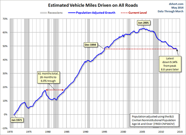
    2. Reducing demand – One way to improve performance is to discourage the use of transportation infrastructure. Joel Kotkin reports the work of demographer Wendell Cox on the new migration to America’s “Efficient Cities” – resulting in net outmigration from America’s most congested cities.  Smaller populations are one way that the demands on infrastructure may fall naturally – but with potentially undesirable consequences for economic growth. While American’s do more driving than any other nation on earth, there is some new evidence that the long standing trend of increasing driving is tailing off.

    3. Increasing user fees — Unfortunately, user fees are wrought with difficulties. First, “congestion pricing” fees are used to reduce demand rather than as a way to generate a revenue stream (with the obvious exception of some toll roads). There are several specific challenges: federal barriers to implementing fees and transaction costs are the most obvious. While the impact of fees as a revenue mechanism may be modest, there are additional implications for land use patterns and policies. Urban Land Institute provides an important cautionary note on tolling that could be applied to user fees in general. If the fees are permanent and not limited to rewarding investors in a particular facility, local policies will need to be established regarding the distribution of income beyond the designated payback period. The alternative, of course, is to tie the period of the fees to the reward and repayment of investors.

    4. Public-Private Partnerships — Also known as PPP or P3 – cover a spectrum of financing options ranging from private concession operators to privately owned roads. At the lowest level on the PPP spectrum are private operators who raise their own financing for upfront costs and ongoing operations for concessions such as food service on highway plazas or newspaper stands inside train stations. Their revenue generally comes from sales. At a higher level, risk is allocated between public and private partners (e.g., public carries demand risk, private carries construction risk). Financing is often shared and comes in the form of both equity and debt. The revenue stream to repay debt (or reward equity investors) comes from user fees. In “build, operate, transfer” (BOT) cases, the government’s role changes from manager, operator and financier to regulator. Effective government controls on safety and security, anti-competitive behavior (access, pricing, service quality, etc.) are critical to the success of these projects. The final level is a purely private project which is used for public purposes. The private owner/operator builds the facility. A revenue stream is necessary to service debt, repay financial loans/borrowings, and reward capital investment. Freight railroads in the US are a good example of privately financed infrastructure in the US.

    There is no lack of private money – especially under the current conditions of Federal Reserve intervention in the economy. According to a 2013 study by consulting firm McKinsey, an additional $2.5 trillion will be made available for infrastructure financing by 2030 if institutional investors meet their target allocations. The trouble is finding ways to direct revenue back to the private investors.

    Other Revenue StreamsUntitled

    How do we create that revenue stream to attract private investment into public infrastructure? Americans are notoriously opposed to paying for public goods. Branded revenue opportunities are just coming on the table in the US but have been used wide and far in other countries.

    Branded revenue streams – or private advertising in public spaces – has come a long way since realtors put their faces on benches or lawyers put their names on the backs of city buses. Branding now extends to the infrastructure itself. New York City’s Metropolitan Transit Authority added branding to turnstiles and train doors. More opportunities exist, including entrances, escalators, stairs, trains, overpasses, poles, walls, and even floors. Phoenix and Denver expect to earn up to $1 million in annual revenue from wrapping light rail trains in advertisements.

     Branding is not limited to print, either. New York, Chicago and Santa Monica are exploring LED advertising on the sides of busses. Dayton, Champaign-Urbana, Toledo (TARTA) and Kansas City (KCATA) have audio ads timed to promote businesses along routes. Just as advertising in metro transit is no longer limited to framed posters on subway platforms, highway advertising is no longer just for billboards. Why not, as pictured here, allow branding on overpasses? In November 2010 (USA Today November 22), cash-strapped California considered generating a much-needed revenue stream by allowing advertisements on emergency (“Amber-alert”) highway signs. But even these signs are virtual antiques. Ideas for where and what can accommodate an attractive yet discrete opportunity for a branded revenue stream are only limited by the number of pixels that can be used in an electronic display.

    The Way Forward

    All is not doom and gloom. There is a new, improving trend in the performance of transportation infrastructure in the United States. These improvements are a reflection of broad-based initiatives on both the supply and the demand sides. Meanwhile, the US continues to decline in the global rankings for poor transportation infrastructure (World Economic Forum, Global Competitiveness Index, shown earlier). Although US road, rail and even port rankings manage to stay in or near the top 20 in the world in the rankings, the US airport infrastructure quality ranking fell from 9th in the world in 2007-2008 to 32nd in 2010-2011 (currently at 30th).

    The underlying question is not how much to invest it is how that investment can deliver improvements in infrastructure. Analysts at McKinsey estimate that streamlining infrastructure delivery alone could generate 15% in cost savings. Clearly, additional funding alone is not enough. We also need innovative ways to fund, build, maintain and operate the vital transportation structures that support economic activity.

    Acknowledgements: Some of this material was previously published as STP Working Paper 2014_02, Calculating the Real Economic Payoff of Infrastructure. The Let’s Rebuild America initiative at the US Chamber of Commerce is headed by Janet Kavinoky. Funding for the project was also provided by the National Chamber Foundation in Washington, D.C. The original project team for developing indices to measure the performance of infrastructure in the United States was led by Michael Gallis and Associates of Charlotte, NC. The author is grateful to Kamna Pandey in New Dehli (India) for her slide show on revenue streams.

    Susanne Trimbath, Ph.D. is CEO and Chief Economist of STP Advisory Services. Dr. Trimbath’s credits include appearances on national television and radio programs and the Emmy® Award nominated Bloomberg report Phantom Shares. She appears in four documentaries on the financial crisis, including Stock Shock: the Rise of Sirius XM and Collapse of Wall Street Ethicsand the newly released Wall Street Conspiracy. Dr. Trimbath was formerly Senior Research Economist at the Milken Institute. She served as Senior Advisor on United States Agency for International Development capital markets projects in Russia, Romania and Ukraine. Dr. Trimbath teaches graduate and undergraduate finance and economics.

    This piece was originally published by IO Sustainability.

  • Should the Gas Tax Go Local?

    After approving yet another general budget stopgap for highway construction in July, legislators across the country are acknowledging the obvious: The Federal Highway Trust Fund, the primary pot of federal roadway dollars, is nearly out of gas.

    The fund has been fed for decades by the federal taxes on gasoline and diesel fuel. But the gas tax hasn’t been raised in 21 years. At the same time, people are driving less, and using more fuel-efficient cars. As a result, federal fuel tax revenues have fallen to just 60 to 70 percent of gross federal highway expenditures.

    The resulting fiscal dilemma has kickstarted a debate among policymakers on how to get the fund solvent again. Simultaneously, it’s also attracted attention from many planners looking for an opportunity to stress what they perceive as the unsustainability of America’s suburban low-density development.

    The core of the argument by these critics is that current infrastructure funding policies do not hold drivers accountable for the costs of the roads. Nationally, gas taxes and vehicle fees cover just half of total local, state, and federal road spending. They contend that if roads had to be paid for directly by those who used them, we’d likely have denser development and fewer cars, and that planning policy should embrace an ambitious course to implement that future through centralized land use regulation and urban design.

    But this approach is neither desirable nor necessary. Instead, there are ways to restructure infrastructure funding to make roads accountably solvent without turning society upside down.

    A first step would be to reduce the enormous control the federal government has over road construction. When first created, the federal highway trust fund was designed to ensure only the maintenance of the national interstate highway network.

    But today, the fund, which accounts for a quarter of all American roadway spending, is used for numerous other projects that can’t be justified as national priorities. As of 2011 20 percent of federal highway spending went to federal priority DOT projects. The remaining 80 percent was divvied out to states and communities via grants, many of them for capital outlays for new roads at the suburban edges of expanding regions. Communities should be expected to pay for these kinds of roads themselves, especially as the number of local projects continues to grow.

    This federal spending has encouraged a lack of accountability at the local level. While it has given the federal government the freedom to address concerns about existing infrastructure projects — since 1990 Washington has reduced the share of bridges deemed “structurally deficient” from 25 percent to 11 percent – it has done little to ensure that local projects will be prioritized responsibly in the future. Instead, cities and states have accrued federal dollars primarily on the basis of marketing, regardless of whether the costs and benefits actually add up.

    Balancing those costs and benefits is a crucial issue because, in the eyes of many planners, auto-dependent suburbanites are getting a free ride while urbanites who drive less are being unfairly taxed. Meanwhile, there is no clear answer to the question of how much people would be willing to pay for infrastructure in order to live at low densities if they were shouldering the costs directly.

    Polling data does little to resolve the uncertainty. When asked, a majority say that they like their commutes, that they would rather drive than travel by other modes, and that they greatly value the positive attributes of living at low densities in detached homes with yards and privacy from their neighbors. This suggests they would be hard-pressed to relinquish the status quo. Simultaneously, however, they also overwhelmingly oppose raising the federal gas tax.

    So where do the public’s priorities really fall? This question could be better answered if more infrastructure were funded locally. Not only would it allow more accountability between those providing the funding and those accruing the costs and benefits, it would more democratically help solve the density issue by letting people vote with their feet. People would be free to choose between the wide-ranging densities and tax rates that compose the many competitive municipalities of most regions.

    There are other benefits to concentrating road spending locally. Foremost among them is that communities and states are better equipped than the federal government to tackle congestion, one of the costliest contributors to road degradation

    Since 1982, the primary federal approach to combat congestion costs through the gas tax has been to redirect an increasing portion of revenues to a Mass Transit Account under the principle of encouraging alternative modes of transportation. It hasn’t worked. Between 1978 and 1995 transit funding increased eightfold, while ridership increased just two percent. And by 2005 Americans indicated they still overwhelmingly rejected transit, even when both driving and transit were available.

    Much of the gas tax has been wasted. The American Public Transit Association reports that about 15 percent of the gas tax is used for mass transit. Roads carry just 51 percent of their own costs. Ports, airports, and parking facilities, by contrast, paid for 80 to 100 percent of their own costs when measured the same way.

    Cutting off the transit syphon would free up significant capital to patch gaps in the Highway Fund. Meanwhile, more effective approaches to reducing congestion could be tackled at the state and local level. These include regulations to stagger travel times and routes, clearing breakdowns more quickly, improving traffic light engineering, providing better traffic alerts, and limiting truck traffic (one of the worst congestion offenders) at certain times of day.

    Most of the public debate has been on ways the gas tax itself could be restructured to keep the highway fund afloat. In addition to simply raising the gas tax, universal tolling and taxing people per mile driven are popular ideas for directly funding roads.

    While popular, such “miles-based” approaches may not improve a roadway system that is a crucial tool for facilitating economic growth. Housing prices in the United States are lower than nearly anywhere else in the world in part because of roads that facilitate cost-efficient transportation between locations more efficiently than places where most residents are dependent on transit. This creates choice in where to live and work, and facilitates ladders out of poverty.

    There are practical concerns as well. When polled, people have overwhelmingly indicated that their primary personal method for alleviating congestion is to take a less direct route to work. Discouraging indirect travel by taxing drivers per mile could actually end up exacerbating congestion, rather than relieving it.

    The way the tax is designed now is a solid middle-ground approach, simultaneously charging users while incentivizing fuel-efficiency. If only the revenues were spent more efficiently, recent dips in Highway Fund revenues due to a drop in driving and an uptick in miles per gallon might be celebrated, not maligned.

    It’s clear that roadway funding needs a second look. And while a more accountable approach would be a breath of fresh air, accountability may not resemble the high-density, high-tax, transit-rich future that some planners assume.

    Roger Weber is a city planner specializing in global urban and industrial strategy, urban design, zoning, and real estate. He holds a Master’s degree from the Harvard Graduate School of Design. Research interests include fiscal policy, demographics, architecture, housing, and land use.

    Flickr photo by Neff Conner: Highway traffic jam and construction in Bedford, Texas.

  • California Bad to its Bones

    Any serious student of California knows that the state’s emergence in the past century reflected a triumph of engineering. From the water systems, the dredged harbors, the power stations and the freeway system, California overcame geographical limits of water, power and its often-unmanageable coastline to create a beacon of growth and opportunity.

    That was then, but certainly not the case today. Indeed, since the halcyon postwar days of infrastructure-building under Gov. Pat Brown, roughly one-in-five dollars of state spending went to building roads, bridges, water systems and the like. Today, this investment amounts to less than 5 percent.

    As a result, California, once the exemplar of modernity, has among the worst road conditions in the nation, a tenuous, but still extraordinarily expensive, energy grid, as well as an increasingly uncompetitive port structure. Thinking itself a youthful magnet for building entrepreneurs of all kinds – creators of new communities, manufacturing and logistics industries – California is increasingly viewed by other places, both in the country and abroad, as an ideal place to hunt for skilled people, expanding industries and investment capital.

    Why has this happened? To some extent, the shift away from infrastructure has a generational twist, reflected, for example, in the differences between Pat Brown and his son, Jerry, who, upon first taking office, in 1975, as recalled by a longtime adviser, Tom Quinn, expressed distaste for his father’s “build, build, build” thing.

    This reaction was not totally illogical. Anyone who has lived here for decades naturally recoils from some of the consequences wrought by large-scale construction upon formerly bucolic areas, turning some of them into unsightly, often dysfunctional, messes.

    Under any circumstances, Pat Brown-level infrastructure building is probably beyond the financial means of the state. At the same time, California’s modest population growth – in contrast with the huge increases of the Pat Brown era – means arguably less demand for new building projects.

    Right now, the only dynamic growth sector of the state economy – social media and software – relies far less on traditional infrastructure than do older industries. Unwilling to pay California’s high costs for energy, water and other things, these tech firms tend to place their industrial projects, as well as their computer servers, in lower-cost regions, often states that tend to be more pro-active in their infrastructure investments.

    Yet just because California can’t finance a second huge building program, there’s little question that new and effective investment in roads, pipelines, bridges and ports is desperately needed. Much of this work may be in retrofitting older infrastructure. The recent flooding on and around the UCLA campus from a broken Los Angeles city water main and frequent smaller water main breaks in Southern California are just one indicator that we no longer keep up even with very basic public needs. As the California League of Cities recently observed, the state’s “infrastructure is rapidly deteriorating. Quite simply, California is crumbling.”

    The League of Cities suggested the state needs to spend some $500 billion over 20 years to maintain its economic competitiveness. But right now there’s little reason to think the current administration and bureaucracy is capable of spending money wisely. The recently completed $6.5 billion eastern span of the San Francisco Bay Bridge, built largely of steel imported from China, is widely suspected of being poorly constructed, and, according to one engineering expert, may need repairs well before its time. There appears to have been systematic “disregard for welding procedure,” with cracks already appearing on the bridge.

    The fact that the state allowed such shoddy work, at taxpayer expense, should be a warning that other state projects might be facing similar issues. Indeed, one can already see, as professor and author Walter Russell Mead has suggested, a similar pattern of disappointment even in the initial phases of Gov. Jerry Brown’s high-speed rail project, with rising cost estimates as well as diminished projections of the train’s speed.

    Ultimately, this boils down to a question of priorities. A state that can’t correctly maintain its existing pipelines and bridges is probably not a good candidate for bold new infrastructure adventures. This is not merely a conservative view, but one held by many liberals. Lt. Gov. Gavin Newsom has suggested that the money poured into high-speed rail may be better spent on “other, more-pressing infrastructure needs.”

    Similar criticism has come from progressive journalist Kevin Drum of Mother Jones magazine,who called projections for the bullet train’s ridership and cost – now pegged at close to $100 billion, almost twice the original projection – “jaw-droppingly shameless,” an appropriate characterization based upon the method and documentation. He suggests that a “high school sophomore who turned in work like this would get an F.” Spending for Gov. Brown’s signature project grows exponentially, even as basic needs are ignored.

    This spending on the nice, as opposed to the necessary, extends down to the local level, where infrastructure already often comes in second to ever-expanding public worker pensions. Los Angeles Mayor Garcetti is totally committed to spending more on expensive mass transit and housing densification, which itself strains infrastructure built for much lower density.

    And, this priority persists even though we have particularly tepid population growth in Los Angeles and have seen very little increase the past 30 years in the percentage of people taking public transit to work. The insistence on building expensive light rail, instead of far-less-expensive bus-based systems, effectively chokes off funds for improving the day-to-day lives of most Angelenos.

    Although there’s little hope we can go back to the era of massive building during the Pat Brown years, we could certainly get a lot smarter about how we can rebuild the state and return to sustained, widespread growth. The water crisis, which has plagued the state repeatedly over generations, would have been less severe had we built more storage facilities during the wet years, notes economist Bill Watkins, and improved our ability to move water across the state. Yet, as Sacramento Bee columnist Dan Waltershas pointed out, the environmentalists who suggest California may experience long-term drought conditions due to climate change have also opposed such practical steps to cope with the problem.

    Much of this reflects the economic unreality of California politics. We neglect roads, bridges, ports and economic energy projects because, in many ways, these are not a priority of the green lobby, which prefers less growth, more density and a shift from cars to transit. So, instead, we get money spent on high-speed rail and ultracostly, environmentally damaging solar panel farms or inefficient wind turbines erected in the middle of the desert.

    These energy costs hit hardest the state’s interior and heavily Hispanic working class but this doesn’t seem to much bother the state political leaders, who come overwhelmingly from the affluent parts of the Bay Area and coastal Southern California.

    So in the name of trying to appear “visionary,” as Brown, Garcetti and their minions portray themselves, in the real world, our state falls ever further behind competitors, many of whom are rapidly improving their infrastructure – everything from roads and ports to parks.

    We collectively may no longer be the vibrant young adult of the Pat Brown years a half-century ago, but there’s no reason for us to enter advancing middle age with politically induced decrepitude. It’s a disservice to the people who endure high taxes and relentless regulation with little benefit to their day-to-day lives.

    This piece first appeared at the Orange County Register.

    Joel Kotkin is executive editor of NewGeography.com and Roger Hobbs Distinguished Fellow in Urban Studies at Chapman University, and a member of the editorial board of the Orange County Register. His newest book, The New Class Conflict is now available at Amazon and Telos Press. He is author of The City: A Global History and The Next Hundred Million: America in 2050. His most recent study, The Rise of Postfamilialism, has been widely discussed and distributed internationally. He lives in Los Angeles, CA.

    Photo by Thomas Pintaric (Own work) [GFDL or CC-BY-SA-3.0], via Wikimedia Commons

  • Taiwan High Speed Rail Near Bankruptcy

    Efforts are underway by the Taiwan government for a government led restructuring to avoid bankruptcy (Plan to stop Taiwan’s high-speed rail going bust set for review). Since opening in 2007, this privately financed and operated system has been plagued with ridership well below projections. The Taiwan experience is consistent with the research showing that ridership on high-speed rail lines has been frequently over-projected.

    Minister of Transportation and Communications (MOTC) Yeh Kuang-shih offered this sobering assessment:

    “This is not the best time to address the financial problems, but it is the last window of opportunity. The Taiwan High Speed Rail Corp will definitely go bankrupt if the problems are not addressed by the end of the year. The only other solution would be a government takeover. If the company files for bankruptcy and the government is forced to take over operation of the system, the banks will probably collect on their loans, but neither large nor small investors will get anything back.”

    Kuomintang Party legislator Lin Kuo-cheng said that the "debt" and "accumulated losses" mean that the Taiwan high speed rail line is "broke."

  • New Commuting Data Shows Gain by Individual Modes

    The newly released American Community Survey data for 2013 indicates little change in commuting patterns since 2010, a result that is to be expected in a period as short as three years. Among the 52 major metropolitan areas (over 1 million population), driving alone increased to 73.6% of commuting (including all travel modes and working at home). The one mode that experienced the largest drop was carpools, where the share of commuting dropped from 9.6% in 2010 to 9.0% in 2013. Doubtless most of the carpool losses represented gains in driving alone and transit. Transit grew, increasing from a market share of 7.9% in 2010 to 8.1% in 2013 in major metropolitan areas; similarly working at home increased from 4.4% to 4.6%, an increase similar to that of transit (Figure 1). Bicycles increased from 0.6% to 0.7%, while walking remained constant at 2.8%.

    Transit: Historical Context

    Transit has always received considerable media attention in commuting analyses. Part of this is because of the comparative labor efficiency (not necessarily cost efficiency) of transit in high-volume corridors leading to the nation’s largest downtown areas. Part of the attention is also due to the "positive spin" that has accompanied transit ridership press releases. An American Public Transportation Association press release earlier in the year, which claimed record ridership, have evoked a surprisingly strong response from some quarters: For example, academics David King, Michael Manville and Michael Smart wrote in the Washington Post:"We are strong supporters of public transportation, but misguided optimism about transit’s resurgence helps neither transit users nor the larger traveling public." They concluded that transit trips per capita had actually declined in the past 5 years. 

    Nonetheless, transit remains well below its historic norms. The first commute data was in the 1960 census and indicated a 12.6% national market share for transit for the entire U.S. population. By 1990, transit’s national market share had dropped to 5.1%. After dropping to 4.6% in 2000, transit recovered to 5.2% in 2012. But clearly the historical decline of transit’s market share has at least been halted (Figure 2).

    Even so, in a rapidly expanding market, many more people have begun driving alone than using transit. More than 47 million more commuters drive alone today than in 1980, while the transit increased about 1.4 million commuters over the same time period.

    The largest decline occurred before 1960. Transit’s work trip market share was probably much higher in 1940, but the necessary data was not collected in the census, just before World War II and the great automobile-oriented suburbanization. In 1940, overall urban transit travel (passenger miles all day, not just commutes) is estimated to have been twice that of 1960 and nearly 10 times that of today.

    Transit’s 2010-2013 Trend

    To a remarkable extent, transit continues to be a "New York story." Approximately 40% of all transit commuting is in the New York metropolitan area. New York’s 2.9 million transit commuters near six times that of second place Chicago. Transit accounts for 30.9% of commuting in New York. San Francisco ranks second at 16.1% and Washington third at 14.2%. Only three other cities, Boston (12.8%), Chicago (11.8), and Philadelphia (10.0%) have transit commute shares of 10% or more. 

    From 2010 to 2013, transit added approximately 375,000 new commuters. Approximately 40% of the entire nation’s transit commuting increase occurred in the New York metropolitan area. This was included in the predictable concentration (80%) of ridership gains in the transit legacy metropolitan areas, which are the six with transit market shares of 10% or more. Combined, these cities added 300,000 commuters, 89%, on the large rail systems that feed the nation’s largest downtown areas.

    Perhaps surprisingly, Seattle broke into the top five, edging out legacy metropolitan areas (Figure 3) Philadelphia and Washington. Seattle has a newer light rail and commuter rail system. Even so, the bulk of the gain in Seattle was not on the rail system. Approximately 80% of its transit commuter growth was on non-rail modes. Seattle has three major public bus systems, a ferry system and the newer Microsoft private bus system that serves its employment centers throughout the metropolitan area. All of the new transit commuters in eighth ranked Miami were on non-rail modes, despite its large and relatively new rail system. New rail city Phoenix (10th) also experienced the bulk of its new commuting on non-rail modes (93%). Rail accounted for most of the gain in San Jose (9th), with a 58% of the total  The transit market shares in Miami, San Jose and Phoenix are all below the national average of 5.2%.

    Outside the six transit legacy metropolitan areas, gains were far more modest, at approximately 75,000. Seattle, Miami, San Jose, and Phoenix accounted for nearly 60,000 of this gain, leaving only 15,000 for the other 42 major metropolitan areas, including Los Angeles, which had a 5,000 loss. Los Angeles now has a transit work trip market share of 5.8%, below the 5.9% in 1980 when the Los Angeles County Transportation Commission approved the funding for its rail system (the result of my amendment, see "Transit in Los Angeles"). Los Angeles is falling far short of its Matt Yglesias characterization as the "next great mass-transit city."

    Since 2000, the national trend has been similar. Nearly 80% of the increase in transit commuting has been in the transit legacy metropolitan areas, where transit’s share has risen from 17% to 20%. These areas accounted for only 23% of the major metropolitan area growth since 2000. By contrast, 77% of the major metropolitan area growth has been in the 46 other metropolitan areas, where transit’s share of commuting has remained at 3.2% since 2000. There are limits to how far the legacy metropolitan areas can drive up transit’s national market share.

    Prospects for Commuting

    At a broader level, the new data shows the continuing trend toward individual mode commuting, as opposed to shared modes. Between 2010 and 2013, personal modes (driving alone, bicycles, walking and working at home) increased from 82.3% to 82.7% of all commuting. Shared modes (carpools and transit) declined from 17.7% of commuting to 17.3%. These data exclude the "other modes" category (1.2% of commuting) because it includes both personal and shared commuting. None of this should be surprising, since one of the best ways to improve productivity, both personal and in the economy, is to minimize travel time for necessary activities throughout the metropolitan area (labor market).

    Wendell Cox is principal of Demographia, an international public policy and demographics firm. He is co-author of the "Demographia International Housing Affordability Survey" and author of "Demographia World Urban Areas" and "War on the Dream: How Anti-Sprawl Policy Threatens the Quality of Life." He was appointed to three terms on the Los Angeles County Transportation Commission, where he served with the leading city and county leadership as the only non-elected member. He was appointed to the Amtrak Reform Council to fill the unexpired term of Governor Christine Todd Whitman and has served as a visiting professor at the Conservatoire National des Arts et Metiers, a national university in Paris.

    Photograph: DART light rail train in downtown Dallas (by author)

  • New Climate Report Misses Point on US Cities

    The doubtful claim that low density US cities impose a cost to the economy of $400 billion is countered by their being the most affluent in the world. Nine of the top 10 cities in GDP per capita are in the US and more than 70% of the top 50. The highest GDP per capita city in the world is one of the least compact, Hartford, with an urban population density among the bottom 10 out of more the than 900 urban areas larger than 500,000 (See here and here).

    Mobility is an important driver of economic performance. US cities have less traffic congestion, and shorter work trip travel times than their international peers (Los Angeles has the shortest work trip travel times of any megacity for which there is data). The key to this productivity is more dispersed residential and employment locations (less than 10% of jobs are downtown) and the less intense traffic congestion that is associated with such development. In the US, just as in Western Europe, commuting by car is much faster than by transit. The coming fuel efficiency improvements will narrow or eliminate the gap between personal vehicle and transit GHG emissions per passenger kilometer. US fuel efficiency standards are projected to reduce gross car GHG emissions by more than a quarter by 2040, according to the US Department of Energy. That’s before any de-carbonization.

    The US has some of the best housing affordability in the world (excluding cities like San Francisco and Portland, where politically correct policies raise prices, lowering the standard of living and increasing poverty). The miniscule reductions from favored urban policies are exceedingly expensive per tonne and incapable of making a serious contribution to GHG emission reduction.

    Maintaining the standard of living and reducing poverty requires cities that are mobile and affordable. It is important that GHG emissions reductions be chosen for their cost effectiveness, rather than consistency with expensive academic theories that long predate GHG emissions reduction concerns.

    This piece was posted to comments at The Economist.

  • Paving Over Hunan? The Portland Model for China

    For two centuries, people have crowded into urban areas, seeking higher standards of living than prevail in the rural areas they abandoned. Nowhere is this truer than in China. In just four decades, it has risen from 17.4 percent to 55.6 percent urban, adding nearly 600 million city residents. This has been accomplished while lifting an unprecedented number of people out of poverty.  

    Yet in the future, China faces tough urbanization challenges. The United Nations forecasts that another 200 million residents will be added to the cities by 2035, increasing the urban population by nearly another one-third.

    Los Angeles Style Suburbs in China?

    For years, western planners have sought to impose their visions of the future on China’s cities (see: China Should Send the Western Planners Home). There are more recent rumblings from Britain. Writing in The Guardian, Bianca Bosker finds considerable fault with Chinese cities. In criticizing China’s perceived copying of US and European models, her article conveys an impression that detached housing (called "villas in China) makes up a large part of China’s suburbs, as in the United States ("Why Haven’t China’s Cities Learned from America’s Mistakes?" with an intriguing subtitle "Faceless estates. Sprawling suburbs. Soulless financial districts … are in vogue in China").

    Having traveled widely within all but two of China’s 25 largest cities, I would have to disagree. You have to look hard to find detached housing in China. This is quite unlike the case in US suburbs, as well as those of Japan, Britain, France, Germany, Canada, Australia and elsewhere.

    In fact, the suburban areas of Chinese cities are largely high-rise and mid-rise multi-family buildings, with their attendant high densities. Detached housing has accounted for between 4 and 6 percent of new housing floor space. The actual percentage of detached units is probably smaller, since their average floor space of detached housing is greater. The type of housing in the photographs at the bottom of the article (Figures 2 through 6) is typical of China’s suburbs.

    Bosker also criticizes about China’s "towers in the park" high-rise development, noting that "The desire to escape sardine conditions in these superblocks, where greenery often consists of sickly shrubs gasping between six-lane roads, has in turn multiplied the number of land-devouring compounds like Rancho Santa Fe." In fact, villa developments like Rancho Santa Fe, nearby Shanghai’s Honquiao Airport, are very high income enclaves, and small. Rancho Santa Fe itself occupies less than 90 acres and the gross average lot size is approximately one-quarter acre (1/10 hectare), smaller than the average middle income suburban lot in the United States. No ordinary “tower in the park" resident can afford to move to the pricey villa developments.

    California’s High Urban Densities

    The article also condemns the "urban sprawl" of Los Angeles and California (this is nothing new).  However, the reality is that Los Angeles is the most dense major urban area in the United States (and thus the least sprawling) and nearly as dense as Toronto. Further, California has the highest urban density of any state, leading even New York. The average urban density of the state and even that of smaller California cities, such as Fresno, Stockton, Modesto and Salinas, is more than that of urban planning Nirvana Portland (below).

    Los Angeles: Land of Gridlock?

    The article calls Los Angeles the "land of gridlock," and there is no doubt that its traffic is intense. Yet, Los Angeles ranks only in a 20th place tie with Paris out of 125 cities in the latest Tom Tom Traffic Index. Traffic is worse in Brussels and Rome, almost as bad in London and far worse in places like Moscow, Istanbul, Rio de Janeiro, Mexico City and Sao Paulo. In spite of the traffic congestion, Los Angeles has the shortest work trip travel times of any world megacity for which there is data, the result of its dispersed residential and employment pattern (call it "sprawl" if you like).

    In Los Angeles, suburban residents have shorter work travel times than people living in the urban cores, which is the general situation among US major metropolitan areas (more than 1,000,000 population). This is to be expected, since lower densities are associated with less traffic congestion and shorter travel times.

    Paving Over Hunan?

    Ms. Bosker suggests that China may be poised to follow the "Portland model." A planner is quoted: “Portland is a really great model.” That, I would suggest, depends on your perspective.

    The Portland model has its philosophical roots in the British Town and Country Planning Act of 1947. As early as 1973, Sir Peter Hall and his colleagues characterized the Act having had the "reverse effect" an important policy goal, to benefit less affluent households, by virtue of the house price escalation that ensued.

    Portland has drawn an urban growth boundary around the city beyond which development is generally prohibited, and within which there is insufficient space to maintain competitive land prices. Portland has also has sought to attract people out of their cars by both building an extensive light rail system and   loath to provide new highway capacity to meet demand.

    After more than 30 years of its urban containment ("smart growth") policy, Portland’s urban density remains at only 1,350 per square kilometer (3,500 per square mile), less than one-quarter that of China’s cities with more than 500,000 population (5,750 per square kilometer/14,900 per square mile). Los Angeles is twice as dense as Portland. Portland’s urban density is closer to that of the world’s most sprawling large urban area, Atlanta, than it is to that of Los Angeles. Planning whipping boy Houston is only 15 percent less dense than Portland.

    To equal Portland’s density, Chinese cities would need to expand their footprints by 210,000 square kilometers (80,000 square miles). This would require the equivalent of paving over Hunan province (Figure 1), the state of Minnesota or the combination of England and Scotland.

    Portland is no model to copy, unless all you care about is inputs (like light rail and not building freeways and suburban housing). The outputs tell a completely different story. In 1980 (the last data before the first light rail line was opened) 65.1 percent of commuters drove alone to work. By 2012, that figure had increased to 70.8 percent. Transit was down from 8.4 percent to 6.0 percent. Approximately one-quarter as many people worked at home as commuted by transit in 1980 (2.2 percent). By 2012, more people in the Portland metropolitan area worked at home than rode transit (6.4 percent).

    This is not surprising. Portland’s "model" transit system (now with five light rail lines) can get the average commuter to only 8 percent of the jobs in 45 minutes. This is not very attractive in contrast to travel by automobiles, which provides access to virtually 100 percent of the jobs in less time (30 minutes).

    Meanwhile, Portland’s anti-highway policies have been rewarded with some of the most rapidly increasing traffic congestion in the United States. In the early 1980s, Portland ranked 47th worst out of the 101 US urban areas ranked by the Texas A&M Transportation Institute. By 2011, Portland’s traffic congestion had deteriorated to sixth worst, a stunning failure for a city with a population that doesn’t even rank the top 20. Meanwhile, Houston, castigated for its wide freeways, has improved from the worst traffic congestion in the middle 1980s to four positions better than Portland (10th), despite adding having added three times as many new residents as Portland.

    American Cities

    If outputs are more important than inputs (which I suggest is true), then US cities do very well. They have the highest incomes in the world, occupying 36 of the top 50 positions in gross domestic product per capita. They have some of the most affordable housing in the world, if cities following the Portland model are excluded. They have shorter work trip commutes and less traffic congestion than their peers in other high income world nations. And, they are poised for huge progress in environmental protection. The US Department of Energy forecasts large reductions in gross greenhouse gas emission from the national automobile fleet in the coming decades.

    Overwhelmingly, the growth of cities happened because rural residents sought higher standards of living and an escape from lower incomes and poverty, in rural areas. Few, if any moved to cities for wise urban planning, for "soulful financial districts" or to commute by light rail. Overall, US city outputs correspond very well with the purpose of cities — which is why they attracted residents.

    China: Setting its Own Course

    No one could have predicted China’s urban progress that was to follow in the decades following Deng Xiao Ping’s assumption of power. China’s cities have provided for their growing number of citizens. By that standard, both Chinese and American cities have done very well. China has charted its own urbanization course and seems likely to do so in the future. It is unlikely to seek to follow the advice of western critics whose plans fail the needs of their own citizens, much those in a complex, rapidly changing place like China.

    Top photograph: Suburban development, Changsha, Hunan. (All photographs by author).

    Wendell Cox is principal of Demographia, an international public policy and demographics firm. He is co-author of the “Demographia International Housing Affordability Survey” and author of “Demographia World Urban Areas” and “War on the Dream: How Anti-Sprawl Policy Threatens the Quality of Life.” He was appointed to three terms on the Los Angeles County Transportation Commission, where he served with the leading city and county leadership as the only non-elected member. He was appointed to the Amtrak Reform Council to fill the unexpired term of Governor Christine Todd Whitman and has served as a visiting professor at the Conservatoire National des Arts et Metiers, a national university in Paris.

  • Traffic Congestion in the World: 10 Worst and Best Cities

    The continuing improvement in international traffic congestion data makes comparisons between different cities globally far easier. Annual reports (2013) by Tom Tom have been expanded to include China, adding the world’s second largest economy to previously produced array of reports on the Americas, Europe, South Africa and Australia/New Zealand. A total of 160 cities are now rated in these Tom Tom Traffic Index Reports. This provides an opportunity to provide world 10 most congested and 10 least congested cities lists among the rated cities.

    Tom Tom provides all day congestion indexes and indexes for peak hours (heaviest traffic peak morning and evening hour). The traffic indexes rate congestion based on the additional time necessary to make the trip compared to those under free flow conditions. For example, an index of 10 indicates that a 30 minute trip would take 10 percent longer, or 33 minutes. An index of 50 means that a 30 minute trip will, on average, take 45 minutes.

    Congestion in Peak Hours: 10 Most Congested Cities

    This article constructs an average peak hour index, using the morning and evening peak period Tom Tom Traffic Indexes for the 125 rated metropolitan areas with principal urban areas of more than 1,000,000 residents. The peak hour index is used because peak hour congestion is generally of more public policy concern than all day congestion. This congestion occurs because of the concentration of work trips in relatively short periods of time. Work trips are by no means the majority of trips, but it can be argued that they cause the most congestion. Many cities have relatively little off-peak traffic congestion.

    The two most congested cities are in Eastern Europe, Moscow and Istanbul (which stretches across the Bosporus into Asia). Four of the most congested cities are in China, three in Latin America (including all that are rated) and one is in Western Europe (Figure 1).

    Moscow is the most congested city, with a peak hour index of 126. This means that the average 30 minute trip in free flow conditions will take 68 minutes during peak hours. Moscow has a limited freeway system, but its ambitious plans could relieve congestion. The city has undertaken a huge geographical expansion program, with the intention of relocating many jobs to outside the primary ring road. This dispersion of employment, if supported by sufficient road infrastructure could lead to improved traffic conditions.

    Istanbul is the second most congested city with a peak hour traffic index of 108. The average free flow 30 minute trip would take 62 minutes during peak hours.

    Rio de Janeiro is the third most congested city him with a peak hour traffic index of 99.5. The average free flow 30 minute trip takes 60 minutes due to congestion during peak hours.

    Tianjin, which will achieve megacity status in 2015, and which is adjacent to Beijing, is the fourth most congested city, with an index of 91. In Tianjin, the peak hour congestion extends a free flow 30 minute trip to 57 minutes.

    Mexico City is the fifth most congested city, with a peak hour traffic index of 88.5. The average free flow 30 minute trip takes 57 minutes due to congestion.

    Hangzhou (capital of Zhejiang, China), which is adjacent to Shanghai, has the sixth worst traffic congestion, with a peak period traffic index of 87. The average 30 minute trip in free flow takes 56 minutes during peak hours.

    Sao Paulo  has the seventh worst traffic congestion, with a peak hour index of 80.5. The average 30 minute trip in free flow takes 54 minutes during peak periods. Sao Paulo’s intense traffic congestion has long been exacerbated by truck traffic routed along the "Marginale" near the center of the city. A ring road now is mostly complete, but the section most critical to relieving traffic congestion from trucks is yet to be opened.

    Chongqing has the eighth worst traffic congestion, with a peak hour index of 78.5. As a result, a trip that would take 30 minutes in free flow conditions takes 54 minutes during peak hours.

    Beijing has the ninth worst traffic congestion, with a peak hour index of 76.5. As a result a trip that should take 30 minutes in free flow is likely to take 53 minutes during peak hour. In spite of recent reports of its intense traffic congestion, Beijing rates better than some other cities. There are likely two causes for this. With its seventh ring road now planned, Beijing has a top-flight freeway system. Its traffic is also aided by its dispersion of employment The lower density government oriented employment core , is flanked on both side by major business centers ("edge cities") on the Second and Third Ring Roads. This disperses traffic.

    Brussels has the 10th worst peak hour traffic congestion, with an index of 75. A trip that would take 30 minutes at free flow takes 53 minutes in peak hour congestion.

    Seven of the 10 most congested cities are megacities (urban areas with populations over 10 million). The exceptions are Hangzhou, Chongqing and Brussels. Brussels has by far the smallest population, at only 2.1 million residents, little more than one-third the size of second smallest city, Hangzhou.

    Most Congested Cities in the US and Canada

    The most congested US and Canadian cities rank far down the list. Los Angeles ranks in a tie with Paris, Marseille and Ningbo (China), at a peak hour congestion index of 65. It may be surprising that Los Angeles does rank much higher. Los Angeles has   been the most congested city in the United States, displacing Houston in the 1980s. The intensity of the Los Angeles traffic congestion is driven by its highest urban area density in the United States and important gaps in the planned freeway system that were canceled. Nonetheless, Los Angeles is aided by a strong dispersion of employment, which helps to make makes its overall work trip travel times the lowest among world megacities for which data is available). Part of the Los Angeles advantages is its high automobile usage, which shortens travel times relative to megacities with much larger transit market shares (such as Tokyo, New York, London and Paris).

    Vancouver is Canada’s most congested city, with a pea period index of 62.5 and has the 27th worst traffic congestion, in a tie with Stockholm. Vancouver had exceeded Los Angeles in traffic congestion in the 2013 mid-year Tom Tom Traffic Index report.

    Least Congested Cities

    All but one of the 10 least congested large cities in the Tom Tom report are in the United States. The least congested is Kansas City, with a peak period index of 19.5, indicating that a 30 minute trip in free flow is likely to take 36 minutes due to congestion. Kansas City has one of the most comprehensive freeway systems in the United States and has a highly dispersed employment base. US cities also occupy the second through the sixth least congested positions (Cleveland, Indianapolis, Memphis, Louisville and St. Louis). Spain’s Valencia is the seventh least congested city, while the eighth through 10th positions are taken by Salt Lake City, Las Vegas and Detroit.

    Cities Not Rated

    There are a number of other highly congested cities that are not yet included in international traffic congestion ratings. Data in the 1999 publication Cities and Automobile Dependence: A Sourcebook indicated that the greatest density of traffic among rated cities was in Seoul, Bangkok and Hong Kong. Singapore, Kuala Lumpur, Jakarta, Tokyo, Surabaya (Indonesia), while Zürich and Munich also had intense traffic congestion. Later data would doubtless add Manila to the list. The cities of the Indian subcontinent also experience extreme, but as yet unrated traffic congestion. It is hoped that traffic indexes will soon be available for these and other international cities.

    Determinants of Traffic Congestion

    An examination (regression analysis) of the peak period traffic indexes indicates an association between higher urban area population densities and greater traffic congestion, with a coefficient of determination (R2) of 0.48, which is significant at the one percent level of confidence (Figure 2). This is consistent with other research equating lower densities with faster travel times and an increasing automobile use in response to higher densities.

    At the regional level, a similar association is apparent. The United States, with the lowest urban population densities, has the least traffic congestion. Latin America, Eastern Europe and China, with higher urban densities, have worse traffic congestion. Density does not explain all the differences, however, especially among geographies outside the United States. Despite its high density, China’s traffic congestion is less intense than that of Eastern European and Latin American cities. It seems likely that this is, at least in part due to the better matching of roadway supply with demand in China, with its extensive urban freeway systems. Further, the cities of China often have a more polycentric employment distribution (Table).

    Traffic Congestion & Urban Population Density
    Urban Poulation Density
    Peak Hour Congestion Per Square Mile Per KM2
    Australia & New Zealand 49.2                4,600              1,800
    Canada 49.4                5,000              1,900
    China 64.9              15,700              6,100
    Eastern Europe 80.8              11,800              4,500
    Latin America 89.5              19,600              7,600
    United States 37.1                3,100              1,200
    Western Europe 47.4                8,700              3,400
    South Africa 52.4                8,300              3,200
    Peak Hour Congestion: Average of Tom Tom Peak Hour Congestion Indexes 2013
    Population Densities: Demographia World Urban Areas


    Both of these factors, high capacity roadways and dispersion of population as well as jobs are also important contributors to the lower congestion levels in the United States.

    Wendell Cox is principal of Demographia, an international public policy and demographics firm. He is co-author of the “Demographia International Housing Affordability Survey” and author of “Demographia World Urban Areas” and “War on the Dream: How Anti-Sprawl Policy Threatens the Quality of Life.” He was appointed to three terms on the Los Angeles County Transportation Commission, where he served with the leading city and county leadership as the only non-elected member. He was appointed to the Amtrak Reform Council to fill the unexpired term of Governor Christine Todd Whitman and has served as a visiting professor at the Conservatoire National des Arts et Metiers, a national university in Paris.

    Photo: On the Moscow MKAD Ring Road