Tag: Washington DC

  • America’s Subway: America’s Embarrassment?

    Washington’s Metro (subway), often called "America’s subway," may well be America’s embarrassment. As a feature article by Robert McCartney and Paul Duggan in the Washington Post put it: “’America’s subway,’ which opened in 1976 to great acclaim — promoted as a marvel of modern transit technology and design — has been reduced to an embarrassment, scorned and ridiculed from station platforms to the halls of Congress. Balky and unreliable on its best days, and hazardous, even deadly, on its worst, Metrorail is in crisis, losing riders and revenue and exhausting public confidence." (emphasis by author.)

    The Post article started out by saying: "Metro’s failure-prone subway — once considered a transportation jewel — is mired in disrepair because the transit agency neglected to heed warnings that its aging equipment and poor safety culture would someday lead to chronic breakdowns and calamities." Moreover, according to the Post, there had been plenty of warnings over the nearly half-century the trains have been operated that maintenance and safety were not receiving sufficient attention. The article notes that the transit agency has lacked a robust safety culture and "it is maintenance regime was close to negligent."

    Indeed, things have gotten so bad that the new general manager Paul J. Wiedefeld ordered a one day system shutdown to make emergency repairs out of fear that a fault that killed one passenger a year ago might have recurred. The problem was considered so serious by Mr. Weidefeld that little more than 12 hours notice was provided: "Scores of passengers were sickened, one fatally, in a smoke-filled tunnel; a fire in a Metro power plant slowed and canceled trains for weeks; major stretches of the system were paralyzed for hours by a derailment stemming from a track defect that should have been fixed long before; and, on March 16, in an unprecedented workday aggravation for every Metro straphanger, the entire subway was shut down for 24 hours for urgent safety repairs."

    Things are so bad that Metro officials have warned it may be necessary to shut entire subway lines for up to six months to perform necessary maintenance.

    The feature length article, at nearly 5000 words, could well add to the Washington Post’s impressive list of Pulitzer Prizes.

    If there were an anti-Pulitzer Prize, it might well go to James Surowiecki of The New Yorkerwho opined: "Today, the Metro is in such a state that fixing it may require shutting whole lines for months at a time. It’s yet again an example for the nation, but now it’s an example of how underinvestment and political dysfunction have left America with infrastructure that’s failing and often downright dangerous."

    It is hard to imagine a more inappropriate characterization. Metro’s problem has nothing to do with any national infrastructure crisis. It is a crisis of competence — the failure of its governance system to competently manage the system.

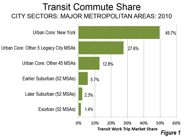
    When is the last time that the entire New York subway was closed with 12 hours notice to make repairs critical to the safety of the system? Or when was the last such shutdown of the London Underground, the Paris Metro, or for that matter the Kolkata Metro or the Caracas Metro, much less the threat of closing lines for months at a time?

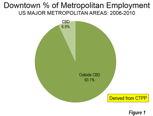
    How many of America’s many light rail systems have shut down as a result of their having failed to sufficiently maintain their safety? There is plenty to criticize about the many new urban rail systems in the United States. They may not carry the number of passengers projected, and often have cost far more than taxpayers were told and they may not have reduced traffic congestion. But they have managed to provide safe transportation to their riders. Only one of America’s rail systems has failed so abjectly in the most fundamental of its responsibilities: America’s subway in Washington.

    My one criticism of the Washington Post story is its preoccupation with finding new sources of funding. Funding levels do not excuse this failure. No one was forcing the powers that be in the Washington area to continue to expand a subway well into the hinterlands while the core was deteriorating. It was the responsibility of the governance structure of the Washington Metropolitan Area Transportation Authority (WMATA), which owns and operates Metro to put the safety of its customers first. If the priorities had been right and the system had not been built out faster than the funding would have prudently permitted, we would not be having this discussion.

    Perhaps the most important lesson to be learned from the Washington Metro failure is that we need to learn the lessons. As the Post article indicates, there are multiple reasons that have contributed to Metro’s failure over decades and a number of WMATA administrations. Certainly no single board of directors or manager bears principal responsibility. It is important to learn exactly what went wrong, and examinations by organizations such as the Government Accountability Office, the Congressional Research Service, the Department of Transportation Inspector General and others would be appropriate. It is important to recognize that Metro is not the typical transit agency that has fallen into financial difficulties. This is a very special case and needs to be treated as the serious governance and management failure that it is. Answers are needed before any new money should be allowed to flow for Metro. For its part, WMATA needs to figure out what it can competently do with the money that is available.

    Wendell Cox is principal of Demographia, an international pubilc policy and demographics firm. He is a Senior Fellow of the Center for Opportunity Urbanism (US), Senior Fellow for Housing Affordability and Municipal Policy for the Frontier Centre for Public Policy (Canada), and a member of the Board of Advisors of the Center for Demographics and Policy at Chapman University (California). He is co-author of the “Demographia International Housing Affordability Survey” and author of “Demographia World Urban Areas” and “War on the Dream: How Anti-Sprawl Policy Threatens the Quality of Life.” He was appointed to three terms on the Los Angeles County Transportation Commission, where he served with the leading city and county leadership as the only non-elected member. He served as a visiting professor at the Conservatoire National des Arts et Metiers, a national university in Paris.

    Washington Metro photo by Ben Schumin. SchuminWeb assumed (based on copyright claims). Own work assumed (based on copyright claims)., April 28, 2016

  • Urbanist Goals Will Mean Fewer Children, more Seniors Needing Government Help

    America’s cognitive elites and many media pundits believe high-density development will dominate the country’s future.

    That could be so, but, if it is the case, also expect far fewer Americans — and far more rapid aging of the population.

    This is a pattern seen throughout the world. In every major metropolitan area in the high-income world for which we found data — Tokyo, Seoul, London, Paris, Toronto, New York, Los Angeles, and the San Francisco Bay area — inner-core total fertility rates are much lower than those in outer areas.

    For example, inner London, notes demographer Wendell Cox, has a fertility rate of 1.6 children per female, which is well below the replacement rate of 2.1.

    The total fertility rate is the average number of children born to women between 15 and 44 years old. In the outer reaches of London, this rate hits 2.0, one-fourth higher.

    In Sydney, Australia, where increasing population density is a sworn goal of planners, the inner city now has a fertility rate of 0.76, compared to 2.0 or more in the outer suburbs.

    Nowhere is the confluence of high density and high prices more evident than East Asia. This region is now home to some of the lowest fertility rates on Earth.

    Take Seoul, South Korea, a paragon of high-density development where high-rise buildings dominate even on the periphery.

    Seoul’s fertility rate is about 1.2, similar to rates found in Tokyo, Singapore and Hong Kong. This is the kind of place urban planners often cite as a role model.

    A recent glowing report in Smithsonian Magazine heralded Seoul as “the city of the future.” Architects, naturally, join the chorus. In 2010, the International Council of Societies of Industrial Design named Seoul the “world design capital.”

    Yet the real frontier of ultra-low fertility may now be coastal China. Both Shanghai and Beijing have fertility rates of roughly 0.7, almost one-third of the replacement rate. Overall, China’s cities have a fertility rate under 0.9.

    Gavin Jones, a leading demographer of Asia, suggests that despite recent easing of China’s one-child policy, the world’s second leading economic power is experiencing a dramatic slowdown in its birthrate.

    In places such as Taiwan, Hong Kong, Tokyo and Singapore, more than one-quarter of women will never marry and even more will never have children.

    The result, Jones suggests, will be a society made up increasingly of single people, one-child families and very old people.

    In less than four decades, according to United Nations projections, Japan will have more people over 80 than under 15.

    This may present more of a challenge to Japan in the future, one professor suggests, than the rise of China. Indeed, over time, notes Jones, the same process will be seen across East Asia, as well as parts of Europe, as the anti-marriage and post-familial trends accelerate.

    “This won’t get better in the future,” he suggests. “The decline is just starting and it’s expanding to other areas, and the process seems inexorable.”

    For now, America, with a fertility rate of 1.89, stands in somewhat less distress, but that could be changed by increasing urban density — the very policy widely adopted by pundits and planners and broadly endorsed by urban developers.

    As Cox has shown, localities with higher densities and higher prices — the two are often coincident — have considerably lower birth rates than areas with lower prices.

    This becomes even more evident when one considers the segment of the population between 5 and 14 years old, when children enter school.

    In 2012, urban areas with the highest percentage of children are predominately lower density and lower cost, including Houston, Dallas-Fort Worth, Riverside-San Bernardino, Atlanta, and Phoenix.

    Urban areas with the lowest percentage of people in these age groups were also the New Urbanist exemplars, such as Boston, San Francisco, New York, and Seattle.

    The geographical nature of low fertility becomes even more clear in maps developed by demographer Ali Modarres.

    These maps show the percentage of households without children present. In regions such as New York, San Francisco, Seattle, D.C. and Chicago, the message is clear: much lower fertility rates in the denser urban cores.

    Maps Source: Demographer Ali Modarres, chair of urban studies at the University of Washington at Tacoma, using data from U.S. Census American Community Survey 2010

    In virtually every case, family size expands the closer one gets to the periphery; in contrast, some of the inner rings show fertility rates that approximate those seen in the hyper-dense Asian regions.

    What this suggests is that a continued focus on forcing Americans to abandon their suburban lifestyles will have a profound impact on the nation’s future competitiveness.

    An aging America will lose much of its current advantage in terms of vitality of our markets and labor force, and will be forced, like many East Asian and European countries, to invest ever more resources to take care of an aging population.

    Yet don’t expect this to affect the planners, environmentalists and their allies in real estate development, who hope to harvest windfall profits by urging and even forcing people to embrace high-density living.

    Their gain will not be to America’s advantage and will consign future generations to persistent slow growth, greater debt and a kind of societal malaise as the family fades in the face of ever greater emphasis on individualism.

    At the same time, an expanded state will be needed to keep the old folks alive in the absence of traditional networks of children and relatives.

    This piece originally appeared at The Washington Examiner.

    Joel Kotkin is executive editor of NewGeography.com and Distinguished Presidential Fellow in Urban Futures at Chapman University, and a member of the editorial board of the Orange County Register. His newest book, The New Class Conflict is now available for pre-order at Amazon and Telos Press. He is author of The City: A Global History and The Next Hundred Million: America in 2050. His most recent study, The Rise of Postfamilialism, has been widely discussed and distributed internationally. He lives in Los Angeles, CA.

    Crossing the street photo by Bigstock.

  • New York, Legacy Cities Dominate Transit Urban Core Gains

    Much attention has been given the increase in transit use in America. In context, the gains have been small, and very concentrated (see: No Fundamental Shift to Transit, Not Even a Shift). Much of the gain has been in the urban cores, which house only 14 percent of metropolitan area population. Virtually all of the urban core gain (99 percent) has been in the six metropolitan areas with transit legacy cities (New York, Chicago, Philadelphia, San Francisco, Boston, and Washington).

    In recent articles, I have detailed a finer grained, more representative picture of urban cores, suburbs and exurbs than is possible with conventional jurisdictional (core city versus suburban) analysis. The articles published so far are indicated in the "City Sector Articles Note," below.

    Transit Commuting in the Urban Core

    As is so often the case with transit statistics, recent urban cores trends are largely a New York story. New York accounted for nearly 80 percent of the increase in urban core transit commuting. New York and the other five metropolitan areas with "transit legacy cities" represented more than 99 percent of the increase in urban core transit commuting (Figure 1). This is not surprising, because the urban cores of these metropolitan areas developed during the heyday of transit dominance, and before broad automobile availability. Indeed, urban core transit commuting became even more concentrated over the past decade. The 99 percent of new commuting (600,000 one-way trips) by transit in the legacy city metropolitan areas was as well above their 88 percent of urban core transit commuting in 2000.

    New York’s transit commute share was 49.7 percent in 2010, well above the 27.6 percent posted by the other five metropolitan areas with transit legacy cities. The urban cores of the remaining 45 major metropolitan areas (those over 1,000,000 population) had a much lower combined transit work trip market share, at 12.8 percent.

    The suburban and exurban areas, with 86 percent of the major metropolitan area population, had much lower transit commute shares. The Earlier Suburban areas (generally median house construction dates of 1946 to 1979, with significant automobile orientation) had a transit market share of 5.7 percent, the Later Suburban areas 2.3 percent and the Exurban areas 1.4 percent (Figure 2).

    The 2000s were indeed a relatively good decade for transit, after nearly 50 years that saw its ridership (passenger miles) drop by nearly three-quarters to its 1992 nadir. Since that time, transit has recovered 20 percent of its loss. Transit commuting has always been the strongest in urban cores, because the intense concentration of destinations in the larger downtown areas (central business districts) that can be effectively served by transit, unlike the dispersed patterns that exist in the much larger parts of metropolitan areas that are suburban or exurban. Transit’s share of work trips by urban core residents rose a full 10 percent, from 29.7 percent to 32.7 percent (Figure 3).

    There were also transit commuting gains in the suburbs and exurbs. However, similar gains over the next quarter century would leave transit’s share at below 5 percent in the suburbs and exurbs, because of its small base or ridership in these areas.

    Walking and Cycling

    The share of commuters walking and cycling (referred to as "active transportation" in the Queen’s University research on Canada’s metropolitan areas) rose 12 percent in the urban core (from 9.2 percent to 10.3 percent), even more than transit. This is considerably higher than in suburban and exurban areas, where walking and cycling remained at a 1.9 percent market share from 2000 to 2010.

    Working at Home

    Working at home (including telecommuting) continues to grow faster than any work access mode, though like transit, from a small base. Working at home experienced strong increases in each of the four metropolitan sectors, rising a full percentage point or more in each. At the beginning of the decade, working at home accounted for less work commutes than walking and cycling, and by 2010 was nearly 30 percent larger.

    The working at home largest gain was in the Earlier Suburban Areas, with a nearly 500,000 person increase. Unlike transit, working at home does not require concentrated destinations, effectively accessing employment throughout the metropolitan area, the nation and the world. As a result, working at home’s growth is fairly constant across the urban core, suburbs and exurbs (Figure 4). Working at home has a number of advantages. For example, working at home (1) eliminates the work trip, freeing additional leisure or work time for the employee, (2) eliminates greenhouse gas emissions from the work trip, (3) expands the geographical area and the efficiency of the labor market (important because larger labor markets tend to have greater economic growth and job creation, and it does all this without (4) requiring government expenditure.

    Driving Alone

    Despite empty premises about transit’s potential, driving remains the only mode of transport capable of comprehensively serving the modern metropolitan area. Driving alone has continued its domination, rising from 73.4 percent to 73.5 percent of major metropolitan area commuting and accounting for three quarters of new work trips. In the past decade, driving alone added 6.1 million commuters, nearly equal to the total of 6.3 million major metropolitan area transit commuters and more than the working at home figure of 3.5 million. To be sure, driving alone added commuters in the urban core, but lost share to transit, dropping from 45.2 percent to 43.4 percent. In suburban and exurban areas, driving alone continued to increase, from 78.2 percent to 78.5 percent of all commuting.).

    Density of Cars

    The urban cores have by far the highest car densities, despite their strong transit market shares. With a 4,200 household vehicles available per square mile (1,600 per square kilometer), the concentration of cars in urban cores was nearly three times that of the Earlier Suburban areas (1,550 per square mile or  600 per square kilometer) and five times that of the Later Suburban areas (950 per square kilometer). Exurban areas, with their largely rural densities had a car density of 100 per square mile (40 per square kilometer).

    Work Trip Travel Times

    Despite largely anecdotal stories about the super-long commutes of those living in suburbs and exurbs, the longest work trip travel times were in the urban cores, at 31.8 minutes one-way. The shortest travel times were in the Earlier Suburbs (26.3 minutes) and slightly longer in the Later Suburbs (27.7 minutes). Exurban travel times were 29.2 minutes. Work trip travel times declined slightly between 2000 and 2010, except in exurban areas, where they stayed the same. The shorter travel times are to be expected with the continuing evolution from monocentric to polycentric and even "non-centric" employment patterns and a stagnant job market (Figure 5).

    Contrasting Transportation in the City Sectors

    The examination of metropolitan transportation data by city sector highlights the huge differences that exist between urban cores and the much more extensive suburbs and exurbs. Overall the transit market share in the urban core approaches nine times the share in the suburbs and exurbs. The walking and cycling commute share in the urban core is more than five times that of the suburbs and exurbs. Moreover, the trends of the past 10 years indicate virtually no retrenchment in automobile orientation, as major metropolitan areas rose from 84 percent suburban and exurban in 2000 to 86 percent in 2010. This is despite unprecedented increases is gasoline prices and the disruption of the housing market during worst economic downturn since the Great Depression.

    —————————-

    Wendell Cox is principal of Demographia, an international public policy and demographics firm. He is co-author of the "Demographia International Housing Affordability Survey" and author of "Demographia World Urban Areas" and "War on the Dream: How Anti-Sprawl Policy Threatens the Quality of Life." He was appointed to three terms on the Los Angeles County Transportation Commission, where he served with the leading city and county leadership as the only non-elected member. He was appointed to the Amtrak Reform Council to fill the unexpired term of Governor Christine Todd Whitman and has served as a visiting professor at the Conservatoire National des Arts et Metiers, a national university in Paris.

    Photograph: DART light rail train in downtown Dallas (by author)

    —————————-

    City Sector Note: Previous articles in this series are listed below:
    From Jurisdictional to Functional Analyses of Urban Cores & Suburbs
    The Long Term: Metro American Goes from 82 percent to 86 percent Suburban Since 1990
    Functional v. Jurisdictional Analysis of Metropolitan Areas
    City Sector Model Small Area Criteria

  • New Central Business District Employment and Transit Commuting Data

    Photographs of downtown skylines are often the "signature" of major metropolitan areas, as my former Amtrak Reform Council colleague and then Mayor of Milwaukee (later President and CEO of the Congress of New Urbanism) John Norquist has rightly said. The cluster of high rise office towers in the central business district (CBD) is often so spectacular – certainly compared with an edge city development or suburban strip center – as to give the impression of virtual dominance. I have often asked audiences to guess how much of a metropolitan area’s employment is in the CBD. Answers of 50 percent to 80 percent are not unusual. In fact, the average is 7 percent in the major metropolitan areas (over 1,000,000) and reaches its peak at only 22 percent in New York (Figure 1), which sports the second largest business district in the world (after Tokyo).

    Only seven of the 52 major metropolitan areas have CBDs with 10 percent or more of employment. Some are much lower. For example, Los Angeles and Dallas have had some of the nation’s tallest skyscrapers outside New York or Chicago for decades, yet these downtowns have only 2.4 percent and 2.3 percent of their metropolitan area employment respectively (Figure 2).

    This and similar information has been summarized in the third edition of Demographia Central Business Districts, which is based on the 2006-2010 Census Transportation Planning Package, a joint venture of the Census Bureau and the American Association of State Highway and Transportation Officials (AASHTO). The two previous editions of the report summarized data from the 1990 and 2000 censuses.

    The Declining Role of Downtown

    Downtowns have become far less important than before World War II, when a large share of American households did not have access to automobiles and when employment was far more concentrated than today. Indeed, the highly concentrated American downtown area is "unique," as Robert Fogelson indicates in Downtown: Its Rise and Fall: 1880-1950, and could be easily located as the destination of the "street railways." Downtown was a product of transit and remains transit’s principal destination today. The concentrated US style CBD form is really quite rare outside other new world nations, such as Canada, Australia, South Africa and New Zealand. Some, but only a few Asian cities have also followed the example, most notably Shanghai, Hong Kong, Nanjing, Chongqing, Singapore, and Seoul.

    The US, however, for all its role as originator of the downtown paradigm has also led the world in employment dispersion. This reflects the dominance in the US of automobiles. Dispersion is more amenable to mobility by the car, which dominates motorized mobility in virtually all major metropolitan areas of North America and Western Europe. This has led in the US to generally shorter work trip travel times and less traffic congestion, according to Tom Tom and Inrix. The continuing expansion of working at home could improve the situation even more.

    New York has the largest CBD in the nation by far, with nearly 2,000,000 jobs. Chicago’s CBD (the Loop and North Michigan Avenue) has about one-quarter as many jobs (500,000) and Washington approximately 375,000. San Francisco, Boston and Philadelphia, also ranked among the nation’s transit "legacy cities," have between 200,000 and 300,000 jobs. Automobile oriented Houston and Atlanta are the largest otherwise, with Houston’s downtown being much more compact than Atlanta’s. Atlanta’s downtown has expanded strongly (and less densely) to the north and includes "Midtown" (Figure 3)

    Transit is About Downtown

    Transit is about downtown. Approximately 55 percent of transit commuting in the United States is to jobs in just six municipalities (not to be confused with metropolitan areas), which I have called transit’s "legacy cities." Most of that commuting is to the six downtown areas. Of course, the city of New York is dominant, which alone accounts for 55 percent of the country’s CBD transit commuting (Figure 4), with much of the balance in the other five legacy cities (Figure 4). Only 14 percent of the CBD commuting is to the other 46 smaller downtowns.

    More than 1.5 million transit commuters converge on jobs in Manhattan every day. In the other five legacy cities, the figure ranges from 100,000 to 300,000 daily. All of the other central business districts draw fewer than 100,000 daily commuters. Seattle ranks 7th, at 60,000, and has double or more the CBD transit commuters of any of the other 44 CBDs (Figure 5). 

    New York has by far the highest transit commuting share of any downtown in the nation. Approximately 77 percent of people who work in the New York central business district commute by transit. The other legacy cities post impressive market shares as well, though well below those of New York. The CBDs in Chicago, Boston, and San Francisco draw between 50 percent and 60 percent of their commuters by transit. Downtown Philadelphia and Washington attract more than 40 percent of their commuters by transit (Figure 6).

    Transit is About Downtown II

    The importance of downtown to transit is also indicated by its predominance in transit commuting destinations. In the New York metropolitan area, with a transit market share of approximately 30 percent, 57 percent of all transit commuting is to downtown jobs. Chicago’s transit commuting is concentrated in downtown to a slightly greater degree than in New York. One half of all the transit commuting in the San Francisco metropolitan area is to downtown. The CBDs of Boston, Philadelphia, and Washington account for between 40 percent and 50 percent of all transit commuting in their downtown areas. Seattle and Pittsburgh also are in this range (Figure 7). Seven of the eight metropolitan areas with the largest transit market shares have a CBD commuting dominance of 40 percent or more (Pittsburgh is the exception).

    The 52 major metropolitan area CBDs combined have less than five percent of the nation’s jobs. Elsewhere, downtowns and otherwise, the other 95 percent of American commuters use transit at only a three percent rate.

    Other Employment Centers

    In a new feature, Demographia Central Business Districts also provides data for selected employment centers other than the principal central business districts. These also include some surprises. For example, downtown Brooklyn, long since engulfed by the expansion of New York, has the second highest transit market share of any employment center identified other than New York, at 60 percent. Across the river, the Jersey City Waterfront area achieves a transit market share of more than 50 percent, greater than the downtowns of legacy cities Philadelphia and Washington.

    Data on supplemental employment center and corridor data is selected and therefore not representative. It is notable that some employment corridors and centers have employment totals that dwarf those of the principal downtown areas in their respective metropolitan areas, such as Los Angeles, Portland, Dallas, and Kansas City.

    With a few exceptions, the transit commuting shares for most of these selected centers and corridors is modest. Many are served by new rail systems, which are simply not up to the task of providing mobility to these dispersed centers. Nor can they provide the radial, high quality service that makes transit such a success in the six legacy city downtowns. For example, the Dallas light rail system provides service along virtually the entire US-75 corridor from north of downtown to Plano. Transit’s share of commutes in this corridor is only 2 percent, far below the downtown Dallas share of 14 percent and the legacy city downtown average of 65 percent.

    Wendell Cox is principal of Demographia, an international public policy and demographics firm. He is co-author of the "Demographia International Housing Affordability Survey" and author of "Demographia World Urban Areas" and "War on the Dream: How Anti-Sprawl Policy Threatens the Quality of Life." He was appointed to three terms on the Los Angeles County Transportation Commission, where he served with the leading city and county leadership as the only non-elected member. He was appointed to the Amtrak Reform Council to fill the unexpired term of Governor Christine Todd Whitman and has served as a visiting professor at the Conservatoire National des Arts et Metiers, a national university in Paris.

  • No Fundamental Shift to Transit: Not Even a Shift

    The American Public Transportation Association (APTA) is out with news of higher transit ridership. APTA President and CEO Michael Melaniphy characterizes the new figures as indicating "a fundamental shift going on in the way we move about our communities.” Others even characterized the results as indicating "shifting consumer preferences." The data shows either view to be an exaggeration.

    1935 and 2013

    This is hardly a reliable time for making judgments about fundamental shifts or shifts in consumer preferences. Economic performance has been more abysmally abnormal only once in the last century –during the Great Depression – than at present.

    The last year, 2013, is the sixth year in a row that total employment, as reported by the Bureau of Labor Statistics was below the peak year of 2007 (Figure 1). This run of dismal job creation was exceeded only between the Great Depression years of 1929 and 1936 in the last 100 years (Note 1). From World War II until the Great Recession, the maximum number of years that employment fell below a previous peak was two, following the 9/11 terrorist attacks (2001 to 2003). The Great Recession may have ended, according to the National Bureau of Economic Research, but the Great Malaise continues as the economy is performing well below historic levels. Judgments about fundamental shifts and consumer choice today are not more reliable than they would have been in the Great Depression year of 1935.

    Transit’s Market Share: Stuck in Neutral

    But more importantly, there is no shift to transit.  APTA is right to point out that transit ridership has grown faster than vehicle travel in the United States since 1995. Nonetheless, transit’s share of urban travel has barely budged, because its 1995 share of travel was so small. This is indicated by Figure 2, which compares the overall market share of transit to that of cars and light trucks from 1995 to 2013. Indeed, the top of Figure 2 (the 100 percent line) is virtually indistinguishable from the personal vehicle share over the entire period. The bottom of the chart (the zero percent line) is virtually indistinguishable from the transit share. This is not the stuff of fundamental shift.

    Commuting: The Story is Not Transit

    A similar pattern of little or no change is indicated by the commuting (work access) data from the Census Bureau’s American Community Survey.

    Over the past five years, as with virtually all the years since such data has been collected, the overwhelming majority of new commuters have driven alone (Figure 3). Indeed, transit has not taken a single net automobile off the road since 1960, and not in the last five years. Between 2007 and 2012, 93 percent of the additional commuters drove alone (Note 2). The drive alone market, which might have been thought to be saturated, actually rose from 76.1 percent to a 76.3 percent market between 2007 and 2012.

    The biggest change has been the continuing loss in carpool use, which dropped from 10.4 percent to 9.7 percent from 2007 to 2012. It is estimated that nearly 450,000 passengers left carpools (excluding drivers), approximately 1.8 passengers for each additional commuter using transit (250,000).

    The largest gain from 2007 to 2012 was in working at home, including telecommuting. Working at home increased from 4.1 percent to 4.4 percent. In actual numbers, working at home added 1.9 times the increase in transit commuting. Its change in market share was greater than that of transit in 42 of the 52 major metropolitan areas. Surprisingly, this includes New York, with its incomparable transit system (by US standards).

    Transit’s share of commuting inched up only 0.1 percentage points between 2007 and 2012. This is so small that if this rate of annual increase were sustained for 50 years, transit’s commute market share would  edge up to only 6 percent (Figure 4), approximately transit’s 1980 market share (doubling to 10 percent would require 130 years). The latest data indicates both gains and losses for transit, with market shares up in 28 major metropolitan areas and down in 24.

    Transit Losses

    In Atlanta, with the nation’s second largest Metro (subway) system built since 1975, a declining overall employment base was accompanied by a loss of 13,000 transit commuters, at the same time that there was an increase in working at home of 19,000.

    In Portland, considered by many around the world to be an urban planning Utopia, the data is hardly favorable. Since 1980, the last year with data before the first of five light rail lines and one commuter rail line opened, transit’s market share has dropped from 8.4 percent to 6.0 percent. While spending billions of dollars on rail, working at home – which involves little or no public expenditure – increased by triple the number of people drawn to transit. And things have not changed materially, even during the claimed "fundamental shift." In the last five years, the working at home increase is more than double that of transit.

    In Los Angeles, ridership at the largest transit agency continues to languish below its 1985 peak, despite having opened 9 light rail, Metro, and rapid busway lines and adding more than 1.5 million residents. Even this decline may be under-stated because of how transit counts passengers. Each time someone steps on a transit vehicle, they are counted (as a boarding). A person who transfers between two or three buses to make a trip counts as two or three boardings, which is what the APTA data reports.

    When rail is added to a transit system, bus services are reconfigured to serve the rail system. This can mean many more boardings from transfers without more passenger trips. This potential inflation of ridership is likely to have occurred not only in Los Angeles, but in all metropolitan areas that added rail systems.

    Transit Gains

    At the same time, gains are being made in some metropolitan areas. Ridership has risen more strongly in transit’s six "legacy cities," the municipalities (not metropolitan areas) of New York, Chicago, Philadelphia, San Francisco, Boston, and Washington. Between 2007 and 2012, 68 percent of the additional transit commuting occurred to employment locations in these six municipalities. This is higher than the 55 percent of national transit commuting that these areas represented in 2012. The much larger share being attracted by these areas in the last 5 years is an indication that transit ridership, already highly concentrated in just a few places, is becoming even more concentrated.  Further, 50 percent to 75 percent of commuters to the corresponding six downtowns reach work by transit.

    Rational Consumer Behavior

    Even when the nation finally emerges from the Great Malaise, only vain hope will be able to conceive of a large scale consumer preference driven shift toward transit. The rational consumer will not choose transit that is slower or less convenient than the car. Where transit access is impractical or impossible, people will use cars. This is the case for most trips in all US metropolitan area, as the Brookings Institution research cited below indicates

    The Brookings Institution research indicated that the average employee in the nation’s major metropolitan areas are able to access fewer than 10 percent of jobs in 45 minutes. This is not only a small number of jobs, but it is a travel time that is approximately twice that of the average employee in the United States (most of whom travel by car).

    More funding for transit cannot solve this problem. The kind of automobile competitive transit system needed to provide rational consumer choice between cars and transit would require annual expenditures rivaling the total personal income in the metropolitan area, as Jean-Claude Ziv and I showed in our 2007 11th World Conference on Transport Research paper (2007). It is no wonder that not a single comprehensive automobile competitive transit system exists or has been seriously proposed in any major US or Western European metropolitan area (Note 3).  Transit is about the largest downtowns and the largest urban cores.

    Unbalanced Coverage

    All of this appears to have escaped many media outlets, which largely parroted the APTA press release. For example, The New York Times, CBS News, the Washington Post, and the Chicago Tribune were as parish newsletters commenting on a homily by the priest, for their failure to report both sides. A notable exception was USA Today, whose reporter consulted outsider Alan Pisarski (who has written for newgeography.com). Pisarski placed the APTA figures in historical context and expressed reservations about restoration of the transit commuting share numbers of 1980 or before. 

    Wendell Cox is principal of Demographia, an international public policy and demographics firm. He is co-author of the "Demographia International Housing Affordability Survey" and author of "Demographia World Urban Areas" and "War on the Dream: How Anti-Sprawl Policy Threatens the Quality of Life." He was appointed to three terms on the Los Angeles County Transportation Commission, where he served with the leading city and county leadership as the only non-elected member. He was appointed to the Amtrak Reform Council to fill the unexpired term of Governor Christine Todd Whitman and has served as a visiting professor at the Conservatoire National des Arts et Metiers, a national university in Paris.

    Photograph: DART light rail train in downtown Dallas (by author)

    ———————

    Note 1: Current Employment Statistics Survey data, 1939 to 2013. 1913 to 1938 estimated from data in Historical Statistics of the United States: Bicentennial Edition.

    Note 2: The source for the commuting data is the American Community Survey of the Census Bureau, which indicates an employment level in 2012 that is higher than in 2007. The Current Employment Statistics Survey of the Bureau of Labor Statistics indicates a decline.

    Note 3: I would be pleased to be corrected on this. In 2004, we issued a challenge on this subject, and while there were some responses, none met the required criteria (see http://demographia.com/db-challenge-choice.htm). The criteria are repeated below:

    To identify an actual system or propose a system that provides the following in an urban area of more than 1,000,000 population:

    · Transit choice (automobile competitive public transport service) for at least 90 percent of trips and passenger kilometers in the particular urban area.

    · Automobile competitiveness is defined as door to door trip times no more than 1.5 times automobile travel time.

    The description of any system not already in operation should also include an estimate of its cost, capital and annual operating.

  • Driving Alone Dominates 2007-2012 Commuting Trend

    New data from the American Community Survey makes it possible to review the trend in mode of access to employment in the United States over the past five years. This year, 2012, represents the fifth annual installment of complete American Community Survey data. This is also a significant period, because the 2007 was a year before the Lehman Brothers collapse that triggered the Great Financial crisis, while gasoline prices increased about a third between 2007 and 2012.

    National Trends

    The work trip access data is shown in Tables 1 and 2. Driving alone continued to dominate commuting, as it has since data was first reported in the 1960 census. In 2007, 76.1 percent of employment access was by driving alone, a figure that rose to 76.3 percent in 2012. Between 2007 and 2012, driving alone accounted for 94 percent of the employment access increase, capturing 1.55 million out of the additional 1.60 million daily one-way trips (Figure 1). The other 50,000 new transit commutes were the final result of increases in working at home, transit and bicycles, minus losses in car pooling and other modes.

    Carpools continued to their long decline, losing share in 43 of the 52 major metropolitan areas. Approximately 810,000 fewer people travel to work by carpools in 2012, which reduced its share from 10.7 percent to 9.7 percent.

    Transit did better, rising from 4.9 percent of work access in 2007 to 5.0 percent in 2012. There was an overall increase of approximately 250,000 transit riders. This increase, however, may be less than might have anticipated in view of the much higher gasoline prices and the imperative for commuters to save money in a more difficult economy.

    Bicycling also did well, rising from a 0.5 percent share in 2007 to a 0.6 percent share in 2012. Approximately 200,000 more people commuted by bicycle by 2012.

    Walking retained its 2.8 percent share, with only a modest 15,000 increase over the period. The largest increase in employment access outside single occupant driving was working at home, which rose from 4.1 percent to 4.4 percent. This translated into an increase of approximately 470,000.

    Metropolitan Area Highlights

    Among the 52 metropolitan areas with more than 1 million population (major metropolitan areas), 47 had drive alone market shares of 70 percent or more. Birmingham was the highest, at 85.6 percent. Surprisingly, this grouping included metropolitan areas with reputations for strong transit ridership, such as Chicago, Philadelphia, and Portland. Four metropolitan areas had drive alone shares of between 60 percent and 70 percent: Seattle, Washington, Boston, and San Francisco, which had the second lowest in the nation at 60.8 percent. As would be expected, New York had by far the lowest drive alone market share at 50.0 percent.

    Consistent with its low drive alone market share, New York led by a large margin the other metropolitan areas in its transit work trip market share. Transit carried 31.1 percent of New York commuters, up nearly a full percentage point from the 30.2 percent in 2007. New York alone accounted for nearly one-half of the growth in transit commuting over the period.

    San Francisco continued to hold onto second place, with a 15.1 percent transit market share, up a full percentage point from 2007. Washington rose to 14.0 percent, up from 13.2 percent in 2007. Boston (11.9 percent) and Chicago (11.0 percent) were the only other major metropolitan areas to achieve a transit work trip market share of more than 10 percent, and were little changed from 2007.

    Working at home continued to increase at a larger percentage rate than any other mode of work access. Four metropolitan areas were tied for the top position in 2012, at 6.4 percent. These included Raleigh, Austin, San Diego, and Portland, all metropolitan areas with a strong high-tech orientation. In San Diego and Portland, where large light rail systems have been developed, working at home is now more popular as a mode of access to work than transit.

    According to 2012 US Census Bureau estimates, the major metropolitan areas comprised 55.2 percent of the national population. These metropolitan areas represented a slightly larger share of total employment, at 57.3 percent. The combined major metropolitan areas also had similar shares to their national population share in each of the employment access modes, ranging from a low of 55.3 percent of communters driving alone to 59.9 percent of walkers. The one exception was transit, where the major metropolitan areas constituted nearly all of commuters, at 90.7 percent, well above their 55.2 percent share of US population (Table 1).

    Table 1
    Distribution of Employment Access (Commuting) by Employment Location: 2012
    SHARE OF WORK ACCESS BY MODE (2012)
      All Employment Drive Alone Car Pool Transit Bike Walk Other Work at Home
    MAJOR METROPOLITAN AREAS 57.3% 55.3% 55.4% 90.7% 59.9% 56.0% 55.6% 59.3%
    Metropolitan Areas with Legacy Cities 17.1% 13.8% 14.4% 65.4% 21.5% 27.8% 18.3% 17.1%
      6 Legacy Cities (see below) 6.0% 2.7% 4.1% 55.1% 12.7% 16.3% 7.8% 4.6%
      Suburban 11.1% 11.1% 10.3% 10.3% 8.8% 11.5% 10.5% 12.6%
      New York Metropolitan Area 6.4% 4.2% 4.5% 39.6% 5.8% 13.6% 8.5% 5.9%
        Legacy City: New York 3.1% 1.0% 1.5% 35.4% 4.2% 9.5% 4.2% 2.5%
        Suburban 3.3% 3.2% 3.0% 4.2% 1.7% 4.1% 4.3% 3.5%
      5 Other Metropolitan Areas with Legacy Cities 10.7% 9.6% 9.9% 25.8% 15.7% 14.2% 9.8% 11.2%
        5 Legacy Cities (CHI, PHI, SF, BOS, WDC) 2.9% 1.7% 2.6% 19.7% 8.5% 6.8% 3.6% 2.1%
        Suburban 7.8% 7.9% 7.3% 6.1% 7.1% 7.5% 6.2% 9.1%
    46 Other Major Metropolitan Areas 40.2% 41.5% 41.0% 25.3% 38.4% 28.2% 37.3% 42.2%
    OUTSIDE MAJOR METROPOLITAN AREAS 42.7% 44.7% 44.6% 9.3% 40.1% 44.0% 44.4% 40.7%
    United States 100% 100% 100% 100% 100% 100% 100% 100%
    Calculated from American Community Survey: 2012 (one year)

    Follow this link to a table containing data for the nation’s major metropolitan areas.

    Commuting Becomes More Concentrated in Legacy Cities

    This concentration of transit commuting was most evident to the six large "transit legacy cities," (the core cities of New York, Chicago, Philadelphia, San Francisco, Boston, and Washington), which still exhibit sufficient remnants of their pre-automobile urban cores that support extraordinarily high transit market shares. The transit legacy cities accounted for 55 percent of all transit commuting destinations in the United States, yet have only six percent of the nation’s jobs. Between 2007 and 2012, the concentration increased, with transit legacy cities accounting 68 percent of the additional transit commutes were between 2007 and 2012. Outside the legacy cities, there was relatively little difference in the share of transit commutes within metropolitan areas with legacy cities and in the other major metropolitan areas (Figure 2)

    The key to the intensive use of transit in the legacy cities is the small pockets of development that are particularly amenable to high transit market shares – the six largest downtown areas (central business districts) in the United States. Most of the commuting to transit legacy cities is to these downtown areas, Yet, the geographical areas of these downtowns is very small. Combined, the six downtown areas are only one-half larger than the land area of Chicago’s O’Hare International Airport. This yields employment per square mile densities of from 40 to 150 times densities of employee residences throughout their respective urban areas.  

    Not surprisingly, transit has very strong market shares to work locations in the transit legacy cities, at 45.8 percent. At the same time, transit commuting to locations outside the transit legacy cities is generally well below the national average. The exception is New York, where transit commuting to suburban locations is 6.4 percent, above the overall national average of 5.0 percent. In the five other metropolitan areas with transit legacy cities, transit commuting to suburban locations is 3.9 percent. This drops to 3.1 percent, overall, in the 46 other major metropolitan areas and 1.1 percent in the rest of the nation (Table 2 and Figure).

    Table 2
    Employment Access (Commuting) by Employment Location: 2012
      Drive Alone Car Pool Transit Bike Walk Other Work at Home
    MAJOR METROPOLITAN AREAS 73.6% 9.4% 7.9% 0.6% 2.8% 1.2% 4.5%
    Metropolitan Areas with Legacy Cities 61.7% 8.2% 19.2% 0.8% 4.6% 1.3% 4.4%
      6 Legacy Cities (see below) 33.9% 6.5% 45.8% 1.3% 7.6% 1.6% 3.3%
      Suburban 76.8% 9.1% 4.7% 0.5% 2.9% 1.1% 5.0%
      New York Metropolitan Area 50.0% 6.8% 31.1% 0.6% 6.0% 1.6% 4.1%
        Legacy City: New York 23.7% 4.6% 57.1% 0.8% 8.6% 1.6% 3.5%
        Suburban 74.8% 8.9% 6.4% 0.3% 3.5% 1.6% 4.6%
      5 Other Metropolitan Areas with Legacy Cities 68.6% 9.0% 12.1% 0.9% 3.7% 1.1% 4.6%
        5 Legacy Cities (CHI, PHI, SF, BOS, WDC) 44.8% 8.6% 33.7% 1.8% 6.5% 1.5% 3.1%
        Suburban 77.6% 9.1% 3.9% 0.6% 2.7% 1.0% 5.1%
    46 Other Major Metropolitan Areas 78.7% 9.9% 3.1% 0.6% 2.0% 1.1% 4.6%
    OUTSIDE MAJOR METROPOLITAN AREAS 79.9% 10.1% 1.1% 0.6% 2.9% 1.3% 4.2%
    United States 76.3% 9.7% 5.0% 0.6% 2.8% 1.2% 4.4%
    Transit legacy cities include the municipalities of New York, Chicago, Philadelphia, San Francisco, Boston & Washington

    Staying the Same

    The big news in the last five years of commuting data is that virtually nothing has changed. This is remarkable, given the greatest economic reversal in 75 years and continuing gasoline price increases that might have been expected to discourage driving alone. Yet, driving alone continues to increase, while the most cost effective mode of car pooling continued to suffer huge losses, while working at home continued to increase strongly.

    Wendell Cox is a Visiting Professor, Conservatoire National des Arts et Metiers, Paris and the author of “War on the Dream: How Anti-Sprawl Policy Threatens the Quality of Life.

    Photograph: DART light rail train in downtown Dallas (by author)

  • Transit Legacy Cities

    Transit’s greatest potential to attract drivers from cars is the work trip. But an analysis of US transit work trip destinations indicates that this applies in large part to   just a few destinations around the nation. This is much more obvious in looking at destinations than the more typical method of analysis, which looks at the residential locations of commuters. This column is adapted from my new Heritage Foundation Backgrounder "Transit Policy in an Era of the Shrinking Federal Dollar."

    Transit Legacy Cities

    Transit commuting is heavily concentrated to destinations in just the six core cities (historical core municipalities) of New York, Chicago, Philadelphia, San Francisco, Boston and Washington (Backgrounder Chart 9). I call them the "transit legacy cities," because their high transit market shares relate to their development before the automobile became dominant. Because there is such a lack of clarity in the use of terms that apply to cities, it is important to emphasize that the transit legacy cities are municipalities, not the surrounding metropolitan areas or urban areas, where the majority of residents live (Note 1). 


    The transit legacy cities account for nearly 55 percent of the nation’s transit commuters, by work trip destinations, according to the American Community Survey (2008-2010). By contrast, the transit legacy cities have an overall national employment market share barely one-tenth their national transit share (6 percent). Moreover, combined, the transit legacy cities cover a land area little larger than the core city (municipality) of Jacksonville, Florida.

    At the same time, the "other side of the coin" is that commuting to other destinations is dominated by the automobile, from the suburbs in metropolitan areas with transit legacy cities, and even more so in the other 45 major metropolitan areas (with more than 1,000,000 population) and the balance of the nation.

    Legacy Cities: Transit’s Strength

    The extent of the concentration in the six transit legacy cities is illustrated in Backgrounder Table 1. In some ways, transit is, first and foremost,  really a New York story. More than one-third of all transit work-trip commuting is to destinations in the core city of New York. The dominance is even greater for high-capacity subways/elevated services, a mode in which where New York represents two-thirds of national commuting.

    The Key: Large, Concentrated, Well Served Downtowns: The concentration of transit commuting in the six transit legacy cities reflects the factor that is probably more responsible than any other for attracting people from cars to transit. This is a highly concentrated downtown area (central business district, or "CBD") from which a dense network of rapid transit services radiates.

    The six transit legacy cities are also home to the six largest CBDs in the nation, where transit’s share of commuting is far higher than compared to the rest of the nation. Approximately three quarters of commuters to the sprawling Manhattan CBD in New York (south of 59th Street) commuted by transit in 2000. Less well known is that New York also contains the CBD with the second largest transit work trip destination, downtown Brooklyn (58 percent), which is followed by downtown Chicago (55 percent).

    In addition, between nearly 40 percent and more than 50 percent of commuters used transit to the CBDs of Boston, San Francisco, Philadelphia and Washington. While covering a land area less than one-half the size of Orlando’s Walt Disney World, these downtowns accounted for 35 percent of national transit commuting.

    Outside the Transit Legacy Cities: Automobile and Work at Home Country

    So what about the 94 percent of US commuters who work outside the transit legacy cities? The answer is that the automobile dominates, and transit has been overtaken by working at home. In the suburban areas of metropolitan areas with transit legacy cities, the car carries 18 times as many people to work locations as transit. In the core municipalities of the 45 major metropolitan areas without legacy cities, cars carry 29 times as many commuters as transit, and 51 times as many in the suburbs. Outside the nation’s major metropolitan areas, cars carry 82 times as many commuters as transit (Backgrounder Table 1)

    Further, outside the transit legacy cities, working at home (including telecommuting) provides access to twenty percent more jobs than transit (Backgrounder Table 3).

    An American Love Affair with the Automobile?

    The enduring myth of the American love affair with automobile is countered by the huge transit market shares to city downtowns . For example, commuters to Manhattan are five times as likely to use transit as cars. On the other hand, commuters to the edge city of Parsippany, on the I-287 corridor in suburban New Jersey are 50 times as likely to use their cars as transit. Yet both employment centers serve the same labor market. The issue is not preferences, it is rather rational choice. It would be irrational for most people to commute to Manhattan by car, principally because of the traffic congestion and cost, particularly for parking. It would similarly be irrational for most people to commute to Parsippany by transit, because it either could not be done at all, or it would take too long.

    Transit’s work trip destination market share is an effective measure of its relevance to the market.

    And lest anyone should counter that the answer is more money, consider this.

    A Cost Not A Revenue Problem

    Portland (with a core city that is not a legacy city) has long been held out as a model for improving transit. Yet, after billions of dollars in federal and local tax subsidies, more than 50 times as many people travel to work to suburban locations by car as by transit. More than five times as many work at home as use transit, and working at home costs taxpayers virtually nothing. Yet, despite all these billions, Portland’s transit system is in crisis. Tri-Met’s  Executive Director Neil McFarlane has warned of 70 percent service cuts over 12 years without substantial changes to union contracts.

    Transit’s fundamental problem is not insufficient revenue but insufficient cost control. Since 1983, national transit expenditures have risen at an inflation-adjusted rate nine times that of its increase in commuters (Note 2). Even if costs were under control, it would be financially impossible to provide automobile-competitive transit throughout the modern urban area, as Professor Jean-Claude Ziv and I showed in our WCTRS paper (Megacities and Affluence: Transport and Land Use Considerations).

    Celebrating Transit

    Yet, beyond its inability to convert generous taxpayer subsidies into corresponding ridership increases, transit deserves credit for the large number of people it moves to jobs in the legacy cities. This success should be celebrated although it remains an impossible, prohibitively expensive, dream elsewhere.

    Wendell Cox is a Visiting Professor, Conservatoire National des Arts et Metiers, Paris and the author of “War on the Dream: How Anti-Sprawl Policy Threatens the Quality of Life.”

    —-

    Note 1: Each of the transit legacy cities has a lower population than the surrounding suburbs. This ranges from nearly 45 percent of the population in the suburbs of the New York metropolitan area to little more than 10 percent in Washington.

    Note 2: Within the first 30 days of my time on the Los Angeles County Transportation Commission, I became convinced that transit’s principal problem was cost control (see Toward More Prosperous Cities). This was then and today remains clear from the above-inflationary escalation of unit costs. Regrettably that trend continues today and has seriously impeded transit’s ability to increase ridership.

    —–

    Photo: Downtown Philadelphia (by author)

  • The New Places Where America’s Tech Future Is Taking Shape

    Technology is reshaping our economic geography, but there’s disagreement as to how. Much of the media and pundits like Richard Florida assert that the tech revolution is bound to be centralized in the dense, often “hip” places where  “smart” people cluster. Some, like Slate’s David Talbot, even fear the new tech wave may erode whatever soul is left to increasingly family free, neo-gilded age San Francisco.

    Such claims have been bolstered by the tech boom of the past few years — especially the explosion of social media firms in places like Manhattan and San Francisco. Yet longer-term trends in tech employment suggest such favored media memes will ultimately prove well off the mark. Indeed, according to an analysis by the Praxis Strategy Group, the fastest growth over the past decade in STEM (science, technology, engineering and mathematics-related) employment has taken place not in the most fashionable cities but smaller, less dense metropolitan areas.

    From 2001 to 2012, STEM employment actually was essentially flat in the San Francisco and Boston regions and  declined 12.6% in San Jose. The country’s three largest mega regions — Chicago, New York and Los Angeles — all lost tech jobs over the past decade. In contrast, double-digit rate expansions of tech employment have occurred in lower-density metro areas such as Austin, Texas; Raleigh, N.C.; Columbus, Ohio; Houston and Salt Lake City. Indeed, among the larger established tech regions, the only real winners have been Seattle, with its diversified and heavily suburbanized economy, and greater Washington, D.C., the parasitical beneficiary of an ever-expanding federal power, where the number of STEM jobs grew 21% from 2001 to 2012, better than any other of the 51 largest U.S. metropolitan statistical areas over that period.

    The question is whether the last two to three years, during which places like San Francisco, New York and Boston have enjoyed stronger STEM growth than their peripheries, represents a paradigm shift or is just a cyclical phenomenon. As with tech in general, the long-term trends are not so city-centric; over the past decade,  the core counties nationwide overall have lost about 1.1% of their tech jobs while more peripheral areas have experienced a gain of 3.5%.

    Today’s urban tech boom looks a lot like a rerun of the dot-com boom of the late 1990s. In that period media-savvy dot-com startups proliferated in such places as South of Market in San Francisco and the Silicon Alley in lower Manhattan. At their height, these firms and their founders were as likely to be covered in the fashion and lifestyle sections as on the business pages.

    Yet by the early 2000s, many of these dot-com darlings had merged, been acquired or simply gone out of business. Anchored largely on hype, they fell victim to flawed business models, and rapid industry consolidation.  In San Francisco, for example, tech employment crashed from a high of 34,000 in 2000 to barely 18,000 four years later. Silicon Alley suffered a similar downward trajectory, losing 15,000 of its 50,000 information jobs in the first five years of the decade.

    The peaking social media boom, marked by the weak performance of Facebook’s IPO last year, suggest another bust at the end of the “hype cycle.” Urban darlings such as  San Francisco’s Zynga and Chicago’s Groupon have floundered in spectacular fashion. More are likely to join them.

    These firms may have generated buzz, but they have done not so well at the mundane task of making money. One problem may be that  the most avid users of social media are largely young people from the “screwed” generation who lack much in the way of spending power — a clear turnoff to advertisers. Now , with venture capital flows declining overall,  cooler heads in the Valley are shifting bets to more business-oriented engineering and research-intensive fields more grounded in marketplace realities.

    And what about the future of the Valley — still home to virtually all the Bay Area’s top tech firms? Its glory days as a job generator and economic exemplar seem to have passed. Between 1970 and 1990 the number of people employed in tech in the Valley more than doubled to 268,000, and then burgeoned to over 540,000 in the 1990s. At the peak of the last tech boom in 2001, the unemployment rate in Santa Clara County was a tiny 3%; the Silicon Valley Manufacturing Group confidently predicted there would be another 200,000 jobs by 2010.

    However, at what may be the peak of the current boom, the number of tech jobs in the Valley remains down from a decade ago and unemployment is over 7.7%, just around the national average. In reality, social media was never going to reverse the downward trajectory in the rate of job growth. Old-line companies like  Hewlett-Packard or Intel, with over 50,000 employees in the U.S. alone, were capable of creating a broad range of opportunities for workers; in contrast, the social media big three of Facebook, LinkedIn and Twitter together have less than 6,500 employees.

    As the social media industry matures and consolidates,   employment is likely to continue shifting to less expensive, business-friendly areas. The Bay Area, where the overall cost of living is 68% higher than the national average and housing is the most expensive in the nation, may continue to attract and retain only the highest-end, best-paid workers. But for the most part they will follow the path of established tech firms such as  Apple, Intel, Adobe, eBay and IBM  to lower-cost places like Austin, Columbus and Salt Lake City. A similar phenomena also can be seen in other urban-centered industries, such as entertainment and finance where  virtually all employment growth is in places like St. Louis, Des Moines and Phoenix, even as the largest centers, New York, Chicago, Boston, Los Angeles and San Francisco have suffered significant job losses.

    Demographic forces may further accelerate these trends. The critical fuel for tech growth, educated labor, is now expanding faster in places like Columbus, Austin, Raleigh, Dallas and Houston than in Boston, San Jose and San Francisco. The old centers may still enjoy a lead in brains, but other places are catching up rapidly.

    Companies may also discover that with many millennials starting to hit their 30s, some may seek to leave their apartments to buy houses and start families. In California new local regulations essentially ban the construction of new single-family homes in some of the state’s biggest metro areas, pricing this option out of reach for all but a few, and forcing a key demographic group to seek residence elsewhere.

    Under these conditions, Silicon Valley will be forced to rely increasingly on inertia and mustering of financial resources than innovation. As a result, the nation’s tech map will continue to expand from the Bay Area, Boston, Seattle and Southern California to emerging metropolitan areas in North Carolina, Texas, Utah, Colorado and the Pacific Northwest. In the future parts of Florida, Phoenix, and even Great Plains cities like Sioux Falls and Fargo could also achieve some critical mass.

    Ultimately, one of the main dynamics of the information age — that even sophisticated tasks  can be done from anywhere — works against the dominion of single hegemonic industry centers like Wall Street, Hollywood and Silicon Valley. The tech sector is particularly vulnerable to declustering, due in large part thanks to the freedom from geography created by technologies of its own making.   Silicon Valley may continue to reap riches from the periodic technology  gold rush , but in the longer term, tech growth will continue its long-term dispersion to ever more parts of the country.

    STEM Occupations in the Nation’s 51 Largest Metropolitan Areas
    MSA Name 2001 – 2012 Growth 2005 – 2012 Growth 2010 – 2012 Growth 2012 Location Quotient LQ Change, 2001 – 2012
    Washington-Arlington-Alexandria, DC-VA-MD-WV 21.1% 12.7% 3.7% 2.19 10.6%
    Riverside-San Bernardino-Ontario, CA 18.6% -1.4% 2.2% 0.57 1.8%
    San Antonio-New Braunfels, TX 18.3% 17.2% 4.5% 0.83 1.2%
    Baltimore-Towson, MD 17.9% 11.4% 3.9% 1.37 15.1%
    Raleigh-Cary, NC 17.9% 14.6% 6.2% 1.53 0.0%
    Las Vegas-Paradise, NV 17.2% -2.6% 0.8% 0.52 4.0%
    Salt Lake City, UT 16.3% 18.1% 7.4% 1.16 4.5%
    Houston-Sugar Land-Baytown, TX 15.7% 17.2% 6.6% 1.20 -2.4%
    Seattle-Tacoma-Bellevue, WA 15.4% 22.2% 6.7% 1.86 8.1%
    Jacksonville, FL 13.0% 6.5% 2.4% 0.87 8.7%
    Austin-Round Rock-San Marcos, TX 12.2% 17.2% 9.1% 1.82 -8.5%
    San Diego-Carlsbad-San Marcos, CA 11.3% 8.0% 2.1% 1.38 6.2%
    Columbus, OH 10.4% 12.8% 4.7% 1.27 7.6%
    Orlando-Kissimmee-Sanford, FL 9.4% -1.1% 0.8% 0.84 -3.4%
    Indianapolis-Carmel, IN 6.9% 6.5% 2.7% 1.04 2.0%
    Nashville-Davidson–Murfreesboro–Franklin, TN 6.7% 3.5% 2.4% 0.77 -1.3%
    Sacramento–Arden-Arcade–Roseville, CA 6.4% 3.5% 0.4% 1.33 2.3%
    Oklahoma City, OK 5.5% 9.6% 6.4% 0.89 -1.1%
    Pittsburgh, PA 5.3% 10.3% 4.9% 1.07 5.9%
    Virginia Beach-Norfolk-Newport News, VA-NC 4.8% 2.3% 0.5% 1.10 3.8%
    Charlotte-Gastonia-Rock Hill, NC-SC 4.3% 8.2% 5.7% 0.99 -3.9%
    Kansas City, MO-KS 4.0% 5.8% 4.6% 1.12 4.7%
    Richmond, VA 3.8% 4.4% 3.4% 0.99 0.0%
    Cincinnati-Middletown, OH-KY-IN 3.7% 5.5% 6.8% 1.02 4.1%
    Buffalo-Niagara Falls, NY 3.2% 6.4% 3.6% 0.90 4.7%
    Dallas-Fort Worth-Arlington, TX 3.1% 11.4% 5.5% 1.19 -5.6%
    San Francisco-Oakland-Fremont, CA 2.5% 15.0% 9.9% 1.63 5.8%
    Phoenix-Mesa-Glendale, AZ 2.3% 3.5% 3.9% 1.05 -6.3%
    Minneapolis-St. Paul-Bloomington, MN-WI 2.2% 6.7% 5.9% 1.31 1.6%
    Portland-Vancouver-Hillsboro, OR-WA 1.6% 6.4% 5.4% 1.19 -3.3%
    Louisville/Jefferson County, KY-IN 0.9% 9.6% 6.9% 0.76 0.0%
    Denver-Aurora-Broomfield, CO 0.5% 10.8% 3.7% 1.43 -2.1%
    Atlanta-Sandy Springs-Marietta, GA -1.0% 5.5% 6.5% 1.07 -2.7%
    Boston-Cambridge-Quincy, MA-NH -1.3% 11.2% 6.0% 1.64 -1.2%
    Providence-New Bedford-Fall River, RI-MA -1.5% -1.6% 1.9% 0.88 2.3%
    Philadelphia-Camden-Wilmington, PA-NJ-DE-MD -2.8% -1.4% 1.4% 1.06 -1.9%
    Hartford-West Hartford-East Hartford, CT -4.5% 1.5% 0.3% 1.10 -3.5%
    New York-Northern New Jersey-Long Island, NY-NJ-PA -4.6% 2.8% 3.2% 0.90 -6.2%
    St. Louis, MO-IL -4.8% -1.7% 1.4% 1.05 -0.9%
    Milwaukee-Waukesha-West Allis, WI -6.1% -0.8% 4.0% 1.00 0.0%
    Tampa-St. Petersburg-Clearwater, FL -6.3% -4.3% 2.5% 0.89 -3.3%
    Miami-Fort Lauderdale-Pompano Beach, FL -6.4% -8.3% 0.6% 0.67 -8.2%
    Los Angeles-Long Beach-Santa Ana, CA -7.1% -3.5% 3.1% 0.98 -5.8%
    Memphis, TN-MS-AR -7.3% -4.0% 0.7% 0.62 -4.6%
    Cleveland-Elyria-Mentor, OH -8.8% -2.1% 4.3% 0.89 1.1%
    Chicago-Joliet-Naperville, IL-IN-WI -10.8% -1.4% 3.5% 0.87 -7.4%
    Birmingham-Hoover, AL -11.4% -8.0% -2.0% 0.76 -8.4%
    Rochester, NY -12.0% -2.1% 4.1% 1.14 -10.2%
    San Jose-Sunnyvale-Santa Clara, CA -12.6% 12.4% 8.3% 3.18 -4.8%
    New Orleans-Metairie-Kenner, LA -16.0% -7.4% -2.4% 0.74 0.0%
    Detroit-Warren-Livonia, MI -17.7% -10.3% 10.5% 1.42 -3.4%
    Analysis by Mark Schill, Praxis Strategy Group
    Data Source: EMSI 2012.4 Class of Worker – QCEW Employees, Non-QCEW Employees & Self-Employed 

    The LQ (location quotient) figure in the table above is the local share of jobs that are STEM occupations divided by the national share of jobs that are STEM occupations. A concentration of 1.0 indicates that a region has the same concentration of STEM occupations as the nation. The analysis covers 80 STEM occupations in all industries.

    Joel Kotkin is executive editor of NewGeography.com and a distinguished presidential fellow in urban futures at Chapman University, and a member of the editorial board of the Orange County Register . He is author of The City: A Global History and The Next Hundred Million: America in 2050. His most recent study, The Rise of Postfamilialism, has been widely discussed and distributed internationally. He lives in Los Angeles, CA.

    This piece originally appeared at Forbes.com.

    Computer engineer photo by BigStockPhoto.com.

  • The Drive-It-Yourself Taxi: A Smooth Ride?

    Despite a corporate sponsor that paid handsomely for the naming rights, Londoners stubbornly refer to our bikesharing system as ‘Boris Bikes’, in a nod to our colourful Mayor, Boris Johnson. But what will we call our new drive-it-yourself taxis? My suggestion: ‘Boris Cabs’ – and they are now a reality here, thanks to Daimler’s car2go service, if you happen to live in one of three small and separate sections of town. But why did a one-way carsharing system have to limp into London, when more than a dozen other cities have welcomed these arrangements with open arms? In the US, car2go first appeared in Austin, Texas, and since then has moved into Washington, D.C, Miami, Portland Oregon, San Francisco, San Diego, and Seattle. It operates in Canada and, on the Continent, in Paris and Amsterdam, among other locations. So why no splashy launch across England’s Capital, and no images of a smiling Boris cutting a ribbon?

    First, roads in London are balkanised. Our regional transport agency (Transport for London) runs the main arteries, and they provide little on-street parking, the mother’s milk of one-way carsharing. That leaves the local streets in the the domain of the 33 boroughs that are each independent municipalities. Car2go is making a brave attempt to get off the ground here by starting with hundreds of cars (the press release reports 500; in practice,170 are in operation two weeks after the launch) in disconnected sections of town, something it has not resorted to anywhere else. Its standard practice is to strike a city-wide deal with whoever’s in charge of on-street parking, and no single agency fits that bill here. What’s the rush? Well, BMW is hot on their heels with its competing DriveNow system, with staff in London well into the advanced stages of planning.

    Second, there is genuine uncertainty about the impacts”. Will we take drive-it-yourself cabs to work, and avoid the crush on the Tube? It would be a very different experience than traditional carsharing — London is said to be Zipcar’s second-biggest market after NYC — which doesn’t work for the daily commute. In the Zipcar model (soon to be the ‘Zipcar by Avis’ model?) you take a car on a round-trip basis and pay by the hour, like filling a parking meter. The novelty of this new generation of drive-yourself cabs lies in their flexibility: as with a taxi meter, you pay by the minute for just the time it takes you to get from ‘A’ to ‘B’, then drop the car off and forget about it.

    What does this mean for traffic congestion? CO2 emissions? What about the cute blue-and-white Smart Fortwo-model cars now parked in your neighbourhood – will they mean less parking for private car owners? Not bloody likely. The expectation is that, in time, enough private car owners will switch to using the fleet’s cars, meaning that on balance fewer cars will need to be parked. But try explaining this to car2go’s new neighbours who are not familiar with the subtleties and will be the ones dealing with the growing pains as we feel our way forward.

    Transport is a long game, so it will be years until we properly understand the impacts of drive-yourself cabs. My research suggests that likely impacts are:

    1) A much larger market than traditional carsharing (about four times as many subscribers)
    2) A roughly 4% reduction in personal car ownership
    3) About a 1% decrease in car driving vehicle miles travelled (including personal cars, traditional carsharing, and drive-yourself cabs)
    4) About a 1% decrease in the number of public transport journeys

    We can be reasonably certain that some surprising impacts will be revealed during field trials, and if at some future point London’s authorities are not happy with the knock-on effects there’s nothing to stop us from regulating the industry like any other. But for the moment we don’t understand it well enough to do anything other than let the operators experiment and keep tabs on what’s happening.

    We just don’t know what the impacts on traffic levels and CO2 will turn out to be, and, frankly, it’s unfair to – as some suggest – hold the industry to a no-net-traffic/CO2 standard. We don’t do that to Black Cabs or [advance-booking-only] minicabs, or indeed to the automotive or urban transport sectors more broadly. A fairer standard, admittedly more complex to administer, would be to assess whether net value is created after accounting for effects on traffic levels, emissions and more. In other words: get the prices right, just like the economics textbooks say.

    The question that needs thinking through is what would transport in London look like if drive-yourself taxi systems went viral and we came to depend on them. What happens, for instance, when instead of 500 of these cabs there are 50,000, and the necessary communication links go down? How would the transport system work if on-road congestion became replaced by virtual queuing to get access to a car? And what about times when the system is under stress, like when a hurricane is approaching, for instance. Is it OK to just flip the switch off on the whole fleet? Who would make this decision, and what guidelines would they follow?

    If the history of the car in cities has taught us anything, it is that we need to be humble about our ability to forecast the future. So what is the way forward for Boris Cabs in London? Start with a small fleet and short-duration contracts. Be clear on the objectives and flexible on the implementation. Keep our options open. It will be an interesting ride.

    Scott Le Vine, AICP is a research associate in transport systems at Imperial College London and a trustee of the shared-mobility NGO Carplus, which serves as the UK’s carsharing trade body. He authored the recent study Car Rental 2.0: Car club [carsharing] innovations and why they matter.

    Flickr photo: Car 2 Go in the 1700 block of Q Street, NW, Washington DC on Easter Sunday, 8 April 2012 by Elvert Barnes Photography

  • Where Americans Are Moving

    The red states may have lost the presidential election, but they are winning new residents, largely at the expense of their politically successful blue counterparts. For all the talk of how the Great Recession has driven people — particularly the “footloose young” — toward dense urban centers, Census data reveal that Americans are still drawn to the same sprawling Sun Belt regions as before.

    An analysis of domestic migration for the nation’s 51 largest metropolitan statistical areas by demographer Wendell Cox shows that the 10 metropolises with the largest net gains from 2000 through 2009 are in the Sun Belt, led by Phoenix, and followed by Riverside-San Bernardino, Calif.; Atlanta; Dallas-Ft. Worth; and Las Vegas.

    Migration has slowed from a high of nearly 2 million annually in 2006 to less than 800,000 last year, but the most recent numbers show that the Sun Belt states, though chastened by the recession, are far from dead, as often alleged. This part of America, widely consigned to what the Bolshevik firebrand Leon Trotsky called the “dustbin of history” by Eastern pundits, somehow manages to continue to draw Americans seeking opportunities, in particular from the large coastal metropolitan regions.

    Migration data for the most recent one-year period available, July 2010 t0 July 2011, show the Great Recession has shaken the rankings up quite a bit within the circle of fast-growth regions. The biggest winner has been Texas. The Lone Star state boasts four of the 10 metro areas with the largest net migration gains for the past two years.  Dallas ranks first, followed by Austin in third place, Houston in fifth and San Antonio in eighth. In contrast, some of the growth leaders over the 2000-09 period, notably Las Vegas, and to a lesser extent Phoenix, have tumbled considerably in the rankings. The lesson here: a strong economy has to be based on something more than gaming, tourism and home construction. Energy, technology, manufacturing and trade are far preferable as an economic base.

    Also posting strong net migration gains for 2010-11 were Miami (second place), Washington, D.C. (sixth), and Seattle (ninth). In each of these areas, economic conditions appear to have improved. The once disastrous condo glut in the Miami area, which includes Dade, Broward and Palm Beach counties, has begun to clear up as foreign buyers pour into the region. Taxpayer-funded Washington is surging with new jobs and the highest incomes in the land. Seattle continues a long-term evolution toward the healthiest of the blue-state private economies. San Francisco, a consistent big loser for the last decade, jumped to 19th, presumably as a result of the current dot.com bubble.

    Another huge turnaround can be seen in New Orleans, which ranked a dismal 43rd for 2000-09 as residents fled not only Katrina but a stagnant, low-wage, corruption-plagued economy. But in our 2010-11 ranking, the Crescent City surged to a respectable 16th, one of the biggest migration turnarounds in the country.

    How about the biggest losers? From 2000-09, the metropolitan areas that suffered the biggest net domestic migration losses resemble something of an urbanist dream team: New York, which saw a net outflow of a whopping 1.9 million citizens, followed by the Los Angeles metro area (-1,337,522), Chicago, Detroit, and, despite recent improvements, San Francisco-Oakland. The raw numbers make it clear that California has lost its appeal for migrants from other parts of the U.S., and has become an exporter of people and talent (and income).

    And despite the cheap money Bernanke-Geithner policies of the past few years that have benefited giant banks centered in the bluest big cities, people continue to leave these areas.  The 2010-11 numbers show the deck chairs on the migratory titanic have stayed remarkably similar, with New York still ranking first among the 51 biggest metro areas for net migration losses, followed by Chicago, Los Angeles, Detroit and Philadelphia. In most of these cases only immigration from abroad, and children of immigrants, have prevented a wholesale demographic decline.

    What can we expect now? It seems clear that the urban-centric policies of the Obama administration have not changed Americans’ migration patterns. The weak recovery has slowed migration, but expensive, overregulated and dense metropolitan areas continue to lose population to lower-cost, less regulated and generally less dense regions. This may speed up as recent tax hikes squeeze the hard-pressed middle class and if, as appears likely, the social media bubble continues to deflate.

    If the economy somehow gains strength, it may only serve to further accelerate these trends. The incipient recovery in housing prices seems likely, at least in places like California and the Northeast, to create yet another bubble. This will give people more incentive to move to less expensive areas, particularly those who can cash in by selling a house in a pricier city and moving to a less expensive one. The differential in housing costs between New York and Tampa-St. Petersburg now stands at historic highs, and near peak bubble highs between Los Angeles and Phoenix; the traditional growth states are looking more attractive all the time for people looking to make quick money in an economy with shrinking opportunities elsewhere. This includes the massive wave of aging boomers, many of whom may see selling a house in California or the Northeast as a way to make up for less than adequate IRAs. The combination of low prices and warmer weather in the past has proven an irresistible one for those retiring or simply down-shifting their careers. This appeal is likely to grow as the senior population expands.

    Other demographic factors could further drive this trend. As the millennial generation ages and starts looking for places to buy homes and raise families, many will seek out places that are both affordable and offer better economic opportunities. These will tend to be in the South and Southwest, particularly Texas, and Plains States metro areas such as Oklahoma City.

    Finally we can expect immigrants, particularly from Asia, to continue to seek out housing bargains and new opportunities primarily in the Sun Belt states, as our recent study of changing Asian settlement patterns revealed. More will be shifting from the high-priced, low-growth big metros for opportunity cities such as Houston, Dallas-Fort Worth, Raleigh and Charlotte.

    Overall we can  expect domestic migration to pick up, and to follow the well-trodden path from the great cities of the Northeast and California to the Sun Belt’s  resurgent boom towns. This may be bad news to many urban pundits and big city speculators, but it also should create new opportunities for more perceptive, and less jaded, investors.

    2010-2011 Net Domestic Migration for the Nation’s 51 Largest Regions
    Rank by Net Flow Metropolitan Area Net Flow Rate Per 1,000 Residents Rank by Rate
    1 Dallas-Fort Worth-Arlington, TX 39,021 6.04 10
    2 Miami-Fort Lauderdale-Pompano Beach, FL 36,191 6.43 9
    3 Austin-Round Rock-San Marcos, TX 30,669 17.47 1
    4 Tampa-St. Petersburg-Clearwater, FL 27,157 9.68 3
    5 Houston-Sugar Land-Baytown, TX 21,580 3.58 16
    6 Washington-Arlington-Alexandria, DC-VA-MD-WV 21,517 3.80 15
    7 Denver-Aurora-Broomfield, CO 19,565 7.59 7
    8 San Antonio-New Braunfels, TX 19,515 8.97 4
    9 Seattle-Tacoma-Bellevue, WA 17,598 5.07 13
    10 Riverside-San Bernardino-Ontario, CA 15,131 3.54 17
    11 Charlotte-Gastonia-Rock Hill, NC-SC 13,778 7.74 6
    12 Raleigh-Cary, NC 13,262 11.53 2
    13 Atlanta-Sandy Springs-Marietta, GA 12,419 2.33 18
    14 Portland-Vancouver-Hillsboro, OR-WA 11,388 5.07 12
    15 Orlando-Kissimmee-Sanford, FL 10,394 4.82 14
    16 New Orleans-Metairie-Kenner, LA 10,153 8.59 5
    17 Nashville-Davidson–Murfreesboro–Franklin, TN 9,323 5.81 11
    18 Oklahoma City, OK 8,746 6.90 8
    19 San Francisco-Oakland-Fremont, CA 5,880 1.35 22
    20 Phoenix-Mesa-Glendale, AZ 5,585 1.32 24
    21 Pittsburgh, PA 3,740 1.59 20
    22 Jacksonville, FL 2,911 2.15 19
    23 Sacramento–Arden-Arcade–Roseville, CA 2,856 1.32 23
    24 Columbus, OH 2,219 1.20 26
    25 Indianapolis-Carmel, IN 1,940 1.10 27
    26 Louisville/Jefferson County, KY-IN 1,886 1.46 21
    27 Richmond, VA 1,546 1.22 25
    28 Salt Lake City, UT 915 0.80 28
    29 San Diego-Carlsbad-San Marcos, CA 816 0.26 29
    30 Minneapolis-St. Paul-Bloomington, MN-WI 536 0.16 30
    31 Baltimore-Towson, MD -1,341 -0.49 32
    32 Boston-Cambridge-Quincy, MA-NH -1,627 -0.36 31
    33 Birmingham-Hoover, AL -2,452 -2.17 35
    34 Buffalo-Niagara Falls, NY -2,558 -2.25 38
    35 San Jose-Sunnyvale-Santa Clara, CA -2,704 -1.46 34
    36 Kansas City, MO-KS -2,820 -1.38 33
    37 Memphis, TN-MS-AR -2,933 -2.22 37
    38 Rochester, NY -3,320 -3.15 40
    39 Hartford-West Hartford-East Hartford, CT -4,749 -3.92 45
    40 Milwaukee-Waukesha-West Allis, WI -4,862 -3.12 39
    41 Providence-New Bedford-Fall River, RI-MA -6,254 -3.91 44
    42 Las Vegas-Paradise, NV -6,353 -3.24 41
    43 Virginia Beach-Norfolk-Newport News, VA-NC -7,086 -4.22 47
    44 Cincinnati-Middletown, OH-KY-IN -7,149 -3.35 42
    45 St. Louis, MO-IL -10,260 -3.64 43
    46 Cleveland-Elyria-Mentor, OH -12,521 -6.04 51
    47 Philadelphia-Camden-Wilmington, PA-NJ-DE-MD -13,133 -2.20 36
    48 Detroit-Warren-Livonia, MI -24,170 -5.64 49
    49 Los Angeles-Long Beach-Santa Ana, CA -50,549 -3.92 46
    50 Chicago-Joliet-Naperville, IL-IN-WI -53,908 -5.68 50
    51 New York-Northern New Jersey-Long Island, NY-NJ-PA -98,975 -5.22 48


    Joel Kotkin is executive editor of NewGeography.com and is a distinguished presidential fellow in urban futures at Chapman University, and contributing editor to the City Journal in New York. He is author of The City: A Global History. His newest book is The Next Hundred Million: America in 2050, released in February, 2010.

    This piece originally appeared at Forbes.

    Dallas photo by Bigstock.